

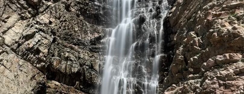
A 200-foot waterfall, right at the edge of a city. That’s the deal with Waterfall Canyon. The Waterfall Canyon Trail starts at the 29th Street Trailhead in Ogden and climbs 1,100 feet through canyon terrain to a waterfall that drops two hundred feet down a sheer rock face. The whole thing is 2.5 miles round trip. It’s one of the most accessible serious waterfalls in Utah, which means it gets crowds on weekends, but it also means you can be standing at the base of something genuinely impressive within an hour of leaving your car. The canyon is dramatic. The waterfall earns the drive. Ogden doesn’t get enough credit for what sits in the hills above it. Here’s everything you need to hike Waterfall Canyon.
Quick Facts
| Trail Name | Waterfall Canyon Trail |
| Location | Uinta-Wasatch-Cache National Forest, Ogden, Utah |
| Coordinates | 41.2109, -111.9319 |
| Distance | 2.5 miles (round trip) |
| Elevation Gain | 1,100 feet |
| Difficulty | Moderate |
| Time | 2-3 hours |
| Dogs Allowed | Yes (on leash) |
| Fee | None |
| View on Alltrails | |
How to Get There
From downtown Ogden, head east on 30th Street to Tyler Avenue. Turn left on Tyler Avenue, which becomes 29th Street. Follow 29th Street east to the end at the 29th Street Trailhead. From Salt Lake City, take I-15 north to Ogden, exit onto 30th Street heading east, and follow the same route. The drive from SLC is about 45 minutes. The trailhead is at the end of a residential street and the signage is clear once you’re on 29th Street.
Parking Information
The 29th Street Trailhead has a large paved lot with solid capacity. On busy weekend mornings in spring and fall it fills, but overflow runs along 29th Street. Arrive before 8 a.m. on weekends to guarantee the lot. Weekdays are significantly calmer. No restroom facilities at the trailhead. Plan accordingly before you leave Ogden’s commercial areas. 
Cell Service and Navigation
Cell service is generally reliable at the trailhead given Ogden’s proximity. It weakens inside the canyon as you gain elevation and get deeper into the terrain. Download your map offline through AllTrails as a backup. The trail is well-marked and the canyon is the obvious navigation cue. Weather can build fast on Wasatch ridgelines. Check the forecast before you go and keep an eye on afternoon thunderstorm potential in summer.
What to Expect on Waterfall Canyon Trail
The Lower Trail
The trail starts with a gradual climb through scrub oak and wildflowers with views opening west toward the Ogden Valley and the Great Salt Lake. It’s a pleasant warm-up before the terrain changes. The lower section is wide and well-worn. Early in the morning the Ogden Valley spreads out in a way that makes the city feel small from even modest elevation.
The Canyon and Waterfall
The trail enters the canyon proper and the character shifts. The walls close in, the terrain gets rockier, and the climb steepens. Scrub oak gives way to mixed canyon vegetation and the sound of water arrives before you see the falls. The final section requires some scrambling over boulders. The waterfall drops 200 feet down a sheer rock face into a pool below. On a strong spring or early summer flow it’s genuinely impressive. The mist at the base keeps the area cool even on warm days. The pool and the rock walls around it make for a natural photography set. Give yourself time here before turning around.
Trail Difficulty and Length
Waterfall Canyon is 2.5 miles round trip with 1,100 feet of elevation gain. The moderate rating is accurate for fit hikers. The gain-to-distance ratio is steeper than the moderate label might suggest. The rocky sections near the waterfall require some scrambling attention. Budget 2 to 3 hours at a comfortable pace with time at the falls. The descent on the same rocky terrain is slower than it looks from the bottom. Good traction matters here.
Dog Friendly?
Yes. Dogs are welcome on leash throughout the trail. The rocky canyon sections and boulder scramble near the falls require a bit of management with a dog but nothing impractical for a trail-ready animal. Bring more water than you think they need. There’s no reliable water source until the falls and the canyon holds heat. In summer heat, start early. 
What to Bring
At least 2 liters of water per person. Trail shoes or hiking boots with solid grip for the rocky sections and scramble near the falls. Sunscreen and a hat for the exposed lower sections. A light layer for the shaded canyon and waterfall area, which stays noticeably cooler. Trekking poles help on the descent on tired legs. A camera with a wide-angle lens if the waterfall is a photography goal. A tripod for long-exposure shots of the falls is worth the carry given how good the shot is at the base.
Best Time to Hike Waterfall Canyon
Spring (April through June) and fall (September through October) are the strongest windows. The waterfall is at peak flow in spring and early summer on snowmelt, and those months offer the most dramatic visual payoff. Summer is hot in the lower exposed sections but the canyon stays cool and the falls run through the season. An early start in summer keeps the exposed lower trail manageable. Fall turns the scrub oak and canyon vegetation into a color show that makes the lower trail worth the hike even if the flow is lighter. Winter brings ice to the rocky scramble sections and cold descents, but seasoned hikers with microspikes can make it work on stable days. For photography, overcast days are ideal at the falls. The diffused light eliminates harsh shadows in the canyon and renders the waterfall and surrounding rock evenly. On clear days, early morning before direct sun reaches the canyon floor gives the best light. The 200-foot drop photographs best with a wide-angle lens from the pool at the base and a neutral density filter for long-exposure water smoothing.
Rules and Regulations
Waterfall Canyon is in the Uinta-Wasatch-Cache National Forest. No permit required, no day-use fee. Leave No Trace fully applies: pack out everything, stay on the established trail to prevent erosion on the steep sections, and yield to uphill hikers on the narrow canyon sections. The waterfall pool area is a high-traffic spot. Be mindful of other hikers wanting their moment at the falls. Check the Wasatch-Cache National Forest site for any current fire restrictions or trail closures before heading out.
Where to Stay Near Ogden
Ogden has a solid range of downtown and suburban lodging options within minutes of the 29th Street Trailhead. Historic 25th Street has boutique lodging close to the action. For hotel points and chain availability check Marriott Bonvoy, IHG Rewards, and Hilton Honors. Salt Lake City is 45 minutes south with significantly more inventory if you’re making Ogden a day trip. 
Camping Nearby
Developed camping near Ogden includes sites in Ogden Canyon and the Monte Cristo area further east. South Fork Campground in Ogden Canyon is a reservable option on recreation.gov that puts you close to the canyon system. Dispersed camping on Wasatch-Cache National Forest land is possible but requires checking current restrictions, which vary by fire season and location. For a basecamp feel close to the Ogden trails, South Fork is the practical choice.
Nearby Adventures
The Bonneville Shoreline Trail accesses from the same 29th Street Trailhead and runs north and south along the ancient Lake Bonneville shoreline with continuous valley views. It’s an excellent option if you want more mileage after the waterfall. Mount Ogden provides a significantly harder summit day with panoramic Wasatch views. Hidden Valley Trail offers a quieter canyon alternative with less traffic. Snowbasin Resort, about 20 minutes east of Ogden up Highway 167, runs summer activities including gondola rides with hiking access to high-elevation terrain and panoramic views without the gain. It’s a solid rest-day option or a way to add alpine views to a Waterfall Canyon day. Downtown Ogden’s Historic 25th Street has restaurants, independent shops, and the Union Station museums covering railroads, natural history, and the American West. It’s worth an evening after a canyon day. The Ogden Nature Center is a low-key 152-acre preserve with walking trails and educational exhibits that works well for families or a short recovery walk.
Plan This Hike
AllTrails has the full Waterfall Canyon Trail with a downloadable map, recent user conditions, and notes on current water flow and trail conditions from other hikers. Checking recent reports is useful for spring snowmelt season when the trail can have mud and the flow is at its best. View on Alltrails AllTrails Pro is worth it for offline maps and GPS tracking. Even on a well-marked trail the canyon sections can feel disorienting when you’re focused on footing.
Chase the Quiet
Two hundred feet of water hitting rock at the end of a canyon that starts at a city street. That gap between ordinary and extraordinary is shorter in Ogden than almost anywhere I’ve been. The trail is steep enough to earn the falls and short enough that it doesn’t take your whole day. You come out of the canyon back into the neighborhood with your legs worked, your head clear, and something worth remembering from the morning. That’s a good deal.
Support the Adventure
To make your walls less boring, check out my photography portfolio and bring a piece of the wild and my story into your home. If you’d like to fuel future adventures, you can donate a coffee on Ko-Fi. Every cup keeps me chasing sunrises and stories. When you shop using my affiliate links, every click helps support this blog at no extra cost to you. It’s a small way to keep Unicorn Adventure alive and kicking while I keep exploring. Subscribe to my mailing list for future updates, new stories, and behind-the-scenes adventures. Stay connected with me on Instagram and Facebook for more photos and daily inspiration. Thanks for being part of the journey, Unicorn Squadron!

Theo Maynard is a landscape photographer and adventure blogger based in Salt Lake City. He chases remote desert and mountain light across the American West, documents it all solo, and shares the journey through Unicorn Adventure. He’s on the autism spectrum, and that’s not a footnote, it’s the whole story. He creates to inspire others to get outside, chase what lights them up, and live their best possible life. Unapologetically himself.