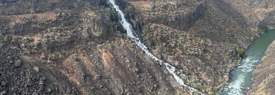
The Malad Gorge is a deep basalt canyon carved by the Malad River in southern Idaho, part of the Thousand Springs State Park complex. The West Rim Trail runs 2 miles along the gorge edge with overlooks of Devil’s Washbowl, a waterfall where the Malad River plunges into the gorge in a powerful display of water against basalt. The canyon walls drop dramatically to the river below, and the visual contrast between the arid high desert plateau you’re walking and the lush river canyon below gives the Malad Gorge a visual character distinct from the Snake River spring sites at Ritter Island and Niagara Springs.
Quick Facts
| Trail Name | Malad Gorge West Rim Trail |
| Location | Thousand Springs State Park, near Hagerman, Idaho |
| Coordinates | 42.8670° N, 114.8538° W |
| Distance | 2.0 miles roundtrip |
| Elevation Gain | 262 feet |
| Difficulty | Moderate |
| Time | 1-2 hours |
| Dogs Allowed | Yes, on leash |
| Fee | $7 per vehicle; Idaho State Parks Passport ($10/year) covers all Idaho state parks |
| AllTrails | View on AllTrails |
How to Get There
From I-84, take Exit 147 (Wendell/Hagerman area) and follow the signs to Thousand Springs State Park, then to the Malad Gorge unit. The Malad Gorge is the most I-84-accessible unit of Thousand Springs State Park; it’s a short drive from the exit and the signage is clear from the highway. The West Rim Trailhead is at the Malad Gorge Visitor Center. From Twin Falls, take I-84 west about 30 miles to Exit 147. From Boise, take I-84 east about 90 miles to Exit 147. From Salt Lake City, I-15 north to I-84 west, approximately 3-3.5 hours to the Malad Gorge exit.
Parking and Entry Information
Free parking at the Malad Gorge Visitor Center. The $7 Thousand Springs State Park entry fee applies. Restrooms at the visitor center before the trailhead. The Idaho State Parks Passport ($10/year) covers all Idaho state park units and is the best value for anyone visiting multiple Thousand Springs stops. 
Cell Service and Navigation
Cell coverage is solid at the visitor center and trailhead given the highway proximity. Download AllTrails offline as standard practice. The trail follows the gorge rim and is well-marked; navigation is not a challenge. The exposure near the gorge edge is the safety consideration, not navigation.
What to Expect on the Malad Gorge West Rim Trail
The Gorge
The Malad Gorge is a narrow, deep basalt canyon with vertical walls that contrast sharply with the flat sagebrush plateau on either side. The Malad River runs at the bottom of the canyon, visible from the rim overlooks as a narrow thread of blue water far below. The gorge is geologically young by Idaho standards; the basalt flows of the Snake River Plain are relatively recent and the Malad River has been cutting through them since the Snake River Plain’s volcanic activity created the drainage patterns. The arid canyon above and the lush river corridor below create the same kind of visual contrast that characterizes the Snake River Canyon further east near Twin Falls, but the Malad Gorge is narrower and more intimate than the Snake River Canyon, and the West Rim Trail’s proximity to the gorge edge makes the drop more viscerally present.
Devil’s Washbowl
Devil’s Washbowl is the named waterfall where the Malad River plunges into the gorge in a powerful concentrated flow. The overlooks on the West Rim Trail provide direct views of the falls and the basin it creates at the base. The waterfall is most impressive in spring when the Malad River’s flow is highest. For photography: the overlooks are the primary photography positions. Wide-angle for the gorge panorama and the drop from rim to river, mid-range for Devil’s Washbowl and the waterfall detail. Morning light from the east reaches the gorge interior before midday; late afternoon illuminates the west-facing canyon walls. The narrow gorge means the falls are in shadow during parts of the day; morning is the priority window for falls photography. 
Trail Difficulty and Length
Moderate is appropriate: 262 feet of gain on a 2-mile trail with gorge edge exposure earns the rating. Budget 1-2 hours for the full out-and-back at a comfortable pace with time at the Devil’s Washbowl overlooks.
Dog Friendly?
Yes. Dogs are permitted on leash. The primary safety consideration for dogs is the gorge edge: the drop is significant and unguarded in sections. Keep dogs on a short leash near the rim and do not allow them near the edge in unguarded sections. Bring water for dogs; no water on the trail.
What to Bring
Water: 1.5 liters for the 2-mile moderate trail. Sun protection for the exposed sagebrush plateau sections. Sturdy shoes with grip for the gorge rim terrain. Camera with a wide-angle and mid-range lens for the gorge panoramas and Devil’s Washbowl detail. Do not bring dogs or children near unguarded gorge edges. 
Best Time to Visit
Late spring through early fall. Spring (April through June) brings the highest Malad River flows and the most dramatic Devil’s Washbowl. Summer is workable with early morning timing to avoid the midday heat on the exposed plateau. Fall brings cooler temperatures and reduced crowd volume. Winter is possible but the rim trail can be icy; the gorge edge exposure in winter ice conditions requires extra caution.
Rules and Regulations
Stay on the designated trail and away from the gorge edge in unguarded sections. Dogs on leash. Do not disturb the fragile sagebrush ecosystem. Pack out all trash. $7 entry fee or Idaho State Parks Passport. No fee for the trail itself beyond the park entry.
Where to Stay Near Malad Gorge
Hagerman is the nearest small town with basic services. Twin Falls, about 30 miles east, has full chain hotel infrastructure. For points travelers, check available Marriott Bonvoy properties, IHG Rewards hotels, and Hilton Honors options in Twin Falls.
Camping Nearby
Thousand Springs State Park has developed camping in some of its units. The Malad Gorge unit may have picnic facilities; check Idaho State Parks for current camping availability. The Hagerman area has developed campgrounds and RV parks along US-30 near the Snake River.
Nearby Adventures
The Thousand Springs State Park catalog from the same area: Ritter Island Loop (1.8 miles / 29 ft), Minnie Miller Springs (0.5 miles), Lemmon Falls, Niagara Springs, Box Canyon Springs Trail (4.3 miles / 396 ft), Auger Falls Park Loop (4.0 miles / 376 ft), and Snake River Canyon Rim Trail (12.3 miles / 872 ft) east toward Twin Falls. Malad Gorge is the northernmost unit of the Thousand Springs complex and the most I-84 accessible; it’s a natural first or last stop on a Thousand Springs multi-stop day. Hagerman Fossil Beds National Monument is a few miles south on US-30: NPS land with the Hagerman Horse fossil type site. The visitor center and interpretive trails add paleontology context to a Malad Gorge and Hagerman area day.
Plan This Hike
AllTrails has the Malad Gorge West Rim Trail mapped with offline capability and condition reports. Plan your hike on AllTrails and download before heading out.
Chase the Quiet
The Malad River has been cutting through the Snake River Plain basalt since the volcanic flows settled here. The gorge is the result: water meeting rock repeatedly, across geologic time, producing a canyon that looks nothing like the flat sagebrush plateau you parked on. That’s the specific thing gorge hiking delivers over viewpoint stops: you’re at the edge of the process that made the landscape you’re standing in. Devil’s Washbowl is the visible, active version of the same work. The falls are still cutting downward. The gorge is still deepening. You’re just there for one frame of it.
Support the Adventure
To make your walls less boring, check out my photography portfolio and bring a piece of the wild and my story into your home. If you’d like to fuel future adventures, you can donate a coffee on Ko-Fi. Every cup keeps me chasing sunrises and stories. When you shop using my affiliate links, every click helps support this blog at no extra cost to you. It’s a small way to keep Unicorn Adventure alive and kicking while I keep exploring. Subscribe to my mailing list for future updates, new stories, and behind-the-scenes adventures. Stay connected with me on Instagram and Facebook for more photos and daily inspiration. Thanks for being part of the journey, Unicorn Squadron!

Theo Maynard is a landscape photographer and adventure blogger based in Salt Lake City. He chases remote desert and mountain light across the American West, documents it all solo, and shares the journey through Unicorn Adventure. He’s on the autism spectrum, and that’s not a footnote, it’s the whole story. He creates to inspire others to get outside, chase what lights them up, and live their best possible life. Unapologetically himself.