The Snake River Canyon Rim Trail runs along the edge of the Snake River Canyon in and around Twin Falls, Idaho, providing uninterrupted views of the canyon, the Snake River 500 feet below, and the Perrine Bridge spanning the canyon at its most iconic point. The trail is paved through the urban Twin Falls sections, making it multi-use: hikers, joggers, cyclists, and families with strollers all use it. The canyon views are consistent and striking throughout. As the longer city-adjacent trail in the Twin Falls catalog, the Rim Trail pairs naturally with the Auger Falls Park Loop on the canyon floor below it: the Rim Trail gives you the scale of the canyon from above, and the Auger Falls Loop gives you the river from inside it. Together they’re the complete Snake River Canyon Twin Falls hiking experience.
Quick Facts
| Trail Name | Snake River Canyon Rim Trail |
| Location | Twin Falls, Idaho |
| Coordinates | 42.5992° N, 114.4793° W (primary access at Twin Falls Visitor Center) |
| Distance | 12.3 miles (full length) |
| Elevation Gain | 872 feet (cumulative over the full 12.3 miles) |
| Difficulty | Moderate |
| Time | 2-6 hours depending on distance hiked |
| Dogs Allowed | Yes, on leash |
| Fee | Free |
| AllTrails | View on AllTrails |
How to Get There
The Snake River Canyon Rim Trail has multiple access points throughout Twin Falls. The two primary starting points are the Twin Falls Visitor Center at 2015 Nielsen Point Place and Centennial Waterfront Park below the Perrine Bridge. The Visitor Center has the largest parking area and easiest access for first-time visitors. Centennial Waterfront Park provides direct access to the Perrine Bridge viewpoint section of the trail. From I-84, take Exit 173 for US-93 south into Twin Falls. Follow US-93 (Blue Lakes Boulevard) south into Twin Falls. From downtown Twin Falls, the Visitor Center and Perrine Bridge are visible and signed from the main streets. Shoshone Falls Park, the eastern end of the trail, is about 5 miles east of downtown Twin Falls on Shoshone Falls Grade. 
Parking Information
Free parking at the Twin Falls Visitor Center (largest lot) and Centennial Waterfront Park. Multiple additional access points and informal parking areas along the rim allow point-to-point hiking or shorter section hikes. Centennial Waterfront Park fills quickly on summer weekends when the Perrine Bridge area draws BASE jumping spectators and tourists in addition to trail users.
Cell Service and Navigation
Cell coverage is consistently solid along the Snake River Canyon Rim Trail given its urban location. Download AllTrails offline as standard practice. The trail is paved and well-marked through the Twin Falls sections; navigation is not a challenge for most of the route. The eastern sections toward Shoshone Falls become more rugged; the AllTrails GPS track is useful for confirming you’re on the correct route.
What to Expect on the Snake River Canyon Rim Trail
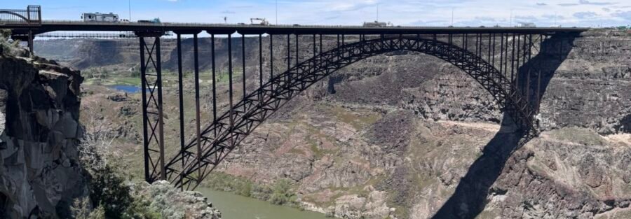
The Perrine Bridge and Canyon Center Section
The Perrine Bridge section near Centennial Waterfront Park is the most iconic stretch of the trail. The bridge itself, 486 feet above the Snake River, spans the canyon at its widest visible point, and the Rim Trail provides viewpoints of the bridge, the canyon walls, and the river below simultaneously. The bridge is also Twin Falls’s BASE jumping site; on weekend summer mornings jumpers are a consistent visual from the trail. The canyon views from the rim are dramatic throughout the Twin Falls section. The basalt canyon walls drop 400-500 feet to the river, and the scale is visible from the level trail surface in a way that rewards slow walking more than running. This section of the trail is also accessible to cyclists and joggers, which means the pace of the rim experience varies widely depending on when and where you’re on it.
Shoshone Falls Section
The eastern end of the trail leads toward Shoshone Falls, the 212-foot waterfall on the Snake River that’s taller than Niagara at peak spring flow. Shoshone Falls Park has its own parking and a $5 seasonal parking fee for the falls viewpoints themselves; the trail connection from the Rim Trail to the Shoshone Falls overlooks integrates the falls into a longer Rim Trail experience from the west side. Completing the trail from the Visitor Center to Shoshone Falls is the full-length 12.3-mile effort. For photography: the Perrine Bridge from the rim trail viewpoints is the most photographed frame on the route. Early morning gives soft light on the canyon walls and fewer people at the bridge viewpoints. Shoshone Falls is most impressive in spring (March through May) when the river flow is highest; the falls reduce significantly in late summer and fall as upstream irrigation draws from the Snake River. Wide-angle for the canyon panoramas, telephoto for the Perrine Bridge arch detail and BASE jumpers. 
Trail Difficulty and Length
Moderate is the appropriate rating for the full 12.3-mile commitment; individual sections are easy. Most visitors hike a 2-5 mile section rather than the full trail. Budget 2-6 hours depending on total distance and pace.
Dog Friendly?
Yes. Dogs are welcome on leash throughout the Snake River Canyon Rim Trail. The paved surface and the wide path through the urban sections make this one of the more dog-friendly long trails in the Twin Falls area. Keep dogs leashed and away from the canyon edge; the drop is 400-500 feet and there are sections without guardrails. The eastern sections toward Shoshone Falls are more rugged; manage leash length in rocky terrain.
What to Bring
Water: 2-3 liters for a 6+ mile section in summer heat. The exposed rim gets warm by mid-morning in July and August. Sun protection throughout; the trail is exposed for most of its length. Sturdy trail shoes for the eastern section toward Shoshone Falls where the terrain becomes rocky. Camera with wide-angle for canyon panoramas and telephoto for the bridge and falls detail. 
Best Time to Visit
The trail is accessible year-round. Spring and fall are the most comfortable temperature windows. Spring offers the highest Snake River flows, making Shoshone Falls most impressive; the canyon’s spring wildflowers bloom through April and May. Summer requires morning timing to avoid the midday heat on the exposed rim. Fall brings cooler temperatures and reduced crowd volume at the Perrine Bridge section. Winter hiking on the paved Twin Falls sections is possible in most conditions; the eastern rocky sections can have ice after winter precipitation. The canyon views in winter with snow on the canyon walls are distinctive and worth a winter morning visit for photography.
Rules and Regulations
Stay on the designated trail and away from the canyon edge in unguarded sections. Dogs on leash. Leave No Trace principles apply in the natural sections. Trash receptacles are available in the urban Twin Falls sections; pack out in the natural eastern sections. No fee.
Where to Stay in Twin Falls
Twin Falls has full chain hotel infrastructure on the US-93 / Blue Lakes Boulevard corridor. For points travelers, check available Marriott Bonvoy properties, IHG Rewards hotels, and Hilton Honors options in Twin Falls.
Nearby Adventures
Auger Falls Park Loop (4.0 miles / 376 ft) is the canyon floor companion: accessing the Snake River from below rather than above, on the same canyon that the Rim Trail looks down into. Doing both the Rim Trail and the Auger Falls Loop is the complete Twin Falls Snake River Canyon experience. Shoshone Falls Park is integrated into the eastern end of the Rim Trail: the 212-foot falls at peak spring flow, $5 seasonal parking fee, accessible for a short add-on from the trail or as a standalone stop. The Thousand Springs State Park cluster west of Twin Falls extends the Idaho canyon hiking catalog: Ritter Island Loop, Lemmon Falls, Niagara Springs, Box Canyon Springs, and Malad Gorge West Rim all accessible from US-30 / Highway 30 along the Snake River canyon.
Plan This Hike
AllTrails has the Snake River Canyon Rim Trail mapped with offline GPS tracking, multiple access point locations, and condition reports. Download before heading out. Plan your hike on AllTrails and use the map to identify which access point works best for the section length you want.
Chase the Quiet
The Snake River Canyon Rim Trail runs through a city. The Twin Falls sections have the Visitor Center parking lot and the BASE jumping crowds and the cyclists and the families. It also has 12 miles of canyon edge with the Snake River 500 feet below and the canyon walls dropping away at your feet and Shoshone Falls at the end. You can start this trail from a parking lot that has a Starbucks within walking distance and finish it at a waterfall taller than Niagara. That’s Twin Falls giving you both versions of southern Idaho at once, and the trail is what connects them.
Support the Adventure
To make your walls less boring, check out my photography portfolio and bring a piece of the wild and my story into your home. If you’d like to fuel future adventures, you can donate a coffee on Ko-Fi. Every cup keeps me chasing sunrises and stories. When you shop using my affiliate links, every click helps support this blog at no extra cost to you. It’s a small way to keep Unicorn Adventure alive and kicking while I keep exploring. Subscribe to my mailing list for future updates, new stories, and behind-the-scenes adventures. Stay connected with me on Instagram and Facebook for more photos and daily inspiration. Thanks for being part of the journey, Unicorn Squadron!

Theo Maynard is a landscape photographer and adventure blogger based in Salt Lake City. He chases remote desert and mountain light across the American West, documents it all solo, and shares the journey through Unicorn Adventure. He’s on the autism spectrum, and that’s not a footnote, it’s the whole story. He creates to inspire others to get outside, chase what lights them up, and live their best possible life. Unapologetically himself.