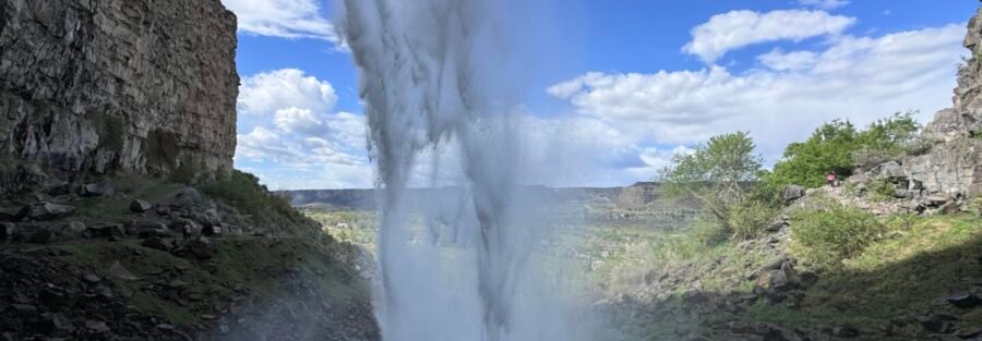
Perrine Coulee Falls is a waterfall in the Snake River Canyon near Centennial Waterfront Park in Twin Falls, Idaho. It’s accessible via a short easy walk from the trailhead near Canyon Springs Road. The falls cascade approximately 200 feet down the canyon wall, fed by the Snake River Plain aquifer rather than the Snake River itself, which means they flow year-round at consistent volume regardless of the season or the river’s flow. That’s the key distinction from Shoshone Falls a few miles east: Shoshone Falls diminishes to near nothing by late summer as irrigation draws down the Snake River upstream; Perrine Coulee Falls doesn’t.
Quick Facts
| Trail Name | Perrine Coulee Falls Trail |
| Location | Near Centennial Waterfront Park, Twin Falls, Idaho |
| Coordinates | 42.5972° N, 114.4717° W |
| Distance | Less than 1 mile roundtrip |
| Elevation Gain | Less than 25 feet |
| Difficulty | Easy |
| Time | 15-30 minutes |
| Dogs Allowed | Yes, on leash |
| Fee | Free (part of the Snake River Canyon park system; no entry fee at this access point) |
| AllTrails | View on AllTrails |
How to Get There
From Twin Falls, take US-93 north across the Perrine Bridge. Immediately after crossing the bridge heading north, turn right onto Canyon Springs Road. Follow Canyon Springs Road toward Centennial Waterfront Park. The Perrine Coulee Falls trailhead is near the park access area. The drive from downtown Twin Falls takes about 5-10 minutes. The falls are visible from the canyon rim at the Perrine Bridge area and also accessible from the canyon floor via Canyon Springs Road. The canyon floor approach via Canyon Springs Road is the primary trail access.
Parking Information
Small parking area near the trailhead off Canyon Springs Road. No parking fee, but the lot is small and street parking is not permitted. Centennial Waterfront Park has additional parking accessible from Canyon Springs Road. Arrive early on busy days; the Perrine Bridge / canyon bottom area draws BASE jumping spectators and Rim Trail users who share the same road access. 
What to Expect at Perrine Coulee Falls
The trail is a short walk from the parking area through the Snake River Canyon vegetation to the falls viewpoint. The falls cascade approximately 200 feet down the canyon wall, the water emerging from the Snake River Plain aquifer through the basalt and flowing as a surface stream before the canyon edge sends it down the cliff face. The sound of the falls is prominent from the viewpoint, and the mist on warm days provides a cooling effect at the base. The falls flow year-round because they’re aquifer-fed. The volume is consistent across seasons, not subject to the spring snowmelt peak and summer irrigation reduction that governs Shoshone Falls and other Snake River-dependent features. This makes Perrine Coulee Falls the reliable waterfall destination in the Twin Falls catalog regardless of when you visit. For photography: the falls cascade down a basalt cliff face in the canyon environment. Morning light from the east illuminates the falls face before midday; afternoon puts the falls in shade from the canyon walls above. Wide-angle for the full falls drop and canyon context, mid-range for the water curtain detail. The consistent year-round flow means fall and winter visits deliver the same falls volume as spring, which makes them worth targeting for less crowded photography windows.
Trail Difficulty and Length
Easy is accurate; this is a flat short walk to a viewpoint. Budget 15-30 minutes for the out-and-back.
Dog Friendly?
Yes. Dogs are welcome on leash. The trail terrain is comfortable for most dogs. Watch dogs on the rocky sections near the falls where surfaces can be slippery from mist. Bring water for dogs. 
What to Bring
Water even for a short walk. Camera for the falls. Comfortable shoes. No special equipment needed. The mist at the base of the falls can be significant on warm days; a lens cloth for photography is useful.
Best Time to Visit
Year-round. The aquifer-fed falls don’t have a peak season in the way Shoshone Falls does. Fall and winter visits have fewer crowds and the same water volume. Early morning for the best light on the falls face. Summer: the mist is a welcome feature in the canyon heat. Spring and fall are comfortable temperatures for the approach walk.
Rules and Regulations
Stay on designated trails. Do not climb on rocks near the waterfall. Pack out all trash. Dogs on leash. No restrooms at the trailhead. No fee at this access point. 
Where to Stay in Twin Falls
Twin Falls has full chain hotel infrastructure on the US-93 / Blue Lakes Boulevard corridor. For points travelers, check available Marriott Bonvoy properties, IHG Rewards hotels, and Hilton Honors options in Twin Falls.
Nearby Adventures
Shoshone Falls (less than 1 mile observation deck, $5 seasonal parking) is the primary Twin Falls waterfall destination and the obvious pairing with Perrine Coulee Falls on the same visit. The two falls offer the comparison between river-fed seasonal flow and aquifer-fed year-round flow from the same Snake River Canyon geography. The Snake River Canyon Rim Trail (12.3 miles / 872 ft) is accessible from the Perrine Bridge / Centennial Waterfront Park area and connects east toward Shoshone Falls and west toward Twin Falls city trails. The Centennial Waterfront Park access point at the canyon bottom is a natural start for the Rim Trail or for combining the canyon floor walk with the Perrine Coulee Falls stop. Auger Falls Park Loop (4.0 miles / 376 ft) is further west on the canyon floor, accessible via Canyon Springs Road from the same access corridor.
Plan This Visit
AllTrails has Perrine Coulee Falls mapped with offline capability. Plan your visit on AllTrails and download before heading down Canyon Springs Road.
Chase the Quiet
Shoshone Falls is five miles east and gets all the attention. At Perrine Coulee Falls, the parking area is small and the falls are audible before you see them. The water comes from the same aquifer that feeds Niagara Springs and Lemmon Falls and the springs at Ritter Island further west: years of underground travel through the basalt, arriving here as a 200-foot waterfall in the canyon wall. No snowmelt required. No season pass. Just consistent, year-round water emerging from the rock and falling into the canyon regardless of what the river is doing five miles east.
Support the Adventure
To make your walls less boring, check out my photography portfolio and bring a piece of the wild and my story into your home. If you’d like to fuel future adventures, you can donate a coffee on Ko-Fi. Every cup keeps me chasing sunrises and stories. When you shop using my affiliate links, every click helps support this blog at no extra cost to you. It’s a small way to keep Unicorn Adventure alive and kicking while I keep exploring. Subscribe to my mailing list for future updates, new stories, and behind-the-scenes adventures. Stay connected with me on Instagram and Facebook for more photos and daily inspiration. Thanks for being part of the journey, Unicorn Squadron!

Theo Maynard is a landscape photographer and adventure blogger based in Salt Lake City. He chases remote desert and mountain light across the American West, documents it all solo, and shares the journey through Unicorn Adventure. He’s on the autism spectrum, and that’s not a footnote, it’s the whole story. He creates to inspire others to get outside, chase what lights them up, and live their best possible life. Unapologetically himself.