

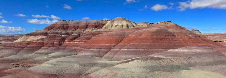
The road is called Cow Dung Road. The destination is bands of red, blue, purple, and gray clay hills that look like they were painted. That contrast is very San Rafael Swell.
The Bentonite Hills are about 12 miles west of Hanksville on BLM land in Wayne County, accessible via a short dirt road off UT-24. There are no formal trails. You drive to the edge of the formation, park, and walk among the undulating clay hills in whatever direction interests you. The colors are the draw: layers of bentonite clay eroded into smooth, vivid bands that shift in hue and intensity depending on the light. Sunrise and sunset are dramatically better than midday.
Here’s what you need to visit the Bentonite Hills.
Quick Facts
| Destination | Bentonite Hills |
| Location | Wayne County, near Hanksville, Utah, BLM land |
| Coordinates | 38.4124, -110.7834 |
| Access | High-clearance vehicle required on Cow Dung Road (dry conditions only) |
| Distance | No formal trail, typically under 1 mile of exploration |
| Elevation Gain | 100-300 feet depending on route |
| Difficulty | Easy (terrain only), access road is the primary challenge |
| Dogs Allowed | Yes (on leash) |
| Fee | None |
How to Get There
From Hanksville, take UT-24 west for approximately 10 miles. Turn right onto Cow Dung Road, an unpaved dirt road heading north. Follow it about 2 miles until you reach the Bentonite Hills. Load the coordinates (38.4124, -110.7834) before leaving UT-24 since there are no signs. High clearance is strongly recommended. The access road is navigable in dry conditions but bentonite clay becomes extremely slick when wet. Do not attempt this road during or after rain. The clay will trap your vehicle. Check the forecast before committing to the turn.
From the south, the Bentonite Hills can also be approached as part of a circuit that includes Goblin Valley State Park and Factory Butte, both within 20 to 30 minutes.
Parking Information
No formal lot. Park along the side of Cow Dung Road or on any flat, stable ground near the hills without blocking the road. No facilities, no restrooms, no trash infrastructure. Everything comes back out with you. This is BLM land with no services whatsoever. Sort out everything in Hanksville before making the drive.

Cell Service and Navigation
No cell service in this corridor. Signal is gone before you turn off UT-24. Download offline maps before leaving Hanksville. Navigation at the hills themselves is intuitive since the formation is visible from the road, but having the GPS coordinates loaded before you turn onto Cow Dung Road confirms you’re on the right track. Let someone know your destination and expected return before heading out. This is genuine BLM desert with no nearby services.
What to Expect at the Bentonite Hills
The Formation
The Bentonite Hills are a series of smooth, undulating clay hills banded in vivid layers of red, blue, purple, and gray. The colors come from different mineral compositions in the bentonite clay, which has eroded into bands over time. The surface has an almost polished quality in dry conditions, smooth and dense compared to the loose sandstone terrain of most nearby desert destinations. The formations are relatively small in geographic scale but the color density and variety make them visually arresting. You can walk the full perimeter of the main formation in under an hour at a leisurely pace.

Exploration
There are no trails. Walk in whatever direction looks interesting. The terrain is mostly easy underfoot in dry conditions, gentle slopes with the clay providing solid footing. Avoid the hills entirely if there is any moisture on the ground. Wet bentonite is dangerously slick, both for walking and for driving the access road. The hills are small enough that orientation is not a serious navigation challenge, but carry your GPS track regardless since the rolling terrain can make it momentarily confusing when you’re in the middle of the formation.
Difficulty and Access
The hills themselves are easy to explore. The access road is the primary challenge: Cow Dung Road requires dry conditions and high-clearance. Once you’re there, the terrain is gentle and suitable for most fitness levels including families and older hikers. The open format means you control the length and physical demand of your visit entirely. A 20-minute photography stop and a 2-hour full exploration are both valid options.

Dog Friendly?
Yes. Dogs are welcome on leash. The clay terrain is easy underfoot in dry conditions. Bring significantly more water than you think your dog needs. There is no shade and the desert floor heats up fast. In summer, visit before 8 a.m. or after 5 p.m.
What to Bring
At least 2 liters of water per person. Sun protection from head to toe. Shoes with moderate grip for the clay surface. A camera: the Bentonite Hills are primarily a photography destination and the light at golden hour on the colored clay is exceptional. A wide-angle lens captures the full color band panorama. A telephoto isolates individual color layer detail. A tripod for the low-light windows at sunrise and sunset when the colors are best. An offline GPS map loaded before you leave the highway. A shovel in the vehicle as a precaution against soft ground on the access road.
Best Time to Visit the Bentonite Hills
Spring (March through May) and fall (September through November) are the primary windows. The clay colors are most vivid in clear, dry conditions and the light at those times of year is exceptional. Summer is hot and the exposed terrain amplifies it. Winter can produce dramatic color contrast with occasional snow on the clay bands, but wet or frozen clay on the access road is a vehicle-trapping risk. The single most important variable regardless of season: do not visit if there has been any recent precipitation. Verify the road is completely dry before turning off UT-24.
For photography, sunrise is the strongest window. The low-angle light hits the colored clay from the side, rendering the texture and banding with maximum depth and contrast. The blue and purple tones are most visible in the hour after sunrise and before sunset. Midday direct sun washes out the color differentiation significantly. A circular polarizing filter helps saturate the clay colors on clear mornings. Overcast days reduce the shadows but also mute the color range.
Rules and Regulations
The Bentonite Hills are BLM land. No permits, no fees. Leave No Trace fully. The bentonite clay is fragile when wet and vehicle tracks or boot prints in wet clay cause long-lasting erosion damage. Never access the hills in wet conditions. Pack out everything. Don’t build cairns or create any structures on the clay surface. Check the BLM Price Field Office for current road conditions before heading out.
Where to Stay Near Hanksville
Hanksville has basic motels and serves as the practical base for the Bentonite Hills, Goblin Valley, and Factory Butte. For more amenities, Moab is about 2 hours east and Green River is about 1.5 hours north. For points travelers, check available Marriott Bonvoy properties, IHG Rewards hotels, and Hilton Honors options in Moab, Green River, or Salt Lake City along your route.
Camping Nearby
Dispersed BLM camping is available on public land throughout the San Rafael Swell surrounding the Bentonite Hills. The area has exceptional night sky access and no facilities. Goblin Valley State Park, about 15 miles northeast, has a campground with hookups reservable through Utah State Parks, the most practical established option for a Hanksville area camping trip.
Nearby Adventures
The Bentonite Hills pair naturally with Factory Butte, the dramatic isolated mesa about 4 miles away that offers hiking around its base and OHV access on the surrounding terrain. Moonscape Overlook, another remote viewpoint in the same corridor, delivers a completely different gray and blue badlands view that contrasts with the vivid clay colors of the Bentonite Hills.
Goblin Valley State Park is about 15 miles northeast and contains both the Valley of the Goblins and the Goblin’s Lair Trail. Little Wild Horse Canyon (8.0 mi / 787 ft) is the best slot canyon hike in the area. Leprechaun Canyon (2.2 mi / 147 ft) off Highway 95 is a shorter slot canyon option. Any of these works as a companion destination for a Bentonite Hills day that needs more mileage.
For the broader Escalante area circuit, Moki Dugway is one of the most dramatic roads in Utah and makes an excellent transition route south from the Hanksville area toward Cedar Mesa and Monument Valley.
Chase the Quiet
Red, blue, purple, and gray clay hills in the middle of the Utah desert, absolutely nobody else present, named after what cattle leave behind on the road in. That’s the Bentonite Hills. Utah has no shortage of dramatic landscapes. This one is strange in a specific and useful way. The colors don’t look real and then the light changes and they look more real than anything else nearby. Go at sunrise and bring a camera. The road name will make more sense on the drive out.
Support the Adventure
To make your walls less boring, check out my photography portfolio and bring a piece of the wild and my story into your home.
If you’d like to fuel future adventures, you can donate a coffee on Ko-Fi. Every cup keeps me chasing sunrises and stories.
When you shop using my affiliate links, every click helps support this blog at no extra cost to you. It’s a small way to keep Unicorn Adventure alive and kicking while I keep exploring.
Subscribe to my mailing list for future updates, new stories, and behind-the-scenes adventures.
Stay connected with me on Instagram and Facebook for more photos and daily inspiration.
Thanks for being part of the journey, Unicorn Squadron!

Theo Maynard is a landscape photographer and adventure blogger based in Salt Lake City. He chases remote desert and mountain light across the American West, documents it all solo, and shares the journey through Unicorn Adventure. He’s on the autism spectrum, and that’s not a footnote, it’s the whole story. He creates to inspire others to get outside, chase what lights them up, and live their best possible life. Unapologetically himself.
1 Comment
Hanksville Utah Travel Guide: Slot Canyons, and more
[…] Full guide: Bentonite Hills […]