

I’ve been to Escalante enough times that it feels like home. Hanksville almost caught up on a single trip.
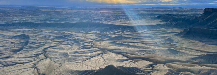
Hanksville is a small town on UT-24 that most people treat as a fuel stop on the way to Capitol Reef or Moab. That’s the wrong call. The landscape surrounding it, stretching into the San Rafael Swell to the west and heading south toward the Henry Mountains, is some of the most genuinely strange and beautiful terrain in the American West. I drove East out for a few days in the off-season and came back with more material than I knew what to do with. Here’s what the trip looked like.
Little Wild Horse Canyon: The Full Loop
I love slot canyons. No apology for leading with that. Little Wild Horse Canyon in the San Rafael Reef was my first stop on this trip and it delivered everything a slot canyon is supposed to deliver.
I did the full 8-mile loop combining Little Wild Horse with Bell Canyon. The slot sections in Little Wild Horse are accessible and family-friendly but don’t let that description flatten them. There were sections narrow enough that I had to take off my pack and shimmy through sideways. A few up-climbs in the 6 to 9-foot range add a real scramble element to an otherwise moderate hike. Little Wild Horse isn’t as tight as Peek-a-Boo in Escalante but it’s longer and more varied, and the full loop means you never repeat terrain.
The moment the canyon opened onto the 4×4 road connection between the two canyons was my first real encounter with the bentonite rock that defines this landscape. The turquoise-blue of the bentonite against the red rock and gravel looks genuinely alien. I stood there for too long taking it in. The San Rafael Swell keeps doing that to you.
Full trail guide: Little Wild Horse Canyon and Bell Canyon Loop

Highway 24: The Drive Is the Destination
I stayed in Torrey on this trip rather than Hanksville, partly for the hotel options and partly because Torrey puts you at the Capitol Reef end of UT-24 with the whole corridor open in front of you. No complaints about that decision, but it means I drove UT-24 multiple times between Torrey and the San Rafael Swell destinations.
That drive. Towering red rock formations, bentonite hills glowing in every color the spectrum produces, the landscape shifting from Capitol Reef geology to San Rafael Swell geology with nothing between them but open sky. I pulled over twice just to look at it. If you’re doing this trip and treating UT-24 as a transit road, you’re doing it wrong. Drive slow. Stop when something pulls you over. The highway earns its own attention.
Long Dong Silver: Some Places Don’t Need Directions
There’s a remote rock formation west of Goblin Valley that goes by an unmistakable name. I found it. I’m not going to tell you how.
The formation crumbles at the slightest touch. It may not exist for much longer. If you seek it out on your own and find it, treat it with respect. That’s the whole note. Some places in the desert are worth protecting by not promoting them. This is one of them.

Factory Butte: Silence at Scale
Factory Butte doesn’t have a trail. You park along the road and walk toward it.
The butte rises abruptly from the flat desert floor like it was placed there on purpose. The surrounding terrain is BLM OHV open area, so there’s vehicle activity on the flat badlands around it, but the mesa itself commands the space in a way that makes everything else feel small. I parked and walked to the base and spent a lot of time just standing next to it.
What got me was the silence. Not city quiet, not trail quiet, actual desert silence where there’s nothing moving in any direction. No wind, no traffic, no other people. Just the butte and the gray badlands stretching away from it in every direction. I didn’t move for a long time. That kind of silence is hard to find and harder to describe when you’re back in it.
Full guide: Factory Butte

Moonscape Overlook: The View From the Rim
The road to Moonscape Overlook shares its first few miles with Factory Butte Road before forking right toward the canyon rim. I drove it in my car and had a few moments that reminded me why high-clearance vehicle recommendations exist. Take those recommendations seriously.
The overlook sits on Skyline Rim above a vast expanse of gray and blue badlands that look nothing like the red rock Utah most people picture. The color palette is muted, lunar, genuinely strange. You can see Factory Butte in the distance from the rim. Having already stood at the base of that mesa makes the view from the overlook even more legible; you understand the scale of the landscape differently when you’ve been inside it.
Full guide: Moonscape Overlook

Bentonite Hills (Rainbow Hills): Cow Dung Road Delivers
Off Highway 24, west of Hanksville, there’s a dirt road called Cow Dung Road. Yes, really. It delivers.
Before you reach the Bentonite Hills, Cow Dung Road passes the Mars Desert Research Station: a working Mars analog research facility that sits in the middle of this landscape because this landscape genuinely resembles Mars. You can’t enter the facility but you can see the habitat modules from the road. I stopped for photos. The combination of the white cylindrical structures against the red sandstone is exactly what you’d expect it to look like.
Then the Bentonite Hills. I was not prepared.
The colors in the clay bands are red, blue, purple, and gray, vivid in a way that desert landscapes usually aren’t. The formations undulate in smooth waves across the terrain. I went up to the famous Instagram vantage point and sat there for a long time. Not taking photos, not doing anything. Just sitting with it. There are moments in this work where the landscape does something you didn’t expect. The Bentonite Hills did that for me on this trip.
Full guide: Bentonite Hills

Goblin Valley State Park: Rookie Mistake Included
I’ll lead with the mistake. The night before visiting Goblin Valley, I bought my day pass online in advance. Efficient, responsible, wrong. I bought it for that night instead of the next day. Classic.
The rangers at the gate were good about it. Still embarrassing.
For the park itself I did Goblin’s Lair, Carmel Canyon Trail, and Valley of the Goblins. Carmel Canyon was the highlight of the three: it has real canyoneering elements, interesting climbs, and significantly fewer people than the main valley. Goblin’s Lair is worth doing specifically for the light inside the cavern dome. Get there mid-morning when the sun angle sends shafts through the rock openings above.
Valley of the Goblins was crowded on a weekend morning, which is what you get with the most accessible hoodoo landscape in Utah. I found a bentonite hill inside the valley that most people walked past. It glowed blue in the sunlight against the brown hoodoos surrounding it. I climbed it and sat on top of it and decided that was a good place to end the Hanksville chapter of this trip.
Full guides: Goblin’s Lair Trail | Valley of the Goblins

The BLM Road Mistake: Two Miles From Sunset
Before I close this out, the confession.
I had planned to drive BLM 1013 between Little Wild Horse Canyon and Factory Butte/Moonscape Overlook to catch sunset on the canyon rim. Good plan. The road had a different opinion. About halfway along the route, the surface deteriorated past what my vehicle could safely handle. I was two miles from Factory Butte. Two miles from the sunset I’d been aiming for.
I turned around. Added two hours to the drive. Arrived at the hotel feeling defeated.
The lesson: bentonite clay roads after any moisture are not negotiable. They’ll take your car and not give it back. Check conditions, carry a shovel, drive high-clearance. These aren’t suggestions in this part of Utah. I drove Estes after that and never had the same problem.
Why Hanksville
Escalante holds the top spot for me. That’s not changing. But Hanksville pushed it for a few days on this trip, and I wasn’t expecting that.
I was sitting on top of the Bentonite Hills with nothing around me and the silence was complete, not muffled traffic, not wind through trees, just actual nothing in every direction, and I started crying. I don’t have a better explanation for that than the one I had in the moment. Some landscapes reach you in ways that bypass whatever defenses you’ve built around yourself. That’s what Hanksville did on this trip. I’ll be back.

Support the Adventure
To make your walls less boring, check out my photography portfolio and bring a piece of the wild and my story into your home.
If you’d like to fuel future adventures, you can donate a coffee on Ko-Fi. Every cup keeps me chasing sunrises and stories.
When you shop using my affiliate links, every click helps support the blog at no extra cost to you. It’s a small way to keep Unicorn Adventure alive and kicking while I keep exploring.
Subscribe to my mailing list for future updates, new stories, and behind-the-scenes adventures.
Stay connected with me on Instagram and Facebook for more photos and daily inspiration.
Thanks for being part of the journey, Unicorn Squadron!

Theo Maynard is a landscape photographer and adventure blogger based in Salt Lake City. He chases remote desert and mountain light across the American West, documents it all solo, and shares the journey through Unicorn Adventure. He’s on the autism spectrum, and that’s not a footnote, it’s the whole story. He creates to inspire others to get outside, chase what lights them up, and live their best possible life. Unapologetically himself.
2 Comments
Jessica Maynard
Love your storytelling and all the tidbits and advice! This is a great resource for anyone thinking of adventuring in these remote spots…(including myself!)
admin
Thank you. I hope this helps you in your adventures. If you have any questions or more recommendations, please reach out and I will do my best to answer any questions you have 🙂