Cathedral Wash is a 3.3-mile roundtrip hike in Glen Canyon National Recreation Area that starts at a highway pullout on US-89A about 1.5 miles from the Navajo Bridge and descends through an increasingly narrow wash to the Colorado River at the base. The wash starts open and wide, and as you move downstream toward the river the walls close in and the scrambling begins. By the time you reach the Colorado River, you’ve moved through several hundred feet of canyon wall and you’re at the water level of the river that carves through the Grand Canyon system below.
Flash flood risk is the primary safety consideration for this trail and it’s not abstract: Cathedral Wash is a drainage basin that collects water from miles of desert plateau above the canyon. A storm that never touches the trailhead can fill the wash with a flash flood in minutes. This is not a hike to do without checking the weather for the entire upstream drainage area.
Quick Facts
|
Trail Name |
Cathedral Wash Trail |
|
Location |
Glen Canyon National Recreation Area, near Marble Canyon, Arizona |
|
Coordinates |
|
|
Distance |
3.3 miles roundtrip |
|
Elevation Gain |
~400 feet (descent into canyon; gain on return) |
|
Difficulty |
Hard (scrambling, uneven terrain, serious flash flood risk) |
|
Time |
2-4 hours |
|
Dogs Allowed |
No |
|
Fee |
Free |
|
AllTrails |
How to Get There
From Page, Arizona, head south on US-89 to the US-89A junction, then west on US-89A. The Cathedral Wash trailhead is approximately 1.5 miles west of the Navajo Bridge at Marble Canyon. Watch for a small pullout on the north side of US-89A. The location is easy to miss at highway speeds; have the GPS coordinates loaded and slow down as you approach the area.
From Kanab, Utah, take US-89 east to the US-89A junction, then head east toward Marble Canyon. The Cathedral Wash pullout is east of the Lees Ferry turnoff on US-89A. From the Grand Canyon South Rim, US-89 north to US-89A leads through Marble Canyon.
From Salt Lake City, plan about 5 hours: I-15 south to US-89 south to US-89A west.
Parking Information
Small unpaved pullout directly off US-89A. Space for several vehicles. No facilities, no fee. The pullout can fill on busy spring and fall days when this trail draws canyon hiking traffic. Arrive early on weekends. The Navajo Bridge interpretive center, 1.5 miles east, has restrooms if you need facilities before the hike.

Cell Service and Navigation
Cell coverage is present on US-89A but drops in the wash as you descend. Download AllTrails offline before leaving Page or Kanab. The route through the wash is self-guiding: the canyon walls direct you downstream toward the river. Navigation isn’t the challenge. Flash flood weather monitoring is the critical pre-hike task.
Before every Cathedral Wash visit: check weather.gov for the entire upstream drainage area of Cathedral Wash and the Marble Canyon / Vermilion Cliffs region. A storm well upstream can produce a flash flood in the wash without any precipitation at the trailhead. If there’s any meaningful storm forecast anywhere in the watershed, do not enter the canyon.
What to Expect on Cathedral Wash Trail
The Upper Wash
The trail drops into Cathedral Wash from the highway pullout and immediately enters the canyon terrain. The upper wash is relatively wide with the canyon walls visible but not confining. The rock is the familiar red-orange Navajo Sandstone and the multi-colored Chinle and Moenkopi formations of the Marble Canyon area. The early sections give you a reading of the terrain and a sense of the scale of what the water has carved through this plateau over time.
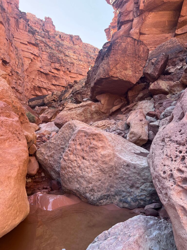
The Narrows and Scrambling
As you descend toward the Colorado River, the wash narrows and the scrambling begins. Sections require climbing down over rock ledges, boulder scrambling, and in some conditions navigating water pools. The 400-foot elevation figure represents the descent to the river; the elevation is recovered on the return. The scrambling sections are not technically difficult in dry conditions but require attention, good footwear, and comfort with uneven and exposed terrain.
The canyon walls close to cathedral-like proportions in the narrowest sections, which is the origin of the trail’s name. Looking up from the narrowest sections of the wash, the visible sky narrows to a strip and the canyon walls tower on both sides. The light and shadow interplay in these sections creates the photographic character that makes this trail distinctive from open wash hiking.
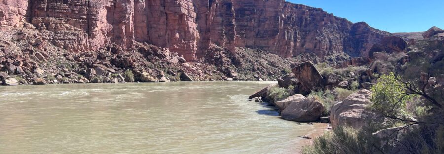
The Colorado River
The trail terminates at the Colorado River at the base of Marble Canyon. The river here is at the entry point to the Grand Canyon system, flowing downstream from the Glen Canyon Dam toward the Inner Gorge. The view from river level looking up at the canyon walls provides a perspective on the canyon depth that the overlooks above don’t offer. The river is not safe for swimming; the current is strong and the water is cold from dam releases. Stand at the bank and appreciate the view.
For photography: the narrowing wash sections are the primary photographic subject. Wide-angle for the canyon wall geometry and the sky strip above. Mid-range for the rock texture and color variation. Morning light from the east reaches into the upper wash sections; the lower narrows are predominantly shaded throughout most of the day. The river at the terminus works best at midday when the sun is high enough to illuminate the canyon floor.
Trail Difficulty and Length
The trail is 3.3 miles with 400 feet of elevation gain. Hard is the accurate rating for a route with technical scrambling, uneven canyon terrain, and serious flash flood risk. The 400 feet of elevation gain is deceptive: it’s all descent to the river and all recovery on the return, meaning the second half of the hike is the hardest climbing. Budget 2-4 hours for the full roundtrip; the scrambling sections add time beyond what the distance alone suggests.
No Dogs Allowed
Dogs are not permitted on Cathedral Wash Trail. This is an NPS regulation specific to this trail within Glen Canyon NRA, likely due to the technical scrambling terrain and the flash flood risk. If you’re traveling with a dog, the Navajo Bridge walk and the Colorado River via Lees Ferry trail are dog-permitted alternatives nearby.

What to Bring
Water: 2-3 liters. The desert terrain and the effort of the return scramble require adequate hydration. Sturdy hiking boots with grip for the scrambling sections; trail runners are insufficient for the rock ledge descents. Layers for the cool shaded canyon sections even in summer. Sun protection for the open upper wash and the highway approach.
Flash flood contingency: know your exit routes at each point in the canyon. Know how far you are from the canyon opening at all times. If you hear water flowing, see the water level rise in any pool, or see the sky darkening upstream, exit the canyon immediately. Do not wait to see what’s coming. Move to the highest accessible point on the canyon wall.
An emergency communication device (Garmin inReach or similar) is appropriate given the remote location and the flash flood risk. Cell coverage in the canyon is absent.
Best Time to Hike Cathedral Wash
Spring (March through May) is the most popular window: mild temperatures, lower monsoon risk than summer, and the desert light is some of the best of the year. Fall (October through November) offers similar conditions with fall color in the vegetation on the upper wash sections.

Rules and Regulations
No dogs. Flash flood weather awareness is an obligation you enforce on yourself; the NPS does not close the trail for every upstream storm but the liability for your safety in flash flood conditions is yours. Stay in the wash on the established route; do not create new paths across the desert plateau above. Leave No Trace throughout. Pack out all trash. No fee required.
Where to Stay Near Marble Canyon
Marble Canyon Lodge and Cliff Dwellers Lodge are on US-89A in the immediate area. Page, Arizona is about 30 miles east with full chain hotel infrastructure. For points travelers in Page, check available Marriott Bonvoy properties in Page, IHG Rewards hotels in Page, and Hilton Honors options near Kanab.
Camping Nearby
Lees Ferry Campground is about 5 miles west on US-89A: a developed NPS campground directly on the Colorado River at the Grand Canyon launch point, one of the most distinctive camping locations in the Southwest. Reservations through recreation.gov. BLM dispersed camping is available on the plateau terrain outside the NPS corridor with standard rules.
Nearby Adventures
Navajo Bridge at Marble Canyon, 1.5 miles east on US-89A, is the companion stop from the same corridor: the historic 1929 pedestrian bridge with California Condor viewing and 470-foot views of the Colorado River below. A natural pairing with Cathedral Wash given the proximity.
Colorado River via Lees Ferry (2.5 miles / 101 ft gain) is the dog-friendly flat riverside walk through the Lees Ferry historical site, accessible about 5 miles west on US-89A. The contrast between Cathedral Wash’s scrambling slot route and the Lees Ferry flat walk along the same river offers two completely different access modes to the same waterway.
The Wire Pass to Buckskin Gulch route in the Paria Canyon-Vermilion Cliffs Wilderness is accessible from House Rock Valley Road off US-89. The other major canyon slot route in this part of the Colorado Plateau, at 5.5 miles with serious flash flood risk of its own.
Plan This Hike
AllTrails has Cathedral Wash Trail mapped with offline GPS tracking and condition reports. The condition reports from recent hikers are worth checking for current wash water level, boulder positions, and weather notes. Plan your hike on AllTrails and pull the offline map before you leave the highway.
Chase the Quiet
Cathedral Wash narrows because the Colorado River has been cutting through this plateau for millions of years and every tributary drainage is in the process of catching up. What you’re walking through is the middle of that process: a canyon not yet as deep as the river that created the drainage gradient, still descending toward a river that keeps cutting lower. The scrambling sections where you lower yourself over ledges are the places where the canyon isn’t finished yet. That’s not a metaphor. It’s geology in real time, visible in the scoured walls and the fresh rock faces. The canyon is still being made.
Support the Adventure
To make your walls less boring, check out my photography portfolio and bring a piece of the wild and my story into your home.
If you’d like to fuel future adventures, you can donate a coffee on Ko-Fi. Every cup keeps me chasing sunrises and stories.
When you shop using my affiliate links, every click helps support this blog at no extra cost to you. It’s a small way to keep Unicorn Adventure alive and kicking while I keep exploring.
Subscribe to my mailing list for future updates, new stories, and behind-the-scenes adventures.
Stay connected with me on Instagram and Facebook for more photos and daily inspiration.
Thanks for being part of the journey, Unicorn Squadron!

Theo Maynard is a landscape photographer and adventure blogger based in Salt Lake City. He chases remote desert and mountain light across the American West, documents it all solo, and shares the journey through Unicorn Adventure. He’s on the autism spectrum, and that’s not a footnote, it’s the whole story. He creates to inspire others to get outside, chase what lights them up, and live their best possible life. Unapologetically himself.