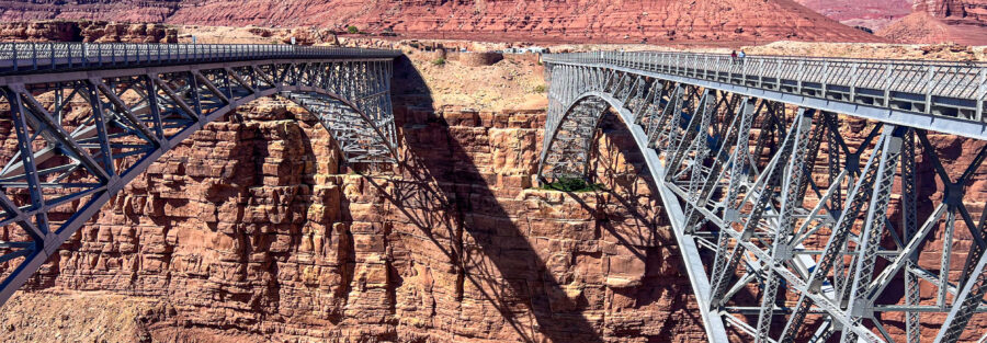
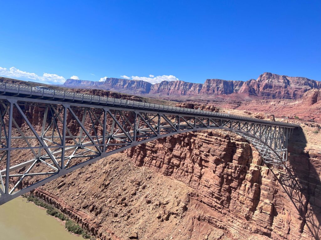
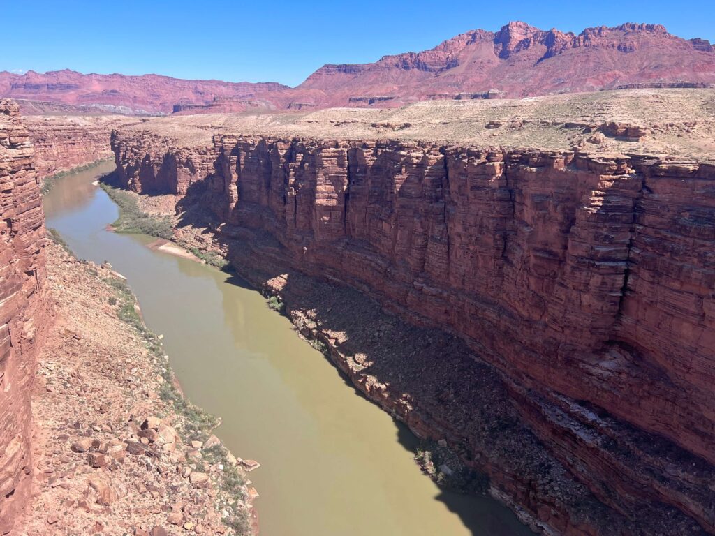
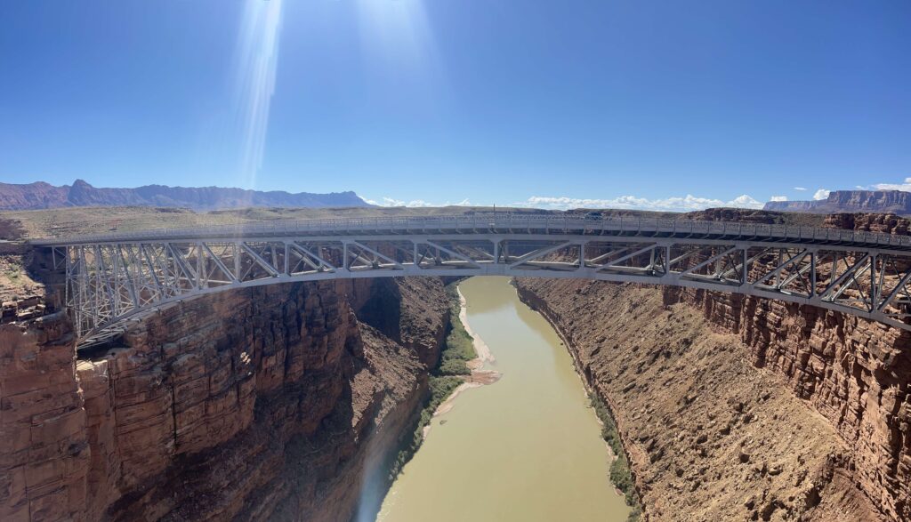
Navajo Bridge spans Marble Canyon at the point where the Colorado River enters the Grand Canyon system, crossing 470 feet above the emerald green water. There are actually two bridges side by side: the original 1929 bridge, now pedestrian-only, and the 1995 replacement highway bridge carrying US-89A traffic. The pedestrian bridge is the destination: a 0.5-mile roundtrip walk with direct views down the canyon walls to the Colorado River below and across to the Vermilion Cliffs rising behind it.
The Marble Canyon / Lees Ferry corridor is a concentrated cluster that sits at the northern entrance to the Grand Canyon. It’s about 15 miles southwest of Page, Arizona on US-89A, and it’s one of the cleanest and most immediate access points to the Colorado River in this entire stretch of the canyon system.
Quick Facts
|
Name |
Navajo Bridge (Marble Canyon Pedestrian Bridge) |
|
Location |
Glen Canyon National Recreation Area, Marble Canyon, Arizona |
|
Coordinates |
|
|
Distance |
~0.5 miles roundtrip (pedestrian bridge walk) |
|
Elevation Gain |
~25 feet |
|
Difficulty |
Easy |
|
Time |
20-45 minutes |
|
Dogs Allowed |
Yes, on leash |
|
Fee |
Free |
|
AllTrails |
How to Get There
From Page, Arizona, take US-89 south approximately 10 miles to the junction with US-89A. Turn west onto US-89A. The Navajo Bridge and Marble Canyon are about 5 miles west on US-89A. The bridge and interpretive center are well-signed from the highway.
From Kanab, Utah, take US-89 east approximately 35-40 miles to the US-89A junction, then head west. From the Grand Canyon South Rim, take US-89 north through Cameron to US-89A heading west. The Lees Ferry/Navajo Bridge corridor is also accessible from the north rim approach via US-89A through Fredonia.
From Salt Lake City, plan about 5 hours: I-15 south to US-89 south to US-89A west. Navajo Bridge is a natural stop on any road trip between Utah canyon country and the Grand Canyon.
Parking Information
Free parking area on the west side of the bridge with access to the interpretive center and the historic pedestrian bridge. Adequate space for most visit volumes; the corridor is less heavily trafficked than the Page area attractions. Restrooms available at the interpretive center. The site is typically uncrowded compared to Horseshoe Bend and the Page cluster, which makes it an excellent early morning or midday stop without parking stress.
Cell Service and Navigation
Cell coverage is present along US-89A and at the Navajo Bridge site given the proximity to the highway. Navigation to the bridge is simple; it’s signed from US-89A. Download AllTrails offline as standard practice if you’re continuing to Cathedral Wash or Lees Ferry from this stop.
What to Expect at Navajo Bridge
The Original Bridge
The 1929 Navajo Bridge was the first permanent highway crossing of the Colorado River downstream of Moab, Utah, connecting Arizona and Utah at Marble Canyon. It carried US-89A traffic for 66 years before the new bridge opened in 1995. The original bridge is now preserved as a pedestrian walkway: you can walk across it, look down 470 feet to the river below through the open arch, and see the 1995 highway bridge parallel to it carrying the current traffic.
The pedestrian bridge is the better photography and view position. The open arch structure provides unrestricted views down and across the canyon in both directions. The highway bridge provides the same river crossing but with traffic barriers and less visual access to the canyon below.
California Condors
Navajo Bridge is one of the most reliable California Condor viewing locations in the American Southwest. The condors, with wingspans up to 9.5 feet, nest in the Marble Canyon cliffs and are frequently seen soaring above the bridge and perching on the canyon walls and bridge structure. The California Condor recovery program, which brought the species back from a handful of captive birds to several hundred wild individuals, is one of the more successful conservation stories in modern wildlife management. Navajo Bridge sits in the middle of their primary Arizona range.
Look up and scan the canyon walls and the bridge structure before crossing. Condors perching on the bridge railing or the canyon wall provide some of the most accessible views of this bird anywhere. Binoculars are worth bringing for the cliff-face nesting area views.
The River and Canyon View
The Colorado River at Marble Canyon runs a deep blue-green in most conditions, the color produced by sediment management from Glen Canyon Dam upstream. The Marble Canyon walls on both sides of the bridge are the beginning of the Grand Canyon system: the river has cut down into the Kaibab limestone and the layers below it, and the exposed cliff faces at the bridge span the upper geological sequence of the canyon.
For photography: the bridge provides east and west views down the canyon corridor. Morning light illuminates the east-facing canyon walls. Late afternoon illuminates the west-facing walls. The condors are unpredictable subjects but worth waiting for. Wide-angle for the full bridge-canyon context, mid-range for the condor detail and the river reflection.
Dog Friendly?
Yes. Dogs are permitted on leash at Navajo Bridge. The short paved bridge walk is comfortable for most dogs. Keep dogs close on the bridge given the open railing structure and the 470-foot drop. Bring water for the desert heat; the Marble Canyon area in summer is exposed and dry.
What to Bring
Water even for a short stop. Binoculars for condor viewing and cliff scanning. Camera with wide-angle and mid-range capability; a telephoto is worth having if condors are a priority. Sun protection for the exposed bridge and parking area. Comfortable shoes.
Best Time to Visit
Spring and fall are the most comfortable temperature windows. The Marble Canyon corridor in summer exceeds 100°F; early morning visits before 9 a.m. are the practical summer approach. The site is accessible year-round and the bridge is open in all seasons.
Condor activity varies throughout the day and season. Early morning and late afternoon tend to have more active soaring behavior as the thermal convection builds. Mid-morning on a warm sunny day with strong thermal development often produces the most condor activity above the canyon. Condors may be visible at any time; the viewing is consistent enough that treating the bridge stop as a guaranteed condor encounter is reasonable expectation-setting.
Rules and Regulations
The original pedestrian bridge is a National Historic Landmark and an active NPS interpretive site. Do not climb on or damage the bridge structure. The site is part of Glen Canyon National Recreation Area; Leave No Trace principles apply. Dogs on leash. No fee required.
Where to Stay Near Marble Canyon
Marble Canyon Lodge and the Cliff Dwellers Lodge are the closest lodging options directly at the US-89A corridor. Page, Arizona is about 15 miles east with full chain hotel infrastructure. Kanab, Utah is about 35-40 miles west. For points travelers in Page, check available Marriott Bonvoy properties in Page, IHG Rewards hotels in Page, and Hilton Honors options near Kanab.
Camping Nearby
Lees Ferry Campground is about 5 miles west on US-89A past the bridge: a developed NPS campground directly on the Colorado River at the Grand Canyon launch point. One of the most unique camping locations in the Southwest for proximity to the Grand Canyon corridor. Reservations through recreation.gov during peak season. The site is popular with Grand Canyon river runners waiting for launch day.
Nearby Adventures
Cathedral Wash Trail is adjacent to the Navajo Bridge / Lees Ferry corridor; a route through a wash leading to the Colorado River. Colorado River via Lees Ferry (2.5 miles / 101 ft gain) is a flat riverside walk through the Lees Ferry historical site at the base of the ferry crossing that gave the area its name.
The Lees Ferry site itself is one of the most historically significant points in American Southwest exploration: the crossing used by John Wesley Powell’s 1869 expedition and the standard Colorado River ferry point for decades before modern bridges. The interpretive history at Lees Ferry is worth time even for non-hikers.
The Page, AZ cluster is 15 miles east: Horseshoe Bend, Dam Overlook, Glen Canyon Bridge, Hanging Garden Trail. A Navajo Bridge morning stop followed by the Page afternoon cluster is a natural road trip sequence.
Plan This Visit
AllTrails has Navajo Bridge mapped with offline capability. Download before heading out from Page or Kanab. Plan your visit on AllTrails and use the GPS waypoint to confirm the parking area.
Chase the Quiet
The 1929 bridge is still standing because it was built well and because the canyon it crosses is one of the places the American Southwest protected before it was fully understood. The California Condors soaring above it are there because a group of people decided in the 1980s that extinction was not an acceptable outcome and spent decades making that decision stick. Both the bridge and the birds are here because of intentional acts of preservation. Standing on the original bridge looking down 470 feet to the Colorado River below, with a condor riding thermals overhead, is a specific version of the American Southwest that doesn’t happen by accident.
Support the Adventure
To make your walls less boring, check out my photography portfolio and bring a piece of the wild and my story into your home.
If you’d like to fuel future adventures, you can donate a coffee on Ko-Fi. Every cup keeps me chasing sunrises and stories.
When you shop using my affiliate links, every click helps support this blog at no extra cost to you. It’s a small way to keep Unicorn Adventure alive and kicking while I keep exploring.
Subscribe to my mailing list for future updates, new stories, and behind-the-scenes adventures.
Stay connected with me on Instagram and Facebook for more photos and daily inspiration.
Thanks for being part of the journey, Unicorn Squadron!

Theo Maynard is a landscape photographer and adventure blogger based in Salt Lake City. He chases remote desert and mountain light across the American West, documents it all solo, and shares the journey through Unicorn Adventure. He’s on the autism spectrum, and that’s not a footnote, it’s the whole story. He creates to inspire others to get outside, chase what lights them up, and live their best possible life. Unapologetically himself.