

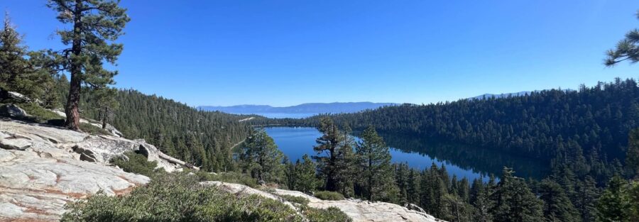
Castle Rock sits on the Nevada side of the Lake Tahoe Basin above the Kingsbury Grade corridor, accessed from a residential street and carrying almost none of the foot traffic that the California-side trailheads see. The trail climbs 700 feet in 3.5 miles through pine forest to a series of granite formations that give the peak its name, with a short summit scramble at the top that earns a panoramic view spanning Lake Tahoe to the west and Carson Valley to the east. It is a moderate hike that delivers more than its mileage suggests.
The Nevada side of Tahoe has trails that most California visitors never find. Castle Rock is one of them. The trailhead is on Andria Drive, a residential street above Kingsbury Grade, and the parking situation is the most complicated part of the hike. Everything above the road is straightforward and rewards the effort.
Quick Facts
|
Trail Name |
Castle Rock Trail |
|
Location |
Kingsbury Grade area, Stateline, Nevada (Lake Tahoe Basin) |
|
Coordinates |
38.9951, -119.8966 (Andria Drive Trailhead) |
|
Distance |
3.5 miles (out and back) |
|
Elevation Gain |
700 ft |
|
Difficulty |
Moderate |
|
Time |
1.5–2.5 hours |
|
Dogs Allowed |
Yes, on leash |
|
Fee |
Free. No permit required. |
How to Get There
The Castle Rock Trailhead is on Andria Drive in the Kingsbury Grade residential area above Stateline, Nevada. From South Lake Tahoe, head north on Kingsbury Grade (Nevada Route 207) for about 20 minutes. Turn onto North Benjamin Drive, then continue onto Andria Drive. The trailhead is at the end of Andria Drive where the road terminates. Signage at the trailhead is minimal. Use GPS navigated to the coordinates or the AllTrails trailhead location before leaving South Lake Tahoe.
Parking Information
No designated parking lot. Park along Andria Drive following all posted signs. Do not block driveways or fire lanes. The residential neighborhood is patrolled and vehicles in violation are ticketed. Parking is tighter on weekends and peak summer days. Arrive before 8 a.m. or visit on a weekday to find street parking easily. No fee, no permit. Carpooling reduces the parking pressure if you’re going with a group.
Cell Service and Navigation
Cell coverage is solid at the Kingsbury Grade level and holds reasonably well on the lower trail. It can drop on the upper sections and near the summit. Download the AllTrails track before leaving. GPS is most useful for finding the Andria Drive trailhead in the residential street grid. Once on trail the route is well-marked to the formation area. The final scramble to the summit is the one section where route-finding benefits from having the track active.
What to Expect on Castle Rock Trail
The Forest Climb
The trail begins in pine forest on a well-maintained dirt path and climbs steadily through the trees. The shade in the lower section makes the climb more comfortable than exposed Tahoe Basin routes. The gradient is consistent but not punishing. As you gain elevation the trees begin to thin and the granite formations that define the upper trail come into view. The forest section covers roughly the first mile and a half of the out-and-back, transitioning gradually from dense cover to open rocky terrain as you approach the summit area.
The Rock Formations
Castle Rock’s granite formations are the distinctive feature of this trail. Large boulders and exposed rock faces define the upper section, with some of the larger formations popular with local rock climbers. Even without climbing gear the formations are worth exploring on foot. The rock has good texture and the scramble to the actual summit of Castle Rock involves hands-on movement over granite slabs that are manageable with confident footing and appropriate footwear.
The Summit View
The summit of Castle Rock delivers a two-direction panorama. Lake Tahoe fills the view to the west, the deep blue framed by the Sierra Nevada peaks on the California side and the pine-covered ridges of the Nevada Basin to the north. Carson Valley opens to the east below the escarpment, a wide sagebrush basin with the Virginia Range visible on the far side. The contrast between the two sides of the Sierra Nevada crest, dense green lake country to the west and open high desert to the east, is one of the more dramatic geographic transitions visible from any single viewpoint in the region.

Trail Difficulty and Length
Castle Rock is 3.5 miles out and back with 700 feet of elevation gain. The moderate rating is accurate. The forest climb is steady and manageable. The upper rock formation section requires more attention on the footing. The summit scramble involves brief hands-on movement over granite that is not technical but does require confidence on uneven rock. Hiking boots with ankle support and grip are worth it over trail runners on this trail. The scramble near the top is the one section to assess carefully if you’re hiking with children or dogs with limited agility.
Dog Friendly?
Dogs are allowed on leash on Castle Rock Trail. The forested lower section is comfortable for most dogs. The upper rock terrain and summit scramble require assessment for your specific dog’s agility. Smaller breeds and older dogs may find the granite scramble near the top awkward. No water sources on trail, bring water for your dog. Watch paws on the rough granite surface near the summit. Pack out all waste.
What to Bring
At least 1.5 liters of water per person. Sunscreen and a hat for the exposed upper trail and summit. Hiking boots with ankle support and aggressive grip for the granite scramble. Trekking poles help on the descent. A camera. The two-direction summit view rewards a wide lens for the full panorama and a telephoto for the Carson Valley detail to the east and the lake formations to the west.

Best Time to Hike Castle Rock
Late spring through fall, typically May through October, is the accessible window. Snow covers the upper trail from late fall through early spring. Summer is the most popular season but Castle Rock stays quieter than the California-side trailheads. Early morning starts on summer weekends beat the heat and the parking competition. Fall is the best overall season, cooler temperatures, thinner crowds, and the Carson Valley visible to the east in its fall character. Check current conditions before late May or October trips when lingering snow on the upper granite can make the scramble significantly more hazardous.
Rules and Regulations
Castle Rock Trail sits within the Lake Tahoe Basin Management Unit. Stay on designated trails. No campfires or open flames anywhere on the trail. Bears are active in the Tahoe Basin. Pack out all food waste and do not leave food unattended at the summit or on trail. Dogs on leash at all times. Pack out all waste. Respect the residential neighborhood at the Andria Drive trailhead. Check current USDA Forest Service fire restrictions before visiting during high fire risk periods, which apply throughout the Tahoe Basin seasonally.
Where to Stay Near South Lake Tahoe
South Lake Tahoe has the broadest lodging range in the basin. The Stateline casino corridor on the Nevada side has full-service resort hotels close to the Kingsbury Grade trailhead access. Marriott Bonvoy covers Lake Tahoe area properties. Hilton Honors has options on both sides of the lake.
Camping Nearby
Fallen Leaf Campground near Fallen Leaf Lake on the California side is one of the better developed campground options near the South Lake Tahoe trailhead cluster. Camp Richardson on the South Shore has both tent sites and full hookup RV sites with lake access. Nevada Beach Campground on the Nevada side of the lake is the closest developed camping to the Kingsbury Grade area. All developed campgrounds in the South Lake Tahoe area require advance reservations in summer through recreation.gov.
Nearby Adventures
The Stateline Overlook Trail is a 1.5-mile moderate trail accessible from the same Kingsbury Grade area with a Lake Tahoe two-state panorama similar to Castle Rock’s but at shorter distance and less elevation gain. The Tahoe Rim Trail is accessible from the Kingsbury Grade area for extended hiking in either direction with consistent lake views. Van Sickle Bi-State Park off the Stateline corridor has moderate trails connecting to the Rim Trail. The Granite Lake and Maggie’s Peak hike on the California side is the more demanding option in the basin at 4 miles and 1,800 feet of gain with an alpine lake and summit view. The Sand Harbor Clear Kayak Tour on the Nevada north shore is the best water experience near the Kingsbury Grade area, about 25 minutes north on Nevada Route 28.
Plan This Hike
AllTrails has Castle Rock documented with GPS track including the summit approach and the scramble route. Download the offline map before leaving South Lake Tahoe. The track is most useful for the Andria Drive trailhead navigation and the upper granite section where the trail becomes less defined through the boulders. Plan your hike on AllTrails here.
Chase the Quiet
Castle Rock summit on a fall morning with Carson Valley to the east still in early shadow and Lake Tahoe catching the first light from the west. The two sides of the Sierra Nevada crest visible simultaneously from the same spot. That geographical contrast, green lake country and open sagebrush desert on either side of the same ridge, is the thing that makes the Nevada Tahoe trails worth knowing about. Most people never cross Kingsbury Grade. Their loss.
Support the Adventure
To make your walls less boring, check out my photography portfolio and bring a piece of the wild and my story into your home.
If you’d like to fuel future adventures, you can donate a coffee on Ko-Fi. Every cup keeps me chasing sunrises and stories.
When you shop using my affiliate links, every click helps support this blog at no extra cost to you. It’s a small way to keep Unicorn Adventure alive and kicking while I keep exploring.
Subscribe to my mailing list for future updates, new stories, and behind-the-scenes adventures.
Stay connected with me on Instagram and Facebook for more photos and daily inspiration.
Thanks for being part of the journey, Unicorn Squadron!

Theo Maynard is a landscape photographer and adventure blogger based in Salt Lake City. He chases remote desert and mountain light across the American West, documents it all solo, and shares the journey through Unicorn Adventure. He’s on the autism spectrum, and that’s not a footnote, it’s the whole story. He creates to inspire others to get outside, chase what lights them up, and live their best possible life. Unapologetically himself.