Alstrom Point is a promontory in Glen Canyon National Recreation Area with an unobstructed 360-degree view over Lake Powell and the surrounding canyon country. Getting there requires driving Smoky Mountain Road, a 25-mile one-way dirt road from Big Water, Utah, with deep sand patches, rocky drops, and rutted climbs that demand high-clearance 4WD and the willingness to take it slow. The reward at the end is one of the better sunset views in the American Southwest: the lake below, the sandstone canyons wrapping around it, and the horizon catching fire when the sun goes down.
Quick Facts
|
Route Name |
Alstrom Point via Smoky Mountain Road |
|
Location |
Glen Canyon National Recreation Area, near Big Water, Utah / Page, Arizona |
|
Coordinates |
|
|
Distance |
~50 miles roundtrip from Big Water |
|
Elevation Gain |
~3,100 feet (total over the route) |
|
Drive Difficulty |
Moderate (high-clearance 4WD required; deep sand, rutted climbs, rocky drops) |
|
Time |
3-5 hours roundtrip at a careful pace |
|
Dogs Allowed |
Yes, on leash |
|
Fee |
Free (Glen Canyon NRA; no entry kiosk on this route) |
|
AllTrails |
How to Get There
From Page, Arizona, take US-89 west approximately 15 miles to Big Water, Utah. In Big Water, turn onto Smoky Mountain Road. Follow Smoky Mountain Road approximately 25 miles north and east to Alstrom Point. The drive from Big Water takes about 1.5 hours in dry conditions. Total roundtrip from Page is approximately 50 miles and 3-4 hours of driving plus time at the point.
From Kanab, Utah, take US-89 east approximately 30 miles to Big Water, then north on Smoky Mountain Road. Big Water is a small community on US-89 with a gas station; fill up before heading out. There are no services on Smoky Mountain Road or at Alstrom Point.
Smoky Mountain Road deteriorates significantly in wet conditions. The road becomes impassable mud after rain and requires days to dry out. Check weather forecasts and road conditions before committing to the drive. Getting stuck in desert mud is a recovery situation that can require professional assistance; the road is remote enough that help is not quickly available.
Vehicle Requirements
High-clearance 4WD is mandatory for the full Smoky Mountain Road to Alstrom Point. The first section from Big Water is relatively tame, but the final miles to Alstrom Point involve deep sand patches, rocky drops, and rutted climbs that will stop underpowered or low-clearance vehicles. Air down tires for the last 2 miles; 20-25 PSI on sandy sections significantly improves traction.
Recovery gear: tow straps, traction boards, a shovel, and a tire repair kit are appropriate for this route. Carry a full-size spare. A Garmin inReach or equivalent satellite communication device is the right call for a 50-mile remote desert route with no cell coverage.
Cell Service and Navigation
Cell coverage drops quickly on Smoky Mountain Road and is absent for most of the route to Alstrom Point. Download AllTrails offline and the GPS track before leaving Big Water or Page. The route is primarily road-based and follows Smoky Mountain Road, but junctions and the final approach to Alstrom Point benefit from GPS confirmation. Have the destination coordinates saved before you lose coverage.
What to Expect on the Alstrom Point Route
Smoky Mountain Road
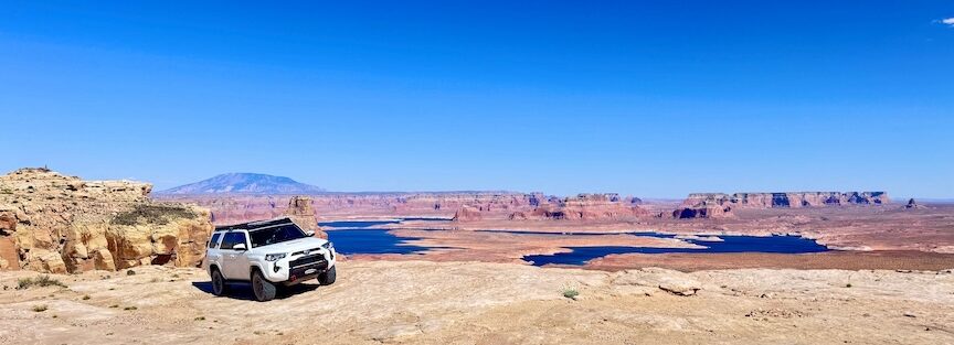
The first stretch from Big Water is typical high-desert BLM road: dusty, occasionally rough, but manageable at a reasonable pace. Rolling desert hills, distant buttes, and the terrain transitions of the Kaiparowits Plateau fill the view as you drive north. The road tests progressively as you approach Alstrom Point: deeper sand, more significant elevation changes, and the rocky drops that require the most careful driving of the route. See the full route guide for Smoky Mountain Road for the corridor context.
The drive itself is part of the experience. The Smoky Mountain Road corridor provides a visual progression from the highway-adjacent high desert near Big Water to the remote canyon country above Lake Powell that functions as a natural preparation for the view at the end. Don’t rush it.
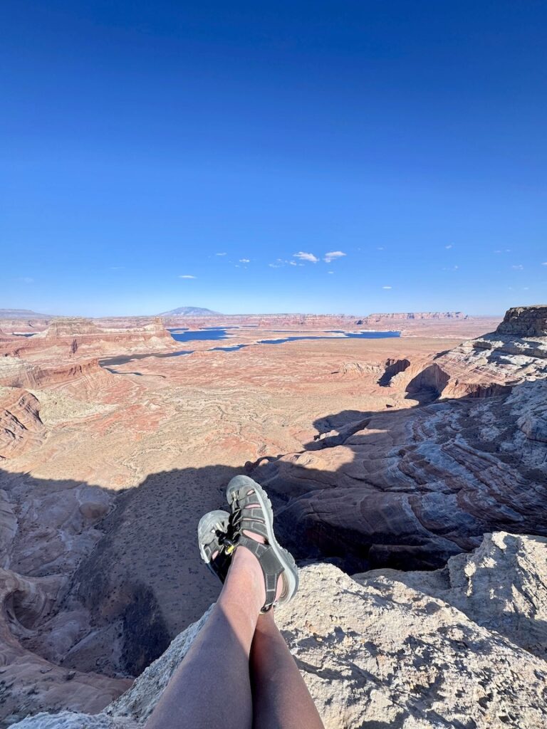
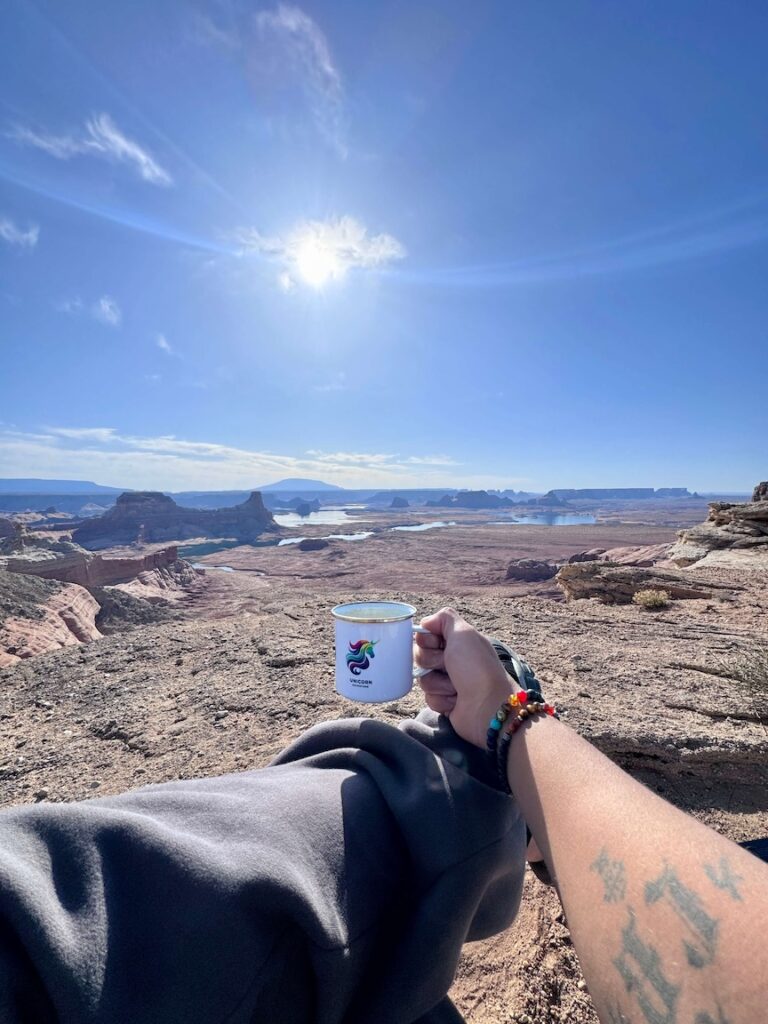
Alstrom Point
At the point, the land drops away in most directions to reveal Lake Powell below. The lake’s winding channels through the sandstone canyon system are visible from multiple angles. On a clear day the canyon country extends to the horizon in every direction, with the buttes and mesas of the Colorado Plateau creating the visual depth that makes this view distinctive.
There are no guardrails and the cliff edges are real. Stay back from the edge and supervise dogs and children closely. The ground is uneven rough rock; watch your footing on the approach to the best view positions.
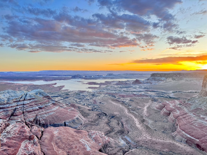
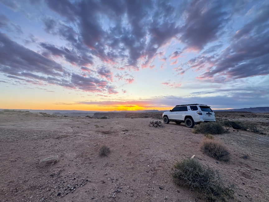
For photography: sunset is the priority timing. The lake catches the orange and pink light of golden hour and the canyon walls turn deep red. The 360-degree view gives you multiple composition directions to work through as the light changes. Sunrise is the less-visited alternative; the pre-dawn drive in the dark requires familiarity with the road or a very early departure. Wide-angle for the panorama, mid-range for the canyon wall and lake detail.
Route Difficulty and Length
The route is approximately 50 miles roundtrip and 3,100 feet of elevation gain for the full Alstrom Point experience. Moderate drive difficulty is accurate for a capable vehicle and experienced driver. The sandy and rocky final miles are the crux. Budget 3-5 hours roundtrip at a careful pace with time at the point; rushing Smoky Mountain Road produces mechanical and recovery problems.
Dog Friendly?
Yes. Dogs are welcome on leash. The open terrain at Alstrom Point is pleasant for dogs after the vehicle ride, but the cliff edges require tight leash management. No shade and no water at the point; bring at least a liter for dogs. The vehicle-based nature of most of the route is comfortable for most dogs if they handle long drives acceptably.
What to Bring
Vehicle recovery gear: tow straps, traction boards, shovel, full-size spare, tire repair kit. Satellite communicator. Water: 3-4 liters per person given the desert heat and the duration. Snacks and food for a half-day or full-day expedition. A blanket or layers for sunset and overnight stays. Headlamp if you’re staying for sunset and driving back in the dark.
For photography: wide-angle for the panorama, mid-range for canyon detail, a tripod for the golden-hour low-light work, and extra memory cards for the volume of compositions the 360-degree view generates.
Camping at Alstrom Point
Camping is permitted at Alstrom Point under Glen Canyon NRA regulations. Fully self-contained means everything in and everything out: no toilets, no water, no facilities. A sunset-to-sunrise camp at Alstrom Point eliminates the need to drive the road in the dark. Given the quality of both sunset and sunrise from this location, overnight stays are worth the logistics for anyone set up for desert camping.
Best Time to Visit Alstrom Point
Spring (March through May) and fall (September through November) are the comfortable windows. Mild daytime temperatures, cooler nights, and the best landscape light of the year make these the prime windows for both the drive and the sunset at the point.
Summer is the heat challenge: Smoky Mountain Road has virtually no shade and the drive in midsummer heat combined with the physical effort of any stuck-vehicle recovery makes summer trips high-risk for people without extensive desert expedition experience. Early morning summer starts (departing Big Water before 6 a.m.) are the practical summer approach.
Never drive Smoky Mountain Road in wet conditions or when rain is forecast. The dirt road becomes impassable mud that can strand vehicles regardless of their capability. Check weather.gov for the Escalante / Kaiparowits region before every visit.
Rules and Regulations
Glen Canyon National Recreation Area rules apply. Stay on designated roads. Do not drive off-road in the surrounding desert terrain. Leave No Trace throughout: pack out everything, leave no fire rings, bury human waste 200 feet from water. Dogs on leash. No drone flight without a special use permit. Camping permitted but fully self-contained required.
Where to Stay Near Big Water or Page
Page, Arizona, is the nearest town with full chain hotel infrastructure, about 15 miles east of Big Water on US-89. Big Water has limited services (gas station, basic supplies). For points travelers, check available Marriott Bonvoy properties in Page, IHG Rewards hotels in Page, and Hilton Honors options in Page. Kanab, Utah, is about 30 miles west.
Nearby Adventures
Crosby Canyon OHV is the other OHV route from the same Big Water / Smoky Mountain Road corridor: a canyon route to a Lake Powell beach about 10-12 miles from Big Water off the same BLM road network. A natural companion route for anyone spending a full day in the area.
The Page, AZ cluster is 15-30 miles east: Horseshoe Bend, Dam Overlook Trail, Glen Canyon Bridge, Hanging Garden Trail, and the Beehive / New Wave formations. An Alstrom Point sunset visit pairs well with a Page morning for the overlook and viewpoints.
Plan This Drive
AllTrails has Alstrom Point via Smoky Mountain Road mapped with GPS track and offline capability. The GPS track is the most important resource for this route given the road junctions and the final approach to the point. Plan your drive on AllTrails and download the full offline map and GPS track before leaving Big Water.
Chase the Quiet
You drive 25 miles of rough road through empty high desert and then the land drops away and there’s Lake Powell below you in every direction and the canyon walls catching the sunset. That view is what the road was built toward, whether or not that was the intention. The roughness of the approach is calibrated to the quality of the destination: the more committed the route, the less crowded the reward. Alstrom Point at sunset with the color on the water and no one else at the edge is a specific and repeatable thing, but you have to do the math on the road to get there.
Support the Adventure
To make your walls less boring, check out my photography portfolio and bring a piece of the wild and my story into your home.
If you’d like to fuel future adventures, you can donate a coffee on Ko-Fi. Every cup keeps me chasing sunrises and stories.
When you shop using my affiliate links, every click helps support this blog at no extra cost to you. It’s a small way to keep Unicorn Adventure alive and kicking while I keep exploring.
Subscribe to my mailing list for future updates, new stories, and behind-the-scenes adventures.
Stay connected with me on Instagram and Facebook for more photos and daily inspiration.
Thanks for being part of the journey, Unicorn Squadron!

Theo Maynard is a landscape photographer and adventure blogger based in Salt Lake City. He chases remote desert and mountain light across the American West, documents it all solo, and shares the journey through Unicorn Adventure. He’s on the autism spectrum, and that’s not a footnote, it’s the whole story. He creates to inspire others to get outside, chase what lights them up, and live their best possible life. Unapologetically himself.