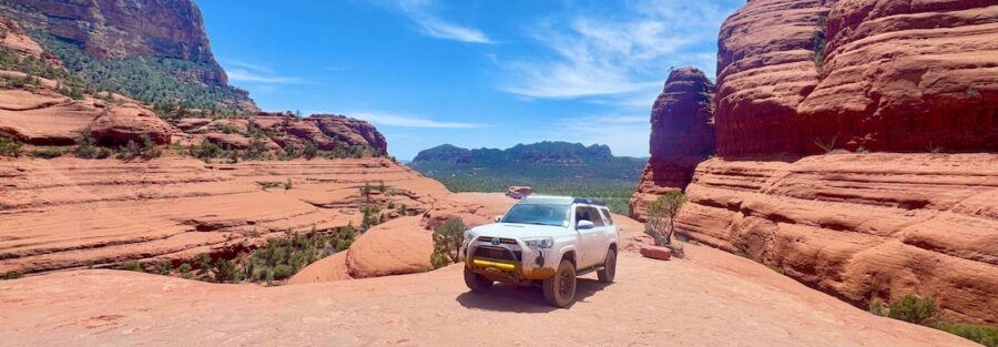
Broken Arrow is 3.5 miles. It takes less than two hours start to finish if you push through. But nobody pushes through Broken Arrow. The route is too good for that. Tight slickrock ledges, steep rock steps, Submarine Rock rising 50 feet off the trail surface, and then Chicken Point, a broad sandstone plateau perched above the canyon with a panoramic view that stops the whole group.
Broken Arrow is one of those drives that demands enough from you that everything else goes quiet. You’re managing the rock steps, reading the terrain, choosing your line. There’s no bandwidth left for anything else. That’s exactly what I want from a trail. Two minutes from AZ-179 and you’re in it.
Quick Facts
Location | Coconino National Forest, Sedona, Arizona |
Coordinates | |
Distance | ~3.5 miles round trip |
Elevation Gain | ~400 ft |
Difficulty | Moderate to Difficult (high-clearance 4WD or capable ATV/UTV required) |
Time | 3 hours depending on stops |
Dogs Allowed | Yes, secured in vehicle only. Trail terrain is not walkable for dogs. |
Fee | Red Rock Pass required for parking ($5/day or $15/week) |
How to Get There
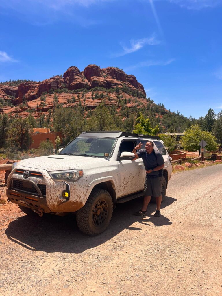
Broken Arrow starts a few minutes from the center of Sedona. From AZ-179, turn east onto Morgan Road. Follow it to the dirt parking area near the Broken Arrow Trailhead. The drive in is short and the trailhead is well-signed during operating hours. No long approach road, no remote canyon to navigate. Park, check your rig, and go.
Note that Broken Arrow is a permitted route and managed access applies. Check current operating status and permit requirements with the Coconino National Forest before heading out, as access restrictions and seasonal closures apply. During peak season, the trail is busy with guided Jeep tours in addition to self-guided vehicles.
Cell Service and Navigation
Coverage at the Broken Arrow Trailhead is solid, you’re close to Sedona. Once on the route, signal drops in the canyon sections. Download the OnX Offroad or Gaia GPS track for Broken Arrow before you leave. The route is short and generally hard to lose, but the rock terrain has multiple vehicle lines on some sections and having a GPS track confirms you’re on the designated corridor. Staying on the permitted route matters here. The Forest Service monitors Broken Arrow actively.
What to Expect on Broken Arrow OHV Route
The Rock Terrain
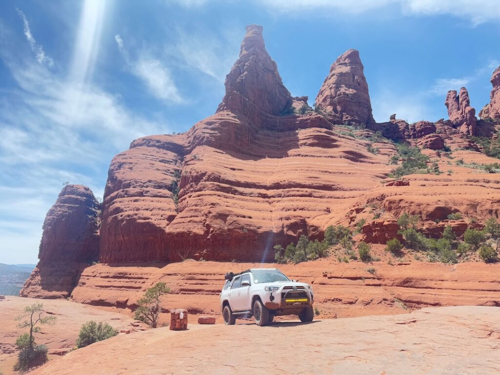
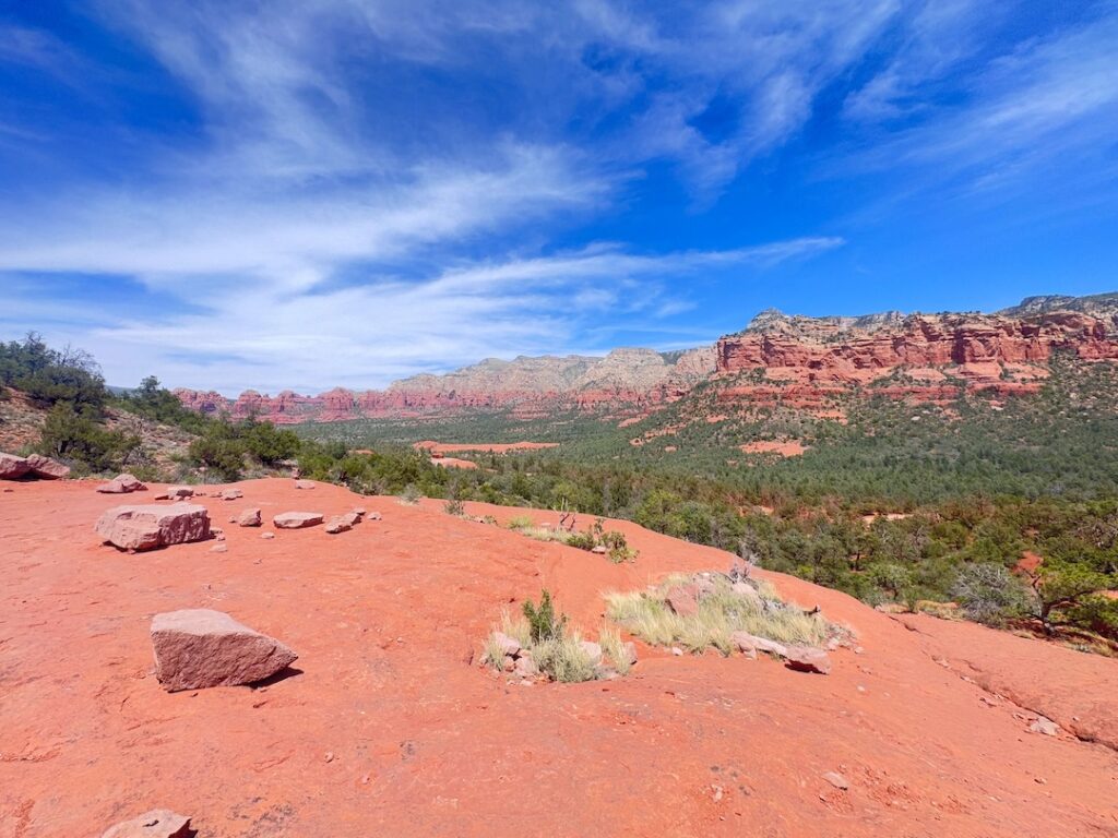
Broken Arrow starts with immediate technical content. Rock ledges, tight turns through juniper, and slickrock ramps appear within the first half mile. The trail weaves through a red rock landscape unlike anything else in the Sedona corridor. Submarine Rock, a massive sandstone formation shaped like its namesake, rises alongside the trail and is the first major landmark. The terrain demands active driving throughout. You’re not cruising this route. You’re picking lines, managing wheel placement, and reading the rock surface constantly.
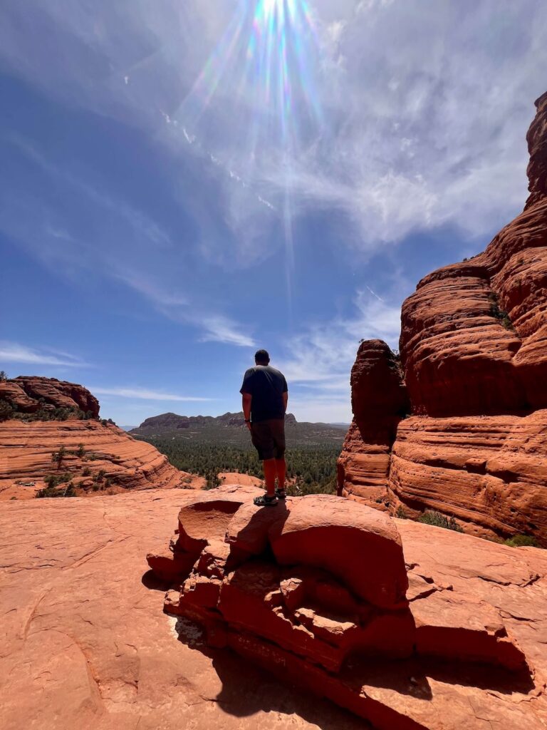
Chicken Point
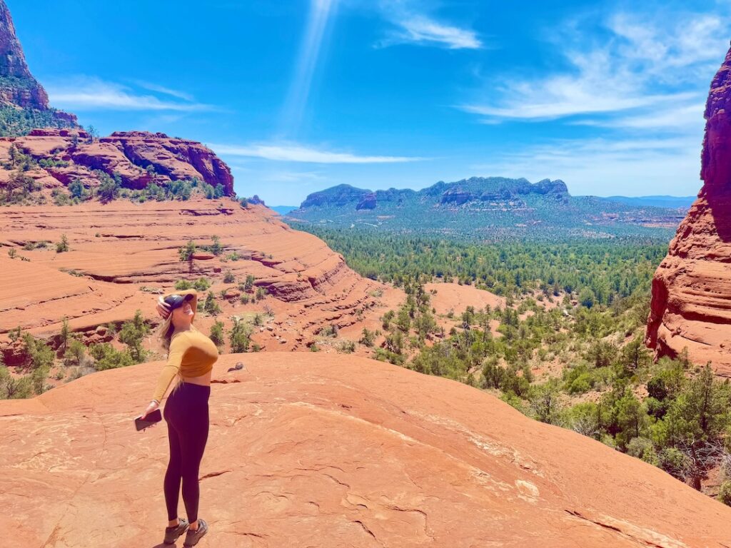
Chicken Point is the destination everyone comes for. It’s a broad, flat sandstone ledge perched above a canyon drop with a panoramic view of the surrounding red rock formations and the Verde Valley beyond. The name comes from the exposed ledge at the edge of the overlook, where the canyon drops away sharply and driving up to the edge requires either confidence or a very careful approach. Most people park before the edge and walk the last few feet. The view from Chicken Point is the best vehicle-accessible overlook in Sedona. Full stop.
The Light
Sunrise and sunset are both exceptional on Broken Arrow. The route faces generally southwest, which means afternoon light works in your favor on the way in from Morgan Road. Chicken Point catches the full golden hour light from the west as the sun drops toward the Verde Valley, and the sandstone formations around the overlook go deep orange before fading. If you can time a Chicken Point stop for 45 minutes before sunset, do it. It’s one of the better photography locations in Sedona that you can reach with a vehicle.
Drive Difficulty and Length
Broken Arrow runs approximately 3.5 miles round trip with around 400 feet of elevation change. The route is rated moderate to difficult. It is not the most technically demanding trail in the Sedona area, but it is not a casual drive either. High-clearance 4WD is required. Capable ATVs and UTVs handle the terrain well. The rock steps and ledge climbs demand low-range gearing. Air down to 18 to 22 PSI before starting for better traction on the slickrock sections. A full-size spare and basic recovery kit are standard preparation on any remote rock trail. If you are new to technical off-road driving, a guided Jeep tour is worth considering before attempting this solo.
Dog Friendly?
Dogs are allowed on Broken Arrow, but only in the vehicle, secured at all times. This is not a walking trail. The rock terrain, steep ledges, and vehicle traffic make it unsafe for dogs on foot. Keep your dog restrained, cool, and hydrated throughout the drive. At Chicken Point, you can let them out on leash in the flat staging area away from the canyon edge. Pack out all waste.
What to Bring
Vehicle prep is the priority: aired-down tires, full-size spare, tow strap, and a basic recovery kit. For yourself: 2 liters of water minimum, sunscreen and a hat for the Chicken Point overlook stop, and a camera. Chicken Point and the Submarine Rock section both reward a wide lens.
Best Time to Drive Broken Arrow
Spring (March through May) and fall (September through November) are the best windows. Mild temperatures, stable road surfaces, and the red rock light at its most dramatic. Summer works with an early start but the exposed slickrock and Chicken Point overlook bake by 10 a.m. Be off the trail before midday in July and August. Winter is possible in Sedona most years, but wet or icy rock is significantly more dangerous on the slickrock sections. Check conditions with the Coconino National Forest before going after any precipitation. The permit and access system at Broken Arrow also affects timing, check current reservation requirements before you plan your visit.
Rules and Regulations
Broken Arrow is a managed OHV route in Coconino National Forest. A Red Rock Pass is required for parking. Stay on the designated route at all times. Broken Arrow is actively monitored by the Forest Service and off-trail vehicle damage results in fines and potential trail closure. All vehicles must be street-legal and registered. Yield to hikers and bikers who use sections of the surrounding trail network. No campfires anywhere on the route. Pack out all waste. The trail’s continued operation depends on the behavior of every driver on it.
Where to Stay Near Sedona
Broken Arrow’s trailhead is minutes from central Sedona, making any Sedona property a convenient base. For points travelers, Marriott Bonvoy covers Sedona and the Verde Valley. IHG Rewards has properties in the region. Hilton Honors covers Sedona-area properties on the AZ-179 and AZ-89A corridors. Uptown Sedona is the most convenient base for trailhead access, food, and galleries. The Village of Oak Creek, five miles south, is a quieter alternative close to Bell Rock and Cathedral Rock.
Camping Nearby
Schnebly Hill Road dispersed camping is the closest free option, 10 minutes from Broken Arrow on Coconino National Forest land. Fox Borough pull-offs offer canyon views and open platforms at no cost with a 14-day limit. Nolan Tank and Edge of the World are additional dispersed sites in the Sedona area. No water or services at any dispersed site. For developed camping, Munds Park campground is further north but offers full amenities.
Nearby Adventures
Bell Rock Trail is a short drive south on AZ-179, the most iconic vortex formation in Sedona with an easy 0.8-mile base loop and a rewarding scramble for those who want to go higher. Munds Wagon, Cow Pies, and Hangover Loop is the hiking counterpart to Broken Arrow’s terrain, 8.2 miles and 1,181 feet of gain through the Cow Pies formations and along the Hangover cliffside ledges. Schnebly Hill Road OHV Route is the longer off-road follow-up at 12 miles and 2,600 feet of gain with Verde Valley rim views. For non-driving Sedona, Slide Rock State Park along Oak Creek Canyon is the best post-trail cool-down in the area, natural water slides in a red rock creek setting. The Chapel of the Holy Cross on AZ-179 is the architectural landmark worth the stop on the way back into town.
Plan This Drive
OnX Offroad provides the most detailed Broken Arrow route coverage with designated trail corridors, terrain data, and condition reports. Gaia GPS also covers this route. Check current permit requirements and access status through the Coconino National Forest website before planning your visit. Explore the area on AllTrails here.
Chase the Quiet
Chicken Point on a weekday morning before the first Jeep tour shows up is a different experience than the midday version. I had the overlook to myself for about 20 minutes on a Tuesday in October. The canyon below was still in shadow, the formations catching the first angled light from the east, the Verde Valley stretching out to the south. Three and a half miles from Morgan Road. That’s how close Sedona keeps something like this.
Support the Adventure
To make your walls less boring, check out my photography portfolio and bring a piece of the wild and my story into your home.
If you’d like to fuel future adventures, you can donate a coffee on Ko-Fi. Every cup keeps me chasing sunrises and stories.
When you shop using my affiliate links, every click helps support this blog at no extra cost to you. It’s a small way to keep Unicorn Adventure alive and kicking while I keep exploring.
Subscribe to my mailing list for future updates, new stories, and behind-the-scenes adventures.
Stay connected with me on Instagram and Facebook for more photos and daily inspiration.
Thanks for being part of the journey, Unicorn Squadron!

Theo Maynard is a landscape photographer and adventure blogger based in Salt Lake City. He chases remote desert and mountain light across the American West, documents it all solo, and shares the journey through Unicorn Adventure. He’s on the autism spectrum, and that’s not a footnote, it’s the whole story. He creates to inspire others to get outside, chase what lights them up, and live their best possible life. Unapologetically himself.