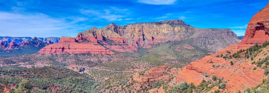
The Hangover Trail gets its name honestly. It runs along a narrow ledge carved into the face of a red sandstone cliff, with the canyon floor a few hundred feet straight down and nothing between you and it except your own footing. It is exposed, dramatic, and completely worth every nerve-jangling step. Combined with the historic Munds Wagon Road and the surreal flat-rock landscape of the Cow Pies, this 8.2-mile loop delivers more variety per mile than just about anything else on the Sedona trail map.
Quick Facts
|
Location |
Coconino National Forest, Sedona, Arizona |
|
Coordinates |
|
|
Distance |
8.2 miles (loop) |
|
Elevation Gain |
1,181 ft |
|
Difficulty |
Moderate to Strenuous |
|
Time |
6 hours |
|
Dogs Allowed |
Partial. Dogs allowed on Munds Wagon and Cow Pies segments. Not recommended on Hangover Trail. |
|
Fee |
Red Rock Pass required ($5/day or $15/week) |
How to Get There
The Schnebly Hill Trailhead is the standard starting point. From central Sedona, take AZ-179 south and turn left onto Schnebly Hill Road. The road is unpaved and rocky after the first mile, requiring a high-clearance vehicle for the full 4-mile drive to the upper trailhead. If you’re in a standard vehicle, park at the lower end and hike up Schnebly Hill Road to reach the loop. The Midgley Bridge parking area off AZ-89A is an alternative access point, but it adds extra mileage before you reach the loop proper.
Parking Information
Parking at the Schnebly Hill Trailhead requires a Red Rock Pass: $5 for a day pass or $15 weekly. The lot is small and fills early on weekends. Arrive before 8 a.m. or plan to hike in from lower on Schnebly Hill Road. Midgley Bridge has more parking but adds distance. Passes are available at kiosks at the trailhead or online before you leave.

Cell Service and Navigation
Cell service on Schnebly Hill Road drops in and out as you climb away from Sedona. On the upper trail sections and along the Hangover ledges, signal is unreliable across all carriers. Download your maps before you leave. AllTrails and Gaia GPS both cover this loop with good detail. The Hangover Trail segment in particular has a few route-finding moments where a loaded GPS track helps. Do not rely on real-time navigation once you’re on the upper trail.
What to Expect on Munds Wagon, Cow Pies, and Hangover Loop
Munds Wagon Road
The loop begins on the historic Munds Wagon Road, a rugged track used by pioneers and ranchers moving between Sedona and Flagstaff in the late 1800s. The road climbs steadily through red rock terrain with towering cliffs building on both sides. It’s the most straightforward section of the loop, a wide dirt track with manageable grades. History runs underneath your boots the whole way, which is not a bad feeling.
The Cow Pies
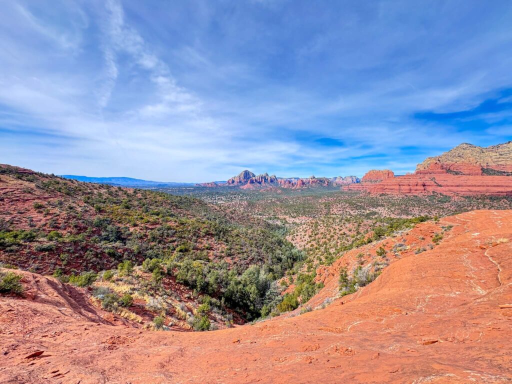
Midway through the loop, the terrain opens onto the Cow Pies, a broad plateau of flat, rounded sandstone slabs shaped by erosion into formations that genuinely resemble what the name implies. The flat rock surface makes for easy walking and the views open up completely. Cathedral Rock, Bell Rock, and Courthouse Butte fill the southern horizon. Oak Creek Canyon drops away to the north. It’s one of the best open-sky viewpoints on any Sedona trail, and a good place to stop, eat something, and look around before the Hangover section starts.
Hangover Trail
The Hangover Trail is the reason most people run this loop. It traverses a narrow ledge system carved along the face of the red rock cliffs, hanging over the canyon with exposure on the outer edge for most of its length. The trail is not technical climbing, but it demands real attention. Footing on the sandstone varies from solid to loose. Some sections are narrow enough that passing another hiker requires care. The drop-offs are significant and there are no barriers. If you have a serious fear of heights, this section will test you. If you have a moderate one, it will push you. Either way, the views from the ledges are the best on the entire loop, panoramic canyon walls in every direction, with Sedona’s full red rock basin laid out below.

Trail Difficulty and Length
The full loop is 8.2 miles with 1,181 feet of elevation gain. The difficulty rating sits at moderate to strenuous depending on your comfort with exposure. The Munds Wagon and Cow Pies sections are solidly moderate. The Hangover Trail pushes it toward strenuous, not because of the physical demand but because of the mental focus required on exposed ledges with significant drop-offs. This is not a trail for beginners or anyone uncomfortable with heights. Sturdy hiking boots with ankle support and good grip are non-negotiable. Trekking poles help on the descent. Give yourself 4 to 6 hours and don’t rush the Hangover section.
Dog Friendly?
Partially. Dogs are allowed on the Munds Wagon and Cow Pies segments of the loop. The Hangover Trail is not recommended for pets. The exposed ledges, narrow sections, and significant drop-offs are genuinely dangerous for dogs, and the rough sandstone is hard on paws over extended exposed terrain. If you want to bring your dog, plan a modified route that avoids the Hangover section, or save this one for a solo trip.
What to Bring
Bring 3 liters of water minimum for this loop. There is no water on the trail and 8.2 miles in Sedona’s desert climate adds up fast. Sunscreen, a hat, and sunglasses for the exposed Cow Pies plateau and Hangover ledges. Hiking boots with real ankle support and aggressive grip, both for the rocky Munds Wagon climb and the sandstone ledges on Hangover. Trekking poles are worth carrying for the descent. Snacks for the Cow Pies overlook, it’s the best lunch spot on the loop.
Best Time to Hike Munds Wagon, Cow Pies, and Hangover Loop
Fall (October through November) and spring (March through April) are the best windows, temperatures in the 60 to 80 degree range and the red rock light at its most dramatic. Summer is possible but demands a pre-dawn start. The Cow Pies plateau and Hangover ledges have zero shade, and Sedona summer afternoons push well past 100 degrees. Sunrise on the Hangover ledges is exceptional, golden light hitting the canyon walls from the east while the valley below is still in shadow. That’s the shot. Plan to reach the Hangover section about 45 minutes after first light for the best conditions.
Rules and Regulations
The Munds Wagon, Cow Pies, and Hangover Loop sits within Coconino National Forest. Stay on designated trails. The Hangover Trail has a defined route and wandering off it onto the surrounding cliff face is both dangerous and damaging to fragile desert crust. No graffiti. Pack out everything you carry in. No campfires. No drones. No rock, plant, or artifact collection. The combination of high traffic and exposed terrain here makes following these rules more important than on most Sedona trails.
Where to Stay Near Sedona
Sedona has properties from full resort luxury to boutique inns along AZ-89A. For points travelers, Marriott Bonvoy covers Sedona and the Verde Valley. IHG Rewards has properties in the broader region. Hilton travelers can search options through Hilton Honors. Staying in Uptown Sedona or near the Village of Oak Creek puts you closest to the AZ-179 corridor and the Schnebly Hill Road turnoff for an early morning start.
Camping Nearby
Schnebly Hill Road itself has dispersed camping pull-offs on Coconino National Forest land, free with a 14-day limit and no services. The Fox Borough area near the start of Schnebly Hill is a solid option with canyon views and space for multiple rigs. Nolan Tank and Edge of the World are two more free dispersed sites in the greater Sedona area. Bring all your own water, food, and gear. No hookups, no facilities at any dispersed site.
Nearby Adventures
Devil’s Bridge Trail is the most iconic single destination in Sedona, the largest natural sandstone arch in the area at 3.9 miles and 521 feet of gain. Boynton Canyon is a full-day 6.5-mile moderate hike with a vortex, the Subway Cave, and ancient ruins. Fay Canyon is the low-key counterpart to all three, 2.4 miles and 298 feet of gain with a hidden arch and solid canyon shade. For Sedona’s non-trail side, the Chapel of the Holy Cross is a must: an architectural landmark built into the cliff face on AZ-179 with sweeping red rock views. Tlaquepaque Arts and Shopping Village is the best post-hike stop for food, local art, and a cold drink after a demanding trail day.
Plan This Hike
AllTrails has the full Munds Wagon, Cow Pies, and Hangover Loop documented with GPS tracking, elevation profiles, and user reviews that flag current conditions on the Hangover ledges after rain. Download the offline map before you leave, the route-finding on the upper sections benefits from having a GPS track running. Plan your hike on AllTrails here.
Chase the Quiet
There’s a section on the Hangover Trail where the ledge narrows to about 18 inches and the canyon drops straight down for 400 feet off your left shoulder. I stopped there for a minute on the way around. Not because I was scared, just because it felt important to acknowledge where I was. Standing on a notch of sandstone above Sedona’s full red rock basin, completely alone, with Cathedral Rock rising across the canyon and the morning light still low and warm. That is the kind of moment that makes the 8 miles make sense.
Support the Adventure
To make your walls less boring, check out my photography portfolio and bring a piece of the wild and my story into your home.
If you’d like to fuel future adventures, you can donate a coffee on Ko-Fi. Every cup keeps me chasing sunrises and stories.
When you shop using my affiliate links, every click helps support this blog at no extra cost to you. It’s a small way to keep Unicorn Adventure alive and kicking while I keep exploring.
Subscribe to my mailing list for future updates, new stories, and behind-the-scenes adventures.
Stay connected with me on Instagram and Facebook for more photos and daily inspiration.
Thanks for being part of the journey, Unicorn Squadron!

Theo Maynard is a landscape photographer and adventure blogger based in Salt Lake City. He chases remote desert and mountain light across the American West, documents it all solo, and shares the journey through Unicorn Adventure. He’s on the autism spectrum, and that’s not a footnote, it’s the whole story. He creates to inspire others to get outside, chase what lights them up, and live their best possible life. Unapologetically himself.