Schnebly Hill Road starts two miles south of Sedona and ends at I-17. In between, it climbs 2,600 feet through red sandstone canyon walls, past the Cow Pies rock formations, up to a rim overlook with the full Verde Valley spread out below, and then into ponderosa pine forest before it drops you back onto pavement. Twelve miles, no guardrails, and views that stop you in your tracks every quarter mile. It is one of the best drives in Arizona and most people passing through Sedona never take it.
Quick Facts
Location | Coconino National Forest, Sedona, Arizona |
Coordinates | Sedona start: 34.8622, -111.7614 | I-17 end: 34.9119, -111.6432 |
Distance | ~12 miles (one way, Sedona to I-17) |
Elevation Gain | ~2,600 ft |
Difficulty | Moderate (high-clearance 4WD required) |
Time | 4 hours depending on stops |
Dogs Allowed | Yes, secured in vehicle. Vista areas allow leashed dogs on foot. |
Fee | No permit required for the road; Red Rock Pass may be required at trailhead parking areas |
How to Get There
Schnebly Hill Road starts off AZ-179, a few miles south of Sedona’s main corridor. From downtown Sedona, take AZ-179 south. Look for Schnebly Hill Road on your left. The road begins paved and transitions to dirt and rock within the first half mile, at which point the terrain makes clear this is not a route for standard passenger vehicles. The road runs 12 miles northeast and terminates at I-17 near Flagstaff.
You can drive it in either direction. Sedona to I-17 is the more common approach, climbing gradually through the canyon before cresting the rim. I-17 to Sedona puts you descending into the red rock basin, which gives a different perspective but can feel steeper on the back end. Either direction works. Just don’t attempt it in a stock sedan or low-clearance SUV.

Cell Service and Navigation
Cell service drops out within the first mile of leaving Sedona on Schnebly Hill Road. Coverage comes back near the I-17 end. Verizon holds slightly better than AT&T on the upper sections, but don’t count on either. Download offline maps before you leave. Gaia GPS and OnX Offroad both cover Schnebly Hill Road with road surface data and elevation profiles. The route is a single road from Sedona to I-17, so navigation is straightforward, but having a GPS track running is useful for identifying named formations and the vista overlook.
What to Expect on Schnebly Hill Road
The Lower Canyon
The first few miles climb steadily through red sandstone canyon walls that build quickly on both sides. The Cow Pies formations appear early, the same rounded flat rock slabs you’ll see on the Munds Wagon hiking loop nearby, here visible from the road and accessible with a short walk from a pull-off. Mitten Ridge frames the canyon to the north. The road surface is rough but manageable in these lower miles, rocky with ruts that deepen after rain but stay passable for a capable rig in dry conditions.
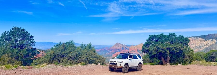
Schnebly Hill Vista
About midway up, the road crests a broad overlook above the red rock canyon. Schnebly Hill Vista is the main photographic stop on the route. The Verde Valley opens below you and the full scope of Sedona’s red rock basin becomes visible: Cathedral Rock, Bell Rock, Courthouse Butte, and the canyon systems running south toward Cottonwood. This is also listed as a vortex site by Sedona’s spiritual community. Whether or not that resonates with you, the location has a quality of stillness that is genuinely unusual. Worth at least 20 minutes.

The Upper Road and Pines
Above the vista, the terrain shifts. The red sandstone gives way to ponderosa pine forest as the elevation climbs toward the Mogollon Rim. The road narrows and the incline steepens on the upper sections. These miles are more demanding than the lower canyon, with sharper rocks, tighter turns, and sections that require real low-range driving after wet weather. The contrast between the red rock below and the dark green pines above is one of the best visual transitions on any drive in the state.
Drive Difficulty and Length
Schnebly Hill Road runs approximately 12 miles one way with around 2,600 feet of elevation gain from the Sedona end. High-clearance 4WD is required. The road is rated moderate for experienced off-road drivers in capable vehicles. After rain it moves to difficult, with deep ruts and slick clay sections that will trap unprepared rigs. Air down to 18 to 22 PSI before you start. Carry a full-size spare, tow strap, and traction boards. The road sees enough traffic that you’re unlikely to be stranded alone, but self-sufficiency matters on a 12-mile remote route with no cell service.

Dog Friendly?
Dogs are allowed on Schnebly Hill Road. Keep them secured in the vehicle during the drive. The rough terrain and constant movement is stressful for unsecured animals. At pull-offs and the vista overlook, leashed dogs can get out and stretch. The vista area has some sharp rock edges and cacti near the overlook, keep your dog close. Bring water from home. No sources along the road. Pack out all waste.
What to Bring
Vehicle prep first: full tank of gas, aired-down tires, full-size spare, tow strap, traction boards, basic recovery kit. For yourself: 3 liters of water per person, snacks for the vista stop, sunscreen and a hat for the exposed overlook, and layers since the upper pine section runs noticeably cooler than Sedona below. A camera is non-negotiable. The canyon formations in the lower miles and the vista panorama in the middle both reward a wide lens.

Best Time to Drive Schnebly Hill Road
Late spring through fall is the reliable window, May through October. The road is usually passable year-round but snow and ice can close the upper sections from December through February. Monsoon season (July through mid-September) brings afternoon storms that wash out sections and leave the clay impassable for days. Check conditions with the Coconino National Forest Flagstaff Ranger District before going in monsoon season. Late afternoon from the Sedona end gives you the best light: the setting sun hits the red rock formations from the west and the whole canyon glows for the hour before dark. That’s the shot.
Rules and Regulations
Schnebly Hill Road is a designated Coconino National Forest route. Stay on the road. Off-road driving outside the designated corridor damages desert vegetation and soil that takes decades to recover. All vehicles must be street-legal and registered. ATVs and UTVs are permitted on this route, unlike some other Coconino Forest roads. Fire restrictions apply seasonally, check current status with the Forest Service before any campfire. No camping at the vista overlook or roadside pull-offs marked no camping. Pack out all waste. The road is a shared resource for hikers, bikers, and drivers.
Where to Stay Near Sedona
Sedona’s lodging ranges from full resort luxury to budget-friendly properties along AZ-89A. For points travelers, Marriott Bonvoy covers Sedona and the Verde Valley. IHG Rewards has properties in the region. Hilton Honors covers Hampton Inn and other options near Sedona. Staying in the Village of Oak Creek or Uptown Sedona both put you close to the AZ-179 Schnebly Hill Road turnoff. Flagstaff at the I-17 end is a full-service city with solid lodging options if you’re running the road north to south.
Camping Nearby
Schnebly Hill Road itself has dispersed camping pull-offs on Coconino National Forest land. The Fox Borough area near the Sedona start (34.8981, -111.6689) is the most established, with platforms and canyon views, free with a 14-day limit. Nolan Tank and Edge of the World are additional Sedona-area dispersed options. No water, no hookups, no services at any dispersed site. The upper pine forest sections of Schnebly Hill Road also have dispersed pull-offs once you’re past the vista, quieter and cooler than the canyon sites below.
Nearby Adventures
Munds Wagon, Cow Pies, and Hangover Loop is the hiking counterpart to this drive, 8.2 miles and 1,181 feet of gain through the same Cow Pies terrain and along the Hangover cliffside ledges. Devil’s Bridge Trail is Sedona’s most iconic hike at 3.9 miles and 521 feet of gain to the largest natural sandstone arch in the area. Boynton Canyon Trail adds the vortex, Subway Cave, and ancient ruins at 6.5 miles and 918 feet of gain. For non-hiking Sedona, the Chapel of the Holy Cross on AZ-179 is the landmark architectural stop. The Cowboy Club in Uptown Sedona is a solid post-drive dinner option if you’re coming back into town from the Sedona end.
Plan This Drive
OnX Offroad and Gaia GPS provide the most detailed coverage of Schnebly Hill Road, including road surface conditions, pull-off locations, and elevation data. AllTrails documents some of the connecting hiking routes in the area. For current road conditions, contact the Coconino National Forest Flagstaff Ranger District before heading out, especially after recent rain or in shoulder season. Explore the area on AllTrails here.
Chase the Quiet
The Schnebly Hill Vista stop, halfway up the road, is one of those places I keep coming back to. The Verde Valley below, the red rock basin behind you, the road still ahead and the pines still to come. It’s one of the better in-between places I know, not the start, not the finish, just a moment in the middle of the drive where you can see exactly where you’ve been and where you’re going. I drank a cup of Jetboil coffee up there on a cold October morning and watched the cloud shadows move across the canyon. That’s a good hour.
Support the Adventure
To make your walls less boring, check out my photography portfolio and bring a piece of the wild and my story into your home.
If you’d like to fuel future adventures, you can donate a coffee on Ko-Fi. Every cup keeps me chasing sunrises and stories.
When you shop using my affiliate links, every click helps support this blog at no extra cost to you. It’s a small way to keep Unicorn Adventure alive and kicking while I keep exploring.
Subscribe to my mailing list for future updates, new stories, and behind-the-scenes adventures.
Stay connected with me on Instagram and Facebook for more photos and daily inspiration.
Thanks for being part of the journey, Unicorn Squadron!

Theo Maynard is a landscape photographer and adventure blogger based in Salt Lake City. He chases remote desert and mountain light across the American West, documents it all solo, and shares the journey through Unicorn Adventure. He’s on the autism spectrum, and that’s not a footnote, it’s the whole story. He creates to inspire others to get outside, chase what lights them up, and live their best possible life. Unapologetically himself.