Boynton Canyon doesn’t ease you in. The trail pulls you from dusty parking lot to towering sandstone walls in minutes, and from there it just keeps delivering. Red cliffs, ponderosa pines, a vortex that people drive across the country to stand inside, and if you know where to look, a hidden cave with ancient ruins tucked into the rock.
Quick Facts
|
Location |
Sedona, Arizona |
|
Coordinates |
|
|
Distance |
6.5 miles (out and back) |
|
Elevation Gain |
918 ft |
|
Difficulty |
Moderate |
|
Time |
4 hours |
|
Dogs Allowed |
Yes, on leash |
|
Fee |
Red Rock Pass required ($5/day or $15/week) |
How to Get There
Boynton Canyon Trailhead sits about 20 minutes northwest of downtown Sedona. Take AZ-89A west from Sedona and turn right onto Dry Creek Road. Follow it as it becomes Boynton Pass Road, then turn left onto Boynton Canyon Road. The trailhead is at the end of that road, just outside the Enchantment Resort entrance. The drive is entirely paved and easy to navigate. You’ll see the canyon walls rising ahead of you before you even park.

Parking Information
Parking at the Boynton Canyon Trailhead is free, but the lot fills up fast on weekends and holidays. Arrive before 8 a.m. on busy days or go on a weekday. If the main lot is full, overflow parking at the nearby Fay Canyon Trailhead is a short walk away. You’ll need a Red Rock Pass to park, either $5 for a day pass or $15 for a weekly pass. Purchase at kiosks near the trailhead or online before you leave.
Cell Service and Navigation
Verizon and AT&T both carry solid coverage in the Sedona area, but deep in the canyon you may lose signal. Download offline maps before you leave. AllTrails, Gaia GPS, and Google Maps offline all work well here. The trail is well-marked and hard to lose, but having a backup never hurts, especially if you’re hunting for the Subway Cave or planning the scramble to the ruins.

What to Expect on Boynton Canyon
The Trail
The trail starts wide and sandy, working through juniper scrub and ponderosa pine as the canyon walls build on both sides. Early on you’ll have open views of Bear Mountain and Doe Mountain flanking the mouth of the canyon. The path shifts between packed dirt and loose rock as you push deeper. It’s well-maintained and easy to follow the whole way.

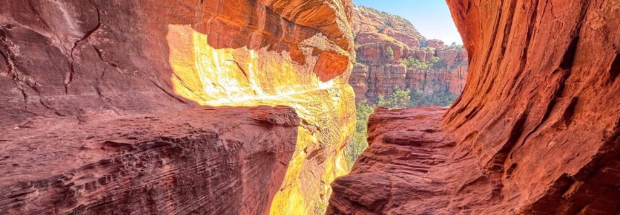
The Subway Cave
About halfway in, the Subway Cave appears on the canyon wall to your right. It’s easy to walk past if you’re moving fast. Slow down and look. The cave is a natural alcove with a curved, arch-like ceiling that creates a tunnel effect and gives the spot its name. Midday is actually great for photos here. Sunlight angles into the opening and lights up the interior in a way that’s hard to replicate at any other time. Step inside and look back at the canyon framing the entrance. Worth every minute.
The Ruins
The main trail ends at a viewpoint overlooking the canyon floor and the cliffs above. From there, a short but steep scramble leads up to a hidden cave with ancient ruins tucked into the rock face. The scramble is exposed in spots, so take your time and watch your footing. The ruins themselves are fragile and federally protected. Look, photograph, appreciate. Don’t touch. The views from up there are the best on the trail, panoramic canyon walls in every direction.

Trail Difficulty and Length
Boynton Canyon runs 6.5 miles round trip with 918 feet of elevation gain. Most of the trail is moderate, gradually inclining with manageable footing throughout. The final scramble to the ruins is the hardest section. It’s steep and rocky but short. Solid hiking boots with ankle support and good grip make a real difference here. The main trail is well-marked and accessible for most fitness levels.
Dog Friendly?
Yes. Dogs are welcome on Boynton Canyon Trail. Keep them on leash the entire time. The sandy path is easy on paws, and the canyon shade keeps temperatures cooler than exposed Sedona trails. Bring extra water for your dog. Watch the edges of the trail for prickly pear cactus. Pack out all dog waste. The trail sees heavy foot traffic, so being a responsible dog owner goes a long way here.
What to Bring
Bring at least 2 to 3 liters of water per person. Sedona is desert, and the sun is relentless on the exposed sections. Sunscreen, a hat, and sunglasses cover the open stretches. Hiking boots or trail shoes with good grip matter most near the ruins scramble. Bring snacks for the overlook. A camera or phone with a solid camera is worth every bit of the weight.
Best Time to Hike Boynton Canyon
Fall (October through November) and spring (March through April) are the sweet spots. Temperatures run between 60 and 80 degrees, the crowds thin, and the light is stunning. Summer is hot but the canyon shade helps. Start early regardless of season. Sunrise lights the canyon walls in orange and pink and makes every photo look like a postcard. Sunset turns the sandstone electric gold and draws photographers from across the trailhead. If you can, come twice and shoot both.
Rules and Regulations
Boynton Canyon sits within the Coconino National Forest and Red Rock–Secret Mountain Wilderness. Stay on the designated trail. The desert vegetation along the edges is fragile and slow to recover from foot traffic. The ruins at the canyon end are protected cultural and historical sites. Do not touch, climb on, or remove anything from the ruins. Pack out everything you bring in, including food wrappers and dog waste. No rock collecting. No campfires. No drones. These rules exist to keep Boynton Canyon intact for every hiker who comes after you.
Where to Stay Near Sedona
Sedona stacks up options from full resort luxury to charming roadside character. The Enchantment Resort sits right at the trailhead and is as dramatic as the canyon surrounding it. For Marriott points travelers, the Marriott Bonvoy portfolio covers Sedona and the greater Verde Valley area. IHG members can search the IHG Rewards portfolio for nearby properties. Hilton travelers can browse Sedona-area options through Hilton Honors. Uptown Sedona puts you close to trailheads, food, and art galleries, and it’s the most central base for exploring the red rock country.
Camping Nearby
Sedona’s dispersed camping options sit within easy distance of Boynton Canyon. Schnebly Hill Road has established dispersed pull-offs with canyon views and solid high-clearance access. The Fox Borough area along Schnebly Hill Road is a good starting point, with a mix of open platforms and tree cover. Nolan Tank and Edge of the World are two more dispersed options in the area, both accessible with GPS coordinates and an offline map. All three are free BLM or Coconino National Forest dispersed sites with a 14-day limit. No services, no hookups, and no crowds.
Nearby Adventures
Sedona has trails for every level and mood. Fay Canyon Trail is shorter and family-friendly, with a hidden arch worth hunting for at 2.4 miles and 298 feet of gain. Devil’s Bridge is the largest natural sandstone arch in the Sedona area and the most photographed formation around, 3.9 miles and 521 feet of gain. The Munds Wagon, Cow Pies and Hangover Loop stretches to 8.2 miles with 1,181 feet of gain for hikers who want a real workout. Beyond the trails, the Chapel of the Holy Cross is a stunning architectural landmark built directly into the red rock cliffs overlooking the valley. Tlaquepaque Arts and Shopping Village is the best stop in Sedona for local art, food, and wandering after a long day out. The drive through Oak Creek Canyon on AZ-89A is one of the finest canyon drives in the state and worth doing on the way in or out of Sedona.
Plan This Hike
AllTrails has Boynton Canyon Trail well-documented with GPS tracking, current conditions, and real user reviews from recent hikers. Download the trail map for offline use before you leave, which covers the main route, the Subway Cave waypoint, and the scramble to the ruins. Plan your hike on AllTrails here.
Chase the Quiet
Boynton Canyon is one of those trails that reminds you why you drove all the way out here. The vortex gets most of the attention, and sure, there’s something to standing at the canyon end with 300-foot walls rising on both sides and complete silence below them. But what got me was the ruins. Tucked into a crack in the cliff at the end of a short scramble, those ancient stones have been sitting there for centuries. Somebody built something real and lasting in one of the most beautiful places on earth. That still lands every time.
Support the Adventure
To make your walls less boring, check out my photography portfolio and bring a piece of the wild and my story into your home.
If you’d like to fuel future adventures, you can donate a coffee on Ko-Fi. Every cup keeps me chasing sunrises and stories.
When you shop using my affiliate links, every click helps support this blog at no extra cost to you. It’s a small way to keep Unicorn Adventure alive and kicking while I keep exploring.
Subscribe to my mailing list for future updates, new stories, and behind-the-scenes adventures.
Stay connected with me on Instagram and Facebook for more photos and daily inspiration.
Thanks for being part of the journey, Unicorn Squadron!

Theo Maynard is a landscape photographer and adventure blogger based in Salt Lake City. He chases remote desert and mountain light across the American West, documents it all solo, and shares the journey through Unicorn Adventure. He’s on the autism spectrum, and that’s not a footnote, it’s the whole story. He creates to inspire others to get outside, chase what lights them up, and live their best possible life. Unapologetically himself.