Not every Sedona hike needs to be a production. Fay Canyon is 2.4 miles, easy terrain, a shaded canyon corridor with red rock walls closing in on both sides, and a hidden arch that most hikers walk right past. It’s the kind of trail you can run in an hour, or slow down and spend two hours in, depending on what you need from the day.
Quick Facts
|
Location |
Coconino National Forest, Sedona, Arizona |
|
Coordinates |
|
|
Distance |
2.4 miles (out and back) |
|
Elevation Gain |
298 ft |
|
Difficulty |
Easy |
|
Time |
2 hours |
|
Dogs Allowed |
Yes, on leash |
|
Fee |
Red Rock Pass required ($5/day or $15/week) |
How to Get There
Fay Canyon sits about 20 minutes northwest of downtown Sedona in Coconino National Forest. Take AZ-89A west from Sedona and turn right on Dry Creek Road. Follow it as it becomes Boynton Pass Road. Continue about two miles and look for the Fay Canyon Trailhead on your left. The drive is paved the entire way. The trailhead is signed and easy to find. If you hit the Enchantment Resort entrance, you’ve gone just past it.
Parking Information
The Fay Canyon Trailhead has a dedicated lot that’s free to use but requires a Red Rock Pass: $5 for a day pass or $15 weekly. Purchase at the kiosk at the lot or online before you leave. The lot is spacious but fills up fast on weekend mornings. Arrive before 8 a.m. on busy days or go on a weekday. Overflow parking at the Boynton Canyon Trailhead is a short walk away if Fay Canyon is full.

Cell Service and Navigation
Verizon and AT&T carry solid coverage on Boynton Pass Road and at the trailhead. Coverage holds well throughout this trail since Fay Canyon is relatively shallow and close to Sedona proper. Download an offline map anyway. AllTrails and Gaia GPS both cover this route. The trail is straightforward and hard to lose, but the spur to the hidden arch is unmarked and easy to miss without a waypoint loaded.
What to Expect on Fay Canyon
The Trail
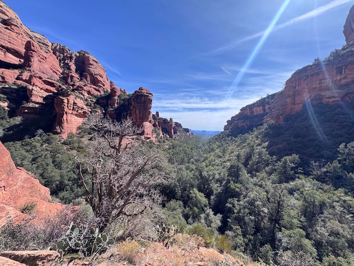
Fay Canyon starts wide and flat, a packed dirt path through juniper and scrub oak with Bear Mountain and Doe Mountain framing the canyon entrance. The walls build quickly. Within the first half mile you’re moving through a defined canyon corridor with 300-foot sandstone cliffs rising on both sides and a canopy of trees overhead that cuts the sun and keeps the canyon 10 to 15 degrees cooler than exposed Sedona trails. The path stays easy the whole way, minimal rock, no steep pitches, good footing throughout.
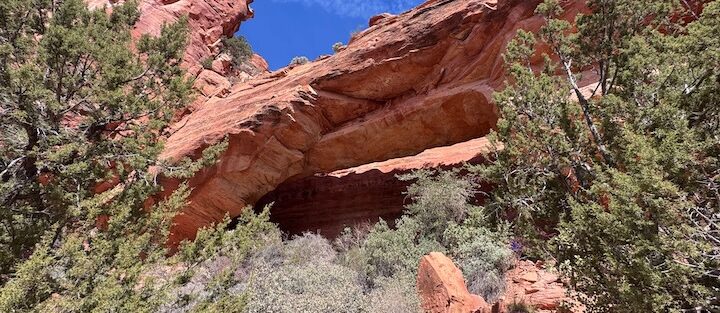
The Hidden Arch
About halfway through the canyon, a faint use-trail branches right and heads upslope into the rocks. That’s the arch spur, and it is genuinely easy to walk past if you’re not watching for it. The scramble up is short, maybe 100 feet of climbing on loose rock, nothing technical. The arch itself is tucked into an alcove in the cliff wall, a curved opening in the red sandstone that frames the canyon below it. The view back through the arch looking out at the canyon floor is the shot. Bring a camera and take your time up there. Most people who hit the main trail never find this spot.
The Canyon End
The main trail terminates at a natural box canyon wall where the terrain closes off. It’s a quiet dead end with good views back down the canyon corridor and the red cliffs overhead. A solid rest stop before the return. Some hikers turn around before the end, which is fine, the canyon is the destination at any point along it.
Trail Difficulty and Length
Fay Canyon is 2.4 miles round trip with 298 feet of elevation gain. It is genuinely easy, appropriate for young kids, older hikers, and anyone recovering from something harder. The main trail is flat and well-maintained. The arch spur is the only section that asks anything of you, loose footing on the scramble up, nothing that requires hands but worth taking slowly. Comfortable trail shoes are fine. The shade means you can hike this midday in summer without the sun hammering you the whole way.
Dog Friendly?
Fay Canyon is one of the better dog hikes in Sedona. Leash required the full time. The canyon shade keeps it cooler than most area trails, the sandy path is easy on paws, and the low mileage makes it manageable for dogs of any age or size. The arch scramble is the only section worth thinking twice on with a dog, steep enough to be awkward for smaller breeds. Bring plenty of water regardless of season and pack out all waste.
What to Bring
The canyon shade makes this one of Sedona’s more forgiving hikes, but bring at least a liter of water per person. Sunscreen and a hat for the open sections at the trailhead and canyon entrance. Comfortable trail shoes or light hikers cover the main trail fine. Grippy soles matter on the arch scramble. Bring a camera. The arch framing the canyon is a strong composition if you hit it with good light.
Best Time to Hike Fay Canyon
Fay Canyon works year-round. Spring (March through April) is ideal, wildflowers come through the canyon floor and the light on the red walls is warm and rich. Fall (October through November) matches that with cooler temperatures and less foot traffic. Summer is actually manageable here because of the shade, just start before 9 a.m. and you’ll be fine on all but the hottest days. The canyon runs east to west, so morning light illuminates the north wall and afternoon light hits the south wall. Golden hour at the canyon entrance is worth setting up for if you’re there with a camera.
Rules and Regulations
Fay Canyon is in Coconino National Forest. Stay on the designated trail. The desert vegetation along the canyon floor is fragile and slow to recover. No shortcutting switchbacks, no off-trail scrambling beyond the established arch spur. No graffiti on the rock faces. Pack out everything you carry in. No campfires. No drones. No rock or plant collection. The canyon is quieter and less trafficked than most Sedona trails, and the goal is to keep it that way.
Where to Stay Near Sedona
The Enchantment Resort sits at the end of Boynton Pass Road and is as close to the Fay Canyon Trailhead as you can get. For points travelers, Marriott Bonvoy covers Sedona and the broader Verde Valley. IHG Rewards has properties in the region. Hilton travelers can search Sedona-area options through Hilton Honors. Uptown Sedona is the best all-around base, close to trailheads, food, and galleries, and keeps you central for exploring the full red rock corridor.
Camping Nearby
Dispersed camping along Schnebly Hill Road is the closest free option in the Sedona area. The Fox Borough pull-offs and the Nolan Tank site are both accessible with high-clearance vehicles and free on Coconino National Forest land with a 14-day limit. Edge of the World dispersed camping is another option a bit further from the trailhead but with strong canyon views. No water or services at any dispersed site. Bring everything you need.
Nearby Adventures
Boynton Canyon Trail is 200 yards down the road and goes to a completely different level: 6.5 miles, 918 feet of gain, a vortex, the Subway Cave, and ancient ruins at the canyon end. Worth combining with Fay Canyon into a full Sedona day. Devil’s Bridge Trail is a 3.9-mile moderate hike to the largest natural sandstone arch in the Sedona area, 521 feet of gain and a genuine photo destination. Doe Mountain Loop is a short but steep climb to a mesa with 360-degree views of the red rock basin, about 2.4 miles with 620 feet of gain. Beyond hiking, the Chapel of the Holy Cross is the landmark worth a detour for anyone visiting Sedona, dramatic architecture built directly into a red rock cliff with a sweeping valley view. Tlaquepaque Arts and Shopping Village is the best post-hike stop in Sedona for local art, food, and wandering.
Plan This Hike
AllTrails has Fay Canyon documented with GPS tracking, current conditions, and recent user reviews. The hidden arch waypoint is marked in user-contributed content, which makes finding the spur trail significantly easier. Download the offline map before you head out. Plan your hike on AllTrails here.
Chase the Quiet
The arch at Fay Canyon is maybe 15 feet across. Small by Sedona standards. You have to scramble up loose rock to get to it, and most hikers on the main trail below have no idea it’s there. That’s the thing about this trail. The crowds go to Devil’s Bridge and Boynton Canyon, and Fay Canyon just sits there, 200 yards away, quietly doing its own thing. I’ve been to bigger, louder, more dramatic places. But a hidden arch in a quiet canyon on a Tuesday morning with nobody else around goes a long way.
Support the Adventure
To make your walls less boring, check out my photography portfolio and bring a piece of the wild and my story into your home.
If you’d like to fuel future adventures, you can donate a coffee on Ko-Fi. Every cup keeps me chasing sunrises and stories.
When you shop using my affiliate links, every click helps support this blog at no extra cost to you. It’s a small way to keep Unicorn Adventure alive and kicking while I keep exploring.
Subscribe to my mailing list for future updates, new stories, and behind-the-scenes adventures.
Stay connected with me on Instagram and Facebook for more photos and daily inspiration.
Thanks for being part of the journey, Unicorn Squadron!

Theo Maynard is a landscape photographer and adventure blogger based in Salt Lake City. He chases remote desert and mountain light across the American West, documents it all solo, and shares the journey through Unicorn Adventure. He’s on the autism spectrum, and that’s not a footnote, it’s the whole story. He creates to inspire others to get outside, chase what lights them up, and live their best possible life. Unapologetically himself.