Two and a half hours, start to finish, including time spent sitting on the mesa edge with a snack watching the light change across the Verde Valley. That’s Doe Mountain Loop. It’s not a big hike. What it is, is a genuinely great one, a mesa-top plateau with 360-degree views of Sedona’s full red rock basin and enough quiet up there that it feels earned even at 2.4 miles.
Quick Facts
Location | Coconino National Forest, Sedona, Arizona |
Coordinates | |
Distance | 2.4 miles (loop) |
Elevation Gain | 620 ft |
Difficulty | Moderate |
Time | 1.5 hours |
Dogs Allowed | Yes, on leash |
Fee | Red Rock Pass required ($5/day or $15/week); America the Beautiful Pass accepted |
How to Get There
Doe Mountain Trailhead sits just off Boynton Pass Road, about 15 minutes west of downtown Sedona. Take AZ-89A west from Sedona and turn right onto Dry Creek Road. Follow it as it becomes Boynton Pass Road. The Doe Mountain Trailhead parking lot is signed and easy to spot on the right, just before the Boynton Canyon Trailhead. The drive is fully paved.
Parking Information
Parking at the Doe Mountain Trailhead requires a Red Rock Pass: $5 for a day pass or $15 weekly. The America the Beautiful Pass covers entry as well. Kiosk at the lot for in-person purchase, or buy online before you leave. The lot fills fast on weekends. Get there before 8 a.m. on busy days. If Doe Mountain is full, Boynton Canyon Trailhead is a short walk away, though it carries its own parking pressure.

Cell Service and Navigation
Cell coverage is solid at the trailhead and along Boynton Pass Road. On the mesa top you’ll have reasonable signal on Verizon and AT&T. The loop itself is short and well-marked, making navigation straightforward. That said, download an offline map before you head out. AllTrails has the loop well-documented, including the mesa-edge spur trails. Good habit on any Sedona trail regardless of length.
What to Expect on Doe Mountain Loop
The Climb
The trail starts at the base of the mesa and immediately gets into the business of getting you to the top. A series of well-built switchbacks work up through juniper and piñon pine, with the grade steady but manageable throughout. The red sandstone cliff band near the top is the steepest section. It requires using your hands in a couple spots, nothing technical, just a hands-on scramble for 20 or 30 feet before the terrain opens onto the mesa. The views start opening up on the switchbacks and grow with every step of altitude.
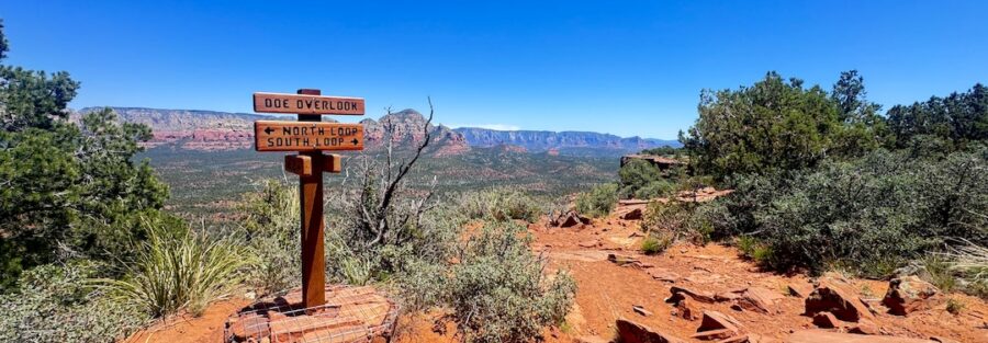
The Mesa Top
The top of Doe Mountain is a broad, flat plateau with low desert scrub and open rock surface in every direction. The loop trail traces the rim of the mesa, giving you changing angles on the full Sedona red rock panorama as you move around the edge. Bear Mountain and Doe Mountain’s twin summits frame the west. Boynton Canyon drops away to the north. The Village of Oak Creek and Bell Rock sit on the southern horizon. Cathedral Rock and Courthouse Butte to the southeast. There is no single best viewpoint. The whole rim is the viewpoint.
The Light
Sunrise and sunset on the Doe Mountain mesa are exceptional. The flat top puts you above all the immediate canyon walls and gives you an unobstructed horizon in both directions. Sunrise hits the red cliffs to the east first and works its way across the basin as the light angle drops. Sunset turns the western formations gold and then deep orange before the color dies. Plan to be on the mesa at least 30 minutes before your target light window to find your composition and get settled before the show starts.

Trail Difficulty and Length
Doe Mountain Loop runs 2.4 miles with 620 feet of elevation gain. Most of that gain happens in the first half mile on the switchbacks. The mesa top section is flat and easy. The cliff scramble near the top is brief but asks for hands and confident footing on the sandstone. Solid trail runners or light hikers are fine for most people. The loop direction matters slightly. Going counterclockwise puts the steepest section early when legs are fresh and makes the scramble a descent on the way back, which is harder on some hikers. Clockwise gives you the scramble as a climb, which most people find more intuitive.
Dog Friendly?
Doe Mountain Loop allows leashed dogs. The switchbacks and mesa top are manageable for most dogs. The cliff scramble near the summit is the one section worth assessing honestly. Smaller dogs and older dogs may find the exposed rock moves awkward. The mesa surface is rough sandstone, which is hard on paws over extended time. Bring water for your dog, no sources on the trail, and pack out all waste. The mesa rim has some significant drop-offs, keep your dog close at the edges.

What to Bring
At least a liter of water per person. More in summer. Sunscreen and a hat since the mesa top has no shade. Grippy trail shoes or hikers for the switchbacks and the cliff scramble. A camera. The 360-degree mesa view rewards wide-angle lenses and panoramas.
Best Time to Hike Doe Mountain Loop
Spring (March through April) and fall (October through November) are the prime windows. Temperatures in the 60s and 70s, good light at both ends of the day, and manageable crowds compared to summer. Summer is possible with an early start, the switchbacks are exposed and heat builds fast. Be on the mesa and heading back down before 10 a.m. in July and August. Winter works well in Sedona. Snow is rare and the cooler air makes the climb easier. Icy conditions on the cliff scramble are the one winter caution: check conditions and turn back if the rock is glazed.
Rules and Regulations
Doe Mountain is managed under Coconino National Forest and the Red Rock Pass Program. Stay on designated trails. The mesa-edge vegetation and desert crust are fragile and do not recover quickly from off-trail foot traffic. No camping on the mesa top. No campfires anywhere on the trail. No drones. No rock, plant, or artifact collection. Pack out all waste. Stay back from cliff edges, the sandstone rim can be unstable near drop-offs.

Where to Stay Near Sedona
The Enchantment Resort at the end of Boynton Pass Road is the closest full-service property to the Doe Mountain Trailhead. For points travelers, Marriott Bonvoy covers Sedona and the Verde Valley. IHG Rewards has properties in the broader region. Hilton travelers can search Sedona-area options through Hilton Honors. Uptown Sedona is the most convenient base for exploring the full red rock corridor and keeps you close to food and galleries for post-hike winding down.
Camping Nearby
Dispersed camping along Schnebly Hill Road is the closest free option in the Sedona area. The Fox Borough pull-offs on Schnebly Hill Road offer canyon views and open platforms, free on Coconino National Forest land with a 14-day limit. Nolan Tank and Edge of the World are two additional dispersed sites in the area with solid access for high-clearance vehicles. No water, no hookups, no services at any dispersed site. Bring everything.
Nearby Adventures
Boynton Canyon Trail is the big sibling just down the road, 6.5 miles with 918 feet of gain, a vortex, the Subway Cave, and ancient ruins. Worth combining with Doe Mountain into a full Sedona day. Fay Canyon Trail is the easy counterpart, 2.4 miles and 298 feet of gain with a hidden arch and canyon shade. Devil’s Bridge Trail is 3.9 miles with 521 feet of gain to the largest natural sandstone arch in the Sedona area. For non-hiking Sedona, Tlaquepaque Arts and Shopping Village is the best post-trail stop for local art and food. The Amitabha Stupa and Peace Park near Boynton Pass Road is a quiet stop worth 30 minutes if you’re already in the neighborhood. The Chapel of the Holy Cross on AZ-179 is the Sedona landmark: architecture built directly into the cliff face with sweeping red rock views and worth every minute of the short walk up.
Plan This Hike
AllTrails has Doe Mountain Loop documented with GPS tracking, current conditions, and user reviews noting the cliff scramble section and best mesa viewpoints. The offline map is useful for identifying the rim spur trails that branch off the main loop. Download before you leave. Plan your hike on AllTrails here.
Chase the Quiet
I sat on the north rim of the Doe Mountain mesa for about 20 minutes after finishing the loop. Boynton Canyon running below me, Bear Mountain catching the last of the morning light, the whole Sedona basin laid out from a perspective most hikers on the bigger trails never get. Two point four miles. Forty minutes up. That’s a good return on investment for a mesa-top view that puts you above everything else in the corridor.
Support the Adventure
To make your walls less boring, check out my photography portfolio and bring a piece of the wild and my story into your home.
If you’d like to fuel future adventures, you can donate a coffee on Ko-Fi. Every cup keeps me chasing sunrises and stories.
When you shop using my affiliate links, every click helps support this blog at no extra cost to you. It’s a small way to keep Unicorn Adventure alive and kicking while I keep exploring.
Subscribe to my mailing list for future updates, new stories, and behind-the-scenes adventures.
Stay connected with me on Instagram and Facebook for more photos and daily inspiration.
Thanks for being part of the journey, Unicorn Squadron!

Theo Maynard is a landscape photographer and adventure blogger based in Salt Lake City. He chases remote desert and mountain light across the American West, documents it all solo, and shares the journey through Unicorn Adventure. He’s on the autism spectrum, and that’s not a footnote, it’s the whole story. He creates to inspire others to get outside, chase what lights them up, and live their best possible life. Unapologetically himself.