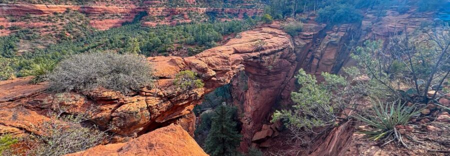
Most hikes have a destination. Devil’s Bridge has a moment. You climb 521 feet through juniper scrub and red sandstone, work up a steep rocky staircase with no handrails, and then you’re standing on a 54-foot arch over a canyon with nothing but air and Sedona’s red rock country stretching out in every direction. That moment is the whole point.
Places like this cut through everything. No noise, no crowd chatter getting past the walls in my head, just the wind off the canyon and the weight of sandstone under your boots. I pulled Estes onto Dry Creek Road early, before the shuttle crowds showed up, and had the arch to myself for about ten minutes. It was enough.
Quick Facts
|
Location |
Sedona, Arizona |
|
Coordinates |
|
|
Distance |
3.9 miles (out and back from Dry Creek Vista Trailhead) |
|
Elevation Gain |
521 ft |
|
Difficulty |
Moderate |
|
Time |
3 hours |
|
Dogs Allowed |
Yes, on leash |
|
Fee |
Red Rock Pass may be required depending on parking location ($5/day or $15/week) |
How to Get There
Devil’s Bridge sits in Coconino National Forest, a short drive from downtown Sedona. Take AZ-89A to Dry Creek Road and head north. You’ll reach the Dry Creek Vista Trailhead parking area after about two miles. From there, you hike roughly 1.3 miles along a dirt road to the Devil’s Bridge Trailhead, then continue on the main trail to the arch.
If you have a high-clearance 4WD vehicle, the dirt road to the trailhead is drivable and cuts the total round trip to about 2 miles. The road is rough with loose rock, rutted sections, and a few steep pitches. Know your rig before you commit. Estes handles it fine, but a stock sedan will not enjoy the experience. When the Sedona Shuttle is operating (Thursday through Sunday, 7 a.m. to 5:30 p.m.), the Dry Creek Vista Trailhead lot closes to private vehicles. Park at a designated park-and-ride in central Sedona and ride the shuttle free. Details at sedonashuttle.com.

Parking Information
Parking at Dry Creek Vista Trailhead is free and does not require a Red Rock Pass. The lot fills early on weekends. Arrive before 8 a.m. or plan to shuttle. If you park at the Mescal Trailhead instead, you’ll connect to Devil’s Bridge via the Chuckwagon Trail, adding distance but giving you a quieter approach. Some alternative trailheads in the area do require a Red Rock Pass ($5 day pass or $15 weekly). Check current signage when you arrive.
Cell Service and Navigation
Coverage is solid along Dry Creek Road and at the trailhead. Verizon and AT&T both work well in the Sedona area. As you climb higher on the trail, signal can drop in the rocky terrain. Download an offline map before you leave. AllTrails, Gaia GPS, and Google Maps offline all cover this route. The trail is well-marked and hard to lose, but having a downloaded map is good practice anywhere in red rock country.

What to Expect on Devil’s Bridge
The Trail
The dirt road section from Dry Creek Vista is wide, flat, and easy walking. You’ll move through open desert with Chimney Rock and Capitol Butte visible in the distance. The landscape shifts from scrubby juniper flats to a broader canyon view as you near the trailhead. From the Devil’s Bridge Trailhead, the main trail climbs steadily through red rock terrain, switchbacking upward on a mix of packed dirt and natural stone.
The Arch
The final push to the bridge is the steepest section. Natural stone steps carved into the sandstone take you up through a narrow rocky channel. No handrails, some exposure, and a few moves that require using your hands. It is not technical climbing, but it is not a leisurely stroll either. Take your time, watch the rock surface, and you will be fine. Then you step onto the bridge itself. It is 54 feet high and about 45 feet long, wide enough to walk across comfortably. The canyon drops away on both sides. Chimney Rock fills the frame to the south. The whole Sedona red rock basin opens up around you. Stand on the arch for the photos. Sit on the edge of the approach for the view. Both are worth every step of the climb.
Trail Difficulty and Length
Devil’s Bridge via Dry Creek Vista is 3.9 miles round trip with 521 feet of elevation gain. The dirt road section adds easy flat miles. The main trail climbs moderate switchbacks before the steep stone staircase to the arch. That final stretch is exposed and demands attention. Sturdy hiking shoes or boots with real grip are worth it here. Trail runners work fine if you have confident footing. The height at the top intimidates some hikers, especially on the arch itself. If heights are a problem, the viewpoint just below the bridge is still an outstanding stop.

Dog Friendly?
Dogs are allowed on Devil’s Bridge Trail on leash. The dirt road section is easy on paws. The rocky stone steps near the top are the challenge, tough on small breeds or older dogs, and the arch itself has significant exposure on both sides. Assess your dog honestly before committing to the final climb. Bring plenty of water. The trail offers minimal shade and the desert heat builds fast. Pack out all waste and keep your dog off any vegetation near the edges.
What to Bring
Bring 2 liters of water minimum per person. More in summer. Sunscreen, a hat, and sunglasses for the exposed sections. Hiking boots or grippy trail shoes for the rocky steps. A trekking pole can help on the descent if your knees protest. Bring a camera, you will want one at the arch.
Best Time to Hike Devil’s Bridge
Spring (March through April) and fall (October through November) are the ideal windows. Temperatures sit in the 60 to 80 degree range and the light on the red rock is exceptional at both ends of the day. Summer is possible but punishing, over 100 degrees by midday, so start before 7 a.m. if you go in summer. Sunrise is the best time for photography at the arch. Golden light hits the sandstone from behind you as you face west, the canyon drops into warm shadow, and you often have the arch to yourself before the crowds arrive. Sunset is a close second but the arch faces west, so the light gets harsh before the golden hour hits.
Rules and Regulations
Devil’s Bridge is in Coconino National Forest. Stay on the designated trail at all times. The desert vegetation on both sides of the trail is fragile and slow to recover. Do not venture off-trail or cut switchbacks. Do not climb on the arch itself beyond the standard crossing point, and do not approach the edges recklessly. Pack out everything you bring in. No campfires. No drones. Rock, plant, and artifact collection is prohibited. The arch is the most popular trail in Sedona, the reason these rules matter here more than almost anywhere.
Where to Stay Near Sedona
Sedona has properties from full resort luxury to smaller boutique stays. The Enchantment Resort near Boynton Canyon is the most dramatic option in the area. For points travelers, Marriott Bonvoy has properties in Sedona and the Verde Valley. IHG Rewards covers the broader region as well. Hilton travelers can browse Sedona-area options through Hilton Honors. Uptown Sedona is the most convenient base for trailhead access and keeps you close to food and galleries for post-hike recovery.
Camping Nearby
Dispersed camping along Schnebly Hill Road is the closest free option to the Devil’s Bridge area. The Fox Borough pull-offs are accessible with a high-clearance vehicle and offer open desert platforms with canyon views. Nolan Tank and Edge of the World are two additional dispersed sites in the broader Sedona area, free on BLM and Coconino National Forest land with a 14-day limit. No water, no hookups, no services. Bring everything you need, including a way to pack out all waste.
Nearby Adventures
The Boynton Canyon Trail is the best full-day hike near Devil’s Bridge, 6.5 miles with 918 feet of gain, a famous vortex, the Subway Cave, and ancient ruins at the canyon end. Fay Canyon Trail is a shorter family-friendly option at 2.4 miles and 298 feet of gain with a hidden arch tucked into the canyon wall. The Munds Wagon, Cow Pies and Hangover Loop stretches 8.2 miles with 1,181 feet of gain for hikers who want a real workout with summit views. Beyond hiking, the Chapel of the Holy Cross is a landmark worth the short detour, an architectural wonder built into the cliff face with sweeping valley views. Tlaquepaque Arts and Shopping Village in Sedona is the best stop for local art, food, and wandering after a trail day. The Oak Creek Canyon drive on AZ-89A north of Sedona is one of the finest canyon drives in Arizona.
Plan This Hike
AllTrails has Devil’s Bridge thoroughly documented, including GPS tracking, current trail conditions, and user reviews that flag shuttle schedules and lot closures in real time. Download the offline map before you leave. The route from Dry Creek Vista through to the arch is covered in detail, including the rocky final push and the arch crossing. Plan your hike on AllTrails here.
Chase the Quiet
Ten minutes alone on that arch before the first shuttle crowd showed up. The canyon below was still in shadow, the rock warm under my hands from the overnight air finally burning off. Standing on a 54-foot natural bridge in the middle of the desert at sunrise, it does something to your sense of scale that photographs only half-capture. You are small. The canyon is enormous. The morning is yours. That’s the version of Devil’s Bridge worth chasing.
Support the Adventure
To make your walls less boring, check out my photography portfolio and bring a piece of the wild and my story into your home.
If you’d like to fuel future adventures, you can donate a coffee on Ko-Fi. Every cup keeps me chasing sunrises and stories.
When you shop using my affiliate links, every click helps support this blog at no extra cost to you. It’s a small way to keep Unicorn Adventure alive and kicking while I keep exploring.
Subscribe to my mailing list for future updates, new stories, and behind-the-scenes adventures.
Stay connected with me on Instagram and Facebook for more photos and daily inspiration.
Thanks for being part of the journey, Unicorn Squadron!

Theo Maynard is a landscape photographer and adventure blogger based in Salt Lake City. He chases remote desert and mountain light across the American West, documents it all solo, and shares the journey through Unicorn Adventure. He’s on the autism spectrum, and that’s not a footnote, it’s the whole story. He creates to inspire others to get outside, chase what lights them up, and live their best possible life. Unapologetically himself.