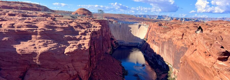
Glen Canyon Dam is one of the most significant pieces of water infrastructure in the American West, holding back 27 million acre-feet of Colorado River water in Lake Powell behind a 710-foot concrete arch. The Dam Overlook Trail puts you directly above the dam on a 0.5-mile walk from a pullout on Scenic View Drive with views of the dam face, the Colorado River as it exits the dam, the Glen Canyon Bridge, and the desert canyon country spreading in every direction. It’s a 30-minute stop that reframes the scale of the dam in a way the visitor center and the highway bridge don’t fully deliver.
Quick Facts
|
Trail Name |
Dam Overlook Trail |
|
Location |
Glen Canyon National Recreation Area, near Page, Arizona |
|
Coordinates |
|
|
Distance |
~0.5 miles roundtrip |
|
Elevation Gain |
Less than 50 feet |
|
Difficulty |
Easy |
|
Time |
20-45 minutes |
|
Dogs Allowed |
Yes, on leash |
|
Fee |
No fee for Dam Overlook Trail; Glen Canyon NRA entry fee ($35/vehicle) may apply depending on access point |
|
AllTrails |
How to Get There
From Page, Arizona, head west on US-89 toward the Glen Canyon Dam. Before crossing the bridge over the Colorado River, turn right onto Scenic View Drive. The trailhead parking area is on the right side of Scenic View Drive with clear signage. The drive from downtown Page is about 5 minutes.
From Salt Lake City, Page is approximately 4.5-5 hours south on I-15 and US-89 through Kanab. From Las Vegas, about 4 hours northeast via I-15 and US-89. From Flagstaff, about 2 hours north on US-89. Page sits at the junction of US-89 and AZ-98, making it accessible from multiple directions in the Colorado Plateau.
Parking Information
Small free parking lot directly at the Scenic View Drive trailhead. Space is limited and fills quickly during peak tourist season in spring and fall. Morning arrivals and late afternoon visits are the less crowded windows. The location is a few minutes from the Glen Canyon Dam Visitor Center, which has larger parking if overflow is needed for the dam visit itself.
Cell Service and Navigation
Cell coverage is solid in the Page area and at the dam overlook given the proximity to town. Download AllTrails offline as standard practice. The Dam Overlook Trail is short and direct with no navigation complexity.
What to Expect at the Dam Overlook
The View
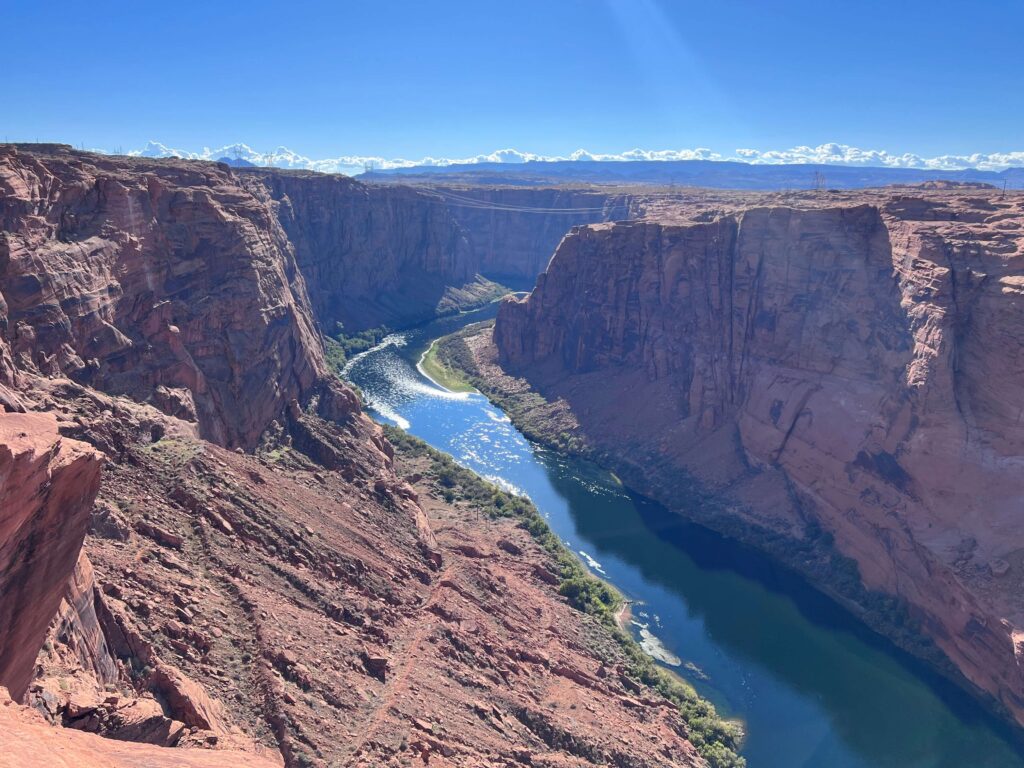
The overlook puts you directly above Glen Canyon Dam, one of the largest concrete arch dams in the United States. From this position, the full scale of the structure is readable in a way it isn’t from the visitor center or the bridge downstream. The dam face drops to the Colorado River 710 feet below; the river below the dam is a fraction of its pre-dam volume, the deep blue-green of controlled release rather than the muddy red of seasonal flood. Lake Powell stretches north and east through the canyon.
The Glen Canyon Bridge is visible from the overlook, the original highway bridge that now serves pedestrian access to the dam area. The canyon walls on both sides of the dam are Navajo Sandstone and Entrada Sandstone, the same rock formations that characterize this part of the Colorado Plateau.
For photography: the overlook faces roughly southwest, making late afternoon the natural light window when the dam face and canyon walls are illuminated directly. Morning is backlit from this position. The dam in late afternoon light, with the blue-green of the river below and the red canyon walls framing it, is the version of the shot worth waiting for. Wide-angle for the full dam and canyon context, mid-range for the dam face and release structures.
The Context
Glen Canyon Dam is a complex subject for anyone who spends time in the Colorado Plateau. It created Lake Powell and drowned one of the most spectacular canyon systems in North America. The dam generates power for the Southwest and stores water for the Colorado River Compact states. The tradeoffs are still being debated in 2026 as Lake Powell’s water level fluctuates with drought cycles and water management decisions.
From the Dam Overlook, you’re looking at the infrastructure of that entire story. The visitor center provides the full historical and operational context if you want it. The overlook gives you the visual scale.
Trail Difficulty and Length
Easy by any measure. The 0.5-mile roundtrip on maintained path with minimal elevation change is accessible to virtually everyone who can walk a city block. The rocky sections near the overlook edge require some footing care but nothing demanding. Budget 20-45 minutes depending on how long you spend at the overlook.
Dog Friendly?
Yes. Dogs are welcome on leash. The short paved and maintained path is comfortable for dogs. Keep dogs leashed and away from overlook edges where drops are significant. The desert heat in Page in summer can make even short walks hard on dogs; bring water and watch paw temperatures on the surface.
What to Bring
Water for a desert stop even on a short walk. The Page, Arizona summer temperature regularly exceeds 100°F and the exposed overlook amplifies that. Sun protection mandatory in summer. Comfortable shoes; no special footwear required. A camera with wide-angle capability for the overlook panorama.
Best Time to Visit
Spring (March through May) and fall (September through November) are the comfortable temperature windows. Summer is the peak tourist season in Page but also the most difficult heat to contend with. Early morning and late afternoon visits in summer are manageable. The late afternoon light window for photography is worth the wait regardless of season.
Winter is possible with fewer crowds and cooler temperatures. The Colorado Plateau can see cold mornings and occasional snow, though the dam area typically remains accessible.
Rules and Regulations
Glen Canyon National Recreation Area rules apply. Stay on the designated trail and away from the overlook edge. Leave No Trace principles throughout. Dogs on leash. The overlook is near active NPS and Bureau of Reclamation operations; follow all posted signage regarding security and access zones near the dam itself.
The Glen Canyon NRA vehicle entry fee is $35; depending on your approach to the Dam Overlook Trail, this fee may apply. Check current access and fee requirements at nps.gov/glca before your visit. The America the Beautiful Annual Pass covers NRA entry fees.
Where to Stay in Page
Page has developed lodging with chain hotels at US-89 and Lake Powell Boulevard. For points travelers, check available Marriott Bonvoy properties in Page, IHG Rewards hotels in Page, and Hilton Honors options in Page. Page is a small town; book early for spring and fall visits when the Page area is at its busiest.
Camping Nearby
Wahweap Campground near the Lake Powell marina is the developed option for the Page area. Glen Canyon NRA has dispersed camping on BLM land throughout the recreation area. Lees Ferry Campground is about 30 miles south of Page on US-89A and serves as a base for the Lees Ferry hiking area.
Nearby Adventures
Other concentrated Page area trails: Horseshoe Bend Trail, Hanging Garden Trail (1.2 miles / 62 ft gain), Colorado River via Lees Ferry (2.5 miles / 101 ft gain), Beehive Trail / The New Wave, and Glen Canyon Bridge. The Dam Overlook serves as one component of a full Page, Arizona day that hits multiple stops from the same US-89 corridor.
Horseshoe Bend Trail is the most famous stop in the Page area: the Colorado River bending 270 degrees around a massive Navajo Sandstone formation, visible from a 1.5-mile roundtrip paved trail. It’s one of the most photographed natural features in the American Southwest and worth treating as a separate post and stop.
Antelope Canyon, a few miles east of Page, is the other major Page area destination. The upper and lower canyons are commercial operations requiring guided tours and permits. Not a hike in the trail sense, but the most photogenic slot canyon in the world by visitor count.
The Glen Canyon Dam Visitor Center is adjacent to the bridge approach and provides the full engineering, historical, and water management context for what you see from the Dam Overlook Trail. Guided tours of the dam interior are available; worth doing if the story behind the structure interests you.
Plan This Hike
AllTrails has the Dam Overlook Trail mapped with offline capability. Plan your visit on AllTrails and download before leaving Page in case signal is unreliable near the dam operations area.
Chase the Quiet
The Glen Canyon Dam holds back more water than almost any structure in the American West. From the overlook, the dam and the river below it are small-looking against the canyon. That’s the trick the Colorado Plateau plays on everything you put in it: it scales everything human down to the size of the landscape around it. That’s part of why this region pulls people back. The dam is enormous by any engineering measure. From the overlook, it looks about right for the canyon it sits in. Which tells you something about the canyon.
Support the Adventure
To make your walls less boring, check out my photography portfolio and bring a piece of the wild and my story into your home.
If you’d like to fuel future adventures, you can donate a coffee on Ko-Fi. Every cup keeps me chasing sunrises and stories.
When you shop using my affiliate links, every click helps support this blog at no extra cost to you. It’s a small way to keep Unicorn Adventure alive and kicking while I keep exploring.
Subscribe to my mailing list for future updates, new stories, and behind-the-scenes adventures.
Stay connected with me on Instagram and Facebook for more photos and daily inspiration.
Thanks for being part of the journey, Unicorn Squadron!

Theo Maynard is a landscape photographer and adventure blogger based in Salt Lake City. He chases remote desert and mountain light across the American West, documents it all solo, and shares the journey through Unicorn Adventure. He’s on the autism spectrum, and that’s not a footnote, it’s the whole story. He creates to inspire others to get outside, chase what lights them up, and live their best possible life. Unapologetically himself.