There’s no trail. There’s no shade. There’s a giant alien rock bowl baked into the middle of the desert, and you’re going to hike 7.6 miles across open slickrock to reach it.
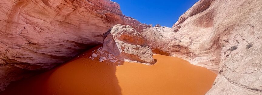
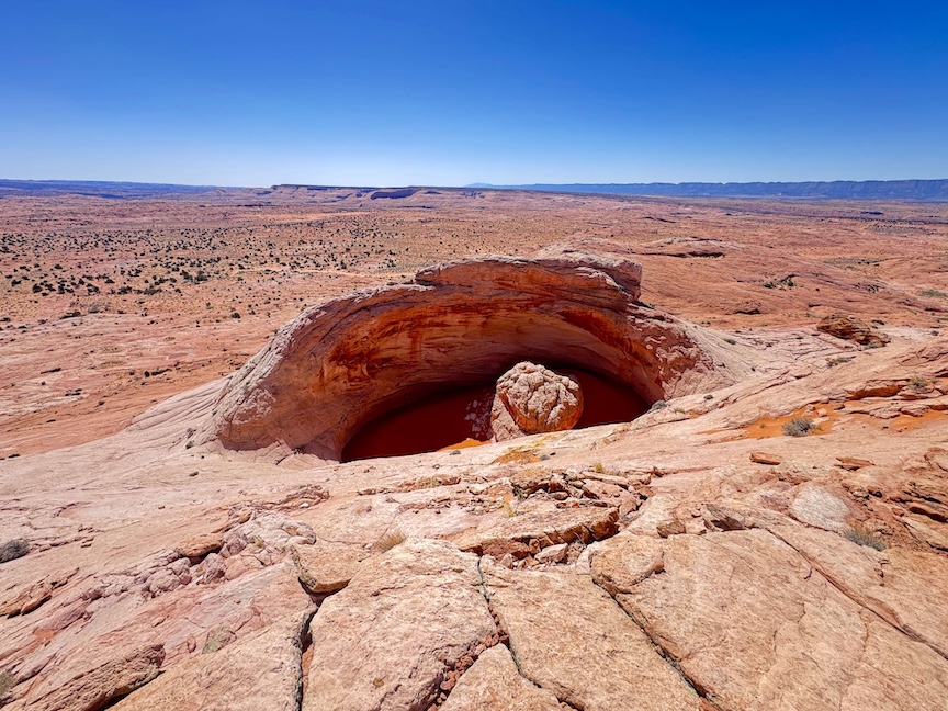
The Cosmic Ashtray, also called the Volcano, sits in the backcountry east of Escalante on BLM land inside Grand Staircase-Escalante National Monument. It’s a massive circular depression in the slickrock with a strange rock formation rising from the center. Nobody mistakes it for anything ordinary. The approach rolls across an ocean of bare sandstone with no real trail to follow, just cairns, GPS, and your own judgment. I drove Estes out on Spencer Flat Road and spent a full day out here. The solitude was absolute. The landscape was genuinely alien. And for a brain that spends most of its time pattern-matching in overdrive, navigating trackless slickrock is one of the most clarifying things I do.
Quick Facts
| Trail Name | Cosmic Ashtray via Volcano Trail |
| Location | Grand Staircase-Escalante NM, near Escalante, Utah |
| Coordinates | 37.7104° N, 111.3575° W |
| Distance | 7.6 miles (round trip) |
| Elevation Gain | 810 feet |
| Difficulty | Moderate |
| Time | 4-6 hours |
| Dogs Allowed | Yes (with precautions) |
| Fee | None |
How to Get There
From Escalante, head east on Highway 12. Turn onto Spencer Flat Road and drive approximately 6 miles to the Volcano Trail trailhead. The road is graded dirt and navigable in dry conditions, but high clearance is strongly recommended. After any rain, the surface turns to slick clay. Don’t push it in a sedan. Download your navigation before you leave because signal disappears well before the trailhead. The GPS coordinates (37.7104, -111.3575) will get you to the parking area.
Parking Information
Parking is a wide pull-off along the dirt road. No designated lot, no facilities, no fee. Pull completely off the road surface and make sure you’re not blocking anything. Lock your vehicle and stash valuables out of sight. This is a remote area with no services nearby. Double-check conditions before heading out: a muddy desert road back to the highway turns a great day into a long one.
Cell Service and Navigation
Zero cell service at the trailhead and on trail. This is not a connected landscape. Download AllTrails or Gaia GPS maps offline before you leave Escalante. A dedicated GPS unit is a smart backup. The Cosmic Ashtray route is not marked by a formal trail, and navigation relies on cairns, landmarks, and your map. Getting turned around on open slickrock is easier than it sounds, especially on the return when fatigue sets in and landmarks start looking the same.

What to Expect on the Cosmic Ashtray via Volcano Trail
The Approach
The hike starts at the Spencer Flat Road pull-off and immediately puts you on open slickrock. There’s no packed dirt trail and no tree cover. You’re navigating by cairns and landmarks across rolling sandstone that stretches in every direction. The terrain is gorgeous but relentless. Small desert shrubs push up from cracks in the rock. Jackrabbits scatter from the brush. The scale of the landscape only registers when you look back at where you started and realize how far you’ve come.
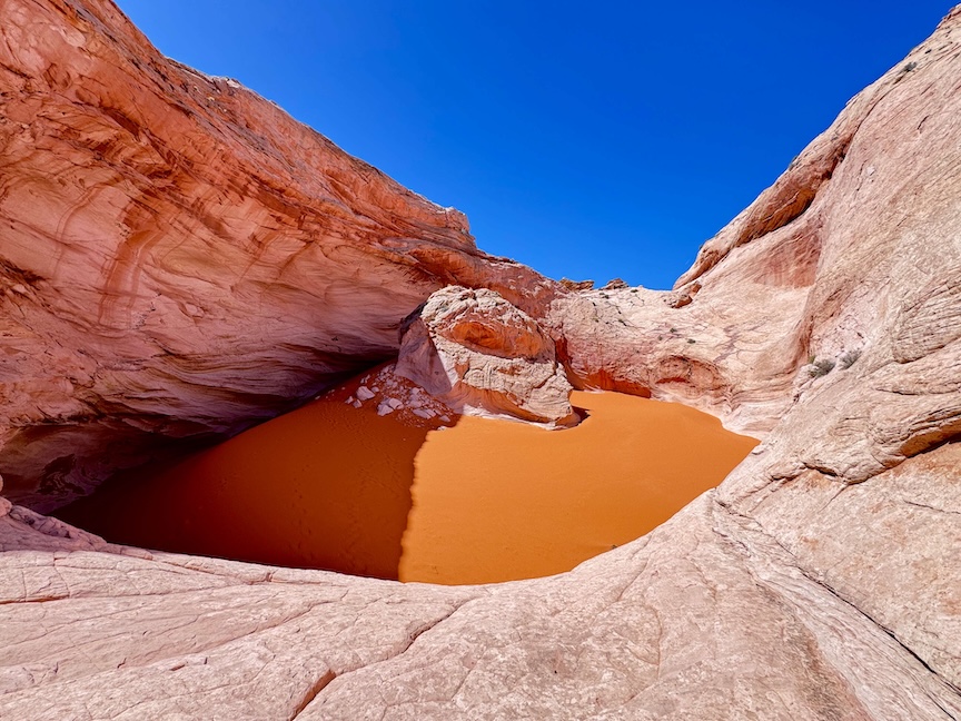
The formation announces itself when you crest the right ridgeline. A perfectly circular depression carved into the sandstone, wide and deep, with a dramatic rock formation rising from the center that gives the place its name. The walls of the crater are banded orange and red. Standing on the rim, looking down into it, the alien comparisons aren’t a stretch. Nothing else in the landscape looks like this. Walk the rim. Scramble down into it if conditions allow. Plan to spend some time here because you hiked a long way to get there.
Trail Difficulty and Length
The Cosmic Ashtray via Volcano Trail is 7.6 miles round trip with 810 feet of elevation gain. It’s rated moderate, but that underestimates the navigation demand. The entire route crosses uneven slickrock with no formal trail. You’re scrambling, route-finding, and managing exposure the entire time. The desert sun on open sandstone is brutal. Budget 4 to 6 hours and plan your water accordingly. This is not a casual afternoon hike. Confident navigation skills and solid desert experience are a real advantage out here.
Dog Friendly?
Yes, but this one requires extra preparation. The slickrock heats up fast and there’s no natural water along the route. Bring more water than you think your dog needs, check their paws regularly on the hot rock, and start early to beat peak heat. Late spring through early fall, a midday start is a bad idea for dogs. Early morning or late afternoon is the move.
What to Bring
Water is the priority. At least 3 liters per person on a moderate-weather day, more in summer. The route is fully exposed with no shade and the slickrock radiates heat. Sun protection is essential: hat, sunscreen, and sunglasses. Sturdy trail runners or hiking shoes with good grip handle slickrock better than smooth-soled shoes. Trekking poles help on the uneven terrain. A GPS device or phone loaded with offline maps is non-negotiable. Bring a headlamp in case you’re out longer than expected. Snacks to eat at the Ashtray, because you’ll want to sit with it a while.

Best Time to Hike the Cosmic Ashtray
Spring (March through May) and fall (late September through November) are the best windows. Temperatures are manageable and the desert light on the sandstone is exceptional. Summer is technically doable but the heat on open slickrock is serious and there’s nowhere to escape it. Start by 6 a.m. if you’re going in summer. Winter is less brutal than summer but freezing nights and ice on the slickrock add complications.
For photography, late afternoon light is the move. The low sun hits the crater walls and lights up the orange sandstone from the side, which brings out the texture and banding in the rock. The alien head formation photographs well with a wide lens that captures it in context of the crater. Golden hour here is worth the extra miles.
Rules and Regulations
The Cosmic Ashtray sits on BLM land within Grand Staircase-Escalante National Monument. No permits are required and there’s no day-use fee. Leave No Trace applies fully: pack out everything, don’t disturb the rock surface, and don’t add or move cairns. The route depends on existing cairns for navigation, so messing with them creates real problems for other hikers. Check current conditions with the Escalante Interagency Visitor Center before heading out, particularly around road conditions on Spencer Flat Road.
Where to Stay Near Escalante
Escalante has solid lodging in town. Entrada Escalante Lodge and Canyon Country Lodge are reliable bases for Grand Staircase trips.
Camping Nearby
Dispersed camping on BLM land is the natural fit for a Cosmic Ashtray trip. Spencer Flat itself has dispersed options, and Cedar Point, South Turkey, and Spencer Flat campground are all worth knowing about for the Grand Staircase area. No hookups, no reservations, minimal facilities. The sky out here on a clear night is exceptional.
The Calf Creek Recreation Area campground on Highway 12 is a reservable option with restrooms, right at the Lower Calf Creek Falls trailhead. It fills fast on weekends. Book through recreation.gov.
Nearby Adventures
The Grand Staircase area stacks well. Lower Calf Creek Falls is 6.1 miles with 531 feet of gain and ends at a 126-foot waterfall, a completely different experience from the Ashtray. Zebra and Tunnel Slot Canyons cover 6.6 miles through some of the most visually striking slot canyon terrain in the monument. Escalante Natural Bridge is a shorter 4.4-mile out-and-back worth adding to any multi-day itinerary.
For drives, the Burr Trail and Hells Backbone OHV Trail are both in the area and deliver big scenery with less leg effort. Moki Dugway is a short drive south and one of the most dramatic roads in Utah.
Off the trail, the Escalante Petrified Forest State Park is an easy stop with fossilized wood and colorful badlands. The Anasazi State Park Museum in Boulder covers Ancestral Puebloan history with actual artifacts and a reconstructed village on site.

Plan This Hike
AllTrails has the Cosmic Ashtray via Volcano Trail with a downloadable map, user reviews, and recent conditions. Given the navigational demands of this route, downloading the offline map before you lose signal is essential. Other hikers’ notes about cairn placement and current conditions are genuinely useful here.
AllTrails Pro is worth it for remote desert routes like this where offline navigation is the difference between a great day and a long one.
Chase the Quiet
Standing on the rim of the Cosmic Ashtray with nothing around you but slickrock and silence, you realize how much noise the normal world runs at. No trail markers, no crowd noise, no signal. Just the wind and the sandstone and a rock bowl that looks like it was dropped here from another planet. I did not expect to feel small in a good way out here. I did.
Support the Adventure
To make your walls less boring, check out my photography portfolio and bring a piece of the wild and my story into your home.
If you’d like to fuel future adventures, you can donate a coffee on Ko-Fi. Every cup keeps me chasing sunrises and stories.
When you shop using my affiliate links, every click helps support this blog at no extra cost to you. It’s a small way to keep Unicorn Adventure alive and kicking while I keep exploring.
Subscribe to my mailing list for future updates, new stories, and behind-the-scenes adventures.
Stay connected with me on Instagram and Facebook for more photos and daily inspiration.
Thanks for being part of the journey, Unicorn Squadron!

Theo Maynard is a landscape photographer and adventure blogger based in Salt Lake City. He chases remote desert and mountain light across the American West, documents it all solo, and shares the journey through Unicorn Adventure. He’s on the autism spectrum, and that’s not a footnote, it’s the whole story. He creates to inspire others to get outside, chase what lights them up, and live their best possible life. Unapologetically himself.