

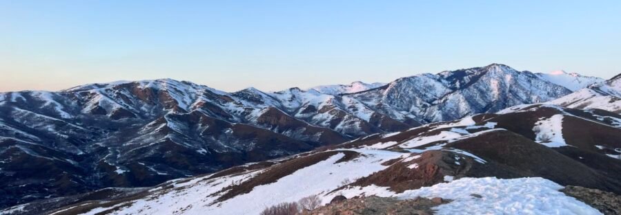
Two summits for one hike. The views are different from each one and both are worth reaching. Avenue Twin Peaks sits in the Uinta-Wasatch-Cache National Forest above the Avenues neighborhood in Salt Lake City. The trail climbs 1,600 feet over 4 miles round trip through canyon terrain and onto a ridgeline that delivers 360-degree views of the Salt Lake Valley, the Great Salt Lake, and the full arc of the Wasatch Range. It’s a harder hike than the mileage makes it sound and sees less traffic than the more well-known Wasatch trails, which is its main advantage. Here’s what you need to hike Avenue Twin Peaks.
Quick Facts
| Trail Name | Avenue Twin Peaks |
| Location | Uinta-Wasatch-Cache National Forest, Salt Lake City, Utah |
| Coordinates | 40.7915, -111.8630 |
| Distance | 4.0 miles (round trip) |
| Elevation Gain | 1,600 feet |
| Difficulty | Moderate to Strenuous |
| Time | 3-4 hours |
| Dogs Allowed | Yes (on leash) |
| Fee | None |
| View on Alltrails | |
How to Get There
From downtown Salt Lake City, head east on 11th Avenue through the Avenues neighborhood. The road transitions to Bonneville Boulevard as it curves north. Follow Bonneville Boulevard to the trailhead parking area near the City Creek Canyon entrance. The drive from downtown takes 10 to 15 minutes. Load the coordinates (40.7915, -111.8630) before leaving since the Avenues street grid can be disorienting if you’re not familiar with it.
Parking Information
A small lot sits near the City Creek Canyon entrance. On busy spring and fall weekends it fills before 8 a.m. Overflow runs along Bonneville Boulevard, but watch posted restrictions. No restrooms at the trailhead. Handle that before leaving downtown or the Avenues neighborhood commercial blocks. 
Cell Service and Navigation
Cell service is generally reliable at the trailhead and on the lower trail sections. It weakens on the upper ridgeline exposure depending on your carrier. Download your map offline through AllTrails as a backup. The trail is well-defined through the canyon section and the ridgeline is the obvious navigation reference above tree line. Weather builds fast on exposed Wasatch ridgelines. Afternoon thunderstorm risk is real in summer. Check the forecast and start early enough to be off the exposed ridge before midday if storms are possible.
What to Expect on Avenue Twin Peaks
The Canyon Ascent
The trail starts near the City Creek Canyon entrance and climbs steadily into the canyon through scrub oak, maple, and mixed conifers. The lower section is shaded and well-graded with a consistent ascent. In spring the understory is vivid green with wildflowers. In fall the maples go orange and red in a way that makes the lower trail worth the hike by itself. The canyon provides some shelter from wind and sun before the terrain opens up.
The Ridgeline and Summits
Above the canyon the trail reaches the ridgeline and the exposure increases immediately. The two summits of Avenue Twin Peaks appear ahead and the views open in every direction. The Salt Lake Valley spreads west, downtown Salt Lake City is visible directly below, the Great Salt Lake shimmers to the northwest, and the Oquirrh Mountains define the western horizon. Both summits are worth reaching. The view shifts enough between them to justify the extra steps. The ridgeline is narrow in places and the drop-offs are real. Stay on the trail and keep dogs close on the exposed sections. 
Trail Difficulty and Length
Avenue Twin Peaks is 4.0 miles round trip with 1,600 feet of elevation gain. The moderate-to-strenuous rating is accurate. The 1,600 feet of gain aligns with the actual steepness of the ridgeline approach. Budget 3 to 4 hours. The ridgeline is exposed and the descent on tired legs requires full attention. Don’t rush the return.
Dog Friendly?
Yes. Dogs are allowed on leash. The ridgeline has narrow sections and genuine drop-offs that require keeping dogs close and under control. Bring more water than you think they need. No water sources on trail and the exposed upper sections heat up significantly. In summer an early start is mandatory for both of you. 
What to Bring
At least 2 liters of water per person. The climb drains you and the exposed ridgeline accelerates it in summer. Sunscreen and a hat for the open upper sections. Trail shoes or hiking boots with good grip for the rocky ridgeline terrain. A wind layer for the summits since exposed Wasatch ridgelines push cold air even on warm valley days. Trekking poles help significantly on the ridgeline descent. A wide-angle lens for the summit panoramas, which are among the better city-view shots on the Wasatch Front.
Best Time to Hike Avenue Twin Peaks
Fall is the strongest season for this trail. Late September and October turn the maple and oak understory into a color show that the canyon channels beautifully. The air is clear, the valley views are sharp, and the ridgeline temperatures are manageable. Spring is the second window, with wildflowers on the lower trail and snowmelt keeping the canyon green. Summer requires an early start before the ridgeline exposure heats up and afternoon storm risk builds. Winter brings snow to the upper trail and ice to the ridgeline, which makes the exposed sections hazardous without microspikes. For photography, early morning gives you the sharpest valley views before haze builds over the Salt Lake Valley floor. The canyon section photographs well in fall with the maple color at peak. From the summits, the northwest-facing view toward the Great Salt Lake catches the best light in late afternoon. A wide-angle lens handles the full panorama from both peaks.
Rules and Regulations
Avenue Twin Peaks is in the Uinta-Wasatch-Cache National Forest. No permit, no fee. Leave No Trace applies fully. Stay on the established trail to prevent erosion on the steep canyon and ridgeline sections. Dogs on leash at all times. The ridgeline drop-offs are a safety reason, not just a rule. Check the Wasatch-Cache National Forest site for any current closures or fire restrictions before heading out.
Where to Stay Near Salt Lake City
Salt Lake City has full lodging coverage within 10 to 20 minutes of the Avenue Twin Peaks trailhead. For hotel points check Marriott Bonvoy, IHG Rewards, and Hilton Honors. The Avenues neighborhood has boutique lodging within walking distance of the trailhead for hikers who want to skip the morning drive.
Camping Nearby
No camping in the immediate foothills area. Big and Little Cottonwood Canyons, 20 to 30 minutes south, have established campgrounds through Recreation.gov. Redman Campground in Big Cottonwood and the Albion Basin area in Little Cottonwood are the closest options. Both fill fast in summer. Dispersed camping on Wasatch-Cache National Forest land is available further into the Uinta foothills to the east.
Nearby Adventures
The Foothills Natural Area and adjacent canyon system have solid options above and around Avenue Twin Peaks. The Living Room Trail is the most popular foothill route in Salt Lake City with excellent city views and a distinctive rock formation at the top. Jack’s Mountain in the same Foothills Natural Area is a shorter, harder climb at 2.5 miles and 1,300 feet of gain. The Bonneville Shoreline Trail runs north and south along the ancient Lake Bonneville shoreline with multiple access points and extended mileage options. City Creek Canyon, accessible from the same trailhead area, provides a shaded creek-side hike with wildlife viewing. Mount Wire offers a different foothills ridge line with additional summit views. For the step-up day in the main Wasatch canyon system, Mount Olympus delivers 6.9 miles and 4,000 feet to one of the best summit views along the front. For a complete change of landscape, the Escalante area a few hours south is worth a dedicated trip. Lower Calf Creek Falls (6.1 mi / 531 ft), Escalante Natural Bridge (4.4 mi / 291 ft), and Zebra and Tunnel Slot Canyons (6.6 mi / 469 ft) are all canyon hiking in a completely different category from Wasatch terrain. Off the trail, Red Butte Garden and Arboretum above the University of Utah is a solid rest-day stop with maintained gardens and walking paths and excellent views of the valley. The Natural History Museum of Utah is one of the best natural history institutions in the West. The 9th and 9th neighborhood has independent restaurants and coffee shops worth hitting after a hard morning on the ridgeline.
Plan This Hike
AllTrails has Avenue Twin Peaks with a downloadable map, recent user conditions, and notes on ridgeline exposure and current trail state from other hikers. Checking recent reports is particularly useful for spring when snow lingers on the upper ridgeline sections longer than the canyon base suggests. View on Alltrails AllTrails Pro is worth it for offline maps and elevation tracking on a trail with this much gain. Knowing your elevation profile in real time helps with pacing on a 1,600-foot climb.
Chase the Quiet
Two peaks. One ridgeline. The whole Salt Lake Valley below you and the Wasatch at your back. Avenue Twin Peaks earns the views it delivers and delivers them to fewer people than the more famous trails nearby. The fall color in the canyon on the way up and the sharp air on the exposed summit are two different kinds of reward stacked in the same hike. That’s a good day. That’s what I chase. That’s what Unicorn Adventure is about. Getting out there solo, finding the places that still feel wild, and bringing back stories that remind you the world is bigger than your screen. To make your walls less boring, check out my photography portfolio and bring a piece of the wild into your home. If you’d like to fuel future adventures, you can donate a coffee on Ko-Fi. Every cup keeps me chasing sunrises and stories. When you shop using my affiliate links, every click helps support this blog at no extra cost to you. It’s a small way to keep Unicorn Adventure alive and kicking while I keep exploring. Subscribe to my mailing list for future updates, new stories, and behind-the-scenes adventures. Stay connected with me on Instagram and Facebook for more photos and daily inspiration. Thanks for being part of the journey, Unicorn Squadron.

Theo Maynard is a landscape photographer and adventure blogger based in Salt Lake City. He chases remote desert and mountain light across the American West, documents it all solo, and shares the journey through Unicorn Adventure. He’s on the autism spectrum, and that’s not a footnote, it’s the whole story. He creates to inspire others to get outside, chase what lights them up, and live their best possible life. Unapologetically himself.