Ice Box Canyon Trail is the shaded alternative in Red Rock Canyon’s trail catalog. While most Red Rock hiking is fully exposed Aztec Sandstone under the Mojave sun, Ice Box Canyon drops into a narrow gorge where the canyon walls block direct sunlight for much of the day, the temperature is noticeably cooler, and in late winter and spring a seasonal waterfall forms at the canyon’s headwall.
Quick Facts
|
Trail Name |
Ice Box Canyon Trail |
|
Location |
Red Rock Canyon National Conservation Area, near Las Vegas, Nevada |
|
Coordinates |
36.1502° N, 115.4838° W (Ice Box Canyon Trailhead on Scenic Loop) |
|
Distance |
2.1 miles roundtrip |
|
Elevation Gain |
439 feet |
|
Difficulty |
Moderate (significant boulder scrambling in the canyon interior) |
|
Time |
1.5-3 hours depending on scrambling pace |
|
Dogs Allowed |
Yes, on leash; boulder terrain is tough for most dogs |
|
Fee |
$15 per vehicle; America the Beautiful Pass accepted. Timed entry reservation required, book at recreation.gov before your visit. |
|
AllTrails |
How to Get There
From the Las Vegas Strip, take West Charleston Boulevard (NV-159) west approximately 17 miles to the Red Rock Canyon entrance. The Ice Box Canyon Trailhead is about 7 miles into the Scenic Loop Drive. The drive from Las Vegas takes about 30-40 minutes to the visitor center, then additional time on the loop road to the trailhead.
Red Rock Canyon’s timed entry reservation system requires booking at recreation.gov before arriving. Walk-up entry is not guaranteed on busy days, particularly weekends and the October through April peak season.
Parking Information
Designated trailhead parking lot on the Scenic Loop Drive, about 7 miles from the entrance. Less crowded than the Calico Tanks / Sandstone Quarry lot given the slightly more demanding trail character. Still worth arriving before 8 a.m. on peak season weekends. The $15 Scenic Loop access is part of the park entry fee.

Cell Service and Navigation
Cell coverage is solid near Las Vegas and decreases into the scenic loop. Download AllTrails offline before arriving. The trail begins on a marked wash path and transitions to open boulder scrambling inside the canyon; having the GPS track active is useful for the canyon interior where no formal trail exists. Route-finding through the boulders is the navigation challenge.
What to Expect on the Ice Box Canyon Trail
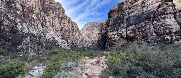
The Open Wash Approach
The trail starts in an open desert wash with the Red Rock Canyon characteristic Aztec Sandstone formations visible on the canyon walls above. The wash approach is flat and straightforward; this section gives no indication of what the canyon interior involves. The temperature on the approach is desert-standard; the cooling happens once the canyon walls close in.
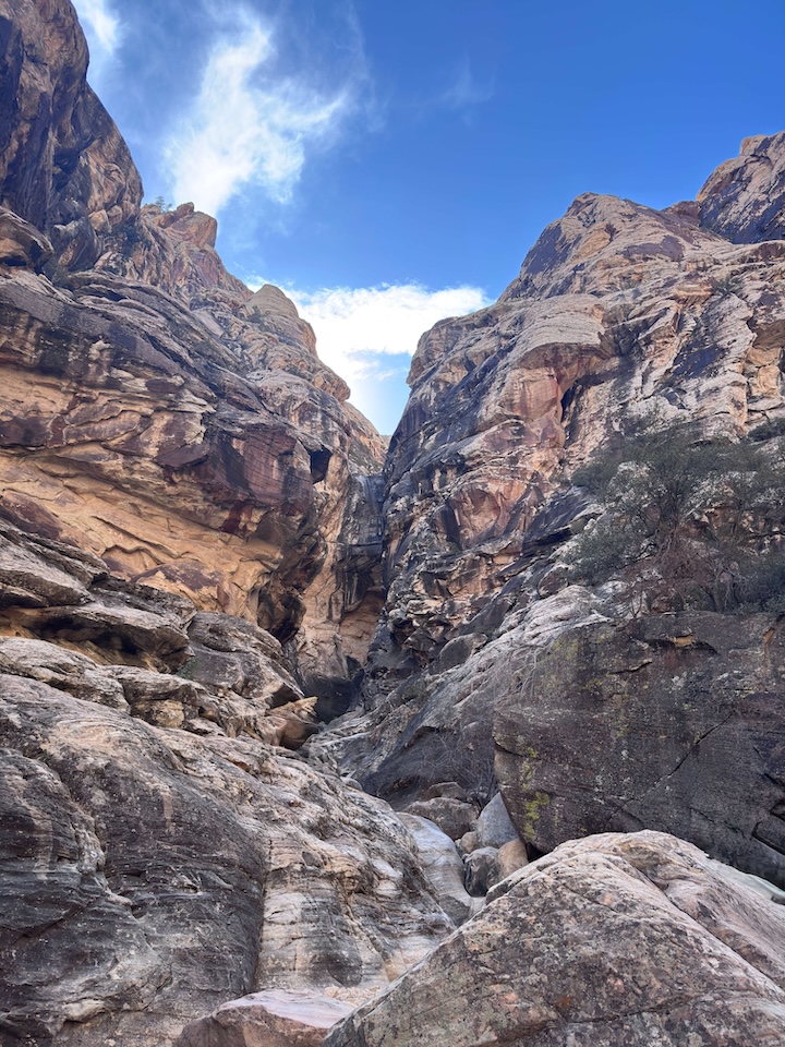
The Canyon Interior and Boulder Field
The trail enters the canyon and the character changes immediately. The walls narrow, the direct sunlight disappears, and the temperature drops, often significantly, which is why the trail carries the name it does. The Mojave Desert’s heat, which defines every exposed Red Rock Canyon trail, is absent here. In winter and spring, the canyon floor can feel cold in the shade.
The boulder scrambling is the defining physical element. The canyon floor is a field of large boulders deposited by flash floods, and navigating to the canyon headwall requires climbing over, around, and between them without a marked trail. This is not technical climbing but it’s physical work that requires balance, body position management, and comfort with using both hands. The scrambling is sustained through the canyon interior.
There is no single correct route through the boulder field. The canyon walls constrain the general direction; within that, each group finds their own path. Route-finding through the boulders is part of the experience and part of the challenge.
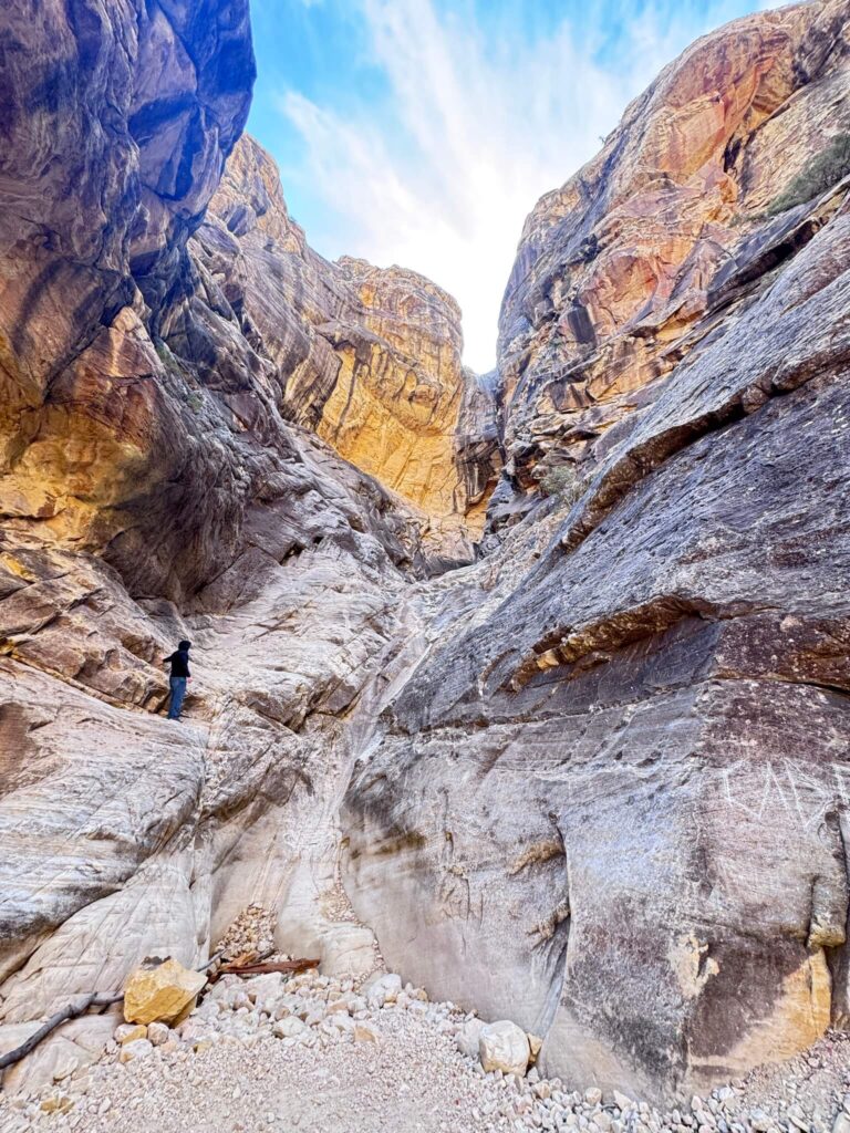
The Headwall and Seasonal Waterfall
The canyon culminates at a rock amphitheater headwall with towering walls on three sides. In late winter and spring after sufficient rainfall or snowmelt from the Spring Mountains above, a waterfall forms here. The waterfall is seasonal and not guaranteed; check AllTrails condition reports for current waterfall status before visiting if the waterfall is your primary goal. In dry conditions the headwall is still impressive, the scale of the enclosed rock amphitheater is the reward regardless of water presence.
For photography: the canyon interior in filtered and reflected light rather than direct sun, the walls diffuse the light into a quality that is different from any open desert hike. The boulder field composition with the canyon walls rising overhead. The headwall in morning light that filters in from the east. Wide-angle for the full canyon scale and headwall context, mid-range for the boulder texture and the canyon wall detail. When the waterfall is present, a polarizing filter manages the reflection and color of the falling water.
Trail Difficulty and Length
Moderate is the rating but the boulder scrambling in the canyon interior makes this the most physically demanding of the short Red Rock Canyon trails. Budget 1.5-3 hours depending on scrambling pace and time at the headwall.
Dog Friendly?
Yes, but with significant caveats. The boulder scrambling in the canyon interior is genuinely difficult for most dogs: the boulder sizes require dogs to jump between surfaces, be lifted over obstacles, or navigate around them on constricted terrain. Small dogs have a harder time than large athletic dogs. The cooler canyon temperature is an advantage over exposed Red Rock trails in summer. No water source on trail; bring 1+ liter for dogs.
What to Bring
Water: 2 liters for a 2.1-mile moderate canyon hike. The shaded canyon reduces direct heat exposure but physical exertion on the boulder scramble generates heat internally. Sturdy hiking boots or trail runners with ankle support for the boulder terrain, ankle stability matters more on uneven boulder surfaces than on smooth trail. Gloves are optional but some hikers find them useful for the rougher scrambling sections. Camera with wide-angle for the canyon scale.
Best Time to Hike Ice Box Canyon
Summer (May through September): the canyon shade is a significant advantage in Mojave Desert heat compared to exposed Red Rock trails. Even so, expect temperatures above 100°F on the exposed approach and inside the canyon in the warmest months.
Late winter to early spring (January through March) for the best waterfall probability: rainfall and snowmelt from the Spring Mountains above Ice Box Canyon feed the seasonal falls. The waterfall timing is weather-dependent and not predictable in advance; check AllTrails condition reports within a week of your visit for current water status.
Sunrise to mid-morning is the ideal timing: the east-facing canyon opening receives morning light that illuminates the interior before it goes into shadow. Afternoon visits have the deepest shade and the coolest temperatures.
Rules and Regulations
Timed entry reservation required at recreation.gov. $15 park entry or America the Beautiful Pass. Stay on designated trail (the wash approach); the canyon interior is open scrambling terrain. No drones. Pack out all trash. Dogs on leash. No removing rocks or disturbing wildlife. Leave No Trace throughout.
Where to Stay Near Las Vegas
Las Vegas, 17 miles east, has comprehensive hotel infrastructure. For points travelers, check available Marriott Bonvoy properties in Las Vegas, IHG Rewards hotels in Las Vegas, and Hilton Honors options in Las Vegas. Properties on the west side of Las Vegas (Summerlin area) minimize the drive to Red Rock Canyon.
Nearby Adventures
The Red Rock Canyon trail catalog: Calico Tanks Trail (2.3 miles / 419 ft, slickrock scramble with Las Vegas skyline view), Kraft Mountain Loop (3.6 miles / 620 ft, the longer elevated loop with expanded canyon views), and Lost Creek Trail (0.6 miles / 108 ft, easy petroglyph walk). The three Red Rock trails provide a progression: Calico Tanks for the Las Vegas skyline view, Ice Box Canyon for the shaded technical experience, Kraft Mountain for the longer committed hike.
Valley of Fire State Park is about 1 hour northeast of Red Rock Canyon: Fire Wave, White Domes, and Seven Wonders Loop (3.2 miles / 380 ft), Elephant Rock Trail (0.3 miles), and the full Valley of Fire catalog cover the other major Las Vegas desert hiking zone.
Plan This Hike
AllTrails has Ice Box Canyon Trail mapped with offline GPS track, condition reports for seasonal waterfall status, and crowd reports. Download before arriving at Red Rock. Plan your hike on AllTrails and check the condition reports for waterfall status and recent trail conditions in the boulder section.
Chase the Quiet
Red Rock Canyon’s exposed trails are the ones in the guidebooks and on the Instagram feeds: the red Aztec Sandstone under big blue sky, the classic American Southwest palette. Ice Box Canyon is where that palette disappears. The canyon walls cut off the sky and the sun and the heat and you’re moving through boulders in filtered light in a slot the mountains made by erosion over millions of years. When the waterfall is running, there’s the sound of water. The temperature differential from the desert approach is real. It’s a complete change of environment in 2 miles. That’s what makes it worth doing separately from the other Red Rock trails.
Support the Adventure
To make your walls less boring, check out my photography portfolio and bring a piece of the wild and my story into your home.
If you’d like to fuel future adventures, you can donate a coffee on Ko-Fi. Every cup keeps me chasing sunrises and stories.
When you shop using my affiliate links, every click helps support this blog at no extra cost to you. It’s a small way to keep Unicorn Adventure alive and kicking while I keep exploring.
Subscribe to my mailing list for future updates, new stories, and behind-the-scenes adventures.
Stay connected with me on Instagram and Facebook for more photos and daily inspiration.

Theo Maynard is a landscape photographer and adventure blogger based in Salt Lake City. He chases remote desert and mountain light across the American West, documents it all solo, and shares the journey through Unicorn Adventure. He’s on the autism spectrum, and that’s not a footnote, it’s the whole story. He creates to inspire others to get outside, chase what lights them up, and live their best possible life. Unapologetically himself.