

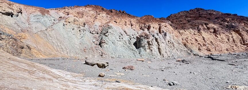
Mosaic Canyon Trail starts tight and gets tighter. Within the first quarter mile, the canyon walls close in around you, smooth polished marble worn down by thousands of years of flash floods, curving and twisting in shapes that look carved by hand. The geology here is legitimately extraordinary, and the trail takes you straight into the middle of it.
Quick Facts
| Trail Name | Mosaic Canyon Trail |
| Location | Death Valley National Park, California |
| Coordinates | 36.5638° N, 117.1331° W |
| Distance | 3.5 miles (out and back) |
| Elevation Gain | 984 ft |
| Difficulty | Moderate |
| Time | 2–3 hours |
| Dogs Allowed | No (pets not permitted on park trails) |
| Fee | $35 per vehicle (7-day pass) or America the Beautiful Pass |
| AllTrails | View on Alltrails |
How to Get There
Mosaic Canyon is accessed via Mosaic Canyon Road, which turns off CA-190 at Stovepipe Wells Village. The turnoff is clearly signed. From there, it’s 2.3 miles on a washboard dirt road to the trailhead. The road is accessible in most passenger vehicles, but it’s rough. High clearance helps. Low clearance isn’t a dealbreaker, but go slowly and watch the undercarriage on the rougher sections. Estes handles it without thinking about it.
From Furnace Creek, head west on CA-190 for about 25 miles to Stovepipe Wells. From the east entrance near Beatty, head west on CA-374 and connect to CA-190 toward Stovepipe Wells.
Death Valley National Park charges $35 per vehicle for a 7-day pass. The America the Beautiful Annual Pass covers entry. Pay at the entrance stations or in advance through recreation.gov.
Parking Information
The Mosaic Canyon trailhead has a small parking lot, roughly 20 to 25 vehicles. It fills quickly on weekends and holiday periods during the November to March peak season. Arrive early, before 8 a.m., to guarantee a spot and get into the canyon before the light gets harsh.
Restrooms are available at the trailhead. No water, no shade, no services beyond that. Everything you need comes with you.
If the lot is full, parking along the access road is possible, but adds distance to your hike. It’s not a long walk, but on a rough dirt road it’s not pleasant either.

Cell Service and Navigation
Cell service near Stovepipe Wells is unreliable and disappears entirely once you’re on the access road and inside the canyon. Don’t plan on having data or communication during this hike.
The trail is straightforward, an out-and-back through one canyon, so navigation isn’t a serious concern. Download offline maps before you leave and tell someone your itinerary. Death Valley emergency response is slow by necessity. Self-sufficiency matters more here than on most trails.
GPS satellite signal is reliable throughout the hike even without cell data.
What to Expect on Mosaic Canyon Trail
The first section of the trail is the payoff. The canyon narrows immediately and the walls close to just a few feet apart in places. The rock is polished dolomite marble, smoothed by centuries of flash floods into curves and bowls that catch light in ways that feel almost architectural. The color shifts between white, gray, and cream with streaks of darker rock running through it.
The canyon’s name comes from the mosaic breccia visible in sections of the wall, fragments of darker rock cemented into the lighter marble by ancient geological processes. Look for it as you move through the narrows. It’s easy to miss if you’re focused on footing.
This first narrow section is the most photographed and most visited part of the trail. If you’re here for the polished marble experience, you’ll get it in the first half mile. Most of what makes this trail memorable happens close to the trailhead.
Past the initial narrows, the canyon widens and the character changes. The walls pull back, the sky opens up, and the route gains more elevation as you move deeper. The terrain gets rougher here, with loose gravel, dry falls, and sections that require scrambling over boulders.
Most hikers reach the main dry fall at about 1.3 to 1.5 miles and turn around. Getting past it requires a scramble that some people find uncomfortable, nothing technical, but steep and exposed enough to give pause. If you make the move, the canyon continues with a second narrows section that sees far fewer visitors.
The upper section rewards commitment. The scenery changes again, wider views open up, and the crowds, such as they are, thin to nothing. If your legs and scrambling comfort are good, push past the dry fall.
Early morning light in the lower narrows is exceptional. The sun angle has to reach deep enough into the canyon to illuminate the polished walls, which happens later in the morning depending on the season. December and January mornings mean waiting until 9 or 10 a.m. for the narrows to light up. Spring and fall give you better early light.
The walls themselves act as natural reflectors, bouncing warm light around the interior of the canyon even when direct sun isn’t hitting them. Midday light is harder and less interesting for photography but perfectly functional for hiking. Sunset light hits the upper canyon walls on the way back if you time your return right.
Trail Difficulty and Length
Mosaic Canyon Trail is 3.5 miles out and back with 984 feet of elevation gain. It’s rated moderate, which is accurate. The lower narrows are easy walking. The upper canyon involves real elevation gain on loose terrain and optional scrambling at the main dry fall.
Footwear matters here. The polished marble is beautiful and genuinely slippery when dry. Wear trail shoes or hiking boots with solid rubber soles and good grip. Flip flops and sandals are a bad time in this canyon.
Budget 2 to 3 hours for the full out-and-back at a reasonable pace. Add time if you stop to photograph the narrows, which you will.
Dog Friendly?
No. Dogs are not permitted on Mosaic Canyon Trail or most trails within Death Valley National Park.
The terrain and heat conditions in Death Valley make it genuinely dangerous for dogs during much of the year regardless. Leave them somewhere cool and safe.

What to Bring
Desert canyon hiking in Death Valley requires real gear even in the cooler months.
Water first. Carry at least 2 liters per person for this hike. The dry air dehydrates you faster than the temperature suggests, especially inside the canyon where you’re working harder than you expect. A daypack with a hydration reservoir handles this cleanly.
Solid footwear is non-negotiable on this trail. The polished marble in the narrows is genuinely slippery. Trail runners or hiking boots with grippy rubber soles.
Sun protection for the exposed upper sections: sunscreen, hat, sunglasses. The canyon provides shade in the narrows but not above them.
For photography: a wide-angle lens for the canyon walls and compressed perspectives in the narrows, and a mid-range zoom for the upper canyon views. A headlamp if you’re going early enough that the trailhead is still dark. Bring extra memory cards. You’ll shoot more than you plan.
Best Time to Hike Mosaic Canyon Trail
November through March is the correct window for Death Valley hiking. Summer temperatures regularly exceed 120°F, and canyon terrain amplifies heat. Don’t hike here in summer.
Within the peak season, early morning is best. The lower canyon is cool and shaded, the parking lot is emptier, and the light arrives gradually into the narrows as the sun climbs. December and January mornings are cold enough for a jacket at the start. That’s fine. You warm up fast.
Weekdays are significantly less crowded than weekends throughout the November to March window. If your schedule allows any flexibility, go midweek and you’ll have the narrows largely to yourself.
For photography specifically, the first hour of light reaching the lower narrows is the money shot. Figure out the sunrise time for your visit, calculate when the sun will be high enough to reach into the canyon, and be there for it.

Rules and Regulations
Death Valley National Park rules apply throughout Mosaic Canyon.
Stay on the established route. The canyon walls and geological formations are fragile. Don’t carve, scratch, or mark the rock in any way.
Leave No Trace throughout. Pack out everything you pack in. No trash cans at the trailhead or on trail.
Dogs are not permitted. No drones without a permit. No fires.
Flash flooding is a real hazard in slot canyons. Check the National Weather Service forecast before hiking and do not enter the canyon if there is any chance of rain in the region, including rain far away that drains into the canyon system.
Where to Stay Near Mosaic Canyon
Stovepipe Wells Village is the closest accommodation, about 2 miles from the trailhead turnoff. The resort has hotel rooms and an adjacent campground. It’s basic but perfectly positioned for an early start.
Furnace Creek, about 25 miles east, is the park’s main hub with more lodging options including the historic Inn at Death Valley. For loyalty points in the gateway region, Marriott Bonvoy and Hilton Honors cover properties in Las Vegas (about 2 hours east) and Ridgecrest (about 2 hours west). IHG Rewards has options along the same corridors. Both cities are common staging points for multi-day Death Valley trips.
Camping Nearby
Stovepipe Wells Campground is adjacent to Stovepipe Wells Village and about 2 miles from the Mosaic Canyon turnoff. It’s a large campground with hookup options available. Reserve through Recreation.gov. Fills quickly on peak season weekends.
Emigrant Campground is about 9 miles south on CA-190, a free primitive campground with no hookups. First-come, first-served. Tents only. Good option if Stovepipe Wells is booked out.
Death Valley allows dispersed backcountry camping in designated areas at least 1 mile from paved roads and 100 yards from water sources and trails. A free permit is required. Check current conditions with the park before planning dispersed sites in this area of the valley.
Nearby Adventures
Mosaic Canyon puts you in a good position to hit several of Death Valley’s best spots in a single visit.
The Mesquite Flat Sand Dunes are about 2 miles east of Stovepipe Wells on CA-190. A completely different landscape, open desert and rolling sand instead of tight canyon walls. It’s a natural pairing with Mosaic Canyon if you have a full day.
Badwater Basin is about 40 miles south at Furnace Creek. The lowest point in North America and one of the strangest walks in the American West.
Artist’s Palette is a short drive loop near Furnace Creek where oxidized minerals paint the hillsides in green, yellow, pink, and purple. Late afternoon is the best time. My Artist’s Palette guide covers the details.
Dante’s View is a paved overlook at 5,575 feet with a view of the entire Death Valley basin, Badwater below and the Panamint Range across. No hiking required. See my Dante’s View guide for the best times to visit.
Golden Canyon and Gower Gulch Loop via Zabriskie Point is the park’s standout full-day hike, 6.4 miles with 1,082 feet of gain through badlands, canyon narrows, and some of the most otherworldly terrain in Death Valley. Save it for your second day.
Plan This Hike
AllTrails has Mosaic Canyon Trail mapped with user-reported conditions, recent reviews, and an offline map download. The trail is straightforward, but the road conditions on the 2.3-mile access road can vary after weather events. Recent user notes are useful for knowing what to expect before you arrive.
Download the offline map, read the recent reviews, and check Death Valley National Park’s website for any closures or road condition updates before you go. View on Alltrails.
Chase the Quiet
There’s a specific moment inside Mosaic Canyon, early, before anyone else has arrived, when the polished walls are still cold from the night and the canyon is completely silent, where you become genuinely aware of how old the rock around you is. The floods that carved these walls were doing this work millions of years before humans existed. Standing inside that is a particular kind of quiet. The impatient kind of brain I carry gets very still in places like that.
Support the Adventure
To make your walls less boring, check out my photography portfolio and bring a piece of the wild and my story into your home.
If you’d like to fuel future adventures, you can donate a coffee on Ko-Fi. Every cup keeps me chasing sunrises and stories.
When you shop using my affiliate links, every click helps support this blog at no extra cost to you. It’s a small way to keep Unicorn Adventure alive and kicking while I keep exploring.
Subscribe to my mailing list for future updates, new stories, and behind-the-scenes adventures.
Stay connected with me on Instagram and Facebook for more photos and daily inspiration.
Thanks for being part of the journey, Unicorn Squadron!

Theo Maynard is a landscape photographer and adventure blogger based in Salt Lake City. He chases remote desert and mountain light across the American West, documents it all solo, and shares the journey through Unicorn Adventure. He’s on the autism spectrum, and that’s not a footnote, it’s the whole story. He creates to inspire others to get outside, chase what lights them up, and live their best possible life. Unapologetically himself.