

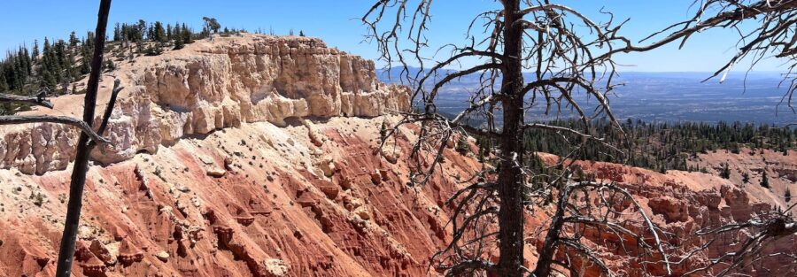
Most people never make it to Rainbow Point. They stop at Sunset Point, do the Navajo Loop, eat lunch in the car, and leave. Which is fine. But 18 miles south of the main entrance, past every crowd and every tour bus, Bryce Canyon quietly saves its best seat for whoever bothers to drive all the way to the end.
This guide covers everything you need to plan a clean visit to Bryce Canyon’s southern end.
Quick Facts
| Route Name | Rainbow Point, Yovimpa Point, and Bristlecone Loop |
| Location | Bryce Canyon National Park, Utah |
| Coordinates | 37.4753 N, 112.2396 W |
| Distance | 1.3 miles (loop + viewpoints) |
| Elevation Gain | 118 feet |
| Difficulty | Easy |
| Time | 2 hours |
| Dogs Allowed | No |
| Fee | National park entrance fee required (America the Beautiful pass accepted) |
| View on AllTrails | |
How to Get There
Rainbow Point is at the far southern end of Bryce Canyon National Park, 18 miles from the main park entrance on UT-63. The road runs straight through the park, and the drive itself is worth doing slowly. Multiple overlooks line the route and each one earns a stop.
From Salt Lake City: Head south on I-15, exit at UT-20 East, then south on US-89. Pick up UT-12 East near Panguitch, follow it to UT-63 South into the park, and continue all the way to the road’s southern terminus at Rainbow Point. About five hours total.
From Las Vegas: Take I-15 North to UT-20 East, then US-89 South to UT-12 East. UT-63 South takes you into the park. Drive the full length to the southern end. Around three and a half to four hours.
From Zion National Park: UT-9 East to US-89 North, then UT-12 East and UT-63 South into the park. About an hour and a half to two hours.
The main park road is paved and well-maintained. It closes periodically in winter after heavy snowfall, so check NPS road conditions before making the drive in the off-season.
Parking Information
The Rainbow Point parking lot sits right at the trailhead at the end of the main park road. It’s a large lot and generally has space even during busy periods, because most visitors don’t make the full drive south. Summer mornings and holiday weekends are the exception, so early arrival is still the smart call.
The park shuttle does not serve Rainbow Point. You need your own vehicle to get here. That’s part of why it stays quiet.

Cell Service and Navigation
Cell service in the southern end of Bryce Canyon is unreliable across most carriers. Don’t count on navigation or data once you’re in the park, and especially not down in the canyon if you venture off the viewpoints.
Download offline maps before you leave. AllTrails Pro handles this well. The route to Rainbow Point is straightforward, just follow UT-63 south to its terminus, but having offline access to trail maps is good practice for any national park visit.
What to Expect at Rainbow Point, Yovimpa Point, and the Bristlecone Loop
Rainbow Point
Rainbow Point is the highest viewpoint in Bryce Canyon at 9,115 feet. The panoramic view from the rim looks north across the full sweep of the Bryce Amphitheater, with the layered geology of the Grand Staircase extending to the south. On a clear day you can pick out the Kaibab Plateau and the elevated rim of the Grand Canyon on the horizon.
The viewpoint has interpretive signage explaining the geological sequence visible from the rim. The color banding, pink, white, gray, and orange, represents different sedimentary layers laid down over millions of years. It’s the clearest read of Bryce’s geology you’ll get from any single overlook.
Yovimpa Point
Yovimpa Point is a short walk from Rainbow Point, connected by a well-maintained paved path. The view here tilts south, looking out across the Grand Staircase-Escalante toward the Arizona border. It’s a different orientation than Rainbow Point and worth the five minutes to reach it.
The Grand Staircase visible from here represents one of the most complete records of geological time on the planet. The descending color bands, pink, grey, white, and vermilion, step down toward the Colorado River drainage system. Standing at Yovimpa and seeing this laid out below you is a perspective-adjuster.
The Bristlecone Loop
The Bristlecone Loop is a 1.3-mile loop trail that connects the two viewpoints and winds through forest along the rim. The trail is well-marked, paved in sections, and rated easy. It’s accessible for most visitors, including families with younger kids.
The draw on this loop is the bristlecone pines. Bryce Canyon sits at the edge of their range, and the trees along this trail are ancient, gnarled, and photogenic in the way that very old living things tend to be. Some of these trees are over a thousand years old. They grow slowly at elevation, their twisted forms shaped by centuries of wind and thin soil.
The light on the rim changes fast, especially in the morning and late afternoon. If you’re here for photography, walk the loop in both directions and hit the viewpoints at different angles.

Trail Difficulty and Length
The Bristlecone Loop runs 1.3 miles with 118 feet of elevation gain. Easy difficulty. This is the most accessible hiking in Bryce Canyon, and that’s not a knock against it. The payoff-to-effort ratio here is exceptional.
The viewpoints themselves are paved and require minimal walking from the parking lot. The loop trail has some gentle grade changes but nothing technical. Take your time. The views deserve it.
Budget one to two hours for the full experience: both viewpoints plus the complete loop. Longer if you’re photographing seriously or sitting with the view.
Dog Friendly?
No. Dogs are not permitted on the Bristlecone Loop or most trails in Bryce Canyon National Park. Leashed pets are allowed on paved surfaces and the Rim Trail between Sunrise and Sunset Points, but that’s the northern section of the park, not this area.
If you’re traveling with a dog, plan for them to stay at camp or in the vehicle while you explore Rainbow Point. The parking lot has shade trees that make this less terrible in cooler conditions.

What to Bring
Even on an easy trail at 9,000 feet, the elevation changes things. UV exposure is significantly higher up here, and the temperature can swing 20 degrees between morning and afternoon.
Carry at least a liter of water per person. Bring sun protection, hat, sunscreen, and sunglasses. A light wind layer is worth having even in summer. The rim catches wind that the canyon floor doesn’t, and afternoon thunderstorms in July and August can move in quickly.
Best Time to Visit Rainbow Point and the Bristlecone Loop
Late spring through early fall is the primary window. May and September are ideal, cool temperatures, manageable crowds, and excellent light. Summer is busy in the northern sections of the park but noticeably quieter at Rainbow Point.
Sunrise from Rainbow Point is worth setting an alarm for. The amphitheater catches the first light in the east and the warm morning glow on the hoodoos from this elevation is different from anything you’ll see at the lower overlooks. Sunset works too, with the Grand Staircase going amber and purple to the south.
Winter visits are possible but require preparation. The road stays open in most conditions but can close after significant snowfall. Snow on the rim and in the bristlecone pines creates genuinely striking photography opportunities. Bring microspikes if there’s any recent precipitation.
Bryce Canyon’s dark skies are world-class, and the southern end of the park is away from the visitor center light concentration. If you’re staying nearby, come back after dark.
Rules and Regulations
A valid entrance pass is required to enter Bryce Canyon National Park. The per-vehicle fee is $35 for a seven-day pass. The America the Beautiful Annual Pass covers entry and pays for itself quickly if you visit multiple national parks in a year.
Stay on designated trails. The terrain around Rainbow Point includes fragile soil ecosystems. Off-trail movement causes damage that takes decades to repair.
Pack out everything. Leave No Trace applies throughout the park. Drones are prohibited. Fires are restricted to designated areas and are subject to seasonal restrictions. Feed no wildlife.
Where to Stay Near Bryce Canyon
The town of Bryce Canyon City just outside the park entrance has several lodging options and is the most convenient base for exploring the park’s full length, including the drive to Rainbow Point. Panguitch to the north and Kanab to the south are both about an hour out with more variety.
For Marriott stays, search Marriott Bonvoy properties in Cedar City, about an hour northwest, for the most reliable chain hotel selection near the park.
IHG Rewards members can check IHG properties near Panguitch or Cedar City for points redemption. Cedar City has the widest selection.
Hilton Honors travelers should search Hilton properties in St. George, about two hours southwest. Pairing Bryce with Zion makes this a natural home base.
The Lodge at Bryce Canyon inside the park is the closest option for multiple days in the park and books out months in advance for summer. If that’s on your list, plan early.
Camping Nearby
North Campground and Sunset Campground operate inside Bryce Canyon National Park. North Campground is open year-round near the visitor center. Sunset Campground closes in winter. Both fill fast in summer. Book through Recreation.gov as early as reservations open.
For camping closer to the southern end of the park, the Dixie National Forest borders Bryce Canyon on multiple sides and allows dispersed camping outside designated campground boundaries. The forest land south and east of the park has accessible BLM land as well. Check current regulations with the Escalante Interagency Visitor Center before heading out. Conditions and restrictions change seasonally.
Kings Creek Campground in the Dixie National Forest, about 10 miles from Rainbow Point, is a quieter developed option with basic amenities and a less competitive reservation situation than the park campgrounds.
Nearby Adventures
The Tower Bridge Trail is one of the best hikes in the park for serious terrain, 3.6 miles and 839 feet of gain with a natural arch formation that stops you in your tracks. It starts from Sunrise Point at the northern end of the park.
The Navajo Loop and Queens Garden Trail gives you the heart of the Bryce Amphitheater, 3.0 miles through the densest hoodoo corridor in the park. Classic pairing with a Rainbow Point visit.
Agua Canyon, about 5 miles north of Rainbow Point along the main park road, has two of the most photographed hoodoos in Bryce: The Hunter and The Rabbit. Worth stopping on the drive back north.
About 45 minutes southeast, Kodachrome Basin State Park offers sandstone chimney formations and wide desert terrain in a much quieter setting. A natural add-on to a Bryce trip.
Bryce Canyon’s ranger-led astronomy programs run through summer and take advantage of some of the darkest skies in the lower 48. If you’re spending a night near the park, the night sky program is worth building your schedule around.
Plan This Hike
Get trail maps, current conditions, user reviews, and offline downloads for Rainbow Point and the Bristlecone Loop on AllTrails: View on Alltrails.
AllTrails makes it easy to download maps offline before you go, which matters anywhere cell service is unreliable. The review feed gives you recent condition reports from hikers who’ve been out in the last week. Useful for checking snow conditions in the off-season or road closures after storms.
Chase the Quiet
There’s something about going all the way to the end of the road that changes how you see a place. Rainbow Point isn’t a secret exactly, it’s on the map. But it sits at the end of 18 miles that most people don’t drive, past every popular stop, past where the shuttle turns around, past the point where crowds thin out and the park stops performing for visitors and just exists. That’s the version I want.
Support the Adventure
To make your walls less boring, check out my photography portfolio and bring a piece of the wild and my story into your home.
If you’d like to fuel future adventures, you can donate a coffee on Ko-Fi. Every cup keeps me chasing sunrises and stories.
When you shop using my affiliate links, every click helps support this blog at no extra cost to you. It’s a small way to keep Unicorn Adventure alive and kicking while I keep exploring.
Subscribe to my mailing list for future updates, new stories, and behind-the-scenes adventures.
Stay connected with me on Instagram and Facebook for more photos and daily inspiration.
Thanks for being part of the journey, Unicorn Squadron!

Theo Maynard is a landscape photographer and adventure blogger based in Salt Lake City. He chases remote desert and mountain light across the American West, documents it all solo, and shares the journey through Unicorn Adventure. He’s on the autism spectrum, and that’s not a footnote, it’s the whole story. He creates to inspire others to get outside, chase what lights them up, and live their best possible life. Unapologetically himself.