

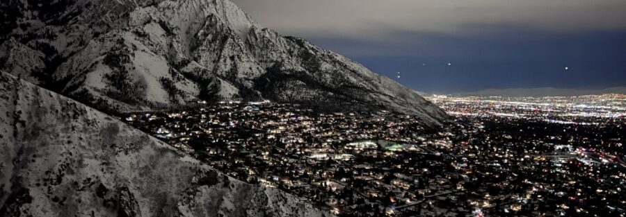
Millcreek Canyon is the most dog-friendly canyon on the Wasatch Front. Rattlesnake Gulch is one of its best hikes. Rattlesnake Gulch sits about 2.3 miles up Millcreek Canyon Road from the canyon entrance, a short drive from Salt Lake City. The trail covers 4.2 miles round trip with 1,200 feet of gain through pine and aspen forest before opening to views of Mount Olympus, the Salt Lake Valley, and the Wasatch peaks. It’s a real hike without being an all-day commitment, and the dog-friendly access makes it one of the most popular canyon routes for locals who want to bring a dog along without planning around watershed restrictions. I live in Salt Lake City and I’ve done this trail on evenings when I need to get out of the house without a full-day production. It delivers in about three hours. The views are better than the mileage suggests. Here’s what you need to hike Rattlesnake Gulch.
Quick Facts
| Trail Name | Rattlesnake Gulch Trail |
| Location | Millcreek Canyon, Salt Lake City, Utah |
| Coordinates | 40.6918, -111.7690 |
| Distance | 4.2 miles (round trip) |
| Elevation Gain | 1,200 feet |
| Difficulty | Moderate |
| Time | 2.5-4 hours |
| Dogs Allowed | Yes (off-leash odd days, on-leash even days) |
| Fee | $5/day or $50/year (Millcreek Canyon) |
| View on Alltrails | |
How to Get There
From Salt Lake City, head east on 3900 South to Wasatch Boulevard. Turn left on Wasatch Boulevard and right onto Millcreek Canyon Road. Drive approximately 2.3 miles up the canyon to the Rattlesnake Gulch trailhead on the left side of the road. The canyon entrance is well-signed from Wasatch Boulevard. Drive time from downtown Salt Lake City is about 20 to 25 minutes. A day-use fee is collected at the canyon entrance. The canyon road is paved and accessible in a standard vehicle year-round in most conditions.
Parking Information
The trailhead has a small parking pullout that fills fast on weekend mornings in spring and fall. If it’s full, additional pullouts run further up the canyon road. Arrive before 8 a.m. on busy weekends. The canyon charges $5 per day or $50 for an annual pass, collected at self-service stations near the canyon entrance. No restrooms at the Rattlesnake Gulch trailhead specifically; facilities are available further up the canyon at Millcreek picnic areas. 
Cell Service and Navigation
Cell service in Millcreek Canyon is inconsistent and degrades as you gain elevation and move further from the canyon mouth. Download your map offline through AllTrails before leaving. The trail is well-marked and the canyon terrain provides clear navigation reference, but having a track loaded removes any uncertainty at junctions. Weather on the upper exposed sections builds faster than you’d expect from a front-range canyon. Check the forecast and watch for afternoon storm development in summer.
What to Expect on Rattlesnake Gulch Trail
The Forest Ascent
The trail starts from the canyon road pullout and climbs immediately into pine and aspen forest. The lower section is shaded and the gradient is manageable, with a consistent ascent that doesn’t punish early on. The forest stays dense through the mid-section, providing shade and keeping the trail cool even on warm canyon days. Wildlife is active in here, particularly in the early morning. Watch for deer on the lower slopes and listen for birds in the aspen canopy.
The Upper Trail and Views
The trees thin as you gain elevation and the trail opens to views of the Salt Lake Valley. Mount Olympus appears to the south, rising above the canyon ridgeline. The upper trail is more exposed, with rocky outcrops and meadow sections replacing the dense forest below. The panorama from the upper trail spans the valley to the west, the Oquirrh Mountains on the far side, and the Great Salt Lake on clear days. The high point of the trail delivers the full Wasatch Front view before the descent back through the forest. 
Trail Difficulty and Length
Rattlesnake Gulch is 4.2 miles roundtrip with 1,200 feet of elevation gain. The moderate rating is accurate for fit hikers. The elevation gain is steady and the upper exposed section pushes the effort. Budget 2.5 to 4 hours depending on pace and how long you linger at the top.
Dog Friendly?
Yes, and this is one of the main reasons Rattlesnake Gulch gets the traffic it does. Millcreek Canyon has a unique odd/even day dog policy. On odd-numbered calendar days dogs are allowed off-leash on the trail. On even-numbered days leashes are required throughout. Check the date before you go. No watershed restriction here like Big and Little Cottonwood, so dogs are welcome any day. Bring more water than you think your dog needs. There are no reliable water sources on trail and the upper exposed sections heat up.
What to Bring
At least 2 liters of water per person. The gain drains you and the upper exposed section accelerates it in warm weather. Sunscreen and a hat for the open upper trail. Trail shoes or hiking boots with grip for the rocky upper sections. A light layer for the upper exposed ridge where wind can cut cold even on warm days. Trekking poles help on the descent with 1,200 feet to come back down. A camera for the valley views. The Mount Olympus angle from the upper trail is a good shot with the valley spread below it.
Best Time to Hike Rattlesnake Gulch
Spring (April through June) and fall (September through October) are the best windows. The canyon wildflowers peak in late spring and the aspen turns brilliantly in fall, making the forest section particularly strong in October. Summer is hot on the upper exposed sections but the forested lower trail stays relatively cool. Start before 8 a.m. in summer. Winter keeps the trail accessible in most years, with packed snow on the upper sections requiring microspikes for safe footing on the descent. For photography, early morning on clear days is the move for valley views. The light hits the Wasatch peaks from the east before it washes out on the valley floor. Mount Olympus from the upper trail with the valley in the frame photographs best with a 24-70mm range. Fall color in the aspen section peaks in late September and early October and looks best on overcast days when the light is even. 
Rules and Regulations
Rattlesnake Gulch is managed by Salt Lake County as part of Millcreek Canyon. A canyon access fee applies: $5 per day or $50 for an annual pass. Dogs allowed with the odd/even day policy. Leave No Trace applies fully. Stay on the marked trail to prevent erosion on the steep upper sections. Bikes are allowed on some Millcreek Canyon trails but not Rattlesnake Gulch, which is hiker and dog traffic only. Check the Salt Lake County Millcreek Canyon page for current conditions, fire restrictions, and any seasonal closures before heading out.
Where to Stay Near Salt Lake City
Salt Lake City has full lodging coverage within 20 to 30 minutes of the Millcreek Canyon entrance. For hotel points check Marriott Bonvoy, IHG Rewards, and Hilton Honors. The Millcreek and Cottonwood Heights neighborhoods are 5 to 10 minutes from the canyon mouth and eliminate most morning drive time.
Camping Nearby
Millcreek Canyon has established campgrounds including the Terraces Campground further up the canyon road. Reservable through recreation.gov and fills on summer weekends. The canyon also has picnic areas with tables and fire grates for day use. Big Cottonwood Canyon, one canyon south, has Redman Campground as an alternative established option.
Nearby Adventures
Millcreek Canyon has strong options above and around Rattlesnake Gulch. The Pipeline Trail runs the length of the canyon and connects multiple trailheads, making it the go-to for longer mileage or trail runs. Grandeur Peak is the canyon’s big summit objective at around 6.6 miles and 2,600 feet of gain, one of the best front-range peak views in the Wasatch. The Desolation Trail pushes to the Salt Lake Overlook with sustained ridge views that reward the longer commitment. One canyon south, Big Cottonwood Canyon has Lake Blanche as the marquee alpine lake hike at 6.2 miles and roughly 2,800 feet of gain. Mount Olympus, visible from the Rattlesnake Gulch upper trail, is a 6.9-mile strenuous climb to the summit. One canyon north, the Avenues foothills have Jack’s Mountain (2.5 mi / 1,300 ft) and Avenue Twin Peaks (4.0 mi / 1,600 ft) for additional Wasatch Front options close to the city. Off the trail, Millcreek Canyon is popular for mountain biking, picnicking, and cross-country skiing in winter. Salt Lake City proper has the Natural History Museum of Utah, Red Butte Garden, and a solid restaurant scene in neighborhoods like Sugar House and 9th and 9th within 15 minutes of the canyon.
Plan This Hike
AllTrails has Rattlesnake Gulch with a downloadable map, recent user conditions, and notes on current trail state from other hikers. Checking recent reports is useful for understanding snow on the upper trail in early spring and current canyon access conditions. View on Alltrails AllTrails Pro is worth it for offline maps in Millcreek Canyon where cell signal is unreliable. Download maps before you lose signal near the canyon entrance.
Chase the Quiet
Millcreek Canyon from the Rattlesnake Gulch upper trail is one of those views that earns the drive and the elevation without asking too much of either. Mount Olympus to the south, the valley spread west, the Great Salt Lake on a clear day. It’s a front-range view that most people don’t know about because the trailhead doesn’t get the marketing that Calf Creek or Zion get. That’s fine. The parking is easier and the trail is quieter for it.
Support the Adventure
To make your walls less boring, check out my photography portfolio and bring a piece of the wild and my story into your home. If you’d like to fuel future adventures, you can donate a coffee on Ko-Fi. Every cup keeps me chasing sunrises and stories. When you shop using my affiliate links, every click helps support this blog at no extra cost to you. It’s a small way to keep Unicorn Adventure alive and kicking while I keep exploring. Subscribe to my mailing list for future updates, new stories, and behind-the-scenes adventures. Stay connected with me on Instagram and Facebook for more photos and daily inspiration. Thanks for being part of the journey, Unicorn Squadron!

Theo Maynard is a landscape photographer and adventure blogger based in Salt Lake City. He chases remote desert and mountain light across the American West, documents it all solo, and shares the journey through Unicorn Adventure. He’s on the autism spectrum, and that’s not a footnote, it’s the whole story. He creates to inspire others to get outside, chase what lights them up, and live their best possible life. Unapologetically himself.