

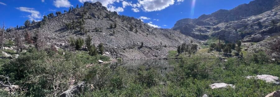
Angel Lake is the kind of place that stops you before you even start hiking. The road off I-80 outside Wells, Nevada, climbs 12 miles from the interstate into the East Humboldt Range and deposits you at an alpine lake sitting at 8,500 feet with granite peaks closing in on three sides. Most visitors park there, walk around the lake, and call it a day. That’s a legitimate choice. But the Smith Lake Trail starts at that same parking area and climbs another 800 feet in 1.25 miles to a higher cirque lake that sees a fraction of the Angel Lake traffic. I stopped at Angel Lake on an I-80 transit trip, planning for an hour. The Smith Lake trail was right there on the sign at the trailhead. I took it. When something presents itself cleanly as the obvious next step, I tend to follow it. That sign was a very clean next step. Smith Lake sits in a granite bowl above Angel Lake’s treeline with views that don’t bother pretending to be modest. Two lakes, 2.5 miles roundtrip, and a mountain experience that most I-80 drivers don’t know is a 12-mile detour from Exit 352. This guide covers the Smith Lake via Angel Lake Trail: what the approach to Angel Lake involves, what the climb to Smith Lake is actually like, and how to build the day from Wells or from the road.
Quick Facts
| Trail Name | Smith Lake via Angel Lake Trail |
| Location | Angel Lake, East Humboldt Range, Wells, Nevada |
| Coordinates | 41.0266° N, 115.0870° W |
| Distance | 2.5 miles roundtrip |
| Elevation Gain | ~800 feet |
| Difficulty | Moderate |
| Time | 2–3 hours |
| Dogs Allowed | Yes, on leash |
| Fee | None (National Forest land) |
| AllTrails | View on AllTrails |
How to Get There
From I-80, take Exit 352 for Wells, Nevada. From Wells, head south on US-93 for about 8 miles, then turn right onto Angel Lake Road (SR 231). Follow Angel Lake Road approximately 12 miles as it climbs into the East Humboldt Range. The road ends at the Angel Lake Campground and day use area. The Smith Lake trailhead is at the end of this parking area. The Angel Lake Road drive is part of the experience. The road climbs from high desert through juniper and pinyon, then into the granite terrain of the East Humboldt Range. By the time you reach the lake at the end, you’re well above the basin and the views back toward Wells and the desert flats are already worth stopping for. From Salt Lake City, Wells is about 2.5 hours west on I-80. From Reno, approximately 4 hours east. The trailhead is 20 miles and about 30-35 minutes from the Wells I-80 exit. This is one of the most accessible alpine hiking destinations from the I-80 corridor in Nevada.
Parking Information
Parking is available at the Angel Lake Campground day use area at the end of Angel Lake Road. The lot is free for hikers in some seasons but a day use fee has applied historically during peak operation. Check current rates with the Humboldt-Toiyabe National Forest before your visit, as fees and operating periods change seasonally. Restrooms are available at the campground. The lot fills on summer weekends when Angel Lake itself draws picnickers and casual visitors in addition to hikers. Arrive before 9 a.m. on weekends to be safe. Weekday mornings are significantly quieter. 
Cell Service and Navigation
Cell coverage drops on Angel Lake Road above the valley floor and is absent at the trailhead. Download AllTrails or another navigation app offline in Wells or on I-80 before turning onto Angel Lake Road. The Smith Lake trail is well-marked from the Angel Lake trailhead. The climb is direct and the route is cairned on the rocky sections above the lake. Having GPS active is useful on the upper rocky terrain where the trail can be less distinct, but navigation isn’t the primary challenge here. The lake basin at the top is clearly the endpoint.
What to Expect on the Smith Lake via Angel Lake Trail
The starting point is Angel Lake itself, one of the most accessible alpine lakes in Nevada. The lake sits at 8,500 feet with granite peaks and talus slopes closing in on the upper three sides. A rough trail circles the lake and most visitors walk it before or after heading to Smith Lake. It’s worth the 20 minutes. The lake surface reflects the granite walls above in morning light. Wildflowers grow in the meadow areas around the outlet and the flat rock sections make good photography platforms in the early hours before the day use crowd arrives. In summer, the campground adjacent to the lake fills quickly and the day use area gets busy by mid-morning. The Smith Lake trail leaves the Angel Lake area and climbs steeply up the talus and boulder field above the lake’s back wall. This section earns the moderate rating: it’s short but it’s steep, and the footing on loose rock requires attention. The elevation gain of 800 feet in 1.25 miles is felt. The talus climb is the technical crux of the hike. Hiking boots with real ankle support and grip are the correct footwear. Trail runners work for confident hikers comfortable on uneven rock, but boots are the safer call. Trekking poles help significantly on both the ascent and the descent, especially if you’re less experienced on talus terrain. The upper section levels as you gain the rim of the Smith Lake cirque. The lake appears immediately below the crest, smaller and more intimate than Angel Lake, sitting in a tight granite bowl with walls on three sides and no campground, no day use area, and typically far fewer people. Smith Lake is the payoff. The cirque walls rise steeply above the lake on three sides and the view back down toward Angel Lake and out over the Wells basin fills the open side. The water is clear and cold. The rock sections around the shoreline are flatter and more accessible than they appear from the trail approach. For photography, the morning window before 10 a.m. gives you direct light on the upper cirque walls and the lake reflection below. The tight granite bowl concentrates and amplifies the light in early morning in a way that produces strong shots of the lake and surrounding peaks. A wide-angle lens works well from the lake shore; a mid-range captures the cirque detail from across the water.
Trail Difficulty and Length
Moderate is accurate, with the caveat that the talus climb is the hardest section and it comes concentrated in the upper half of a short trail. The 2.5-mile roundtrip is short enough for most hikers to complete in 2-3 hours, but the 800 feet of gain on loose rock requires real effort. This isn’t a casual walk up a maintained forest trail. The trailhead at Angel Lake sits at approximately 8,500 feet. Smith Lake is near 9,300 feet. Hikers not acclimatized to elevation may find the talus climb harder than the distance suggests. Take it slow and let the terrain dictate pace. 
Dog Friendly?
Yes. The trail is on National Forest land and dogs are welcome on leash. Angel Lake itself provides water access before the climb. The talus section requires dogs that are comfortable and confident on uneven rocky terrain. Small dogs and dogs not experienced on talus may struggle on the upper boulder field. Assess honestly before committing your dog to the climb. Bring water for dogs for the talus section since the trail is dry above Angel Lake until you reach Smith Lake. Keep dogs leashed near the lake shoreline at both Angel Lake and Smith Lake. Pack out waste throughout.
What to Bring
Hiking boots with ankle support and real grip for the talus section. Trekking poles. Water from Wells or filled at the Angel Lake campground: 2 liters per person minimum. The climb is short but the elevation and rocky terrain are dehydrating. Layers: Angel Lake at 8,500 feet runs cold in the morning even in July. Wind picks up on the talus section above the lake. A rain shell is worth carrying since afternoon storms can build quickly in the East Humboldt Range in summer. Sun protection for the exposed talus climb. For photography: wide-angle for Smith Lake and the Angel Lake reflection from the rim, mid-range for the cirque walls and peak detail, trekking poles that double as tripod legs for stability on rocky terrain. Morning is the priority lighting window at both lakes. 
Best Time to Hike Smith Lake via Angel Lake Trail
Late June through September is the reliable window. Angel Lake Road typically opens by late May or early June, but the talus field above Angel Lake can hold snow patches into late June in heavy snow years. Check conditions with the Humboldt-Toiyabe National Forest Jarbidge Ranger District before going in early season. July brings peak wildflower season in the meadow areas around Angel Lake and the upper basin approaches. It also brings the most afternoon thunderstorm activity. Start early and plan to be off the exposed talus by noon if storms are in the forecast. The upper talus above Angel Lake has no shelter. September is the best overall month. Fewer people, cooler temperatures, and the aspens around the lower sections of Angel Lake Road and in the Wells basin turn gold by mid-month. Fall color on the drive in adds a separate photo opportunity to the alpine lake experience. For photography: arrive at Angel Lake at or before sunrise for the morning light on the granite walls and lake reflection. Climb to Smith Lake by 9-10 a.m. for the best light on the upper cirque before the overhead glare arrives.
Rules and Regulations
No campfires in the East Humboldt Wilderness and the Angel Lake area. Pack a stove. Pack out all trash and dog waste. Stay on the trail in the meadow sections below the talus to protect alpine vegetation. On the talus climb, walk on rock surfaces rather than soil or plant communities between boulders. Do not build new cairns or move existing ones. Camping is available at the Angel Lake Campground with reservations through recreation.gov. The campground has designated sites and facilities. Dispersed camping in the wilderness area requires following Leave No Trace principles including the 200-foot setback from water sources.
Where to Stay Near Wells
Wells is the nearest town, about 20 miles from the trailhead at Exit 352 on I-80. It has limited but functional lodging for an I-80 corridor stop. Elko, 50 miles west, has more options at every price point.
Camping Nearby
Angel Lake Campground is the obvious choice. It sits at the lake at 8,500 feet with tent and RV sites and basic facilities. It operates seasonally, typically June through September, with reservations through recreation.gov. Camping at the lake means a zero-drive morning start to Smith Lake before the day use crowd arrives, which is genuinely worth the reservation effort. Dispersed camping in the East Humboldt Wilderness is permitted at established sites with the standard Leave No Trace rules. Check current regulations with the Jarbidge Ranger District of Humboldt-Toiyabe National Forest before planning an overnight stay in the backcountry.
Nearby Adventures
The Angel Lake to Winchell Lake Trail extends beyond Smith Lake into the East Humboldt Range for a longer, more challenging option. Winchell Lake is a more remote destination above Smith Lake that requires additional elevation gain and route-finding confidence. It’s the natural extension for hikers who find Smith Lake too short. The Ruby Mountains and Lamoille Canyon routes near Elko, 50 miles west, offer the three Ruby Mountains hikes: Liberty Lake Trail, Island Lake Trail, and Thomas Creek Trail. These make natural companions on a multi-day Nevada mountain itinerary. The Ruby Marshes Wildlife Management Area south of Elko offers birding and wildlife viewing in a Great Basin wetland environment, a completely different Nevada landscape from the granite East Humboldt Range. In Wells: the Wells Historical Society Museum covers the town’s California Trail history. The town has basic services for an I-80 stop. Elko has the full range of dining and cultural options including the Northeastern Nevada Museum, Western Folklife Center, and the Star Hotel for Basque food.
Plan This Hike
AllTrails has Smith Lake via Angel Lake Trail mapped with offline capability and condition reports. Download before you leave Wells or before turning onto Angel Lake Road. Plan your hike on AllTrails and pull the offline map while you’ve still got signal near Wells.
Chase the Quiet
Most people driving I-80 through Wells don’t know Angel Lake exists. Of those who drive up to it, most don’t know Smith Lake is another 1.25 miles and 800 vertical feet above. That’s the version of this place worth making the detour for. The granite cirque at Smith Lake belongs to whoever walks up the talus to reach it, and on most mornings that’s a small number of people. The East Humboldt Range has been sitting east of Elko not caring about its reputation for a long time. It doesn’t need to advertise.
Support the Adventure
To make your walls less boring, check out my photography portfolio and bring a piece of the wild and my story into your home. If you’d like to fuel future adventures, you can donate a coffee on Ko-Fi. Every cup keeps me chasing sunrises and stories. When you shop using my affiliate links, every click helps support this blog at no extra cost to you. It’s a small way to keep Unicorn Adventure alive and kicking while I keep exploring. Subscribe to my mailing list for future updates, new stories, and behind-the-scenes adventures. Stay connected with me on Instagram and Facebook for more photos and daily inspiration. Thanks for being part of the journey, Unicorn Squadron!

Theo Maynard is a landscape photographer and adventure blogger based in Salt Lake City. He chases remote desert and mountain light across the American West, documents it all solo, and shares the journey through Unicorn Adventure. He’s on the autism spectrum, and that’s not a footnote, it’s the whole story. He creates to inspire others to get outside, chase what lights them up, and live their best possible life. Unapologetically himself.