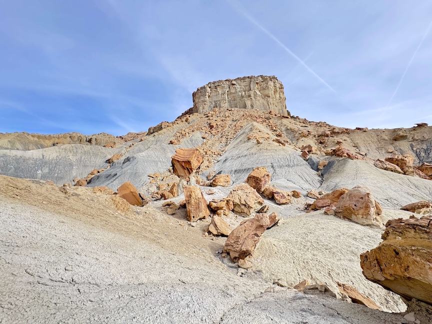
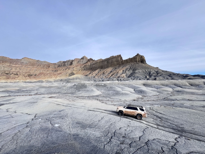
Smoky Mountain Road runs 77 miles between Big Water, Utah (near Page, Arizona on US-89) and Escalante, Utah (on UT-12), crossing through some of the most remote and visually dramatic BLM land in the Colorado Plateau. The road passes through broad desert flats, descends into carved canyon systems, climbs steep ridgelines with the desert visible in every direction, and transitions from white and pink sandstone in the south to darker volcanic rock formations in the north. No gas stations, no quick exits, no cell service for most of it. High-clearance 4WD and self-sufficiency are the requirements.
Quick Facts
|
Route Name |
Smoky Mountain Road |
|
Location |
BLM land / Glen Canyon NRA, between Big Water, Utah and Escalante, Utah |
|
Southern Start |
|
|
Northern Start |
|
|
Distance |
~77 miles one-way (typically driven as a day trip one-way or roundtrip from one end) |
|
Elevation Gain |
Variable; significant topographic changes throughout |
|
Drive Difficulty |
Moderate (high-clearance 4WD required; northern half rougher; Kelly Grade requires careful driving) |
|
Time |
4-7 hours one-way at a careful pace with stops |
|
Dogs Allowed |
Yes, on leash |
|
Fee |
None |
How to Get There
The southern access point is in Big Water, Utah, just off US-89 about 15 miles west of Page, Arizona. The northern access is off UT-12 in or near Escalante, Utah, about 65 miles east of Bryce Canyon. Most drivers start from the south (Big Water) for the gradual climb and take advantage of the longer, smoother initial section before the more technical northern half. Both directions offer full completion of the route with appropriate end-to-end logistics (two vehicles or a shuttle).
From Page, Arizona: US-89 west approximately 15 miles to Big Water. From Salt Lake City: I-15 south to US-89 south through Kanab to Big Water, approximately 5 hours. From Bryce Canyon: UT-12 east to Escalante for the northern approach, approximately 30-40 minutes.
Vehicle Requirements
High-clearance 4WD is required for the full Smoky Mountain Road. The southern half from Big Water is relatively smooth packed dirt; the northern half deteriorates with rougher terrain, especially approaching Kelly Grade. Kelly Grade is the most technical section: a steep exposed climb along cliff edges that requires confident 4WD driving and care about both the road surface and the drop on the outside edge. Low-range 4WD is useful for Kelly Grade descents.
Wet conditions make Smoky Mountain Road impassable. The BLM dirt surface turns to mud that traps vehicles regardless of their capability. Always check weather for the entire corridor before driving. Do not start the route if rain is forecast anywhere along the 77-mile corridor.
Recovery gear: full recovery kit including tow straps, traction boards, shovel, full-size spare, tire repair kit. Satellite communicator (Garmin inReach or equivalent) for the extended sections with no cell coverage. Extra fuel if your vehicle doesn’t have the range for 77 miles of rough road; fuel consumption on 4WD dirt roads is significantly higher than highway.
Cell Service and Navigation
Cell coverage is present at the Big Water junction and in Escalante. The route itself has no coverage for most of its length. Download the offline maps for the full route before departing from either end. Note the locations of the major route features (Alstrom Point turnoff, Kelly Grade, any spur roads) before you lose coverage. A paper map of the Kane County / Garfield County BLM land is a useful backup.
What to Expect on Smoky Mountain Road
Southern Section: Big Water to Mid-Route
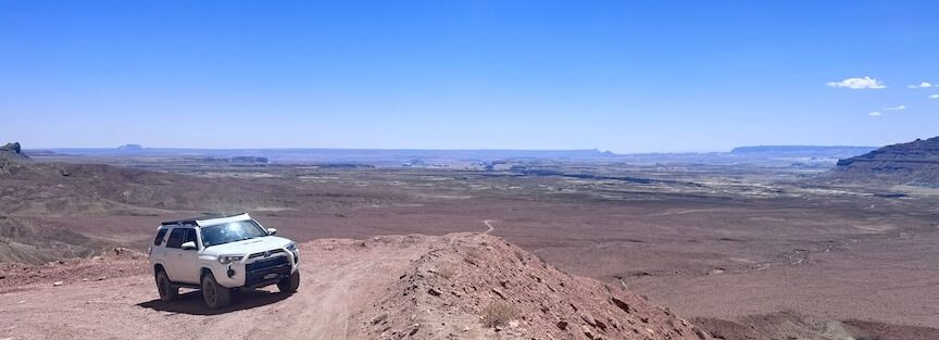
The southern section from Big Water is the more accessible half: packed dirt with rolling terrain, broad desert views, distant buttes, and the high desert landscape of the Kaiparowits Plateau edge. The Alstrom Point turnoff branches off this section, and the Crosby Canyon OHV route accesses Lake Powell from the same BLM road network near Big Water. The landscape is classic southern Utah high desert: sagebrush, juniper, red and pink sandstone, and the silence of an area without human infrastructure.
Pronghorn antelope and occasionally wild horses are present in this corridor. Slow down and watch the desert edges on both sides of the road in the early morning and late afternoon hours.
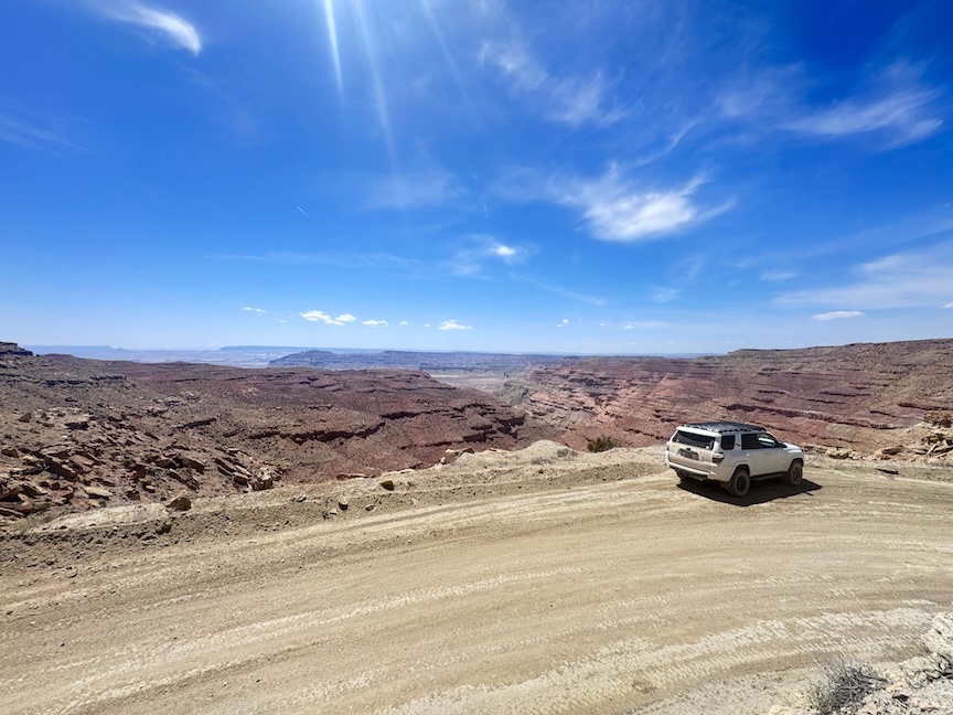
Northern Section: Kelly Grade and Escalante Approach
The northern half roughens significantly. The terrain becomes more dramatic with deeper canyon views and steeper road grades. Kelly Grade is the route’s defining technical section: a steep exposed shelf road along cliff edges where careful, slow driving and lane discipline matter. In dry conditions with a capable vehicle and an alert driver, Kelly Grade is manageable. In any other conditions, it demands full attention.
The rock transitions from the pale sandstone of the south to darker volcanic rock formations as you approach Escalante. The visual character of the landscape shifts noticeably and the road often provides ridgeline vantage points with views that extend far into the Escalante canyon system to the east.
The Route as an Expedition
Smoky Mountain Road is best understood as a driving expedition rather than a scenic drive. It requires planning (weather check, fuel check, recovery gear), a capable vehicle, and the willingness to turn around if conditions change. The 77-mile length makes it a commitment: once you’re 30+ miles from either end, you’re committed to completion or a long rough return. This is what makes it a genuine adventure rather than a highway experience: the self-reliance is real and the stakes of poor planning are real.
Drive Difficulty and Length
The route is 77 miles one-way and rated Easy to Moderate. The rating reflects the range: the southern section is genuinely easy in dry conditions for a capable high-clearance 4WD; Kelly Grade and the northern section earn the moderate end of the range. Experienced overland drivers handle the full route comfortably; anyone with limited off-road experience should research Kelly Grade specifically before committing to the northern section.
Dog Friendly?
Yes. Dogs are welcome on BLM land along the full route. The vehicle-based nature of most of the route is comfortable for road-trip dogs. Extended stops in direct sun require shade creation (vehicle shadow, a dog tent) and water. The desert heat on the unshaded road is the primary dog safety consideration. Bring more water than you think you need and schedule stops in shaded areas where available.
What to Bring
Full recovery gear: tow straps, traction boards, shovel, full-size spare, tire repair kit. Satellite communicator. Fuel with sufficient range (77 miles of rough road plus buffer from the junction at each end). Water: 4+ liters per person for a full-day route with no resupply. Food for the duration plus emergency supplies. A first aid kit. Emergency shelter if you’re camping. A headlamp in case the drive extends into darkness.
Camping Along Smoky Mountain Road
BLM dispersed camping is permitted throughout the Smoky Mountain Road corridor outside any designated restricted areas. Fully self-contained: pack in everything, pack out everything, bury waste 200 feet from road and water, no ground fires without checking current restrictions. The route is long enough that multi-day trips with camping along the road are a natural format for getting the full experience rather than rushing the drive in a single day.
Best Time to Drive Smoky Mountain Road
Spring (March through May) and fall (September through November) are the reliable windows. Mild daytime temperatures, no monsoon rain risk, and the best landscape photography light of the year.
Summer: the heat challenge is real. The route has no shade for most of its 77 miles. An early departure from Big Water (before 6 a.m.) and a return to paved road before midday is the practical summer approach. Afternoon summer driving on Smoky Mountain Road in 100°F+ heat is not recommended without extensive desert expedition preparation.
Winter: possible with reduced crowds and dramatic winter light, but snow and ice on Kelly Grade is a genuine danger and the northern section can become impassable in cold wet conditions. Check road conditions and forecasts carefully for any winter visit.

Rules and Regulations
BLM land and Glen Canyon NRA rules apply throughout. Stay on established roads. No off-road driving. Pack out all waste. No fires without verifying current restrictions. Camping permitted with Leave No Trace standards. Dogs on leash. No permits required for driving the route. No fee.
Where to Stay Near Big Water or Escalante
Big Water has limited services (gas, basic supplies) on US-89. Page, Arizona (15 miles east) has full chain hotel infrastructure. Escalante (north end) is a small town on UT-12 with independent lodging and limited services. For points travelers in Page, check available Marriott Bonvoy properties in Page, IHG Rewards hotels in Page, and Hilton Honors options in Page. Kanab, Utah, is about 30 miles west of Big Water on US-89.
Nearby Adventures
Alstrom Point branches off the southern section of Smoky Mountain Road near Big Water: a 25-mile one-way BLM road spur to a Lake Powell sunset overlook that is one of the best viewpoints in the Colorado Plateau. The Alstrom Point drive is often done as a separate day trip from the same Big Water base, or as a spur from the southern section of Smoky Mountain Road.
Crosby Canyon OHV is the other BLM route from the Big Water area: a canyon route to a Lake Powell beach, shorter and less demanding than Smoky Mountain Road but part of the same desert road network.
Escalante’s canyon country, accessible from UT-12 near the northern end of the route, includes the Hole-in-the-Rock Road, slot canyon hikes, and Grand Staircase-Escalante National Monument access points. Completing Smoky Mountain Road north-to-south and extending into the Escalante canyon area makes for a 2-3 day Colorado Plateau expedition loop.
Chase the Quiet
77 miles of BLM road with no gas, no cell service, no quick exit. The canyon country of southern Utah between the Kaiparowits Plateau and the Escalante canyon system is some of the most remote land in the lower 48. Smoky Mountain Road moves through the middle of it at a pace the terrain determines rather than you. Kelly Grade teaches that. The road decides how fast you go. The desert decides how small you are. That’s the specific thing a route like this delivers that a highway never can: the scale of the landscape at vehicle pace rather than streaming past at 80 miles per hour. The dust and the distance are the whole point.
Support the Adventure
To make your walls less boring, check out my photography portfolio and bring a piece of the wild and my story into your home.
If you’d like to fuel future adventures, you can donate a coffee on Ko-Fi. Every cup keeps me chasing sunrises and stories.
When you shop using my affiliate links, every click helps support this blog at no extra cost to you. It’s a small way to keep Unicorn Adventure alive and kicking while I keep exploring.
Subscribe to my mailing list for future updates, new stories, and behind-the-scenes adventures.
Stay connected with me on Instagram and Facebook for more photos and daily inspiration.
Thanks for being part of the journey, Unicorn Squadron!

Theo Maynard is a landscape photographer and adventure blogger based in Salt Lake City. He chases remote desert and mountain light across the American West, documents it all solo, and shares the journey through Unicorn Adventure. He’s on the autism spectrum, and that’s not a footnote, it’s the whole story. He creates to inspire others to get outside, chase what lights them up, and live their best possible life. Unapologetically himself.