

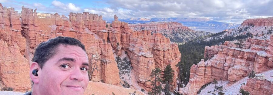
If you’re going to do one hike in Bryce Canyon National Park, make it this one. The combination of Wall Street, Queens Garden, and the Peekaboo Loop is 6.3 miles that covers more geological spectacle per step than almost any trail in southern Utah. You descend through a slot, cross a hoodoo amphitheater, loop through hidden corridors, and climb back out. It’s a full day in the canyon and it earns every minute.
Here’s your complete guide.
Quick Facts
| Trail Name | Wall Street, Queens Garden, and Peekaboo Loop |
| Location | Bryce Canyon National Park, Utah |
| Coordinates | 37.6227 N, 112.1661 W (Sunset Point trailhead) |
| Distance | 6.3 miles (loop) |
| Elevation Gain | 1,499 feet |
| Difficulty | Moderate to Strenuous |
| Time | 6 hours |
| Dogs Allowed | No |
| Fee | National park entrance fee required ($35/vehicle, 7-day pass; America the Beautiful pass accepted) |
| View on Alltrails | |
How to Get There
Bryce Canyon National Park sits in southern Utah, about four to five hours from Salt Lake City and two and a half hours from Las Vegas. The park entrance is off UT-63, which branches south from Highway 12.
From Salt Lake City: Head south on I-15 to UT-20 East, then south on US-89. Pick up Highway 12 East near Panguitch and follow it to UT-63 South into the park. The main park road leads to Sunset Point.
From Las Vegas: I-15 North to UT-20 East, then US-89 South to Highway 12 East, and UT-63 South into the park.
From Zion National Park: UT-9 East to US-89 North, then Highway 12 East and UT-63 South. About an hour and a half.
Once inside the park, follow the main road to Sunset Point. The trailhead for Wall Street is there, clearly signed.
Parking Information
Park at Sunset Point or Sunrise Point. Sunset Point is the standard starting point for this loop, putting you at the top of Wall Street for the descent. Both lots fill fast on summer mornings. By 9 a.m. in peak season you’re circling. Get there by 7 or earlier.
The park’s free shuttle runs from approximately April through October and stops at both Sunrise and Sunset Points. During peak season the shuttle is the better choice. Park at the main visitor center or Ruby’s Inn just outside the park entrance and ride in. Less stress, more focus on the trail.
Cell Service and Navigation
Cell service inside Bryce Canyon is unreliable. Near the visitor center you may get a bar. Down in the canyon you’re off the grid entirely. Don’t count on navigation or data once you drop below the rim.
The trail is well-signed and the loop is straightforward to follow. Download the trail offline in AllTrails before you leave. Have a sense of the route direction before you start, specifically which way around the Peekaboo Loop you plan to walk, clockwise from the Queens Garden connection is the standard approach.
What to Expect on Wall Street, Queens Garden, and Peekaboo Loop
Wall Street
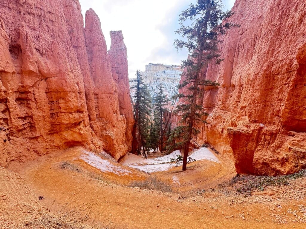
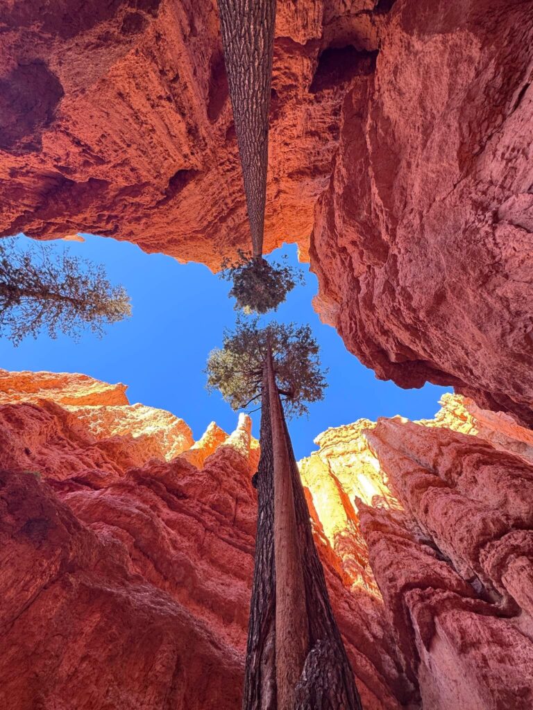
Wall Street is the descent. It starts at Sunset Point and drops you into the canyon via a series of steep, tight switchbacks cut between vertical rock walls. The walls rise 50 to 100 feet on either side in sections. The light comes in narrow. It feels less like a trail and more like a passageway someone forgot to put a roof on.
Two massive ponderosa pines grow directly out of the canyon floor here, surviving in a slot where almost nothing else can. They’re old, thick, and somehow unbothered. The contrast between the living wood and the dead red rock surrounding it is one of the more striking frames in the park.
The footing on Wall Street can be slippery after rain or in early morning when moisture collects in the shade. Take it slow on the descent. Trekking poles earn their weight here.
Queens Garden
Queens Garden opens up after Wall Street and delivers the classic Bryce Canyon hoodoo experience. You’re on the canyon floor, surrounded on all sides by spire formations in layered reds, oranges, and whites. The namesake “Queen” hoodoo sits on a ridge above the trail, a squat formation with a crown-like cap that takes a minute to find and then seems obvious once you do.
This section of trail is more open and less physically demanding than Wall Street or Peekaboo. It’s where you slow down and shoot. The early morning light comes in from the east and moves across the formations as you walk west, which means the photography opportunities shift constantly. Don’t rush it.
Peekaboo Loop
Peekaboo Loop is the longest and most varied section of the combination. It adds significant mileage and the most sustained elevation work of the three. The trail winds through open amphitheater terrain, past formations called The Cathedral and the Wall of Windows, and through several short tunnel-like passages in the rock.
The views from the upper sections of Peekaboo are expansive, with sight lines across the full spread of the canyon and the surrounding plateau. This is where you understand the scale of Bryce. What looks like a contained park from the rim overlooks is a massive system of eroded canyon terrain that goes deep and wide.
Horses use the Peekaboo Loop. Trail traffic flows in both directions. Give horses the right of way, step to the inside of the trail, and stay calm. It’s a well-managed system but worth knowing before you encounter a string of trail rides.
Trail Difficulty and Length
The Wall Street, Queens Garden, and Peekaboo Loop combination runs 6.3 miles with 1,499 feet of elevation gain. Rated moderate to strenuous, which is accurate. The Wall Street descent is steep. Peekaboo Loop accumulates gain across multiple climbs. The elevation at the rim is around 8,000 feet, which affects breathing and energy output, especially for visitors coming from lower elevations.
Plan for four to six hours. This is not a two-hour hike. Bring enough food, water, and sun protection to stay comfortable for a full morning or afternoon. The trail delivers throughout and rewards the pace that lets you actually see it.
Trekking poles make a real difference on Wall Street and the steeper Peekaboo sections. The sandy clay trail surface can be slick when wet.
Dog Friendly?
No. Dogs are not permitted on any of these trails. Bryce Canyon restricts pets to paved surfaces and the Rim Trail between Sunrise and Sunset Points. Leashed and six feet maximum.
Leave your dog at camp or in a climate-controlled vehicle. The canyon is not a safe environment for dogs, between the heat, the narrow trails, and horse traffic on Peekaboo, and the park rules leave no room for interpretation.
What to Bring
Water first. Carry at least three liters per person for this distance. The canyon gets hot fast once the sun clears the rim and there’s no water available on trail. Running dry at the far end of the Peekaboo Loop is not a fun situation.
Food for the full duration. High-calorie snacks that don’t need refrigeration. A real lunch if you’re doing the long version of the loop.
Sun protection is non-negotiable at 8,000 feet. Hat, sunscreen, UV-blocking layers. The canyon walls provide shade in sections but you’re exposed on much of the Peekaboo terrain.
Trekking poles for Wall Street and the descent sections. A light layering piece for early morning starts in spring and fall. Good trail runners or hikers with traction, not sandals.

Best Time to Hike Wall Street, Queens Garden, and Peekaboo Loop
May through June and September through October are the best windows. Temperatures are comfortable, the light is cooperative, and the crowds, while present, are manageable if you start early.
Summer hiking is possible but requires discipline. On trail by 6:30 or 7 a.m. to complete the canyon section before midday heat builds. The canyon floor amplifies heat once the sun hits it directly. Afternoon thunderstorms in July and August can develop fast. Watch the sky on Peekaboo, where you’re more exposed.
For photography, the first two hours after sunrise are the prime window. The light hits the eastern faces of the hoodoos in Queens Garden and Wall Street at a low angle that maximizes texture and depth. The colors shift from pale pink to deep orange as the light rises. Peekaboo’s upper sections catch good late-afternoon light if you’re on a longer schedule.
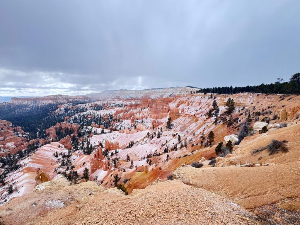
Winter hiking is possible with microspikes or traction devices. Wall Street can ice up in the shaded sections. Snow on the hoodoos creates some of the most striking imagery in the park, but know what you’re committing to before you drop off the rim.
Rules and Regulations
A valid entrance pass is required. The per-vehicle fee is $35 for seven days. The America the Beautiful Annual Pass covers this and every other national park.
Stay on designated trails. The formations in Bryce are fragile calcium carbonate and erode quickly when disturbed. Off-trail movement damages hoodoos and destabilizes the canyon floor.
Pack out everything. Leave No Trace. No drones. No fires outside designated areas. No feeding wildlife.
On Peekaboo Loop, yield to horses. Step to the inside (canyon wall side) of the trail, remain calm, and wait for the group to pass. It’s standard trail etiquette and keeps everyone safe.
Where to Stay Near Bryce Canyon
Bryce Canyon City just outside the park entrance has several lodging options within minutes of the trailhead. Panguitch to the north and Kanab to the south offer wider selection about an hour out.
Marriott Bonvoy members should search properties in Cedar City, about an hour northwest, for the most reliable chain hotel options near the park.
IHG Rewards travelers can check IHG properties near Cedar City or Panguitch for points options in the region.
Hilton Honors members should search Hilton properties in St. George, about two hours southwest. Natural pairing with a Zion leg on the same trip.
The Lodge at Bryce Canyon inside the park is the most convenient base for an early start and books out months ahead for summer. If you want to wake up 10 minutes from the trailhead, plan early.
Camping Nearby
North Campground and Sunset Campground are both inside Bryce Canyon National Park. North Campground is open year-round and sits near the visitor center. Sunset Campground is closer to the Sunset Point trailhead. Both fill fast in summer. Book on Recreation.gov as early as reservations open.
For more flexibility, the Dixie National Forest borders the park on multiple sides and allows dispersed camping outside designated campground zones. Red Canyon Campground, about 10 miles west in Dixie National Forest near Panguitch, is a solid developed option with less reservation competition than the in-park campgrounds.
Nearby Adventures
If you want more Bryce Canyon terrain, the Tower Bridge Trail (3.6 miles, 839 feet of gain) is the best standalone hike in the park for a quieter experience. It starts from Sunrise Point and takes you to a natural double-arch formation that most visitors never see.
At the park’s southern end, Rainbow Point, Yovimpa Point, and the Bristlecone Loop (1.3 miles, 118 feet of gain) deliver panoramic views of the Grand Staircase and ancient bristlecone pines. A completely different experience from the canyon floor.
The Arches Trail in Red Canyon (0.6 miles, 187 feet of gain) is 10 miles west of the park entrance in Dixie National Forest. Natural limestone arches in a quieter setting, dog-friendly, and a natural add-on at the start or end of a Bryce trip.
Bryce Canyon’s night skies are among the darkest in the lower 48. The park runs ranger-led astronomy programs through summer. If you’re spending a night in the area, build your schedule around one.
Plan This Hike
Get turn-by-turn directions, trail conditions, user reviews, and offline map downloads for Wall Street, Queens Garden, and Peekaboo Loop on AllTrails: View on Alltrails.
AllTrails is the tool I use for every hike. The offline map download is essential for anywhere with uncertain cell service, and Bryce Canyon’s canyon floor qualifies. The review feed gives you condition reports from the last week, useful for checking ice on Wall Street in early spring or post-storm mud on Peekaboo.
Chase the Quiet
I’ve hiked Wall Street in snow and in September heat and at the edge of a thunderstorm that rolled in over Peekaboo faster than I’d have liked. Every time, the canyon does the same thing. It takes whatever you brought in and makes it smaller. The scale of the formations, the color, the way the light moves through the slot, it puts things in proportion. That’s what I keep coming back for.
Support the Adventure
To make your walls less boring, check out my photography portfolio and bring a piece of the wild and my story into your home.
If you’d like to fuel future adventures, you can donate a coffee on Ko-Fi. Every cup keeps me chasing sunrises and stories.
When you shop using my affiliate links, every click helps support this blog at no extra cost to you. It’s a small way to keep Unicorn Adventure alive and kicking while I keep exploring.
Subscribe to my mailing list for future updates, new stories, and behind-the-scenes adventures.
Stay connected with me on Instagram and Facebook for more photos and daily inspiration.
Thanks for being part of the journey, Unicorn Squadron!

Theo Maynard is a landscape photographer and adventure blogger based in Salt Lake City. He chases remote desert and mountain light across the American West, documents it all solo, and shares the journey through Unicorn Adventure. He’s on the autism spectrum, and that’s not a footnote, it’s the whole story. He creates to inspire others to get outside, chase what lights them up, and live their best possible life. Unapologetically himself.