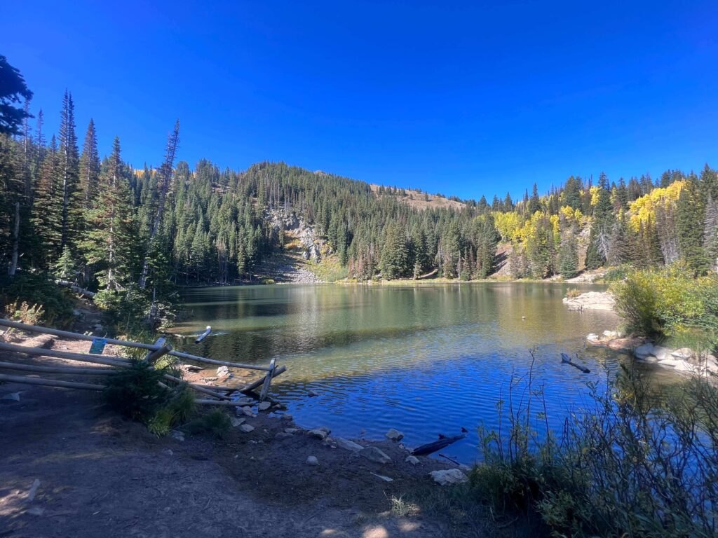
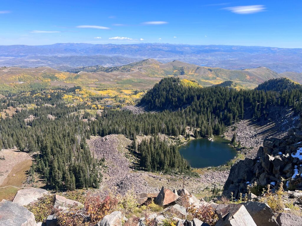
Clayton Peak is a Wasatch summit above Guardsman Pass in the Bonanza Flat Conservation Area near Park City. The route via Bloods Lake Trail is 5.5 miles roundtrip with 1,600 feet of gain, approaching the summit by way of Bloods Lake, an alpine lake that serves as both a natural rest point and the visual preview of the high country above it. From the summit, on clear days the view reaches the Great Salt Lake to the northwest, the Uintas to the east, and the full sweep of the Wasatch Range in both directions.
The Bloods Lake approach serves multiple objectives from the same starting point. The area is managed as a conservation area by Salt Lake County, not the Forest Service, which affects some regulations. Check current Bonanza Flat access rules before your visit.
Quick Facts
|
Trail Name |
Clayton Peak via Bloods Lake Trail |
|
Location |
Bonanza Flat Conservation Area, near Park City, Utah |
|
Coordinates |
40.6100 N, 111.5361 W (Bloods Lake Trailhead at Guardsman Pass) |
|
Distance |
~5.5 miles roundtrip |
|
Elevation Gain |
~1,600 feet |
|
Difficulty |
Hard |
|
Time |
3-5 hours |
|
Dogs Allowed |
Yes, on leash; check current Bonanza Flat regulations |
|
Fee |
Free |
How to Get There
From Park City, take UT-224 south from downtown. Follow the road as it climbs toward Guardsman Pass. The Bloods Lake Trailhead is at the top of Guardsman Pass, on the right side of the road. The drive from downtown Park City takes about 20-30 minutes.
From Salt Lake City, Guardsman Pass is accessible from the Big Cottonwood Canyon side via UT-190 east to Guardsman Pass Road. Check current road conditions; Guardsman Pass Road closes in winter and the exact reopening date varies by year. Confirm current access on both the Park City side (UT-224) and the Salt Lake side before planning your trip.
From Salt Lake City’s west side, the Big Cottonwood Canyon approach is about 40-45 minutes. From downtown Park City, 20-30 minutes. From Provo or Orem, plan about 1 hour via I-15 north to Park City.
Parking Information
The Bloods Lake Trailhead at Guardsman Pass has an unpaved parking area that accommodates a good number of vehicles. No fees either. The lot fills on summer and fall weekends; arrive before 8 a.m. on peak days. Guardsman Pass Road is closed in winter, so the lot is not accessible for winter hiking unless you’re approaching from a lower elevation on foot.
Cell Service and Navigation
Cell coverage decreases on the approach to Guardsman Pass and is limited or absent at the trailhead and on the trail. Download AllTrails offline before leaving Park City or Salt Lake City. The route is well-marked from the trailhead through Bloods Lake; the upper climb to Clayton Peak requires more attention to the route on the rocky ridge section. GPS active on the upper section is useful for confirming your position on the ridge and identifying the summit.
What to Expect on the Clayton Peak Route
Bloods Lake
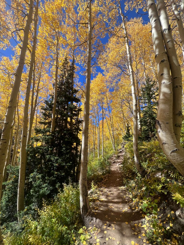
The trail from the Guardsman Pass trailhead climbs through aspen and pine forest for the first mile before arriving at Bloods Lake. The lake sits in an open basin surrounded by the higher ridgeline, and it’s a natural stopping and photography point before continuing to the summit. The lake reflects the sky and the surrounding peaks in calm morning conditions.
Many hikers turn around at Bloods Lake, which makes the Lackawaxen Lake Trail variation another option from the same starting point for a less committing day. From Bloods Lake, the trail continues upward and the terrain opens as the summit ridge comes into view.
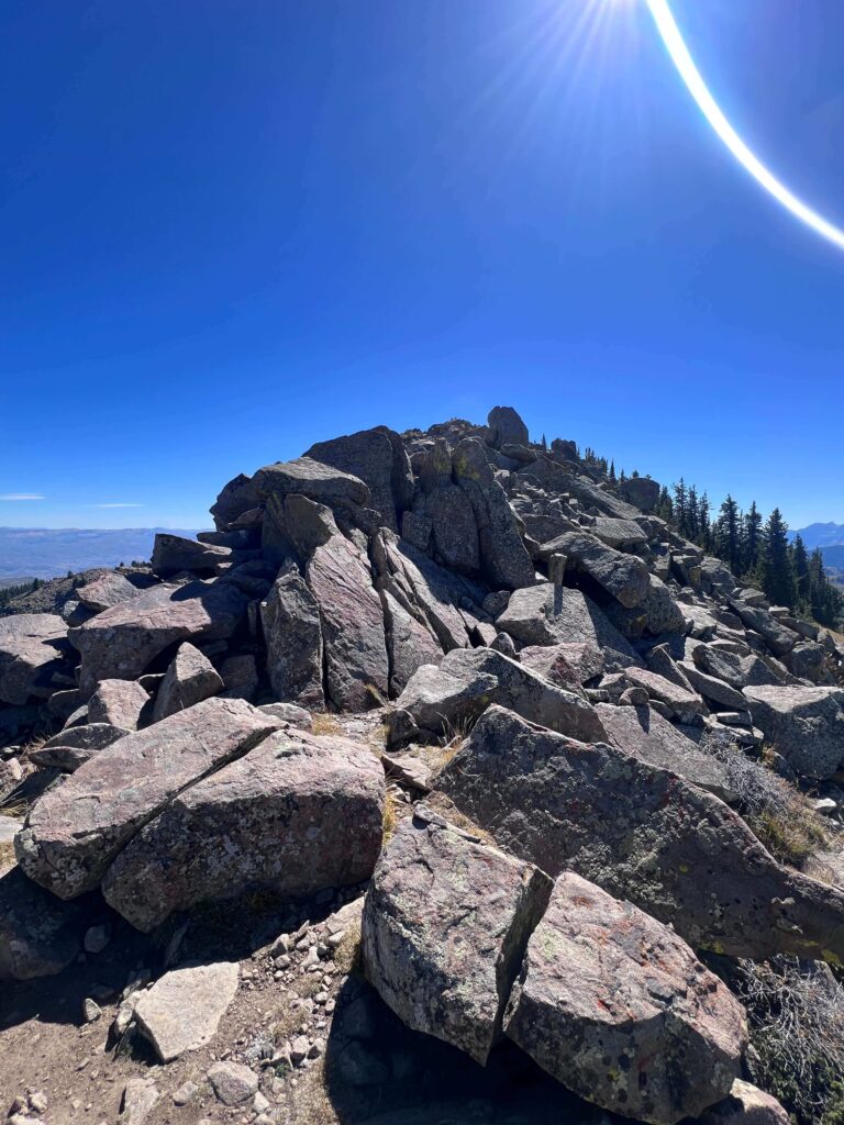
The Ridge and Summit
Past Bloods Lake, the trail steepens and the terrain becomes rocky as you gain the ridge toward Clayton Peak. The final approach to the summit is the crux: steep, rocky, with some exposure on the ridge edge. This section is what earns the hard rating; the lower trail through Bloods Lake is moderate in character.
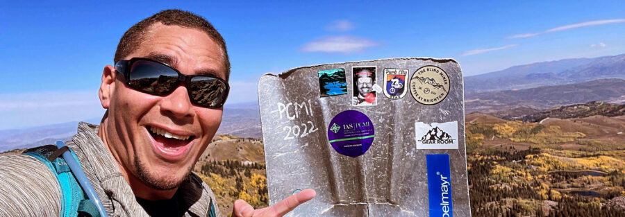
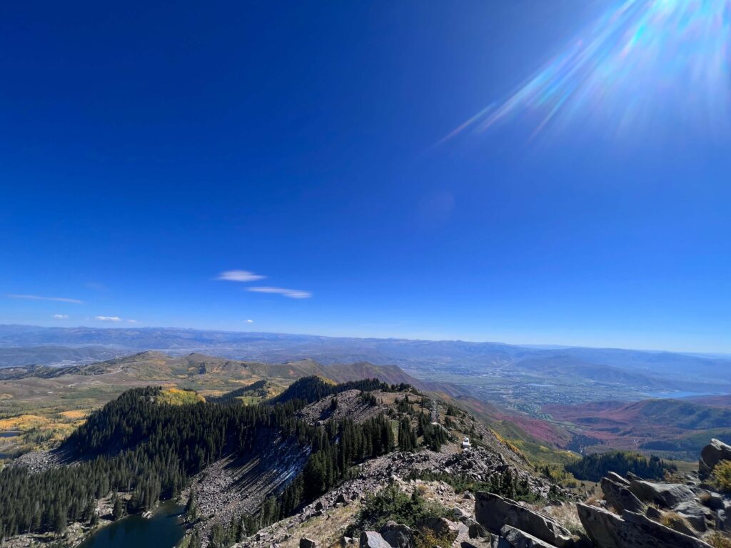
The Clayton Peak summit delivers the 360-degree view the approach earns. The Great Salt Lake is visible to the northwest on clear days, the Uintas extend to the east, Park City’s ski resort infrastructure is visible below in the valleys immediately below, and the Wasatch Range ridge runs in both directions at roughly eye level. On a clear October morning, the horizontal visibility from this summit is exceptional.
For photography: the summit’s position above Park City and the valleys between the Wasatch and the Salt Lake Basin creates a distinctive east-west panorama. Morning light from the east illuminates the Uintas and the upper ridge. Afternoon light falls on the Great Salt Lake and the valley below to the west. Fall color in the aspen groves below the summit visible from the top makes September and October the photography priority window.
Trail Difficulty and Length
Clayton Peak via Bloods Lake Trail is 5.5 miles with 1,600 feet of gain. Hard is the accurate rating. 1,600 feet of gain with a steep rocky ridge summit approach is Hard by standard Wasatch Front trail rating conventions. Budget 3-5 hours for the roundtrip at a comfortable pace with time at the lake and the summit.
Dog Friendly?
Yes with a caveat: the Bonanza Flat Conservation Area is managed by Salt Lake County rather than the USFS, and its specific dog and leash policies should be confirmed before your visit at the Bonanza Flat conservation area website or signage at the trailhead. Bloods Lake provides water access. Bring additional water for the upper rocky ridge section where no trail water is available.
What to Bring
Water: 3 liters for a hard 5.5-mile day. The high alpine terrain and exposure on the ridge dehydrates faster than equivalent effort at lower elevation. Layers for the summit ridge where wind is present in most conditions. Sturdy hiking boots with ankle support for the rocky upper ridge. Sun protection for the exposed summit sections.
Best Time to Hike Clayton Peak
July through October is the reliable window. The Guardsman Pass Road typically opens by June but snow can persist on the upper ridge sections into early July. Check current conditions before any visit before mid-July.
September and October are the best months. The aspen groves below the summit are in full color by late September. The summit view in fall with the aspen color in the valleys below is the premium photography visit. Crowds are significantly reduced compared to summer. Temperatures are ideal for a hard 5.5-mile climb.
Afternoon thunderstorms develop over the Wasatch in July and August. The exposed summit and ridge are serious lightning zones. Start by 7 a.m. and plan to be off the summit by noon on storm-likely summer days.
Rules and Regulations
Bonanza Flat Conservation Area rules apply. Check current regulations at the Bonanza Flat land management website or trailhead signage before visiting; as a county-managed conservation area its specific rules may differ from USFS land. Standard Leave No Trace principles throughout. Dogs on leash; confirm current dog policy. Pack out all trash.
Where to Stay Near Park City
Park City is the obvious base with full resort town infrastructure. For points travelers, check available Marriott Bonvoy properties in Park City, IHG Rewards hotels in Park City, and Hilton Honors options in Park City. Summer and fall weekends in Park City book fast; plan ahead. Salt Lake City, 30-40 minutes via I-80, is the large metro base.
Camping Nearby
Big Cottonwood Canyon has developed campgrounds on the approach from the Salt Lake side. No camping is permitted in the Bonanza Flat Conservation Area itself. Mill Creek Canyon area and the Cottonwood Canyons have dispersed camping options on USFS land.
Nearby Adventures
The Lackawaxen Lake Trail via Bloods Lake is another option from the same Bonanza Flat trailhead: a more moderate option that takes the Bloods Lake approach to Lackawaxen Lake rather than continuing to the Clayton Peak summit. A natural option for a less-committing day from the same parking area.
The Wasatch Crest Trail is accessible from the Guardsman Pass area and runs along the ridgeline through some of the best high-country terrain in the Wasatch. Worth knowing about for anyone who wants to extend the day or explore the ridgeline beyond Clayton Peak.
Park City’s mountain biking network is the summer alternative for days when hiking isn’t the plan. The resort infrastructure offers lift-accessed trails and the town has a full range of food and dining options for post-hike.
Plan This Hike
AllTrails has Clayton Peak via Bloods Lake Trail mapped with offline GPS tracking and condition reports including current road status and upper ridge snow. Download before leaving Park City. Plan your hike on AllTrails and pull the offline map while you’ve got signal in town.
Chase the Quiet
The Guardsman Pass area sits at the boundary between Park City and the Salt Lake Valley, above both of them at the top of the divide. From Clayton Peak’s summit you can see the resort infrastructure in the valleys below and the Great Salt Lake Basin beyond it simultaneously. That particular view, with the full geographic relationship between the mountains, the urban areas, and the desert basin visible at once, is something you can’t get from inside any of those environments. Summit-level views change how you read the landscape you live in. That’s worth the climb.
Support the Adventure
To make your walls less boring, check out my photography portfolio and bring a piece of the wild and my story into your home.
If you’d like to fuel future adventures, you can donate a coffee on Ko-Fi. Every cup keeps me chasing sunrises and stories.
When you shop using my affiliate links, every click helps support this blog at no extra cost to you. It’s a small way to keep Unicorn Adventure alive and kicking while I keep exploring.
Subscribe to my mailing list for future updates, new stories, and behind-the-scenes adventures.
Stay connected with me on Instagram and Facebook for more photos and daily inspiration.
Thanks for being part of the journey, Unicorn Squadron!

Theo Maynard is a landscape photographer and adventure blogger based in Salt Lake City. He chases remote desert and mountain light across the American West, documents it all solo, and shares the journey through Unicorn Adventure. He’s on the autism spectrum, and that’s not a footnote, it’s the whole story. He creates to inspire others to get outside, chase what lights them up, and live their best possible life. Unapologetically himself.