Goosenecks Viewpoint and Sunset Point are two adjacent short trails in Capitol Reef National Park that deliver the park’s characteristic canyon geology, Sulphur Creek winding through deep red canyon walls and the Waterpocket Fold’s nearly 100-mile geological wrinkle, without requiring a long or technical hike.
Capitol Reef is one of Utah’s five major national parks and the least visited of the five. The park’s position on UT-24 between Moab and Bryce Canyon makes it a natural road trip stop, and the Goosenecks / Sunset Point overlooks are the park’s most accessible views for visitors passing through on a limited schedule.
Quick Facts
|
Trail Name |
Goosenecks Viewpoint Trail and Sunset Point Trail |
|
Location |
Capitol Reef National Park, near Torrey, Utah |
|
Coordinates |
|
|
Distance |
~2.5 miles combined roundtrip |
|
Elevation Gain |
~300 feet combined |
|
Difficulty |
Easy |
|
Time |
1-2 hours for both trails |
|
Dogs Allowed |
No (dogs not permitted on most Capitol Reef trails) |
|
Fee |
$20 per vehicle (7-day pass); America the Beautiful Pass accepted |
|
AllTrails |
How to Get There
Capitol Reef National Park is on Utah UT-24, approximately 11 miles east of Torrey, Utah. The Goosenecks and Sunset Point trailhead parking area is accessible from the main park road with clear signage.
From Salt Lake City: I-15 south to US-50 east to UT-24 east into the park. Plan about 3.5 hours. From Moab: US-191 north to UT-24 west. Plan about 2.5 hours. From Bryce Canyon: UT-12 east to Torrey, then UT-24 east. Plan about 1.5-2 hours. From Las Vegas: I-15 north to UT-20 east to US-89 north to UT-12 east to Torrey. Plan about 5.5-6 hours.
Parking Information
Shared parking lot near the Goosenecks and Sunset Point trailheads. Generally adequate capacity. During peak spring and fall seasons, the lot fills during morning golden hour and at sunset; arrive early for those windows. The $20 vehicle entry fee covers the full 7-day pass and is paid at the park entrance on UT-24. America the Beautiful Annual Pass covers Capitol Reef entry.
Cell Service and Navigation
Cell coverage is limited or absent in Capitol Reef National Park. Download AllTrails offline before leaving Torrey. The trailheads are well-signed from the main park road; navigation to the parking area is straightforward. Having the GPS coordinates loaded before entry is useful for confirming the correct lot.
What to Expect at Goosenecks and Sunset Point
Goosenecks Viewpoint
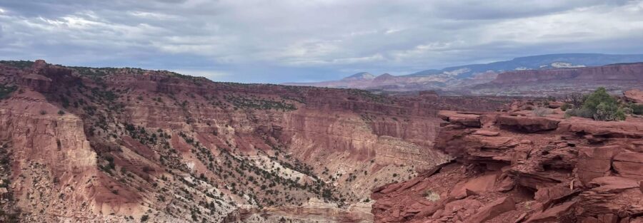
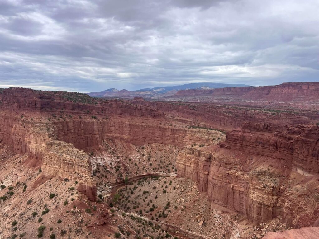
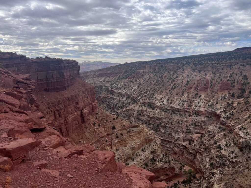
The Goosenecks Viewpoint overlooks Sulphur Creek as it carves through the canyon below in a series of tight meanders, the ‘gooseneck’ shape that the name describes. The creek’s winding path through the deep red canyon walls is visible from the rim, showing hundreds of feet of canyon cut in a compact visual frame. The Waterpocket Fold’s characteristic red and white layered sandstone walls surround the canyon view on all sides.
Sunset Point
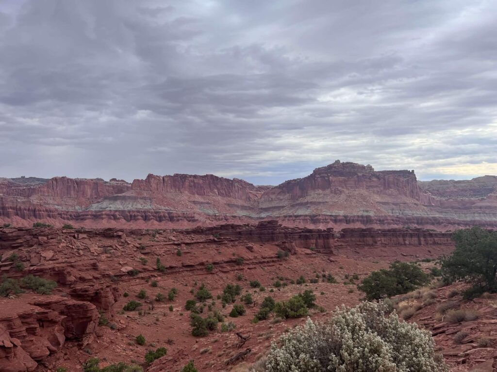
Sunset Point provides a broader panoramic view of the Waterpocket Fold, the almost 100-mile geological wrinkle that defines Capitol Reef’s landscape. The Fold is the result of a monocline, a tilted section of the earth’s crust, that exposed rock layers dating back hundreds of millions of years in a nearly continuous cliff face running north to south through the park. Sunset Point gives the most accessible view of that full geological structure.
As the name suggests, late afternoon is the priority timing: the sun sets to the west and illuminates the Waterpocket Fold’s layered cliffs from the front, turning the rock from warm orange to deep red to purple as the light drops. This is one of the better accessible sunset viewpoints in Utah’s canyon country.
For photography: Goosenecks in early morning when the canyon is partially lit and partially shadowed creates interesting depth. Sunset Point from 30-60 minutes before actual sunset for the full color progression on the Waterpocket Fold. Wide-angle for the canyon context and the fold panorama, mid-range for the rock layer detail. Capitol Reef is a designated International Dark Sky Park; if you’re staying the night in Torrey, the post-sunset sky above Sunset Point earns its own photography session.
Trail Difficulty and Length
The combined route is approximately 2.5 miles with 300 feet of gain. Easy is accurate for both overlooks individually. Budget 1-2 hours for visiting both viewpoints with time at each overlook.
No Dogs Allowed
Dogs are not permitted on the Goosenecks or Sunset Point trails. This is standard policy throughout most Capitol Reef trail corridors. Pets may be in park campgrounds and on paved surfaces but not on unpaved trails. Plan dog logistics before the Capitol Reef visit.
What to Bring
Water: 1.5-2 liters for a short easy hike in desert conditions. Sun protection for the exposed canyon rim sections. Camera with wide-angle and mid-range capability. For sunset photography: a tripod and extra battery given the low-light conditions at the end of the golden hour. Layers for the evening visit; Capitol Reef at elevation (Torrey is about 6,800 feet) cools quickly after sunset.
Best Time to Hike
Sunrise for Goosenecks: the east-facing canyon catches early morning light before the canyon walls go fully overhead-lit. Sunset for Sunset Point: the entire point is named for the timing. Both viewpoints are worth visiting in the same trip by staggering your timing: Goosenecks in the morning, other park trails midday, Sunset Point in the hour before sunset.
Spring (April through June) and fall (September through October) are the most comfortable temperature windows. Summer is possible with morning starts; Capitol Reef’s elevation moderates the summer heat compared to lower-elevation Utah desert parks, but July and August midday still exceeds 90°F. Winter visits offer solitude and the possibility of snow on the canyon walls, which creates a different and distinctive visual on the red rock.
Rules and Regulations
Stay on designated trails. No dogs on unpaved trails. Leave No Trace principles throughout. No collecting rocks, plants, or artifacts. Capitol Reef is an International Dark Sky Park; minimize artificial light at night. $20 vehicle entry fee or America the Beautiful Pass.
Where to Stay Near Capitol Reef
Torrey, Utah, about 11 miles west of the park, is the primary gateway with lodging, dining, and services. Capitol Reef has the Fruita Campground inside the park. Moab is about 2.5 hours east with full resort town lodging infrastructure. For points travelers, check available Marriott Bonvoy properties, IHG Rewards hotels, and Hilton Honors options in Salt Lake City, Moab, or Cedar City along your route.
Camping Nearby
Fruita Campground inside Capitol Reef on the park road has developed sites; first-come first-served for most sites with some reservable through recreation.gov. The surrounding BLM land outside the park has dispersed camping. Goblin Valley State Park (about 45 minutes south on UT-24) has developed camping and is a natural addition to a Capitol Reef multi-day trip.
Nearby Adventures
Capitol Reef has a substantial trail catalog beyond Goosenecks and Sunset Point: Grand Wash Trail via Northeast Trailhead, Chimney Rock Loop Trail, Cassidy Arch Trail, Hickman Bridge Trail, Cohan Canyon Trail (3.0 miles / 793 ft), Capitol Gorge to Tanks Trail (2.2 miles / 396 ft), Rim Overlook Trail (4.1 miles / 1,053 ft), and Fremont River (2.1 miles / 410 ft). The Goosenecks and Sunset Point viewpoints are the accessible entry point into trails that extend to hard summit hikes and technical canyon routes.
The Fruita Historic District within the park, 19th-century Mormon settlement, orchards you can pick from in season, the Gifford Homestead for pies, adds a cultural history dimension to the park visit. Worth scheduling time for on any Capitol Reef trip. Bryce Canyon and Moab are the natural before-and-after stops on a southern Utah road trip.
Plan This Hike
AllTrails has the Goosenecks Viewpoint and Sunset Point trails mapped with offline capability. Download before entering the park. Plan your visit on AllTrails and pull the offline map while you’ve got signal in Torrey.
Chase the Quiet
Capitol Reef is the least visited of Utah’s five major national parks by a significant margin. Zion and Bryce Canyon get ten to fifteen times the annual visitors. The Goosenecks and Sunset Point trails get a fraction of that. The Waterpocket Fold is nearly 100 miles long and visible from an overlook that most people drive past on UT-24 on the way between Moab and Bryce without stopping. The canyon that Sulphur Creek carved through the fold is visible from a rim trail that takes less than an hour. That’s the deal Capitol Reef offers: one of the most distinctive geological features on the Colorado Plateau, accessible in an afternoon, with crowds at a fraction of what the other four parks deliver. Take the detour.
Support the Adventure
To make your walls less boring, check out my photography portfolio and bring a piece of the wild and my story into your home.
If you’d like to fuel future adventures, you can donate a coffee on Ko-Fi. Every cup keeps me chasing sunrises and stories.
When you shop using my affiliate links, every click helps support this blog at no extra cost to you. It’s a small way to keep Unicorn Adventure alive and kicking while I keep exploring.
Subscribe to my mailing list for future updates, new stories, and behind-the-scenes adventures.
Stay connected with me on Instagram and Facebook for more photos and daily inspiration.
Thanks for being part of the journey, Unicorn Squadron!

Theo Maynard is a landscape photographer and adventure blogger based in Salt Lake City. He chases remote desert and mountain light across the American West, documents it all solo, and shares the journey through Unicorn Adventure. He’s on the autism spectrum, and that’s not a footnote, it’s the whole story. He creates to inspire others to get outside, chase what lights them up, and live their best possible life. Unapologetically himself.