

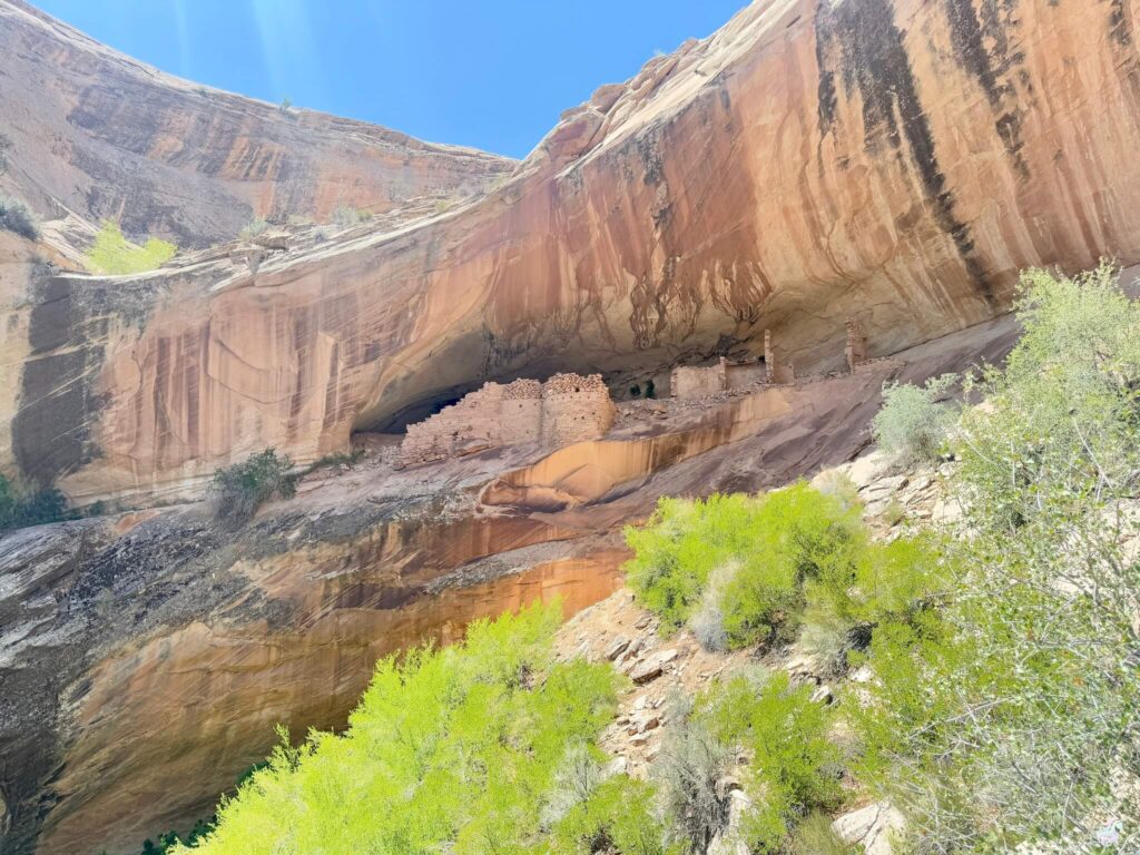
The Ancestral Puebloans left fingerprints everywhere in this landscape. At Monarch Cave, those fingerprints are literal, carved into stone walls. Petroglyphs. Granaries. A whole alcove dwelling tucked into Comb Ridge like a secret. The hike is short and easy, but what you find at the end rewires how you see the people who lived here before. For me, hiking to places like this is about more than getting the shot or checking a box. It’s about standing in the space where different ways of living happened, understanding that someone else came to the quiet places first, and respecting what they left behind. Solo, I get to sit with that without rush.
Quick Facts
Trail Name | Monarch Cave via Comb Ridge |
Location | Bears Ears National Monument, Bluff, Utah |
Coordinates | |
Distance | 1.6 miles |
Elevation Gain | 127 ft |
Difficulty | Easy |
Time Required | 1.5 to 2 hours |
Dogs Allowed | No |
Fee | $5 day pass, $10 week pass |
AllTrails |
How to Get There
Monarch Cave is about 10 miles west of Bluff, Utah. From Bluff, take UT-163 west for about three miles, then turn right onto Butler Wash Road. This is an unpaved road, generally passable for most vehicles, but it can get rough after rain. Check conditions before you go. Drive approximately seven miles north on Butler Wash Road until you see a small, unmarked parking area on the left. There’s no official trailhead sign, so use GPS coordinates or a reliable map to make sure you’re in the right spot. The trail begins on the opposite side of the road and heads west toward Comb Ridge.
Parking Information
Parking is limited, a small dirt pullout with space for a handful of vehicles. There’s a $5 one-day pass or $10 week pass required to access the Cedar Mesa and Comb Ridge area. Pay at the trailhead box or online before you go. No restrooms, no trash cans, no amenities. Pack out everything you pack in. The area is remote, so let someone know your plans before heading out.
Cell Service and Navigation
Cell service is spotty or nonexistent out here. Download offline maps before you go. Have GPS coordinates loaded into your phone or device. The trailhead is unmarked, so this matters. GPS works fine for navigation on the trail itself. Let someone know where you’re headed and when you expect to return. This is remote country.
What to Expect on Monarch Cave Trail
The Canyon Walk
The trail winds through a desert canyon framed by the towering cliffs of Comb Ridge. You’ll walk sandy washes, cross sections of slickrock, and scramble over some rocky terrain. Not technical, just real ground. Watch the canyon walls. Juniper, piñon pine, prickly pear cactus scattered along the route. The rock changes color as the sun moves. Red, orange, tan. Nothing too steep, but sandy terrain gets tiring in heat, so bring water and take your time.
The Petroglyphs and Ruins
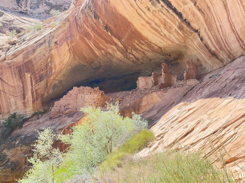
As you hike, you’ll spot petroglyphs carved into the canyon walls. Ancient handprints. Geometric patterns. Figures that mean things we’re still trying to understand. Keep your eyes open. At the end of the trail, the canyon opens to reveal Monarch Cave, a large alcove tucked into the cliffside. Inside, you’ll find well-preserved ruins, granaries, walls, rock art. The structures are remarkably intact. It’s a vivid sense of how the Ancestral Puebloans lived here, built here, thrived here.
The Responsibility
This isn’t just another hike. This is cultural heritage. These ruins are thousands of years old. They’re fragile. Don’t touch the structures. Don’t remove pottery or artifacts. Don’t climb on anything. Stay on the trail. Treat the place with respect. The rock carvings, the granaries, the walls, the silence, it’s all part of a story that doesn’t belong to us. We’re visitors here.
Trail Difficulty and Length
1.6 miles round trip, rated easy. Mostly flat for the walk in, with sandy sections and some rocky scrambling. The final approach to the cave involves climbing a slickrock slope, so wear sturdy shoes with good grip. Sandy terrain is tiring in heat, especially at high sun. Bring plenty of water. Move at a reasonable pace. This isn’t a race.
Dog Friendly?
No. Dogs are not allowed at the Monarch Cave site, even leashed. Pets are prohibited in alcoves, ruins, and rock art areas. This is a cultural protection measure and it’s not negotiable. If you want to hike this trail, leave your dog at home or make other arrangements. The rules exist for good reason.
What to Bring
Water. Lots of it. No shade on this trail, and sandy terrain drains you fast. Sturdy hiking boots with good traction for slickrock and sand. Sunscreen. Hat. Layers, because shade in the canyon is cold, sun is hot. A camera if you’re documenting the petroglyphs, but remember to respect the site while shooting. Binoculars for spotting details in the rock art. Leave the drone at home, it’s not welcome here. Bring a pack to carry out any trash you find. The site deserves to stay clean.
Best Time to Hike Monarch Cave Trail
Spring and fall are ideal. March through May and September through early November offer mild temps, clear skies, and that soft light that makes petroglyphs come alive. Summer is brutal. Temps exceed 90, often hitting triple digits. If you go in summer, start at sunrise and be done before midday. Winter can be chilly, mornings especially, and the canyon gets icy in spots. Bring layers. Sunrise and sunset are magical here, the light catching the petroglyphs and the ruins in ways that remind you these people weren’t abstract history, they were real.
Rules and Regulations
This site is on BLM land and is protected as an archaeological site. The rules are firm. Stay on the established trail. Do not touch or climb on the ruins. They’re extremely fragile. Don’t touch petroglyphs. Don’t remove any artifacts or pottery shards. Leave everything where you find it. Don’t camp at the cave. No fires. Keep noise low. Respect the cultural significance of what you’re standing inside. These protections exist because the site matters.
Where to Stay Near Bluff
Base yourself in Bluff, a quirky small town about 10 miles east. Bluff has personality, good food, local art galleries, and a real frontier feel. It’s a base that matters as much as the hike itself. Take time to explore the town. For points travelers, check available Marriott Bonvoy properties, IHG Rewards hotels, and Hilton Honors options in the broader Four Corners area.
Camping Nearby
No camping is allowed at Monarch Cave itself. Muley Point, a few miles away, offers dispersed camping with unreal views. Recapture Reservoir northeast of Bluff has established camping with water and facilities. BLM land around Cedar Mesa has multiple dispersed spots, though water is scarce. Check current regulations before you camp, as closures and fire restrictions change seasonally.
Nearby Adventures
Butler Wash Interpretive Trail is nearby and offers easy access to other Ancestral Puebloan sites. The Under the Natural Bridges Loop is a longer hike through White Canyon past three distinct natural bridges, Sipapu, Kachina, and Owachomo. Goosenecks State Park offers dramatic river views south of here. For history, visit Bluff Fort Historic Site in Bluff, a restored pioneer settlement. Twin Rocks Trading Post has authentic Navajo jewelry, pottery, and rugs. Monument Valley is about an hour south if you want to explore that landscape too.
Plan This Hike
AllTrails has the route and community reviews, though this trail gets less traffic than bigger hikes. Download offline maps and load the GPS coordinates before you head out. This trailhead is unmarked, so preparation matters. Use the link below to check it out: View on AllTrails.
Chase the Quiet
Standing inside Monarch Cave, you’re not just looking at ancient structures. You’re inside someone else’s story. Someone built these granaries. Someone carved those petroglyphs. Someone lived in this alcove and looked out at the same canyon. The rocks are still there. The canyon is still there. And you’re standing in it, quiet, trying to understand what that connection means.
Support the Adventure
To make your walls less boring, check out my photography portfolio and bring a piece of the wild and my story into your home.
If you’d like to fuel future adventures, you can donate a coffee on Ko-Fi. Every cup keeps me chasing sunrises and stories.
When you shop using my affiliate links, every click helps support this blog at no extra cost to you. It’s a small way to keep Unicorn Adventure alive and kicking while I keep exploring.
Subscribe to my mailing list for future updates, new stories, and behind-the-scenes adventures.
Stay connected with me on Instagram and Facebook for more photos and daily inspiration.
Thanks for being part of the journey, Unicorn Squadron!
Tags: Monarch Cave, Comb Ridge, Bears Ears National Monument, Ancestral Puebloan, petroglyphs, Utah hiking, archaeological sites, cultural heritage, easy hike, Bluff Utah, desert canyon, rock art, adventure travel
Theo Maynard is a landscape photographer and adventure blogger based in Salt Lake City. He chases remote desert and mountain light across the American West, documents it all solo, and shares the journey through Unicorn Adventure. He’s on the autism spectrum, and that’s not a footnote, it’s the whole story. He creates to inspire others to get outside, chase what lights them up, and live their best possible life. Unapologetically himself.
Theo Maynard is a landscape photographer and adventure blogger based in Salt Lake City. He chases remote desert and mountain light across the American West, documents it all solo, and shares the journey through Unicorn Adventure. He’s on the autism spectrum, and that’s not a footnote, it’s the whole story. He creates to inspire others to get outside, chase what lights them up, and live their best possible life. Unapologetically himself.