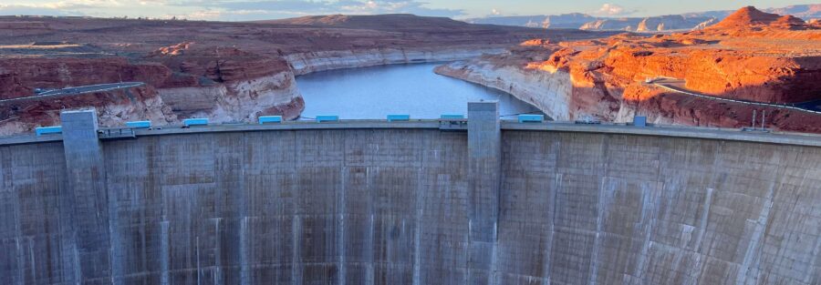
Glen Canyon Bridge spans 1,271 feet across the canyon above Glen Canyon Dam, with the Colorado River 700 feet below. It’s a pedestrian walkway and an active highway bridge, accessible from the Glen Canyon Dam Visitor Center parking area on a 1-mile paved roundtrip. The view from the center of the bridge looks directly at the dam face to the east and down the Colorado River corridor to the west. It’s the most direct access to the dam’s scale from a standing position, and it’s free.
Quick Facts
|
Name |
Glen Canyon Bridge (US-89 Bridge) |
|
Location |
Glen Canyon National Recreation Area, near Page, Arizona |
|
Coordinates |
|
|
Distance |
~1 mile roundtrip (across and back) |
|
Elevation Gain |
Less than 50 feet |
|
Difficulty |
Easy |
|
Time |
20-45 minutes |
|
Dogs Allowed |
Yes, on leash |
|
Fee |
Free; Glen Canyon NRA entry fee ($35/vehicle) may apply depending on access |
|
AllTrails |
How to Get There
From Page, head west on US-89 toward the Glen Canyon Dam. Follow signs to the Glen Canyon Dam Visitor Center parking area. The bridge is visible before you reach the parking area and is directly accessible from the visitor center on foot. The drive from downtown Page takes about 5 minutes.
From Salt Lake City, Page is about 4.5-5 hours south via I-15 and US-89 through Kanab. From Las Vegas, about 4 hours northeast on I-15 and US-89. From Flagstaff, about 2 hours north on US-89. Page is a natural overnight stop on Colorado Plateau road trips between Utah and Arizona.
Parking Information
The Glen Canyon Dam Visitor Center has a spacious free parking lot with restrooms and informational exhibits. It serves both the bridge walk and the dam visitor center tours. During peak spring and fall tourist season the lot fills by mid-morning. Arrive by 8 a.m. on busy days. The bridge itself is a public thoroughfare open at all times; parking availability determines practical access.

What to Expect on the Bridge
The bridge walkway is paved, flat, and wide enough for pedestrians and vehicles to coexist. A dedicated pedestrian lane runs alongside the highway lane. The walkway is fully accessible.
From the center of the bridge, looking east, the Glen Canyon Dam face is directly visible. The dam sits about 1,000 feet away in the canyon, its 710-foot face spanning the canyon below. Looking west, the Colorado River continues downstream through the Navajo sandstone corridor, narrowing and bending as it moves away from the dam.
The canyon walls on both sides of the bridge are the familiar orange-red Navajo Sandstone. At bridge level you’re well above the canyon rim on the surrounding plateau but can see down the full vertical extent of the canyon wall to the river below.
For photography: the bridge’s east-west orientation means the dam gets morning light (looking east) and the downstream river corridor gets afternoon light (looking west). Both directions have good compositions. Wide-angle captures the full bridge span against the canyon; mid-range for the dam face and the downstream river bend. The light on the canyon walls in the late afternoon before sunset turns the sandstone to deep red.
Local Regulations
The bridge is an active US-89 highway bridge. Stay on the pedestrian walkway. Do not lean over or climb on railings. The drop to the river is 700 feet. Do not attempt to access the dam structure directly; the dam is Bureau of Reclamation infrastructure with its own security perimeter. Follow all posted NPS and BOR signage. Dogs on leash. Leave No Trace principles throughout the recreation area.

Dog Friendly?
Yes. The paved walkway is comfortable for dogs. Pavement heat in summer is a real concern: the bridge surface and the visitor center parking area can reach temperatures that burn dog paws during July and August midday. Visit in morning or evening in summer if bringing a dog. Leash required at all times.
What to Bring
Water for the desert heat. Sun protection for the fully exposed bridge walkway. Comfortable shoes; no special footwear needed. Camera with wide-angle and mid-range capability for the dam and river views.
Best Time to Visit
Spring and fall are the comfortable temperature windows. Summer is possible with early morning or late afternoon timing. Winter is the least crowded season with cooler temperatures and occasional dramatic cloud formations over the canyon.
The late afternoon light on the dam face and canyon walls is the photography priority at any time of year. The last hour before sunset, the sandstone goes warm orange and the shadow and light contrast on the dam face deepens. That’s the timing worth planning for if photography is the goal.
Where to Stay in Page
Page has full chain hotel infrastructure near US-89 and Lake Powell Boulevard. For points travelers, check available Marriott Bonvoy properties in Page, IHG Rewards hotels in Page, and Hilton Honors options in Page. Book early for spring and fall visits.
Nearby Adventures
Other Page area trails: Dam Overlook Trail (0.5 miles; direct view of the dam face from above), Horseshoe Bend Trail (1.5 miles roundtrip to the Colorado River’s most-photographed bend), Hanging Garden Trail (1.2 miles / 62 ft gain), Beehive Trail / The New Wave, and Colorado River via Lees Ferry (2.5 miles / 101 ft gain). A full Page day can hit the bridge walk, the Dam Overlook, and Horseshoe Bend in a comfortable morning sequence.
Antelope Canyon is a few miles east of Page: guided slot canyon tours of the upper and lower canyons. Not a hike in the trail sense but the most-photographed slot canyon on Earth. Book tours in advance; they sell out.
The Glen Canyon Dam Visitor Center adjacent to the parking area offers exhibits on the dam’s history and engineering and guided tours of the dam interior. Worth doing for the context it adds to the bridge walk and the Dam Overlook.
Plan This Visit
AllTrails has the Glen Canyon Bridge walk mapped. Plan your visit on AllTrails and download offline before heading to the dam area.
Chase the Quiet
The Colorado River cut Glen Canyon over millions of years before the dam was built. From the bridge, you’re standing 700 feet above the result of that work. The river below is smaller than it was before the dam, the volume regulated and the seasonal flood cycle dampened. But the canyon walls are the same walls that took millions of years to build, and they don’t particularly care about the dam or the bridge or the people walking across it. The scale that makes the dam look small from the overlook makes the bridge look modest from the midpoint. That’s the Colorado Plateau doing what it does.
Support the Adventure
To make your walls less boring, check out my photography portfolio and bring a piece of the wild and my story into your home.
If you’d like to fuel future adventures, you can donate a coffee on Ko-Fi. Every cup keeps me chasing sunrises and stories.
When you shop using my affiliate links, every click helps support this blog at no extra cost to you. It’s a small way to keep Unicorn Adventure alive and kicking while I keep exploring.
Subscribe to my mailing list for future updates, new stories, and behind-the-scenes adventures.
Stay connected with me on Instagram and Facebook for more photos and daily inspiration.
Thanks for being part of the journey, Unicorn Squadron!

Theo Maynard is a landscape photographer and adventure blogger based in Salt Lake City. He chases remote desert and mountain light across the American West, documents it all solo, and shares the journey through Unicorn Adventure. He’s on the autism spectrum, and that’s not a footnote, it’s the whole story. He creates to inspire others to get outside, chase what lights them up, and live their best possible life. Unapologetically himself.