Trade the slot machines for slot canyons. That’s the move.
I drove Estes into Las Vegas not to gamble but to hike. Ten trails, three parks, two camping nights, and exactly zero minutes inside a casino. The Strip is loud and relentless, and sometimes that’s the energy you need. But I’ve found that the best version of Vegas isn’t on the casino floor. It’s about 45 minutes out, where the desert opens up into red sandstone fins and canyon walls that make you feel genuinely small. I’m on the autism spectrum, and wild places do something for my brain that nothing else replicates. The desert around Las Vegas delivers every time.
Valley of Fire, Red Rock Canyon, and Lake Mead are all within an hour of the Strip. Each one is its own world. Together, they make Las Vegas one of the most underrated basecamp cities in the American West.
This guide covers nine trails across the three parks, from a 0.3-mile stroll to an 8.2-mile historic route. Whether you’re here for one day or five, there’s a hike at every level that’s worth your time.
Valley of Fire State Park
Valley of Fire is Nevada’s oldest state park and its most photogenic. Billion-year-old Aztec sandstone formations rise in shades of red, orange, and pink against a bleached desert sky. The park sits at around 2,000 feet elevation, which means brutal summers and spectacular shoulder-season conditions. It’s 45 minutes northeast of the Strip and worth the drive before breakfast.
Elephant Rock Trail
Distance: 0.3 miles · Elevation Gain: 45 ft · Difficulty: Easy
The trailhead sits right off the main park road, and the hike is a short lollipop loop to one of the park’s most photographed formations. You can see Elephant Rock from the road, but walking up gives you scale and a different angle. It’s short, flat, and good for kids or for warming up before something more demanding. Take the photo. It’s worth it.
Fire Wave, White Domes, and Seven Wonders Loop
Distance: 3.2 miles · Elevation Gain: 380 ft · Difficulty: Moderate
This is the flagship trail in the park. The Fire Wave is a swirling formation of pink, white, and red sandstone that looks like a landscape painting. The White Domes section adds textural contrast. The full loop connects them with canyon scrambles, slot passages, and open desert. Start from the White Domes Trailhead in the northeast section of the park. Go in morning or evening light. The color saturation is different than anything else I’ve photographed in the American West.
Rainbow Vista Trail
Distance: 1.0 mile · Elevation Gain: 104 ft
Honest take: Rainbow Vista is pleasant but not essential. The trail ends at a sign reading “End of Trail” with a viewpoint over a colorful wash. Compared to the Fire Wave loop right down the road, it’s underwhelming. Do it if you’re covering the park systematically or need an easy cool-down to end the day. Skip it if you’re pressed for time.
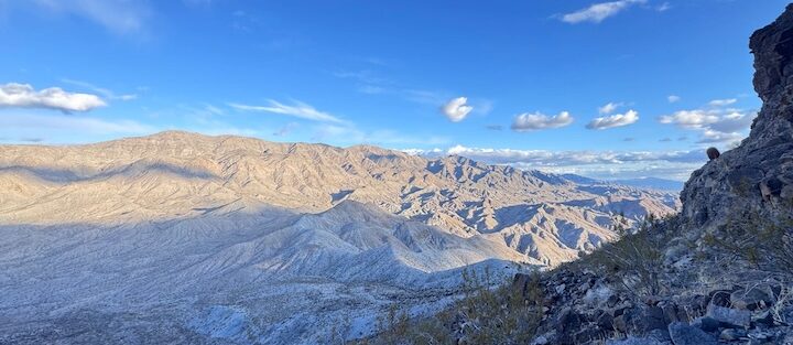
Red Rock Canyon National Conservation Area
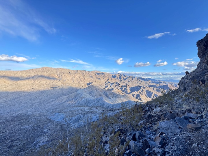
Red Rock Canyon is 17 miles from the Strip and runs a 13-mile one-way scenic loop with trailhead access to some of the best desert hiking in Nevada. The canyon walls push 3,000 feet overhead. The rock here is more complex and more vertical than Valley of Fire. The trails are more demanding and the solitude is better on weekdays.
The park requires a timed entry reservation from October through May. Book in advance at recreation.gov. Don’t show up without one on a peak weekend.
Kraft Mountain Loop
Distance: 3.6 miles · Elevation Gain: 620 ft
Kraft Mountain is a scrambler’s hike. The loop routes you over ledges, around boulders, and up rocky faces that require hands more than once. The summit sits above the canyon floor with views back toward the Las Vegas Strip, a genuinely surreal combination of desert wilderness and city sprawl. This trail requires comfort on uneven terrain and a willingness to get dirty. Bring a friend who knows how to spot.
Calico Tanks Trail
Distance: 2.3 miles · Elevation Gain: 419 ft
Calico Tanks is the strongest single trail in Red Rock Canyon for views per mile. The route climbs through the Calico Hills, a band of red and cream sandstone, to natural potholes that hold water after rain. The payoff at the top is a full panoramic view of the Las Vegas Valley. Desert foreground, city backdrop, nothing between. Shoot it at sunrise and you’ll have one of the best contrast compositions in southern Nevada. If you can hike one trail at Red Rock, hike this one.
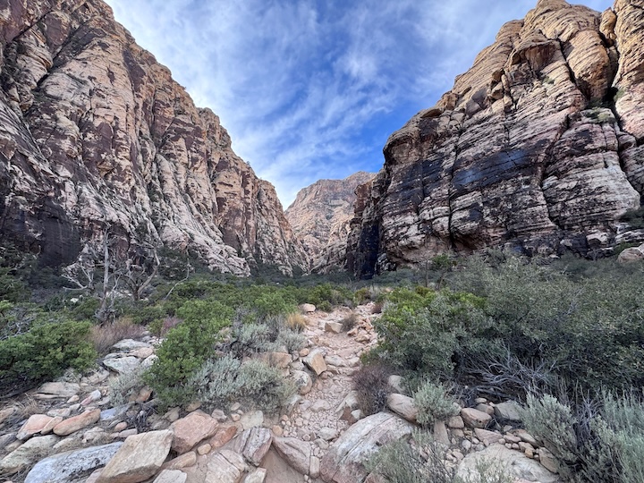
Ice Box Canyon Trail
Distance: 2.1 miles · Elevation Gain: 439 ft
Ice Box Canyon earns its name. The slot canyon walls stay shaded through mid-morning and hold cool air even in spring. The trail follows the canyon floor through massive boulders and narrows to a dry waterfall at the end. When water is running, the falls are a legitimate spectacle. When dry, the canyon geology makes the trip worth it regardless. Good for hot days when shade is the priority.
Lake Mead National Recreation Area
Lake Mead doesn’t get the same attention as the other two parks, but it’s the most varied. Volcanic terrain, canyon walls, historic infrastructure, and an underrated slot canyon make it worth a half-day on its own. The park stretches across Clark and Mohave counties into Arizona, and the eastern trails see fewer crowds than anything at Red Rock.
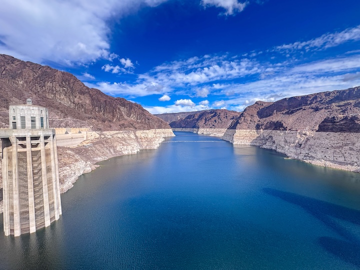
Historic Railroad Tunnel Trail
Distance: 8.2 miles · Elevation Gain: 931 ft
This is the underrated gem of the three parks. The route follows the old railroad bed used to haul materials during Hoover Dam’s construction in the 1930s and passes through five tunnels blasted through volcanic rock. Lake Mead opens up on one side of the trail the entire way. The dam infrastructure becomes visible further along. It’s educational without being boring, the views are consistent mile-to-mile, and the tunnels add genuine atmosphere. Add the Lake Mead and Hoover Dam Walking Tour (1.3 miles, 141 ft gain) to extend the day.
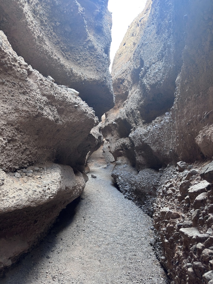
Spooky Canyon
Distance: 0.8 miles · Elevation Gain: Negligible
Spooky Canyon is a slot canyon sitting about 30 feet off the highway, and the trailhead is easy to miss. Once you’re inside, the narrow walls close in and the light does things that make photographers stop walking. Short enough to cover in 30 minutes. The branching side passages add time if you want to dig in. Don’t skip it just because it’s short.
Fortification Hill
Distance: 3.5 miles · Elevation Gain: 1,394 ft · Difficulty: Strenuous
This is the hardest hike in this guide. Fortification Hill is a steep, relentless climb with minimal shade, loose rock near the top, and route-finding required for the final push to the summit. Views stretch across Lake Mead and into Arizona. Earn it or skip it. There’s no middle ground. If you’ve already done two or three hikes earlier in the day, save this one for a morning when your legs are fresh and your water is full.
Best Time to Hike Near Las Vegas
Avoid June through August. The heat isn’t a challenge, it’s a hazard. Temperatures regularly hit 110 degrees Fahrenheit in the canyon. If you have no choice but to go in summer, be back at the trailhead before 10 AM. Start no later than 5:30.
For photography: the Fire Wave and Calico Hills shoot best in late afternoon when the rock color saturates. Calico Tanks at sunrise gives you the Las Vegas Valley on the horizon with soft pink light behind you. Fortification Hill at sunset with the lake below is worth every step of the climb.
Rules and Regulations
Valley of Fire State Park charges $15 per vehicle. No climbing on designated formations. Drones require a permit. Stay on marked trails, the cryptobiotic soil crust throughout the park is fragile and takes decades to recover from foot traffic.
Red Rock Canyon charges $20 per vehicle and requires a timed entry reservation from October through May. Book in advance at recreation.gov. No off-trail travel in sensitive areas. The scenic loop is one-way and closes at sunset.
Lake Mead charges $25 per vehicle as part of the America the Beautiful interagency fee structure. No camping outside designated sites except in BLM dispersed camping areas adjacent to the park boundary. Pack out everything you pack in at all three parks.
Where to Stay Near Las Vegas
The Strip works as your base. Marriott Bonvoy properties include the Grand Chateau and Vdara, both close to the freeway ramps you need for early trailhead starts. IHG Rewards members can look at the Holiday Inn Club Vacations at Desert Club Resort, which offers more space and kitchen access for multi-day adventure trips. Hilton Honors options on the Strip include Grand Vacations properties with easy highway access.
For something quieter and cheaper, Henderson and Boulder City both put you closer to Lake Mead with faster access to eastern trailheads and without Strip traffic on the way out.
Camping Nearby
Lovell Canyon in the Spring Mountains puts you at elevation with pine trees and cold nights, a full contrast to the desert floor. It’s free dispersed camping on National Forest land accessed via Kyle Canyon Road off NV-157. Sites fill on weekends from April through October. Get there Friday afternoon or expect to search.
Kingman Wash requires a 4×4 and a willingness to drive a rutted dirt road down toward the lake. The payoff is a secluded lakeside site with views of the canyon walls and silence once the sun drops. I ran Estes down this one in winter and it was the kind of isolation that makes a long trail day feel earned.
Stewart’s Point on Lake Mead is a designated camping area with more accessibility than Kingman Wash, directly on the water with open views across the lake. Good option if dispersed camping isn’t your preference.
Chase the Quiet
The version of Las Vegas I chase isn’t on the Strip. It’s the moment the Ice Box Canyon walls close in and the city noise drops to nothing. It’s 6 AM at Valley of Fire when the red rock turns almost purple and you’re the only person with a camera in the frame. It’s the long drive back through desert dark with the Strip lights glowing on the southern horizon and Estes smelling like sunscreen and trail dust and a full day well spent.
Support the Adventure
To make your walls less boring, check out my photography portfolio and bring a piece of the wild and my story into your home.
If you’d like to fuel future adventures, you can donate a coffee on Ko-Fi. Every cup keeps me chasing sunrises and stories.
When you shop using my affiliate links, every click helps support this blog at no extra cost to you. It’s a small way to keep Unicorn Adventure alive and kicking while I keep exploring.
Subscribe to my mailing list for future updates, new stories, and behind-the-scenes adventures.
Stay connected with me on Instagram and Facebook for more photos and daily inspiration.
Thanks for being part of the journey, Unicorn Squadron!

Theo Maynard is a landscape photographer and adventure blogger based in Salt Lake City. He chases remote desert and mountain light across the American West, documents it all solo, and shares the journey through Unicorn Adventure. He’s on the autism spectrum, and that’s not a footnote, it’s the whole story. He creates to inspire others to get outside, chase what lights them up, and live their best possible life. Unapologetically himself.