

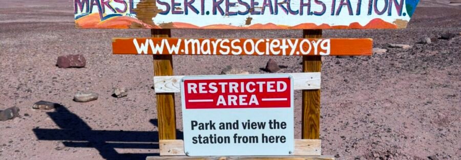
The San Rafael Swell looks like Mars. Someone decided to put a Mars simulation facility in it. The logic tracks.
The Mars Desert Research Station (MDRS) is a working research facility operated by the Mars Society, located about 7 miles northwest of Hanksville on Cow Dung Road. Scientists conduct analog research here, simulating Mars mission conditions in a landscape that genuinely resembles the Martian surface. The facility is not open to the public. What you can do is drive out on Cow Dung Road, park at a respectful distance, and view the cylindrical habitat modules and satellite dishes from outside the perimeter. The surrounding desert landscape is the real draw for most visitors: red and orange sandstone, barren terrain, minimal vegetation, and a geological setting that explains exactly why the Mars Society chose this location.
Here’s what you need to know before making the drive.
Quick Facts
| Destination | Mars Desert Research Station (MDRS) |
| Location | Northwest of Hanksville, Utah, off Cow Dung Road |
| Coordinates | 38.4053, -110.7902 |
| Access | High-clearance vehicle recommended on Cow Dung Road (dry conditions) |
| Public Access | Exterior viewpoint only, no entry to facility or habitat modules |
| Distance | Roadside, short walk from parking along Cow Dung Road |
| Difficulty | Easy |
| Dogs Allowed | Yes (on leash) |
| Fee | None |
How to Get There
From Hanksville, take UT-24 west for approximately 3 miles. Turn right onto Cow Dung Road (the same road that accesses the Bentonite Hills further south). Follow Cow Dung Road approximately 4 miles to the MDRS area. High-clearance vehicle recommended. The road is navigable in dry conditions but the bentonite clay surface becomes extremely slick after any precipitation. Do not attempt access after rain. Load coordinates (38.4053, -110.7902) before leaving Hanksville since cell service is gone well before the turnoff.
Parking Information
No formal parking. Pull off along Cow Dung Road at a safe distance from the station without blocking the road or any access routes. The facility is active research infrastructure, do not drive close to the habitat modules or obstruct the facility perimeter. No restrooms, no facilities. Everything needed comes from Hanksville before you leave.

Cell Service and Navigation
No cell service in this corridor. Download offline maps before leaving Hanksville. The MDRS is a small target in a large landscape and navigating by coordinates before you lose signal is the practical approach. Let someone know your destination and expected return time before heading out.
What to Expect at the MDRS
The Facility
The MDRS consists of cylindrical white habitat modules, a greenhouse, satellite dishes, and research equipment clustered together in the desert. Viewed from outside the perimeter it reads exactly as expected: a science outpost in an alien landscape. If researchers are in residence, you may see activity around the habitat. Treat the facility with the same respect you’d extend to any working scientific installation. Observe from a distance. Don’t approach the modules, equipment, or any personnel.
The Landscape
The terrain surrounding the MDRS is the same red and orange sandstone badlands that make the San Rafael Swell famous. The combination of the facility and the landscape creates a photography opportunity that doesn’t exist anywhere else in Utah. Wide-angle shots that include both the habitat modules and the surrounding desert formations are the primary draw. The area is most visually compelling at sunrise and sunset when the low light enhances the red tones of the sandstone and casts dramatic shadows.
Exploration
The public access component of this stop is brief: view the facility from the road, photograph the landscape, and explore the surrounding desert terrain on foot at a respectful distance from the perimeter. Most visitors spend 30 minutes to 1 hour at the MDRS viewpoint before continuing to the Bentonite Hills or other Cow Dung Road destinations. This is not a hiking destination in its own right, it’s a photography and curiosity stop in the context of a broader Hanksville area day.
Difficulty and Access
The access road is the challenge. Cow Dung Road requires high-clearance in dry conditions and is impassable after rain. At the facility itself, walking from your parking spot along the road to a good viewing angle is easy, flat terrain. This is one of the most accessible stops in the Hanksville area physically, the challenge is entirely in getting there.
Dog Friendly?
Yes. Dogs are welcome on leash. The open desert terrain is manageable for most dogs. Bring more water than you think they need. No shade, no water sources, desert floor heats up fast.

What to Bring
At least 2 liters of water per person. Sun protection. A camera: the landscape-facility combination is the primary purpose of this stop. A wide-angle lens captures the full scene. A telephoto isolates the habitat modules against the sandstone backdrop. A tripod for golden hour. Offline maps loaded before you leave the highway. Dry conditions confirmation before turning onto Cow Dung Road.
Best Time to Visit the MDRS
Spring (March through May) and fall (September through November) are the best windows. Summer heat on the exposed desert road and surrounding terrain is extreme. Winter can produce snow on the surrounding formations that enhances the Martian visual effect, but the clay road in wet or frozen conditions is hazardous. The access road condition check applies year-round: verify dry conditions before committing to Cow Dung Road.
For photography, sunrise is the strongest window. The red sandstone around the facility catches the first warm light and the facility itself is most dramatic when silhouetted against the brightening sky. Sunset from the opposite direction is equally strong. Midday direct sun flattens the landscape and makes the facility look less dramatic against the washed-out sky.

Rules and Regulations
The MDRS is private research infrastructure on public land. The surrounding BLM desert is public land. Visiting the surrounding landscape is permitted. Entering the facility, approaching the habitat modules, or interfering with research equipment or personnel is not. Leave No Trace on the surrounding desert land. No permits, no fees for the public land surrounding the facility. Respect any posted signage around the facility perimeter. Check the BLM Price Field Office for any current access restrictions in the area before heading out.
Where to Stay Near Hanksville
Hanksville is the practical base: basic motels and all the services you need before driving out on Cow Dung Road. For more amenities, Moab is about 2 hours east and Green River is about 1.5 hours north. For points travelers, check available Marriott Bonvoy properties, IHG Rewards hotels, and Hilton Honors options in Moab, Green River, or Salt Lake City along your route.
Camping Nearby
Dispersed BLM camping is available in the surrounding San Rafael Swell terrain. No facilities, no fees, exceptional night sky access. Goblin Valley State Park, about 20 miles east, has a reservable campground with hookups through Utah State Parks for hikers who want established facilities.
Nearby Adventures
Cow Dung Road also accesses the Bentonite Hills, about 4 miles south of the MDRS. The vivid clay color bands are the strongest photography destination on this road and make a natural pairing with the MDRS stop on the same morning. Moonscape Overlook and Factory Butte are in the same UT-24 corridor and round out a full Hanksville area day.
Goblin Valley State Park is about 20 miles east with the Valley of the Goblins and the Goblin’s Lair Trail. Little Wild Horse Canyon (8.0 mi / 787 ft) is the best slot canyon loop in the region. Leprechaun Canyon (2.2 mi / 147 ft) off Highway 95 is the shorter slot canyon option for the same multi-day itinerary.
For the broader Escalante area circuit south of Hanksville, Moki Dugway is one of the most dramatic roads in Utah and works well as a southbound transition toward Cedar Mesa and Monument Valley.
Chase the Quiet
A Mars simulation facility in a Utah desert that looks like Mars. The absurdity is the point, and also not absurd at all. The San Rafael Swell is what it is: remote, geological, otherworldly. The Mars Society found exactly the right place for this. Standing outside the perimeter on Cow Dung Road in the early morning with nobody else present and the habitat modules white against the red sandstone, you understand both why they built it here and why you drove out to see it.
Support the Adventure
To make your walls less boring, check out my photography portfolio and bring a piece of the wild and my story into your home.
If you’d like to fuel future adventures, you can donate a coffee on Ko-Fi. Every cup keeps me chasing sunrises and stories.
When you shop using my affiliate links, every click helps support this blog at no extra cost to you. It’s a small way to keep Unicorn Adventure alive and kicking while I keep exploring.
Subscribe to my mailing list for future updates, new stories, and behind-the-scenes adventures.
Stay connected with me on Instagram and Facebook for more photos and daily inspiration.
Thanks for being part of the journey, Unicorn Squadron!

Theo Maynard is a landscape photographer and adventure blogger based in Salt Lake City. He chases remote desert and mountain light across the American West, documents it all solo, and shares the journey through Unicorn Adventure. He’s on the autism spectrum, and that’s not a footnote, it’s the whole story. He creates to inspire others to get outside, chase what lights them up, and live their best possible life. Unapologetically himself.