Most things worth doing in Moab require driving at least 20 minutes out of town. Mill Creek is the exception. The trailhead is about a mile south of Main Street, the hike is 1.5 miles roundtrip, and at the end of it there’s a waterfall and a swimming hole in a red rock canyon that feels like it was kept secret on purpose. Cottonwood trees shade sections of the creek. Petroglyphs sit carved into the canyon walls. The water is cold enough to be actually refreshing and not just cold-in-theory.
This guide covers the Mill Creek Waterfall trail: how to get there, what the creek crossing situation actually is, when to go, and what makes this particular canyon worth an hour of your Moab day.
Quick Facts
|
Trail Name |
Mill Creek Waterfall Trail |
|
Location |
Moab, Utah (BLM land) |
|
Coordinates |
|
|
Distance |
1.5 miles roundtrip |
|
Elevation Gain |
Approx. 60 feet |
|
Difficulty |
Easy |
|
Time |
45-75 minutes |
|
Dogs Allowed |
Yes, on leash |
|
Fee |
None |
|
AllTrails |
How to Get There
From downtown Moab, head south on US-191 for about a mile, then turn left onto Powerhouse Lane. Follow Powerhouse Lane to the Mill Creek trailhead parking area. The drive from Main Street takes under five minutes, which makes this the most accessible canyon hike in the Moab area by a wide margin.
From Salt Lake City, plan about 4 hours to Moab: I-15 south, US-6 east, US-191 south. From Grand Junction, Colorado, roughly an hour west. Once you’re in Moab, Mill Creek is an afterthought to get to. No highway navigation required, no permit, no entry fee.
Parking Information
The Mill Creek trailhead parking lot is small and fills up fast, especially on warm weekends when the swimming hole draws a crowd. Spring, summer, and fall mornings can see the lot full by 9 or 10 a.m. Arrive early or plan for a street parking walk-in from Powerhouse Lane.
No facilities at the trailhead. Moab has everything you need within a mile, so sort out food, water, and restrooms before you leave town. The hike is short enough that you won’t be gone long, but the canyon doesn’t have anything to offer in terms of supplies.
Cell Service and Navigation
Cell coverage is generally fine for this hike. You’re close enough to Moab that signal holds for most of the trail. Don’t rely on it for navigation anyway: the trail is straightforward and follows the creek. You’re not going to get lost.
Download AllTrails offline as a habit before any canyon hike in the area, but for Mill Creek specifically, navigation isn’t the challenge. The creek crossings are.
What to Expect on the Mill Creek Waterfall Trail
The Trail
The trail leaves the parking area and enters a canyon corridor almost immediately. Red canyon walls rise on both sides. Cottonwood trees line the creek and provide real shade during the warmer months, which is a genuine luxury on a Moab trail in July. The path alternates between sandy stretches, rocky sections, and the creek itself.
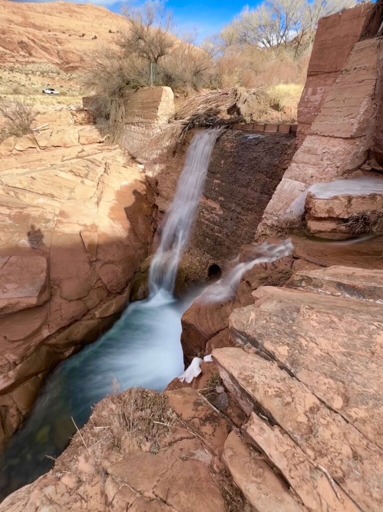
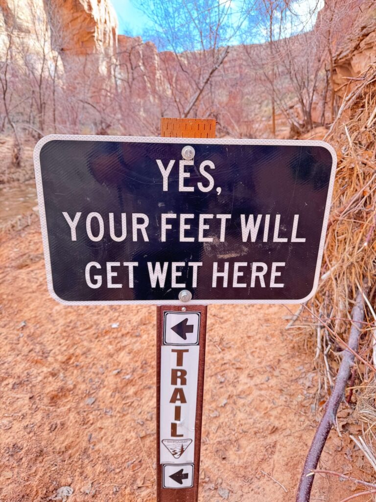
You’ll cross Mill Creek multiple times on the way to the waterfall. The crossings are shallow in most conditions, ankle-to-knee depth depending on season and recent precipitation, but they require wet feet unless you’re willing to jump rocks in low water. Wear shoes you’re comfortable getting wet or bring sandals to swap into at the crossings. Flip-flops are the wrong answer for the rocky sections between crossings.
Petroglyph panels are visible on the canyon walls at a couple of points along the trail. They’re ancient, they’re protected, and they’re easy to miss if you’re not looking up. Look up.
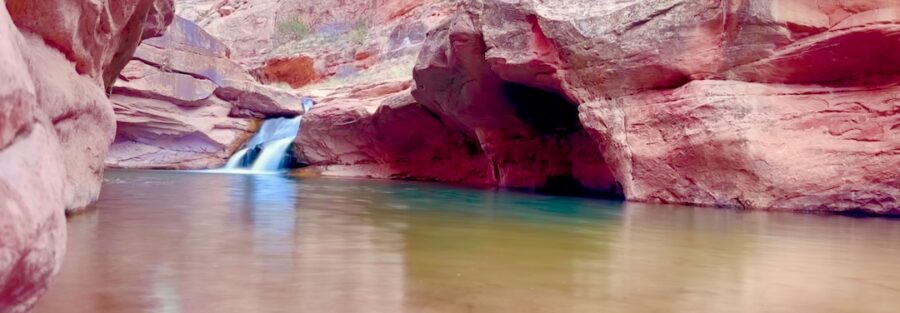
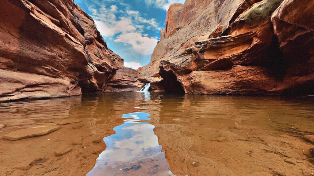
The Waterfall and Swimming Hole
The waterfall sits roughly three-quarters of a mile in and is the obvious endpoint for most visitors. It drops into a pool that’s deep enough to swim in and cold enough to be genuinely refreshing after walking under the desert sun. In summer, this pool is a legitimate destination in its own right, especially for kids and dogs who want water engagement without a long approach.
The canyon walls frame the waterfall tightly and the light in the pool area is interesting in the morning hours when the sun angles over the east rim. For photography, the waterfall works best with a slower shutter speed to blur the water, which means a tripod or at least a stable surface for the camera. The pool reflection can also work well in the calm sections when there’s no wind.
Swimming is allowed in the designated areas. Follow posted signage for current restrictions. The pool at the waterfall is the primary swim zone. Respect any seasonal closures, which sometimes go up during drought or water quality concerns.
Trail Difficulty and Length
Easy is accurate. The 1.5-mile roundtrip has negligible elevation gain and no technical terrain beyond the creek crossings. Those crossings can be slippery on wet rocks, so take them carefully, but they’re not a fitness challenge. Budget 45-75 minutes for the round trip with time at the waterfall.
The trail is appropriate for all fitness levels including families with young kids, older adults, and anyone who wants a genuine canyon experience without a significant physical commitment. If your kids are water-happy, budget extra time at the pool. They will not be ready to leave when you are.
Dog Friendly?
Yes. Mill Creek is one of the best dog-friendly hikes in the Moab area, full stop. Dogs are welcome on leash and the creek crossings and swimming hole give water-loving dogs a chance to actually enjoy themselves rather than just tolerate the heat. Keep dogs leashed throughout and pack out waste.
A few practical notes: the creek crossings require you to manage your dog across moving water, which is straightforward for most dogs but worth thinking through in advance for anxious or reactive animals. The rocky sections between crossings have sharp edges that can cut paw pads on dogs that haven’t built up toughness. If your dog is a pavement creature, watch for limping on the rocky stretches.
What to Bring
Water shoes or shoes you don’t mind getting wet. A dry bag or waterproof case for your phone and camera if you’re wading through the crossings. A towel if you plan to swim. Dog water and a collapsible bowl.
Sun protection for the approach sections without shade. A light daypack handles everything, and this is short enough that even a small hydration pack works fine. For photography, a waterproof camera bag or dry bag for the creek crossing sections is worth the two seconds of peace of mind.
Best Time to Hike Mill Creek
Spring and fall are the prime windows: March through May and September through November. Water levels are typically at their best in spring from snowmelt and early season rains, which means a fuller waterfall and a more substantial swimming hole.
Summer is when this trail earns its reputation as a heat-escape destination. The swimming hole becomes genuinely popular in July and August, which means a crowded parking lot and a busier trail by mid-morning. Get there before 8 a.m. in summer if you want the canyon to yourself. The creek crossing is deeper and faster in spring than summer, so check conditions after wet weather.
Winter visits are possible and often beautiful. The cottonwood trees are bare and the light on the canyon walls is different, lower and more orange. Water levels are typically lower in winter, which can reduce the swimming hole’s depth, but the waterfall still runs. Ice on the rocky crossing sections requires extra caution.
For photography, early morning is the best window. The east-facing canyon catches morning light first, and the waterfall pool reflects it well before the sun gets overhead. The filtered light through the cottonwood canopy in late spring and early fall is worth shooting on its own.
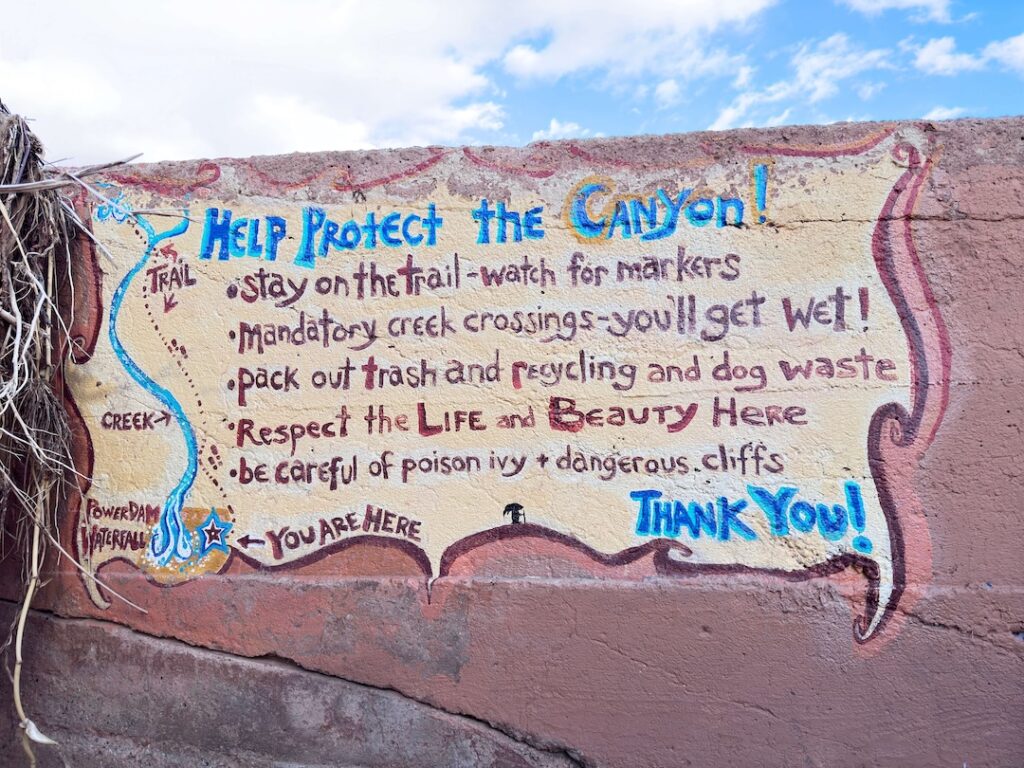
Rules and Regulations
No fires. No camping. Swimming is allowed in designated areas only, follow posted signage for current restrictions. Dogs must be leashed at all times. Pack out all trash and dog waste.
The petroglyph panels on the canyon walls are protected under federal law. Do not touch, chalk, or alter them in any way. Stay back and photograph from a respectful distance. The carvings are irreplaceable and degrading, you accelerate that with contact.
Mill Creek is on BLM land managed jointly with the City of Moab. Leave No Trace principles apply. The canyon sees heavy use relative to its size, which makes every individual decision about impact matter more than it would on a remote backcountry trail.
Where to Stay Near Moab
You’re already in Moab. Mill Creek is a mile from downtown, so wherever you’re staying in town works. The trail is more of a morning warm-up or afternoon cool-down than a destination that requires planning lodging around it. Red Cliffs Lodge on the Colorado River on Highway 128 and The Caves at Moab are two options with more character than standard chain rooms. For points travelers, check Marriott Bonvoy properties in Moab, IHG Rewards hotels near Moab, and Hilton Honors options in the area. Book well ahead for spring and fall.
Camping Nearby
Camping is not permitted at the Mill Creek trailhead or within the canyon. For camping near Moab, the Sandflats Recreation Area east of town has both dispersed and fee sites with facilities. Porcupine Rim and the Gemini Bridges area offer dispersed BLM camping for overlanders. Private campgrounds in Moab, including Moab KOA and Canyonlands Campground, offer hookups and facilities if you want something more structured.
Nearby Adventures
Grandstaff Canyon Trail (formerly Negro Bill Canyon) is the natural step up from Mill Creek for hikers who want more. It’s 5.7 miles roundtrip with 836 feet of gain and leads to Morning Glory Bridge, one of the longest natural rock spans in the country. It’s accessible from Highway 128 a few miles northeast of Moab and allows dogs on leash.
For arch hikes, Corona Arch Trail on Potash Road is the best dog-friendly arch experience in the Moab area. 3.0 miles roundtrip, no entry fee, massive arch.
Inside Arches National Park, Delicate Arch is the iconic Utah experience, 3.2 miles roundtrip. The Sand Dune Arch Trail is an easy 0.4-mile hike through a shaded slot to a tucked-away arch. Neither allows dogs inside the park.
Dead Horse Point State Park is 30 minutes from Moab and delivers a canyon overlook that earns the drive. Canyonlands Island in the Sky is a full separate day. For OHV drivers, Hurrah Pass leaves from downtown Moab on Kane Creek Boulevard and is dog-friendly BLM terrain for 20 miles roundtrip.
In town: Quesadilla Mobilia for tacos, Canyon Pizza for post-hike carbs. The Mill Creek Parkway, a paved multi-use path along the creek corridor through town, is worth knowing about if you have dogs and want a flat, easy walk that connects to the trailhead from central Moab.
Plan This Hike
AllTrails has Mill Creek Waterfall Trail mapped with offline capability. Plan your hike on AllTrails and pull the offline map before you leave the parking lot.
Chase the Quiet
Mill Creek is a mile from downtown Moab and most visitors to the area never hike it. The trail isn’t a secret, but its proximity to town and its relative ease compared to the marquee park hikes keeps it lower on most itineraries than it should be. A waterfall in a red rock canyon, swimming-hole cold water, cottonwood shade, and petroglyphs on the walls. That’s the trail. The fact that it starts a mile from Main Street is part of what makes it good, not a knock against it.
Support the Adventure
To make your walls less boring, check out my photography portfolio and bring a piece of the wild and my story into your home.
If you’d like to fuel future adventures, you can donate a coffee on Ko-Fi. Every cup keeps me chasing sunrises and stories.
When you shop using my affiliate links, every click helps support this blog at no extra cost to you. It’s a small way to keep Unicorn Adventure alive and kicking while I keep exploring.
Subscribe to my mailing list for future updates, new stories, and behind-the-scenes adventures.
Stay connected with me on Instagram and Facebook for more photos and daily inspiration.
Thanks for being part of the journey, Unicorn Squadron!

Theo Maynard is a landscape photographer and adventure blogger based in Salt Lake City. He chases remote desert and mountain light across the American West, documents it all solo, and shares the journey through Unicorn Adventure. He’s on the autism spectrum, and that’s not a footnote, it’s the whole story. He creates to inspire others to get outside, chase what lights them up, and live their best possible life. Unapologetically himself.