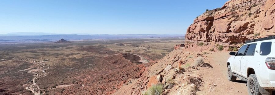
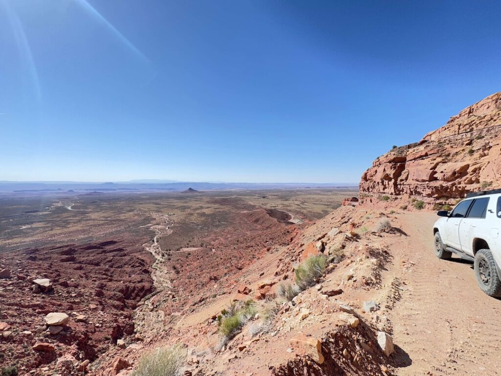
If you’ve ever wanted to drive a road that feels more like a dare, Moki Dugway is your ticket. This gravel drive carves into the edge of Cedar Mesa in southeastern Utah, climbing over 1,200 feet in just three miles while snaking up sheer sandstone cliffs with zero guardrails. It’s short. It’s sharp. It’s totally unforgettable. And it’s the kind of place that reminds you why solo adventure matters, why getting out there and testing yourself against the wild is where the real living happens. I roll through here regularly in Estes, my 4Runner, and every time, something clicks. The views, the exposure, the raw geology, the quiet.
Quick Facts
Route Name | Moki Dugway |
Location | Cedar Mesa, Mexican Hat, Utah |
Coordinates | |
Distance | 3 miles |
Elevation Gain | 1,200 ft |
Difficulty | Easy to Moderate |
Time Required | 1 to 2 hours |
Dogs Allowed | Yes |
Fee | Free |
How to Get There
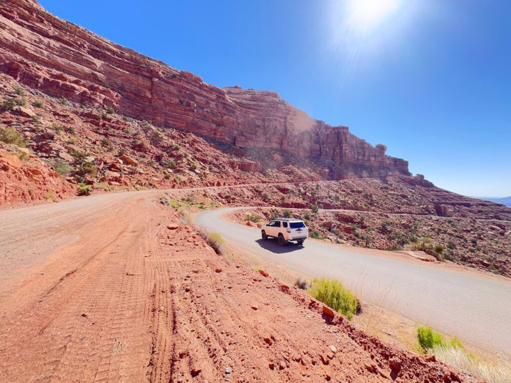
You’ll find Moki Dugway along Utah Highway 261, about 24 miles north of Mexican Hat. Coming from Monument Valley, it’s just under an hour’s drive. Look for the sign that reads “Impassable When Wet.” They’re not kidding. The road starts paved, then transitions to gravel as you climb up the mesa toward the switchbacks. Two-wheel drive vehicles can usually manage the route, but a high-clearance vehicle gives you real confidence. Four-wheel drive makes the descent feel like a controlled thrill instead of a white-knuckle slide down rocks.
Cell Service and Navigation
Cell signal up here is spotty at best. This is deep desert. Download your maps ahead of time, whether you use Google Maps offline or an app like AllMaps or Gaia GPS. A physical map of the area is also smart. GPS works fine, so set your waypoints before you lose service. Make sure someone knows where you’re headed and when you plan to return. This isn’t a trail where you want to rely on signal to find your way back.
What to Expect on Moki Dugway
The Road
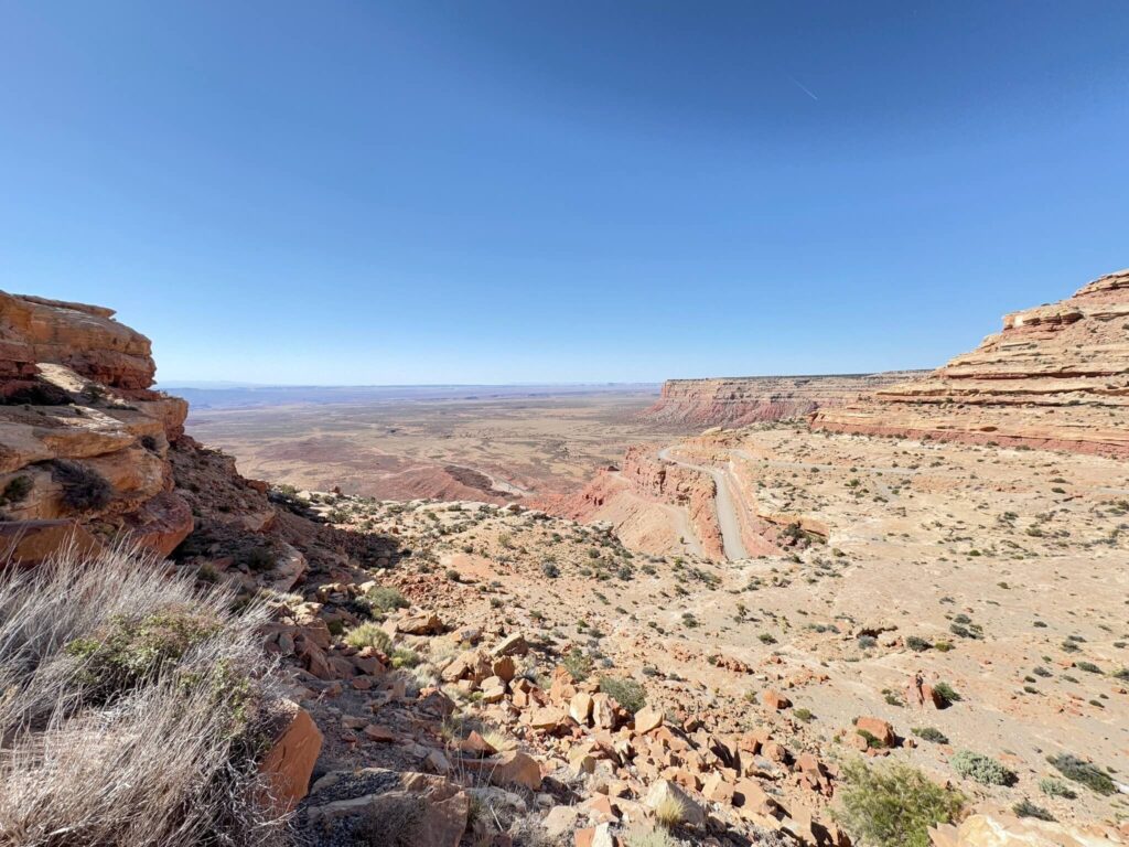
Moki Dugway is all switchbacks and exposure. The gravel surface is graded but rough in spots, with sharp turns and steep drop-offs. No guardrails. None. The road climbs hard, and the view west toward Valley of the Gods and Monument Valley pulls your attention constantly. Don’t let it. Keep your eyes on the road and both hands on the wheel. Slow down on the turns. Drive this with respect.
The Geology and Views
The landscape here is unreal. Red rock formations stretch for miles. The air is dry, clean, smells like sagebrush and dust. At the top of the mesa, Cedar Mesa opens up like a secret, wide and flat and ancient, scattered with junipers. Sunrise and sunset hit different up here. Shadows stretch forever, and the sky goes pink and orange behind jagged rock silhouettes. Photography light is golden. If you’re chasing that shot, morning or late afternoon is where the magic lives.
Drive Difficulty and Length
3 miles doesn’t sound like much. But Moki Dugway will demand your full attention the entire way. The gravel is decent in dry conditions, but after rain, it turns slick and dangerous fast. The switchbacks are tight. The drop-offs are real. This is not a place to zone out or speed. In good weather with a decent vehicle, it’s manageable for most drivers. In bad weather, it can be genuinely sketchy or even closed. Always check conditions before you go. Talk to locals. Trust your instincts.
Dog Friendly?
Yes, dogs are welcome. Keep them leashed if you stop to take in the view. The drop-offs are no joke. The road gets dusty, and dust irritates eyes and lungs, so bring extra water for your pup. Don’t leave them in the car while you explore. It heats up fast out here, especially in summer. A 30-minute stop can turn dangerous for a dog trapped inside.
What to Bring
Pack water. More water than you think you need. Snacks. Sunscreen. A hat. Layers. The weather shifts fast up here. A quality pair of hiking boots makes sense if you plan to explore at the top. Binoculars for spotting distant landmarks. A good camera if you’re chasing light. Offline maps. A first aid kit. And if you’re driving something with high clearance, a basic recovery kit, jumper cables, and spare tire are all smart moves in remote country.
Best Time to Drive Moki Dugway
Spring and fall are prime. March through May and September through early November offer cooler temps, clearer skies, and better light for photography. Summer is blazing hot and dangerous for pets and people alike. Daytime temps hit 100+. Winter brings snow and mud, which can make the Dugway sketchy or even closed. The best light for photography comes at sunrise or late afternoon when shadows stretch long and the sky shifts warm. If you’re timing a visit for that golden-hour magic, aim for these shoulder seasons and shoot early or late in the day.
Rules and Regulations
Moki Dugway is public and free to access. It’s maintained by the Utah Department of Transportation. No permits needed. But respect matters out here. Pack out everything you pack in. Stay on the road. Off-roading beyond this route is strictly forbidden to protect the fragile desert landscape. Fires aren’t allowed. Camping is not permitted directly on the Dugway. Nearby campgrounds and BLM land give you options, which we’ll cover below.
Where to Stay Near Mexican Hat and Monument Valley
For a hotel stay, Monument Valley’s The View Hotel is iconic, right on Navajo Tribal Park property with killer sunrise views. Bluff, Utah, 30 minutes south, has smaller options and a real small-town vibe. Plan to either camp or drive to nearby towns for accommodations. For points travelers, check available Marriott Bonvoy properties, IHG Rewards hotels, and Hilton Honors options in the broader Four Corners area.
Camping Nearby
Muley Point has dispersed camping with unreal views of the San Juan River far below. Valley of the Gods Road offers more dispersed spots along the drive. Recapture Reservoir northeast of Bluff has established camping with water and amenities. Goosenecks State Park, south of Mexican Hat, has a campground with vault toilets and picnic areas. Comb Ridge BLM land around the area has multiple dispersed spots, though water is scarce, so come prepared. Check current BLM regulations before you camp, as closures and fire restrictions change seasonally.
Nearby Adventures
Muley Point Road at the top of the mesa leads to a killer overlook of the San Juan River’s tight meanders. Valley of the Gods is a 16.3-mile dirt loop that feels like Monument Valley’s cooler, less crowded cousin. Goosenecks State Park offers unreal views of the San Juan River’s winding curves. Bluff Fort in the town of Bluff tells the story of early settlement. Navajo-operated trading posts in Monument Valley are worth visiting for authentic goods and cultural connection. Natural Bridges National Monument to the north showcases some of the oldest natural arches in North America without the Moab crowds.
Plan This Drive
AllTrails is a solid tool for planning your route and reading reviews from other drivers who’ve tackled Moki Dugway. You can download offline maps, pin waypoints, and share your route with friends. The community there often flags hazards and seasonal issues, which matters for a drive this exposed.
Chase the Quiet
Moki Dugway does something strange to you. It slows you down. Makes you present. Every switchback demands focus. Every view stops your breath. And when you reach the top and look back at what you just drove, something shifts. You realize you’re capable of more than you thought. You realize the world is bigger and wilder than you tell yourself when you’re trapped in routine.
Support the Adventure
To make your walls less boring, check out my photography portfolio and bring a piece of the wild and my story into your home.
If you’d like to fuel future adventures, you can donate a coffee on Ko-Fi. Every cup keeps me chasing sunrises and stories.
When you shop using my affiliate links, every click helps support this blog at no extra cost to you. It’s a small way to keep Unicorn Adventure alive and kicking while I keep exploring.
Subscribe to my mailing list for future updates, new stories, and behind-the-scenes adventures.
Stay connected with me on Instagram and Facebook for more photos and daily inspiration.
Thanks for being part of the journey, Unicorn Squadron!

Theo Maynard is a landscape photographer and adventure blogger based in Salt Lake City. He chases remote desert and mountain light across the American West, documents it all solo, and shares the journey through Unicorn Adventure. He’s on the autism spectrum, and that’s not a footnote, it’s the whole story. He creates to inspire others to get outside, chase what lights them up, and live their best possible life. Unapologetically himself.