There are views in the American Southwest that you work for and views that the desert just hands you. White Rim Overlook is closer to the second category. It’s 1.8 miles roundtrip, essentially flat, and at the end of it you’re standing at the rim of Island in the Sky looking down roughly 1,200 feet to the White Rim Road, the Colorado River threading through the canyon far below, Monument Basin dropping away to the south, and the La Sal Mountains rising to the east. The scale of it catches people off guard. You walked less than a mile. You did not earn this view by conventional hiking metrics. And yet here it is.
This guide covers everything you need to hike White Rim Overlook Trail and build a full Island in the Sky day around it.
Quick Facts
|
Trail Name |
White Rim Overlook Trail |
|
Location |
Canyonlands National Park, Island in the Sky, near Moab, Utah |
|
Coordinates |
|
|
Distance |
1.8 miles roundtrip |
|
Elevation Gain |
Approx. 100 feet |
|
Difficulty |
Easy |
|
Time |
1-1.5 hours |
|
Dogs Allowed |
No |
|
Fee |
$35 per vehicle (America the Beautiful Pass accepted) |
|
AllTrails |
How to Get There
From Moab, head north on US-191 for about 10 miles, then turn left onto UT-313 west toward Canyonlands National Park. Follow UT-313 for roughly 22 miles into the Island in the Sky district and through the park entrance. Inside the park, drive south on the main road about 6 miles to the signed Grand View Point Road turnoff. Turn right and continue approximately 2 miles to the Gooseberry parking area on the left. The White Rim Overlook trailhead is here.
Total drive from Moab is about 40-45 minutes. From Salt Lake City, plan 4.5 hours: I-15 south, US-6 east, US-191 south to Moab, then west on UT-313. From Grand Junction, Colorado, roughly 1.5 hours west.
Check nps.gov/cany before your visit for current entry requirements. Canyonlands has been expanding its timed entry and reservation programs in recent years. The $35 vehicle fee or America the Beautiful Pass covers park entry.
Parking Information
The Gooseberry parking area is small. It serves both the White Rim Overlook Trail and the Gooseberry Trail, so it fills faster than you’d expect for an easy trail. Spring and fall mornings see it at capacity by mid-morning. Arrive early or plan your visit for later afternoon when some early arrivals have cleared out.
No facilities at the trailhead. The Island in the Sky Visitor Center near the park entrance has restrooms and information. Stop there on the drive in if needed, and fill water there as the trail has none.
Cell Service and Navigation
Cell coverage disappears well before the Canyonlands park entrance when you’re on UT-313, and is nonexistent at the Gooseberry parking area. Download AllTrails or the NPS Canyonlands app offline in Moab before heading out.
Navigation on this trail is straightforward. It follows the canyon rim south to the overlook, the route is obvious, and the endpoint is unmistakable. Still, pulling the offline map while you have signal is a good habit for any Canyonlands visit, and it sets you up if you’re combining multiple trails in the district.
What to Expect on the White Rim Overlook Trail
The Trail
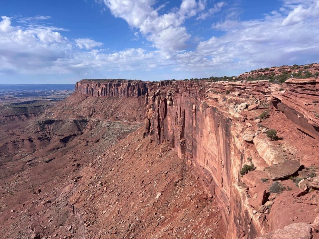
The trail leaves the Gooseberry parking area and heads south along the mesa top through open desert terrain. Pinyon pines and junipers dot the plateau, and the trail surface alternates between packed dirt, sand, and sections of exposed slickrock. It’s mostly flat with a slight undulation and a few rocky steps. Nothing technical. Nothing that requires special footwear or fitness beyond basic ambulatory capability.
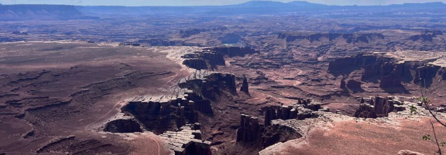
The rim approaches gradually. There’s no dramatic moment where you suddenly gain the overlook. The canyon depth becomes apparent incrementally as the trail angles toward the edge, and then you’re there. Standing on the rim of Island in the Sky looking down at the White Rim, 1,200 feet below, and the Colorado River beyond that.
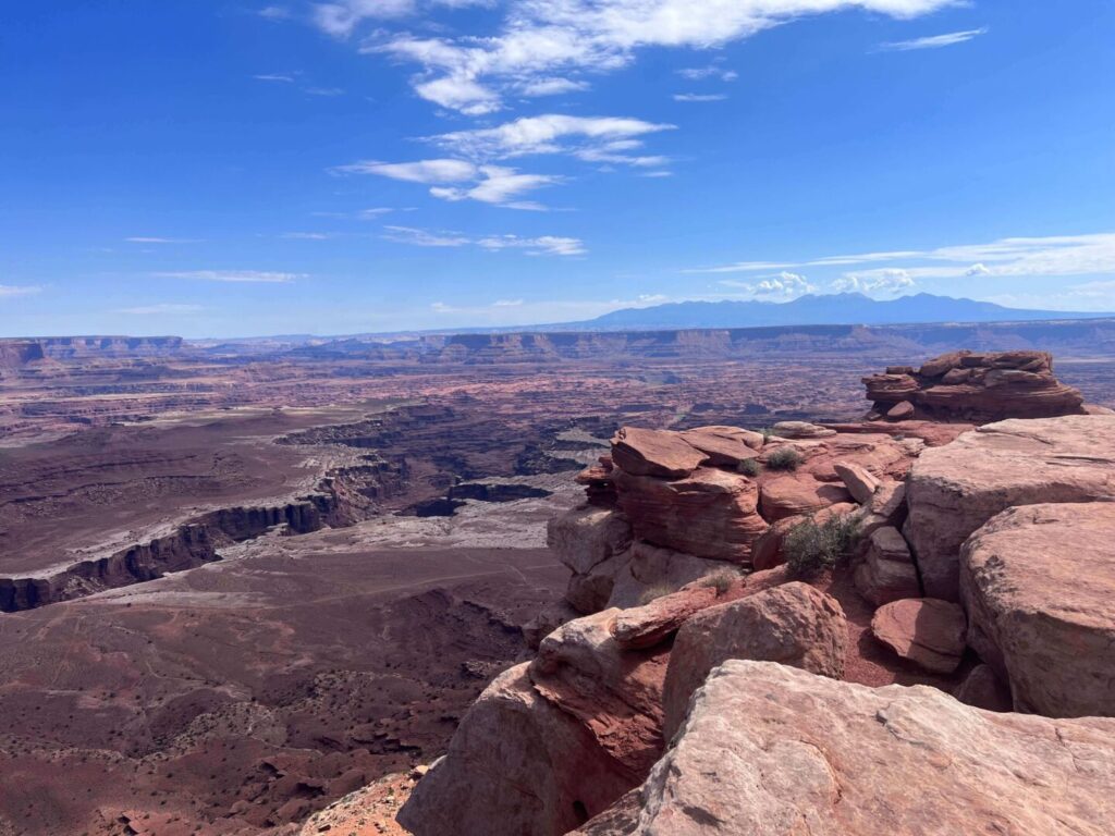
The View
The White Rim is a broad sandstone bench that runs 100 miles around the Island in the Sky mesa, roughly 1,200 feet below the rim you’re standing on. The White Rim Road follows it, a dirt road popular with 4WD vehicles and mountain bikers who do multi-day circuits. From the overlook, you can see sections of that road threading through the canyon below.
Monument Basin drops away to the southeast, its collection of spires and fins creating a landscape that looks built rather than eroded. The La Sal Mountains rise to the east, often snowcapped in spring and fall. The Colorado River, dark and quiet at this distance, snakes through the deeper canyon to the south. On a clear day, the Maze district is visible in the far west. This is one of the biggest views in the park from one of its easiest trails.
![]()
Trail Difficulty and Length
Easy is the right call. The 1.8-mile roundtrip has about 100 feet of elevation change distributed gently across the trail. There are no scrambling sections, no exposure concerns, and no route-finding challenges. This is appropriate for any hiker including young kids, older adults, and anyone who wants a genuinely spectacular view without a strenuous approach.
Budget 1 to 1.5 hours for the round trip with time at the overlook. Photographers and anyone who wants to sit with the view for a while should plan more. The rim is a good lunch spot if you time the hike for midday. Bring something to sit on; the rock is comfortable but the desert heat radiates from it in summer.
Dog Friendly?
No. Canyonlands National Park prohibits pets on all trails, including White Rim Overlook. Dogs are permitted in parking areas, campgrounds, and on paved roads within the park, but must stay leashed and off all unpaved surfaces. For dog-friendly hiking near Moab, Corona Arch Trail on BLM land west of town is the best arch hike that welcomes leashed dogs. The Mill Creek Parkway in Moab is an easy paved option for dogs when the national parks are off the table.
What to Bring
Water is the priority. The trail is short but exposed, and the mesa top in summer or shoulder season can be significantly hotter than Moab itself due to the elevation and open terrain. Bring at least 1-2 liters per person. Sun protection: hat, sunscreen, sunglasses.
Comfortable walking shoes are sufficient. Trail runners or hiking boots are fine. Nothing technical required. For photography, bring a wide-angle lens for the canyon panorama and a longer focal length for pulling in detail on the White Rim Road and Monument Basin below.
Best Time to Hike White Rim Overlook Trail
Spring (March through May) and fall (September through November) are the reliable windows. Temperatures are manageable, the desert light is warm and angled, and the canyon detail is at its most visible in clear low-humidity air.
Summer hiking is feasible on the White Rim Overlook given the short distance, but the mesa top heats up fast and the trail offers minimal shade. Start early if you’re going in summer. Before 8 a.m. is the target. The canyon below holds morning shadow longer than the mesa top, which makes for interesting light on the White Rim itself in the early hours.
Winter visits are quiet and often produce the best photography conditions. The low-angled winter sun creates strong shadow and contrast across the canyon walls and the White Rim below. The trail is rarely icy at this elevation and the solitude is a genuine asset at a viewpoint that crowds in peak season.
For the best photography, late afternoon is the priority window. The canyon faces south and west, and the light on the White Rim and Monument Basin from roughly 90 minutes before sunset turns everything gold and red. If you time a single visit, time it for late afternoon and plan to be at the overlook 2 hours before sunset to watch the light develop.
Rules and Regulations
Stay on the designated trail. Cryptobiotic soil crust covers the mesa top and recovers slowly from foot traffic. Walk on rock where the trail crosses slickrock sections, and on the established path everywhere else.
No pets on the trail. Pack out all trash. Leave No Trace principles apply throughout. No fires outside designated campgrounds. No drones without a special use permit. The $35 vehicle fee or America the Beautiful Pass covers park entry. Check nps.gov/cany for any current reservation or entry requirements before your visit.
Where to Stay Near Moab
Moab is the logical base, about 40 minutes from the White Rim Overlook trailhead. The town has lodging at every price point from budget beds to full river-view resort rooms. Red Cliffs Lodge on the Colorado River on Highway 128 and The Caves at Moab are both options with character. For points travelers, check available Marriott Bonvoy properties in Moab, IHG Rewards hotels near Moab, and Hilton Honors options in the area. Book early for spring and fall.
Camping Nearby
Inside Canyonlands Island in the Sky, Willow Flat Campground is the only developed option. Small, first-come first-served, no water on site. Sites fill quickly in peak season. Arrive the day before and claim your site early if you want to camp inside the park.
The White Rim Road below the overlook is a permitted backcountry camping route for vehicle-based multi-day trips. That’s a different logistical commitment entirely, requiring a permit from the NPS well in advance, but it’s one of the great overland camping experiences in the American Southwest if you have the right rig and the time.
Outside the park, BLM land around Moab has dispersed camping at Gemini Bridges, Porcupine Rim, and the Sandflats Recreation Area. Sandflats has both dispersed and fee sites and is the most convenient base camp option for Moab-area adventures.
Nearby Adventures
Grand View Point is the natural pairing. A short drive further south on Grand View Point Road, the Grand View Point Trail is a flat 2-mile roundtrip to the southernmost point of the Island in the Sky mesa with arguably the biggest view in the park. Do White Rim Overlook in the morning, Grand View Point in the afternoon. Two easy hikes, two completely different canyon perspectives.
Mesa Arch, back north toward the entrance, is the sunrise photography destination in Canyonlands. The 0.5-mile loop is easy and the arch frames the canyon below perfectly in early morning light. If you’re already in the district, it belongs on your list.
Aztec Butte Trail, also in the Island in the Sky district, adds the ancestral Puebloan granary experience and a short but real slickrock scramble to the mix. It’s a moderate hike that pairs well with an easy morning at White Rim Overlook.
Dead Horse Point State Park sits about 10 miles from the Island in the Sky entrance on its own mesa point and delivers a Colorado River canyon overlook from a different angle. Worth a separate stop. The river makes a nearly 360-degree bend 2,000 feet below the viewpoint, and it’s one of the most photographed views in Utah for good reason.
Plan This Hike
AllTrails has White Rim Overlook mapped with offline capability. Download it before you lose signal on UT-313. The app is also useful for adding other Island in the Sky trails to the same day’s plan without needing data in the field. Plan your hike on AllTrails and pull the offline map while you’ve still got signal in Moab.
Chase the Quiet
That’s what I chase. That’s what Unicorn Adventure is about. Getting out there solo, finding the places that still feel wild, and bringing back stories that remind you the world is bigger than your screen.
Support the Adventure
To make your walls less boring, check out my photography portfolio and bring a piece of the wild and my story into your home.
If you’d like to fuel future adventures, you can donate a coffee on Ko-Fi. Every cup keeps me chasing sunrises and stories.
When you shop using my affiliate links, every click helps support this blog at no extra cost to you. It’s a small way to keep Unicorn Adventure alive and kicking while I keep exploring.
Subscribe to my mailing list for future updates, new stories, and behind-the-scenes adventures.
Stay connected with me on Instagram and Facebook for more photos and daily inspiration.
Thanks for being part of the journey, Unicorn Squadron!

Theo Maynard is a landscape photographer and adventure blogger based in Salt Lake City. He chases remote desert and mountain light across the American West, documents it all solo, and shares the journey through Unicorn Adventure. He’s on the autism spectrum, and that’s not a footnote, it’s the whole story. He creates to inspire others to get outside, chase what lights them up, and live their best possible life. Unapologetically himself.