Hike Willis Creek Narrows Trail in Grand Staircase-Escalante near Cannonville, Utah. 5.8 miles of shaded slot canyon, flowing creek, and dog-friendly desert terrain.
Most slot canyons in southern Utah ask something of you. Dry Fork asks you to squeeze. Peekaboo asks you to scramble. Willis Creek Narrows asks almost nothing except that you show up. The trail follows a live creek through 5.8 miles of smooth sandstone narrows, shaded and cool, with walls that glow gold and orange and pink in the right light. The whole thing is accessible to nearly anyone who can walk on uneven ground.
Quick Facts
| Trail Name | Willis Creek Narrows Trail |
| Location | Grand Staircase-Escalante NM, near Cannonville, Utah |
| Coordinates | 37.4831° N, 112.0971° W |
| Distance | 5.8 miles (out and back) |
| Elevation Gain | 1,227 ft |
| Difficulty | Moderate |
| Time | 3-4 hours |
| Dogs Allowed | Yes, on leash |
| Fee | Free (no entrance fee for Grand Staircase-Escalante NM) |
| AllTrails | View on Alltrails |
How to Get There
From Cannonville, head south on Kodachrome Basin Road (the same road that leads to Kodachrome Basin State Park). After a few miles, turn onto Skutumpah Road, also known as BLM Road 500. Drive south approximately 6 miles to the small trailhead parking area on the right.
Skutumpah Road is unpaved dirt and gravel. In dry conditions, most passenger vehicles with reasonable clearance handle it without issue. After rain, the road turns to slick clay and becomes dangerous for any vehicle. High clearance is strongly recommended as a baseline, and check road conditions with the Escalante Interagency Visitor Center at (435) 826-5499 or Cannonville’s visitor resources before heading out if there’s been recent weather.
Cannonville is about 12 miles from Bryce Canyon City on Highway 12 and 9 miles from Kodachrome Basin State Park.
Parking Information
The trailhead parking area is small, with room for 6 to 8 vehicles. It’s unpaved, flat, and free. No permit required, no fee. The trailhead sees far less traffic than the popular Kodachrome Basin and Bryce Canyon trails nearby, so parking is rarely a problem outside of peak spring weekends.
No restrooms, no water, and no services at the trailhead. Bring everything you need from Cannonville or Bryce Canyon City before turning onto Skutumpah Road.
Cell Service and Navigation
Cell service drops off on Skutumpah Road and is gone by the trailhead. Don’t rely on navigation or communication once you leave Cannonville.
The trail is straightforward, an out-and-back following the creek canyon, and you’re unlikely to get seriously disoriented. That said, download the AllTrails map for offline use before you leave. The canyon branches in a few places and having the route confirmed on screen is worth the 30 seconds it takes to download.
GPS satellite signal is reliable throughout the hike even without cell data.
What to Expect on Willis Creek Narrows Trail
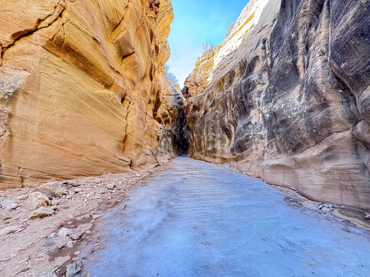
Willis Creek Narrows follows an active stream for most of its length. How much water you encounter depends on the season and recent precipitation. In spring and after summer monsoon rain, the creek runs confidently and you’ll be stepping through water regularly. In late summer and fall dry spells, it can reduce to scattered pools and damp sand. Either way, expect wet feet if you go more than a mile in.
The trail has no formal path. You walk the creek bed itself, picking lines through water, sand, and smooth rock as the canyon dictates. The footing is generally good but requires attention. Water-smoothed sandstone is slicker than it looks when wet. Move deliberately on the submerged rock sections.
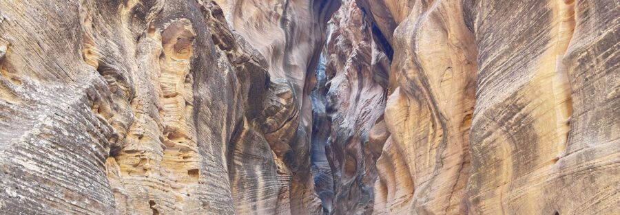
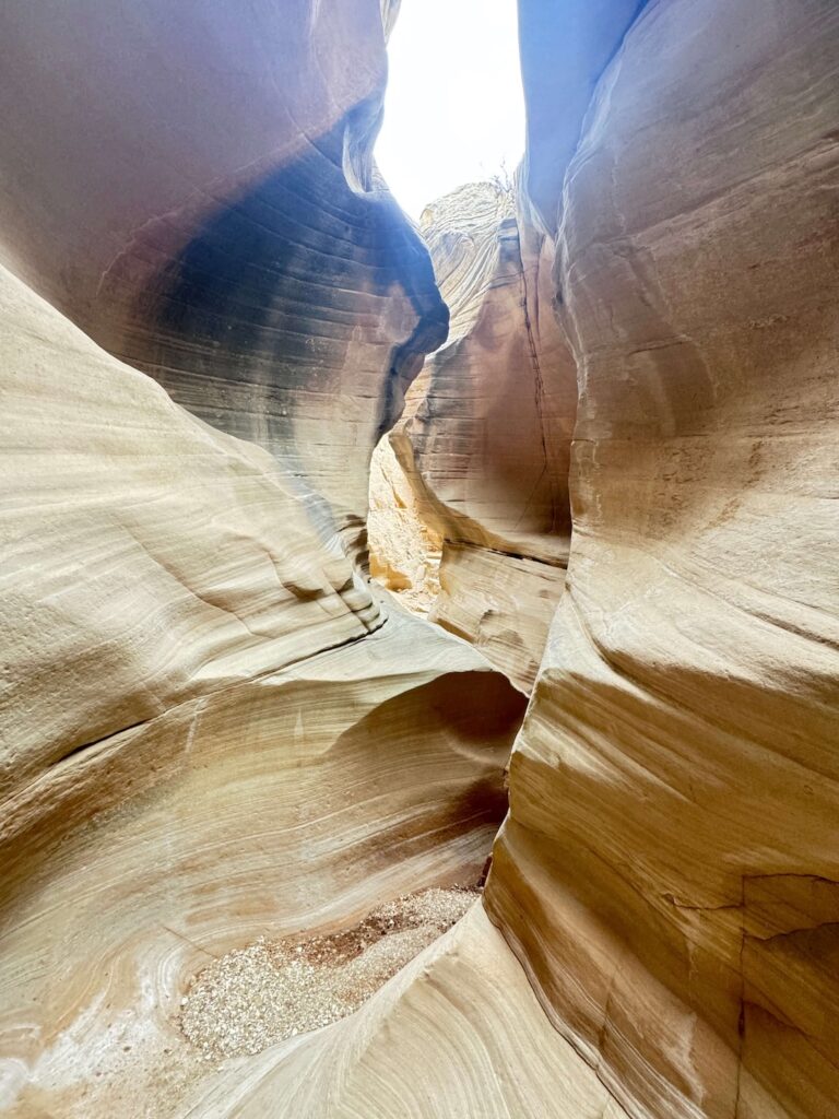
The canyon floor is wide enough in most places to walk without touching the walls, but it narrows significantly in the best sections, squeezing down to just a few feet across. This is not Spooky-level tight, but it’s enough to feel genuinely enclosed in the best possible way.
The sandstone walls at Willis Creek are the reason people come. Smooth, water-polished surfaces in banded layers of gold, orange, red, and pink, curved into organic shapes by centuries of flash floods. The walls change color as the canyon bends and the light angle shifts. Morning light reflects warm off the western faces. Afternoon reverses it.
In the narrowest sections, the walls arc overhead and the sky becomes a thin ribbon of blue at the top of the frame. The light bouncing between surfaces at this point is diffuse and even, ideal for photography without harsh shadows. These sections are where you slow down and let the canyon work on you.
Look for striations and layering in the rock. Each band represents a different geological period. The smooth, rounded shapes at water level were carved by flowing water. Higher up, the texture changes where flood water never reached. The whole cross-section is a timeline written in stone.
Willis Creek is a shaded canyon for most of its length. Direct overhead sun only penetrates the deepest sections briefly around midday, which means the warm bounced light effect, the canyon glow that makes slot canyon photos look impossibly good, is available through most of the morning and afternoon.
Golden hour specifically: the last 45 minutes of afternoon light hits the canyon rim and the tops of the walls turn deep amber while the lower canyon stays in cool shadow. The contrast is striking. For photography, mid-morning is the most consistent window across all sections of the trail.
Trail Difficulty and Length
Willis Creek Narrows is 5.8 miles out and back with 1,227 feet of elevation gain. The original post rates it Easy, but the elevation figure tells a more accurate story: moderate is the honest call. The terrain is not technically demanding, there’s no scrambling or route-finding challenge, but 1,227 feet of gain accumulated over creek-bed hiking on uneven, sometimes slippery surfaces adds up to real physical work.
Budget 3 to 4 hours for the full out-and-back at a relaxed pace. The creek crossings, photo stops, and general canyon-induced slowdown mean you’ll cover ground more slowly than the mileage suggests. That’s not a problem. It’s the point.
Waterproof boots or trail runners are the right footwear. You will get your feet wet. Sandals work in summer but provide no ankle support on the uneven creek bed.
Dog Friendly?
Yes. Willis Creek is one of the better dog-friendly slot canyon hikes in southern Utah. The creek gives dogs natural cooling, the terrain is manageable for most breeds, and the trail sees light enough traffic that encounters with other dogs stay easy to manage.
Keep your dog on a 6-foot leash or shorter. Grand Staircase-Escalante NM requires leashes on all designated trails. Bring water for your dog even with the creek present, standing water in dry stretches can carry bacteria and the creek flow varies.
Watch your dog on the wet sandstone sections. The same slick surfaces that require your attention require theirs. Smaller dogs may need a hand through the deeper water crossings in high flow seasons.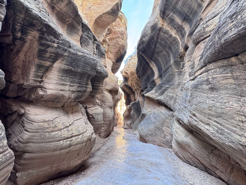
What to Bring
Waterproof footwear is the most important call. Waterproof trail runners or hiking boots keep your feet dry on the shallower crossings. In high water season, sandals with ankle straps work for those who don’t mind wet feet from the start. Whatever you wear, skip anything with smooth soles on the wet sandstone.
Water for the full hike. The creek water is not safe to drink without treatment. Carry a minimum of 2 liters per person.
Sun protection for the approach sections and the canyon rim. The narrows are shaded but the access road and trailhead are exposed. Sunscreen, hat, and sunglasses.
For photography: a wide-angle lens for the canyon wall compositions, a small flexible tripod or gorilla pod for the low-light narrows sections where hand-holding doesn’t give you clean results. Keep your camera accessible but protected from splash. A dry bag or waterproof case is worth the space on high-water days.
Trekking poles for creek crossings, especially useful with a dog on leash when you have only one free hand for balance.
Best Time to Hike Willis Creek Narrows Trail
Spring (April through early June) and fall (September through October) are the best seasons. Mild temperatures, good light, and the creek is more likely to be running in spring after snowmelt.
Summer is manageable due to the canyon shade, but flash flood risk increases significantly during July and August monsoon season. Willis Creek drains a large watershed. Storms miles away can send water down the canyon without warning. Check the weather forecast for the entire region, not just Cannonville, before entering the narrows. Turn around immediately if weather develops.
Winter visits are quiet and can be beautiful, but ice in the canyon is a real hazard. Frozen creek sections and iced-over sandstone are genuinely dangerous. Check conditions before going and bring traction devices for your footwear if there’s any chance of ice.
For photography, mid-morning gives you the best mix of warm light reaching into the canyon and manageable crowds. Early morning puts long shadows on sections of the trail that are already naturally shaded.
Rules and Regulations
Willis Creek Narrows sits within Grand Staircase-Escalante National Monument, managed by the Bureau of Land Management.
Leave No Trace applies throughout. Pack out all trash. There are no facilities on trail.
Stay in the creek bed and on established route. The desert crust surrounding the canyon corridor is cryptobiotic soil, a living biological layer that takes decades to recover from a single footstep off-trail. Walk on rock or sand only.
Flash flood hazard is serious and requires active weather monitoring. Do not enter the canyon if there is any chance of rain in the region.
Dogs must be on leash at all times. No drones in the monument without a BLM permit.
Where to Stay Near Willis Creek Narrows
Cannonville and Tropic are the closest small towns, both on Highway 12 within 15 miles of the trailhead. Options are limited to small motels and vacation rentals. Book ahead for spring and fall weekends.
Bryce Canyon City, about 12 miles from Cannonville on Highway 12, has more lodging options including several lodges near the Bryce Canyon National Park entrance. For loyalty points, Marriott Bonvoy and Hilton Honors have properties in the Bryce Canyon City area. IHG Rewards covers options in Panguitch, about 25 miles west on US-89.
Camping Nearby
Kodachrome Basin State Park, about 9 miles from the Willis Creek trailhead via Skutumpah Road, has a well-maintained campground inside the park with hookup options. One of the better state park campgrounds in southern Utah. Reserve through Utah State Parks and book early for spring and fall.
Dispersed camping is legal on BLM land along Skutumpah Road outside the park boundary. Pull-offs along the road work for vehicle-based camping at no cost. No permit required, Leave No Trace required, check current fire restrictions before any campfire.
Bryce Canyon National Park’s North Campground and Sunset Campground are about 20 miles northwest. Reserve through Recreation.gov. Both fill weeks in advance during peak season.
Nearby Adventures
Willis Creek sits in a productive corner of southern Utah with strong options in every direction.
Kodachrome Basin State Park is the closest neighbor. The Panorama Trail Long Loop covers 5.8 miles through the park’s signature sedimentary spires, a completely different landscape from Willis Creek’s slot canyon terrain. The Kodachrome Nature Trail is the park’s short introductory loop at 0.4 miles.
Bryce Canyon National Park is about 20 miles northwest. The Wall Street, Queens Garden, and Peekaboo Loop covers 6.3 miles with 1,499 feet of gain through the park’s signature hoodoo formations. A full separate day from Willis Creek.
The Escalante Natural Bridge is about 35 miles east in Escalante, a short easy hike to a natural arch spanning the Escalante River. Good add-on if you’re in the area for multiple days.
Lick Wash, accessible further south on Skutumpah Road, is another slot canyon hike with similar character to Willis Creek but fewer visitors. If you’re already on Skutumpah Road, it’s worth checking current conditions and adding it to the itinerary.
Plan This Hike
AllTrails has Willis Creek Narrows mapped with user-reported conditions, recent reviews, and an offline map download. Creek conditions and road conditions on Skutumpah Road both vary significantly with weather. Read the recent reviews before heading out.
For road conditions on Skutumpah Road, call the Escalante Interagency Visitor Center at (435) 826-5499 or check in at the Cannonville Visitor Center before turning south. View on Alltrails
Chase the Quiet
There’s a stretch inside Willis Creek where the walls press close, the creek is running beneath your feet, and the only sounds are water and wind moving through the slot above you. The canyon filters everything else out. Whatever was on your mind when you parked disappears in about half a mile. That’s what slot canyons do when they’re doing their job, and Willis Creek does it reliably.
Support the Adventure
To make your walls less boring, check out my photography portfolio and bring a piece of the wild and my story into your home.
If you’d like to fuel future adventures, you can donate a coffee on Ko-Fi. Every cup keeps me chasing sunrises and stories.
When you shop using my affiliate links, every click helps support this blog at no extra cost to you. It’s a small way to keep Unicorn Adventure alive and kicking while I keep exploring.
Subscribe to my mailing list for future updates, new stories, and behind-the-scenes adventures.
Stay connected with me on Instagram and Facebook for more photos and daily inspiration.
Thanks for being part of the journey, Unicorn Squadron!

Theo Maynard is a landscape photographer and adventure blogger based in Salt Lake City. He chases remote desert and mountain light across the American West, documents it all solo, and shares the journey through Unicorn Adventure. He’s on the autism spectrum, and that’s not a footnote, it’s the whole story. He creates to inspire others to get outside, chase what lights them up, and live their best possible life. Unapologetically himself.