Not every Sedona hike needs to push your limits. Teacup Trail to Coffeepot Rock is 2.6 miles of easy desert walking through classic red rock country, Chimney Rock ahead of you, Capitol Butte to the north, and Coffeepot Rock growing larger as you close the distance. Named for its striking resemblance to an old percolator, the formation is one of Sedona’s most recognizable and one of the most satisfying landmarks to walk toward at golden hour when the sandstone goes full orange.
Teacup Trail is the kind of hike I recommend to people who ask where to start in Sedona. Low stakes, high payoff, and enough visual variety in 2.6 miles that you never feel like you’re just putting in distance.
Quick Facts
|
Location |
Coconino National Forest, Sedona, Arizona |
|
Coordinates |
34.8743, -111.7965 (Sugarloaf Trailhead) |
|
Distance |
2.6 miles (out and back) |
|
Elevation Gain |
269 ft |
|
Difficulty |
Easy |
|
Time |
1.5 hours |
|
Dogs Allowed |
Yes, on leash |
|
Fee |
Red Rock Pass required ($5/day or $15/week) |
How to Get There
The Teacup Trail starts from the Sugarloaf Trailhead in a residential area north of downtown Sedona. From AZ-89A, turn north onto Mountain Shadows Drive. Follow it to Maxwell House Drive, then left onto Buena Vista Drive. The trailhead parking area is at the end of Buena Vista Drive. The drive is short and fully paved. Use GPS routed to the Sugarloaf Trailhead for the most direct approach.
Parking Information
The Sugarloaf Trailhead parking lot is small, maybe 15 to 20 spaces, and fills quickly on weekends and during peak season. A Red Rock Pass is required: $5 for a day pass or $15 weekly. Purchase at the kiosk or online before you arrive. If the lot is full, limited street parking exists in the surrounding residential neighborhood. Park legally, do not block driveways or fire hydrants, and keep noise down since this is a neighborhood trailhead. No restrooms or water at the trailhead.

Cell Service and Navigation
Cell coverage is reliable at the Sugarloaf Trailhead and throughout most of Teacup Trail. You’re close enough to Sedona proper that Verizon and AT&T both hold well. The trail is well-marked and easy to follow. Download an offline map as standard practice. AllTrails documents the route clearly and marks the key Coffeepot Rock viewpoint. No navigation challenges on this one, just stay on the trail and follow it toward the rock.
What to Expect on Teacup Trail to Coffeepot Rock
The Trail
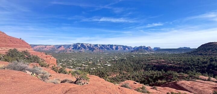
The Teacup Trail moves through open red rock desert from the first step. Packed dirt and sandy sections, a few rocky stretches, minimal shade. The path winds northwest through juniper scrub and prickly pear cactus with Chimney Rock and Capitol Butte framing the view ahead. Elevation gain is gentle and gradual throughout. This is not a trail that tests your legs. It’s a trail that gives you room to look around.
Coffeepot Rock
Coffeepot Rock earns its name. The formation rises from the desert floor in the distinct profile of an old percolator, the spout and handle both visible from the approach trail as you close the distance. The main viewpoint sits at the end of the out-and-back with Coffeepot filling the frame above you. The surrounding formations, Chimney Rock, Capitol Butte, and the broader red rock basin, give the viewpoint a layered depth that rewards a wide lens. Midday light is flat and harsh here. Come at golden hour and the sandstone goes electric.
The Light
Sunset is the prime time on this trail. Teacup Trail faces west toward Coffeepot Rock, and the last hour of light hits the formation and the surrounding buttes in warm orange and red before fading. The residential area behind the trailhead drops away quickly once you’re on trail, and the view from the Coffeepot viewpoint at dusk feels removed from Sedona’s busier corridors. Sunrise works too if you’re coming from the east and want the light behind you on the walk in.

Trail Difficulty and Length
Teacup Trail to Coffeepot Rock is 2.6 miles round trip with 269 feet of elevation gain. It is a genuinely easy trail appropriate for families, beginners, and anyone looking for a shorter day. The surface is mostly packed dirt and sand with occasional rocky sections. No scrambling, no steep grades, no exposure. Comfortable trail shoes handle it well. The lack of shade is the one real consideration, carry water and sunscreen regardless of season.
Dog Friendly?
Teacup Trail is dog-friendly with leash required. The sandy path is easy on paws and the trail is wide enough to move comfortably with a dog in tow. Minimal shade means the surface heats up fast in summer. Bring water for your dog and start early on hot days. Watch the trail edges for prickly pear cactus. Pack out all waste.

What to Bring
At least a liter of water per person. More in summer. Sunscreen, a hat, and sunglasses for the exposed trail. Comfortable trail shoes cover this terrain without drama. A camera is worth the pack weight, the Coffeepot Rock viewpoint rewards a telephoto for detail shots and a wide lens for the full red rock panorama.
Best Time to Hike Teacup Trail to Coffeepot Rock
Spring (March through April) and fall (October through November) are the classic windows in Sedona, temperatures in the 60s and 70s and the red rock light at its richest. Summer is workable with an early start. The trail has no shade and the desert surface radiates heat by 10 a.m. in July and August. Get there at sunrise and you’ll be done before it bakes. Winter is quiet and cool, the best time for empty trails and contemplative pacing. Sunset photography from the Coffeepot viewpoint is exceptional year-round. Plan to be at the rock with at least 30 minutes of golden hour remaining to find your shot.
Rules and Regulations
Teacup Trail sits within Coconino National Forest. Stay on the designated trail. The desert vegetation along the edges is fragile and does not recover quickly from off-trail foot traffic. No graffiti on rock formations. No campfires. No drones. No rock, plant, or artifact collection. Pack out everything you carry in. This is a neighborhood trailhead, keep noise low at the parking area and on the approach to respect the residents who live here.
Where to Stay Near Sedona
The Sugarloaf Trailhead is one of the closest trailheads to Uptown Sedona, making it easy to stay centrally and walk or drive a few minutes to the start. For points travelers, Marriott Bonvoy covers Sedona and the Verde Valley. IHG Rewards has properties in the region. Hilton Honors covers Sedona-area Hampton Inn and other options. Uptown Sedona puts you closest to this trailhead and keeps you near food, galleries, and the AZ-89A corridor.
Camping Nearby
Dispersed camping on Schnebly Hill Road is the closest free option, 15 minutes south of Sedona with canyon views and multiple pull-offs on Coconino National Forest land at no cost with a 14-day stay limit. The Fox Borough area along Schnebly Hill Road offers the most established pull-offs. Nolan Tank and Edge of the World are additional dispersed options in the broader Sedona area. No water or services at any dispersed site.
Nearby Adventures
Fay Canyon Trail is 20 minutes west on Boynton Pass Road, 2.4 miles and 298 feet of gain with a hidden arch and solid canyon shade. Doe Mountain Loop is 2.4 miles and 620 feet of gain with 360-degree mesa views and the best quick summit in the Boynton corridor. Munds Wagon, Cow Pies, and Hangover Loop is the big commitment nearby, 8.2 miles and 1,181 feet of gain with cliffside ledges and panoramic canyon views from the Hangover Trail section. For non-hiking Sedona, the Chapel of the Holy Cross on AZ-179 is the architectural landmark of the area and worth the short walk. Tlaquepaque Arts and Shopping Village is the best stop for local art and a post-hike meal. Airport Mesa overlook is the best free sunset viewpoint in Sedona if you want a secondary stop after Coffeepot Rock.
Plan This Hike
AllTrails has Teacup Trail to Coffeepot Rock well-documented with GPS tracking and current conditions. The route to the Coffeepot Rock viewpoint is clearly marked. Download the offline map before you leave, the residential trailhead area can be slightly confusing to navigate the first time and having the route loaded helps. Plan your hike on AllTrails here.
Chase the Quiet
I got to the Coffeepot Rock viewpoint about 40 minutes before sunset on an October evening. Nobody else out there. The rock turned from its daytime red-orange to something closer to deep amber as the light dropped, Chimney Rock catching the last direct sun to the north, the whole basin going quiet as the temperature started to fall. Two point six miles to get there. That’s the thing about Teacup Trail. The effort is low and the payoff is exactly what you need it to be.
Support the Adventure
To make your walls less boring, check out my photography portfolio and bring a piece of the wild and my story into your home.
If you’d like to fuel future adventures, you can donate a coffee on Ko-Fi. Every cup keeps me chasing sunrises and stories.
When you shop using my affiliate links, every click helps support this blog at no extra cost to you. It’s a small way to keep Unicorn Adventure alive and kicking while I keep exploring.
Subscribe to my mailing list for future updates, new stories, and behind-the-scenes adventures.
Stay connected with me on Instagram and Facebook for more photos and daily inspiration.
Thanks for being part of the journey, Unicorn Squadron!

Theo Maynard is a landscape photographer and adventure blogger based in Salt Lake City. He chases remote desert and mountain light across the American West, documents it all solo, and shares the journey through Unicorn Adventure. He’s on the autism spectrum, and that’s not a footnote, it’s the whole story. He creates to inspire others to get outside, chase what lights them up, and live their best possible life. Unapologetically himself.