

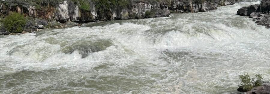
Auger Falls Park is on the floor of the Snake River Canyon about 5 miles from downtown Twin Falls, Idaho. The 4-mile loop trail drops into the canyon via Canyon Springs Road and follows the Snake River past basalt outcrops, riparian vegetation, and the Snake River’s waterfalls, including Auger Falls itself: a series of cascades visible and audible from the trail. Free entry, dog-friendly, accessible to all fitness levels. The Snake River Canyon Rim Trail runs above Auger Falls Park on the canyon rim; the two trails together give Twin Falls hikers both the rim and the river floor experience from the same Snake River Canyon geography.
Quick Facts
| Trail Name | Auger Falls Park Loop |
| Location | Auger Falls Park / Thousand Springs State Park, near Twin Falls, Idaho |
| Coordinates | 42.6211° N, 114.5131° W |
| Distance | 4.0 miles (loop) |
| Elevation Gain | 376 feet |
| Difficulty | Easy |
| Time | 1.5-3 hours |
| Dogs Allowed | Yes, on leash |
| Fee | Free |
| AllTrails | View on AllTrails |
How to Get There
From downtown Twin Falls, take Blue Lakes Boulevard North (US-93) and turn west onto Pole Line Road. Follow Pole Line Road to Canyon Springs Road. Turn south on Canyon Springs Road, which descends into the Snake River Canyon. Follow Canyon Springs Road to the Auger Falls Park parking area. Total drive from downtown Twin Falls is about 10-15 minutes. From I-84, take Exit 173 for US-93 south into Twin Falls, then follow Blue Lakes Boulevard to Pole Line Road and Canyon Springs Road. From Boise, plan about 2 hours east on I-84 to Twin Falls. From Salt Lake City, plan about 3.5 hours north on I-15 and I-84.
Parking Information
Free parking lot at the trailhead with restrooms. The lot is large and fills slowly even on peak days. Auger Falls Park sees far less traffic than the Perrine Bridge / Shoshone Falls visitor infrastructure in Twin Falls, which makes parking a non-issue for most visits. 
Cell Service and Navigation
Cell coverage is solid at the trailhead and along most of the loop given the proximity to Twin Falls. The canyon floor may have partial signal on some carriers. Download AllTrails offline before heading down Canyon Springs Road. The trail is well-marked throughout; navigation is not a challenge.
What to Expect on the Auger Falls Park Loop
Canyon Descent and River Access
The access to the park via Canyon Springs Road is itself a transition: the canyon drops quickly from the Twin Falls plateau into the Snake River floor, with basalt walls rising on both sides. At the canyon floor, the Snake River is close and the scale of the canyon above becomes visible in a way it isn’t from the rim. The loop starts from the parking area and follows the river through the basalt and riparian terrain.
Auger Falls
Auger Falls is a series of Snake River cascades within the canyon, visible and audible from the trail. The falls are not as dramatic as Shoshone Falls to the east but they’re accessible at trail level rather than from a viewpoint above, which makes the experience more immediate. The sound of the cascades is a consistent backdrop through the middle sections of the loop. For photography: the canyon floor and the river are the primary subjects. Morning light reaches the canyon floor before midday; the basalt walls catch direct light in the mid-morning window before the sun rises high enough to create harsh overhead shadows. The river reflections and the falls both work well with slower shutter speeds for the moving water effect. A polarizing filter manages glare on the water.
Riparian and Basalt Terrain
The Snake River riparian zone along this section of the canyon supports dense vegetation that contrasts with the dark basalt cliffs above it. Cottonwoods, willows, and other water-adapted species create a green corridor along the river. Birdlife in the riparian zone is active in spring and fall migration. Raptors use the canyon walls for nesting; watch the basalt cliff faces above the trail throughout the loop. 
Trail Difficulty and Length
Easy is accurate: the terrain is mostly flat with gentle inclines, the surface is well-maintained, and the loop character means you return to the parking area without backtracking. Budget 1.5-3 hours depending on pace and time spent at the falls and viewpoints.
Dog Friendly?
Yes. Dogs are welcome on leash throughout Auger Falls Park. The loop terrain is comfortable for trail-fit dogs. River access points allow dogs to cool off; keep them leashed near the water in sections with current. Bring water for dogs in addition to any river access.
What to Bring
Water: 2 liters for a 4-mile easy loop in summer heat. The canyon floor heats significantly by midday in July and August. Sun protection for the open riparian sections. Sturdy trail shoes for the rocky basalt terrain sections. Camera with waterfall photography setup (tripod, polarizing filter) if falls photography is the goal.
Best Time to Visit
Late spring through early fall. Spring brings the highest Snake River flows, which makes Auger Falls most impressive and the riparian vegetation most active. Early morning visits in summer avoid the canyon floor heat and get the best light on the basalt walls. Fall brings cooler temperatures and migration birding activity in the riparian zone. Winter is possible; the canyon floor remains accessible in most years but ice on the trail requires traction devices after freezing precipitation. 
Rules and Regulations
Stay on designated trails. Leave No Trace principles throughout. Dogs on leash. Pack out all trash; no trash bins on the trail. No fee. Respect the riparian vegetation and the basalt formations; do not remove or damage natural features.
Where to Stay in Twin Falls
Twin Falls has full chain hotel infrastructure on the US-93 / Blue Lakes Boulevard corridor. For points travelers, check available Marriott Bonvoy properties, IHG Rewards hotels, and Hilton Honors options in Twin Falls.
Nearby Adventures
The Snake River Canyon Rim Trail (12.3 miles / 872 ft) is the companion trail above the canyon at rim level: a longer, more exposed route with panoramic views of the canyon that Auger Falls Park Loop passes through below. Together they’re the complete Snake River Canyon Twin Falls hiking catalog. Shoshone Falls Park is about 5 miles east on the Snake River: the waterfall at peak spring flow is 212 feet tall (taller than Niagara) with a park infrastructure that includes viewpoints, picnic areas, and a $5 seasonal parking fee. Worth pairing with Auger Falls on the same day for the Twin Falls waterfall comparison. The Perrine Bridge over the Snake River Canyon in downtown Twin Falls is accessible for viewing and walking; it’s 486 feet above the river and provides the canyon rim viewpoint without a hike. The visitor area below the bridge has interpretive signs about the canyon’s geology and history. The Thousand Springs State Park cluster to the west (Ritter Island Loop, Lemmon Falls, Niagara Springs, Box Canyon Springs, Malad Gorge) extends the Idaho canyon hiking catalog for multi-day Snake River Plain trips from a Twin Falls base.
Plan This Hike
AllTrails has the Auger Falls Park Loop mapped with offline capability and condition reports. Plan your hike on AllTrails and download before heading down Canyon Springs Road.
Chase the Quiet
The Snake River carved this canyon through the basalt of the Snake River Plain over thousands of years, and the canyon is deep enough that standing on the floor of it, the world above disappears. The city of Twin Falls is 500 feet above you on the rim. From the Auger Falls trail you can’t see it, you can’t hear it, and you can’t tell it’s there. That separation is five miles from downtown and a short canyon drive. That’s what makes urban-adjacent canyon hiking worth understanding: the city above and the river below are in the same geography but a different world.
Support the Adventure
To make your walls less boring, check out my photography portfolio and bring a piece of the wild and my story into your home. If you’d like to fuel future adventures, you can donate a coffee on Ko-Fi. Every cup keeps me chasing sunrises and stories. When you shop using my affiliate links, every click helps support this blog at no extra cost to you. It’s a small way to keep Unicorn Adventure alive and kicking while I keep exploring. Subscribe to my mailing list for future updates, new stories, and behind-the-scenes adventures. Stay connected with me on Instagram and Facebook for more photos and daily inspiration. Thanks for being part of the journey, Unicorn Squadron!

Theo Maynard is a landscape photographer and adventure blogger based in Salt Lake City. He chases remote desert and mountain light across the American West, documents it all solo, and shares the journey through Unicorn Adventure. He’s on the autism spectrum, and that’s not a footnote, it’s the whole story. He creates to inspire others to get outside, chase what lights them up, and live their best possible life. Unapologetically himself.