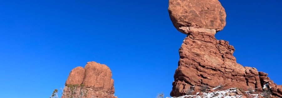
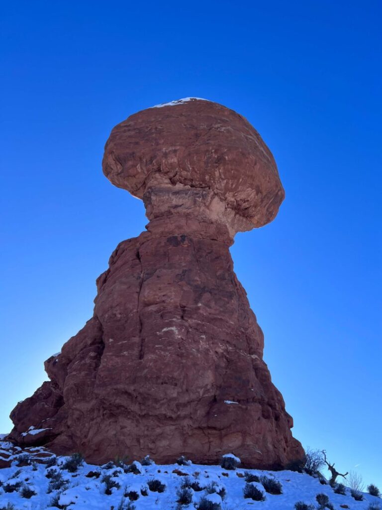
A 3,600-ton boulder on a 128-foot pedestal. Gravity is losing this argument and has been for a very long time.
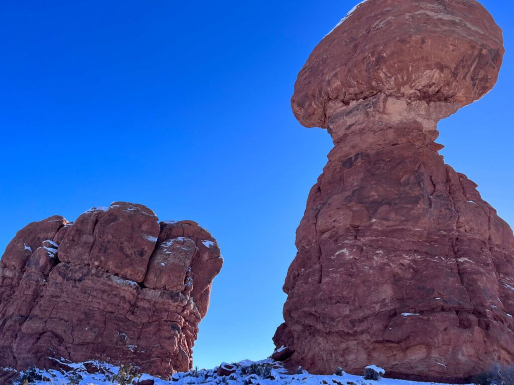
Balanced Rock is one of the most recognizable formations in Arches National Park, visible from the main park road about 9 miles past the entrance station. The trail around it is 0.3 miles of flat loop. It takes 15 to 30 minutes. The rock itself is the whole point: the pedestal is narrow, the boulder on top is enormous, and the engineering of the thing looks impossible until you understand how differential erosion works. Then it looks inevitable. Either way it’s worth the loop. I’ve walked it multiple times as part of longer Arches days and it never loses the effect of being up close to something that size at that angle.
Here’s what you need to visit Balanced Rock.
Quick Facts
|
Trail Name |
Balanced Rock Trail |
|
Location |
Arches National Park, near Moab, Utah |
|
Coordinates |
|
|
Distance |
0.3 miles (loop) |
|
Elevation Gain |
50 feet |
|
Difficulty |
Easy |
|
Time |
15-30 minutes |
|
Dogs Allowed |
No (no pets on Arches trails) |
|
Fee |
$30/vehicle or America the Beautiful Pass |
|
AllTrails |
How to Get There
Arches National Park is 5 miles north of Moab on US-191. From Moab, drive north on US-191 and turn right at the park entrance. A $30 per vehicle fee applies. The America the Beautiful Annual Pass covers it. Follow the main park road (Arches Scenic Drive) for approximately 9 miles. Balanced Rock is on the right side of the road and is visible from the car well before you reach the parking lot turnoff. You cannot miss it. Check recreation.gov for any current timed entry reservation requirements before visiting, particularly in spring and fall peak season.
Parking Information
A designated parking lot sits directly off the main park road at Balanced Rock. Moderate capacity. Fills during peak morning hours on spring and fall weekends. Arrive before 9 a.m. on busy days or accept a wait. Overflow parking runs along the road shoulder near the lot. No restrooms at the Balanced Rock lot specifically. The park entrance station area and the main visitor center have facilities before you drive in.
Cell Service and Navigation
Cell service in Arches National Park is unreliable. Download your trail map offline before leaving Moab. The Balanced Rock loop is 0.3 miles and the formation is visible from anywhere on the trail, navigation is not a concern. The offline map is more useful for planning your full Arches day from a single download before you enter the park.
What to Expect at Balanced Rock
The Loop
The trail starts from the parking lot and circles the base of the formation. The path is mostly flat with a few rocky sections. The formation comes into full view from multiple angles as you walk the loop, each position revealing a different proportion of the boulder to the pedestal. From the south side of the loop you get the full La Sal Mountain backdrop behind the rock. From the north you see the main park road and the desert terrain stretching in both directions. The loop closes back to the parking lot in 15 to 30 minutes depending on pace and how long you stop at each angle.
The Formation
Balanced Rock is Entrada sandstone: the same geological layer that produced most of the famous formations in the park. The pedestal is a softer layer called Dewey Bridge mudstone that erodes faster than the harder Entrada cap. As the pedestal erodes, the boulder on top will eventually fall. A smaller companion boulder that used to sit adjacent already toppled in 1976. The current formation is estimated to have tens of thousands of years remaining, give or take geological uncertainty. Standing below it and looking up at 3,600 tons balanced on that narrowing column gives you a visceral understanding of deep time in a way that descriptions don’t.
Trail Difficulty and Length
Balanced Rock Trail is 0.3 miles with 50 feet of elevation gain on a well-maintained loop. Rated easy. Suitable for all fitness levels, families with young children, and most mobility situations. The few rocky sections require stepping attention. The trail is not paved but is compact and level enough for strollers with assistance on the rocky portions. Budget 15 to 30 minutes for the full loop with time to take photos from multiple angles.
Dog Friendly?
No. Arches National Park does not permit pets on any trails. Dogs are allowed in parking areas, campgrounds, and on paved roads on a 6-foot leash. The Moab area outside the park has dog-friendly trails on BLM land and along the Colorado River corridor if you’re traveling with a dog, including Corona Arch Trail.
What to Bring
Water even for a 15-minute walk in desert heat, the exposed parking area and loop trail can be significantly warmer than the car indicated. Sunscreen and a hat for the open loop. A camera: Balanced Rock is a photography stop as much as a hike. A wide-angle lens captures the full formation in frame from close proximity. A telephoto isolates the boulder-pedestal contact point and compression ratio. The La Sal Mountain backdrop is strongest in the morning before haze builds. Sunset light on the west-facing formation produces orange and red tones worth timing for.
Best Time to Visit Balanced Rock
Spring (March through May) and fall (September through November) are the primary windows. Temperatures are manageable and the formation looks excellent in both the warm morning light and the golden hour before sunset. Summer works for early morning visits before the heat builds. Winter is the least-visited period and the formation occasionally appears with snow on the La Sal Mountains in the background, producing a desert-and-snow composition that’s worth having.
For photography, the two best windows are morning light from the east and the last 30 minutes before sunset when the red Entrada sandstone glows. Sunset crowds at Balanced Rock can be significant in peak season, the formation is close to the road and easy to reach, which makes it a popular evening stop. Arrive 45 minutes before sunset to find your angle before the lot fills.
Rules and Regulations
Balanced Rock Trail is in Arches National Park. A $30 per vehicle entrance fee applies, valid for 7 days. Stay on the designated trail. Do not climb on Balanced Rock or the pedestal. The biological soil crust surrounding the trail is a living organism that takes decades to recover from foot damage. Leave No Trace fully. Timed entry reservations may be required during peak season, check recreation.gov before your visit.
Where to Stay Near Moab
Moab has full lodging coverage 5 miles south of the park entrance. For hotel points check Marriott Bonvoy, IHG Rewards, and Hilton Honors. Staying in Moab gives you the easiest access to both Arches and Canyonlands and puts you within reach of the full range of Moab outfitter and restaurant options.
Camping Nearby
Devils Garden Campground inside Arches National Park is the in-park camping option, reservable through recreation.gov and typically booked months in advance for spring and fall. Moab’s commercial campground corridor and BLM dispersed camping along the Colorado River south of town are the overflow options. Kane Creek Road BLM dispersed sites put you close to town with access to a river corridor.
Nearby Adventures
Balanced Rock sits near the middle of the Arches Scenic Drive and makes a natural mid-day stop on a full park day. The Windows Loop and Turret Arch Trail, about 2 miles further up the road, accesses North Window and South Window in a 1.2-mile loop and is the best next stop after Balanced Rock. Double Arch specifically is one of the most impressive spans in the park and takes under 30 minutes round trip.
Park Avenue Trail near the park entrance is the 2-mile canyon walk through the Courthouse Towers formations that starts the park day well. Delicate Arch Trail (3.2 mi / 480 ft) at the far end of the main road is the park’s signature commitment hike and the one that earns the most reward. Double O Arch Trail at the park terminus gives you access to Landscape Arch and multiple additional arches for a longer day.
Canyonlands National Park Island in the Sky district, about 30 miles from Moab via UT-313, has Mesa Arch for the sunrise shot and Grand View Point for the full canyon panorama. Dead Horse Point State Park is on the UT-313 corridor and worth stopping for the Colorado River horseshoe view.
Plan This Hike
AllTrails has Balanced Rock Trail with a downloadable map and current visitor reports. The most useful check for this short loop is current crowd conditions and any NPS timed entry requirements for the day of your visit. View on AllTrails.
AllTrails Pro is worth it for a full Arches day where you’re planning multiple trails. Download Park Avenue, Balanced Rock, Windows Section, and Delicate Arch in one session before entering the park.
Chase the Quiet
The pedestal narrows as it rises. The boulder on top gets bigger. The contact point between them is the part that stops you. Balanced Rock is a formation that rewards simply standing at the base and looking up at the thing that shouldn’t exist but does. The loop takes 15 minutes. Take 30. Walk the full circle, find the angle that makes the La Sal Mountains appear behind the pedestal, and stay until you’ve absorbed what you’re actually looking at.
Support the Adventure
To make your walls less boring, check out my photography portfolio and bring a piece of the wild and my story into your home.
If you’d like to fuel future adventures, you can donate a coffee on Ko-Fi. Every cup keeps me chasing sunrises and stories.
When you shop using my affiliate links, every click helps support this blog at no extra cost to you. It’s a small way to keep Unicorn Adventure alive and kicking while I keep exploring.
Subscribe to my mailing list for future updates, new stories, and behind-the-scenes adventures.
Stay connected with me on Instagram and Facebook for more photos and daily inspiration.
Thanks for being part of the journey, Unicorn Squadron!

Theo Maynard is a landscape photographer and adventure blogger based in Salt Lake City. He chases remote desert and mountain light across the American West, documents it all solo, and shares the journey through Unicorn Adventure. He’s on the autism spectrum, and that’s not a footnote, it’s the whole story. He creates to inspire others to get outside, chase what lights them up, and live their best possible life. Unapologetically himself.