Corona Arch doesn’t ask for your attention. It doesn’t have a ranger station at the arch, a gift shop at the trailhead, or a license plate with its face on it. It just sits out there on BLM land west of Moab, 140 feet tall and 105 feet wide, doing exactly what it’s always done. That’s part of why I love it. I turned around, drove west on Potash Road along the Colorado River, and found something better for that particular day. A massive arch, a trail with actual elbow room, and a view that earns the drive every time.
If you’ve done Arches and want more, or if you want to skip the national park crowds entirely, Corona Arch is the move. It’s on BLM land, no entry fee, dogs allowed, and the arch itself is genuinely enormous. This guide covers everything you need: how to get there, what the trail is actually like, when to go, and what else to do while you’re in Moab.
Quick Facts
|
Trail Name |
Corona Arch Trail |
|
Location |
BLM Land, near Moab, Utah |
|
Coordinates |
|
|
Distance |
3.0 miles roundtrip |
|
Elevation Gain |
450 feet |
|
Difficulty |
Moderate |
|
Time |
2-3 hours |
|
Dogs Allowed |
Yes, on leash |
|
Fee |
None (BLM land) |
|
AllTrails |
How to Get There
From downtown Moab, head west on Kane Creek Boulevard, which becomes UT-279 (Potash Road). Drive approximately 10 miles along the Colorado River with canyon walls rising on both sides. Watch for the signed Corona Arch Trailhead on the right. You can’t miss the parking area once you’re looking for it.
From Salt Lake City, you’re looking at about a 4-hour drive: south on I-15, east on US-6, and south on US-191 into Moab. From Grand Junction, Colorado, it’s roughly an hour west on I-70 and south on US-191. The Potash Road approach along the river is legitimately scenic, and there are a couple of petroglyph panels visible along the road on the cliff walls. Slow down for those.
No timed entry reservation required. No national park pass needed. You just drive up and start hiking.
Parking Information
The gravel parking lot at the Corona Arch Trailhead holds a decent number of vehicles and is free. It fills up on popular spring and fall weekends, especially mid-morning. Early arrivals rarely have trouble. If the main lot is packed, there’s typically some additional roadside parking along UT-279 near the trailhead.
There’s a vault toilet on site. No water. Fill up in Moab before you go.
Cell Service and Navigation
Cell service is spotty along Potash Road and at the trailhead. You’ll have reasonable coverage in Moab proper, but plan to lose it somewhere along UT-279. Download your AllTrails map offline before leaving town.
The Corona Arch Trail is well-marked with cairns and wouldn’t be hard to navigate even without a map, but having it offline gives you the GPS tracking feature, which is worth it on any desert trail. Don’t rely on live data out here.
What to Expect on the Corona Arch Trail
The Trail
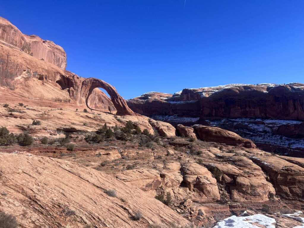
The trail starts with a gentle climb up a slickrock ramp with wide-open views almost immediately. Within the first quarter mile you’re looking out over canyon walls and the Colorado River corridor behind you. The terrain alternates between slickrock, packed dirt, and sandy sections as you wind toward the arch.
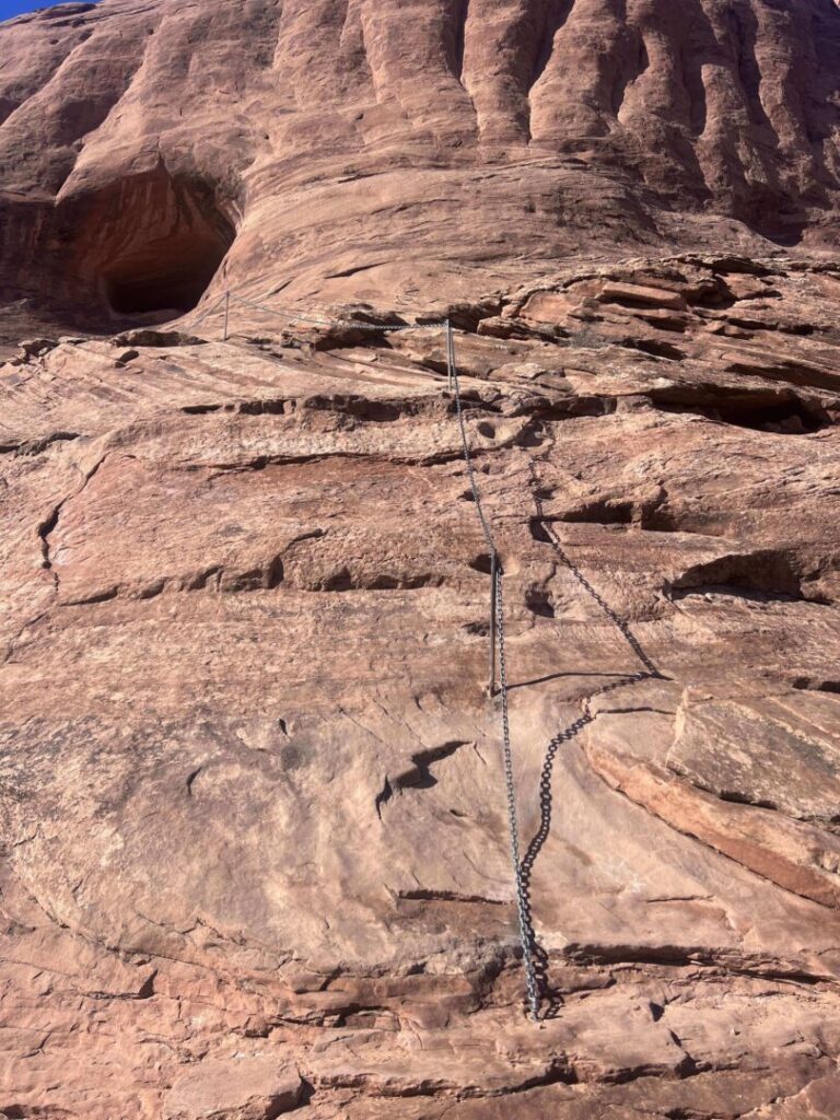
Two spots on the trail require a bit of engagement. First is a short metal ladder bolted to a rock face, maybe 10 feet tall, which gives a lot of people pause on the way up and even more pause on the way down. Take it steady. Second is a cable-assist section where you grab a fixed cable to pull yourself up a steep slickrock slope. Neither is technical climbing, but both require basic comfort with exposure. If your dog isn’t a confident scrambler, assess honestly before committing.
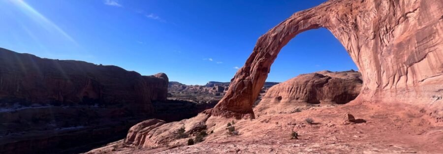
The terrain flattens out as you approach the arch basin. Then you round a corner and Bowtie Arch appears above you first, a smaller hole-in-the-wall arch up on the cliff face. And then, a few more minutes of walking, Corona.
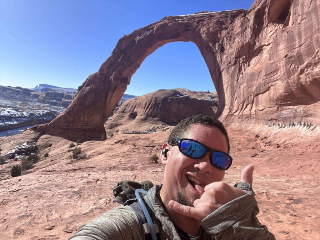
The Arch
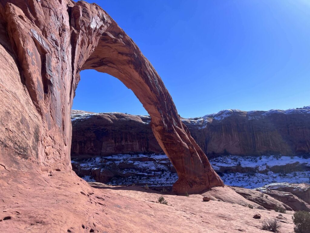
140 feet high. 105 feet wide. Freestanding sandstone. Standing under it puts the scale in perspective in a way photos never quite manage. It’s one of the larger natural arches in the American Southwest, and unlike Delicate Arch, you can walk under it, stand inside the frame, and let your brain try to make sense of the geometry.
The area around the arch has some flat rock for sitting and the views back toward the canyon and river corridor are excellent. This is a good spot to eat lunch, shoot photos at length, and let the place do its thing before heading back.
Trail Difficulty and Length
Moderate is the right call. The 3.0 miles roundtrip go by fast, and the 450 feet of elevation gain is manageable for most hikers. The ladder and cable sections are the parts that trip people up, less from fitness and more from nerve. Kids with outdoor confidence handle them fine. First-timers who are squirrelly about heights sometimes don’t love them.
Plan 2-3 hours for the full round trip at a comfortable pace with time at the arch. Trail runners with light packs move through faster. Photographers who linger at every interesting rock formation move through slower. Both approaches are correct.
Dog Friendly?
Yes, Corona Arch is one of the better dog-friendly trail options in the Moab area precisely because it’s on BLM land rather than inside a national park. Dogs must be on leash at all times.
The honest caveat: the ladder section and the cable-assist slope are legitimately awkward for some dogs. Smaller or less confident dogs might need to be carried up the ladder or may simply turn the trip into a logistics puzzle. Big, athletic dogs handle it without complaint. Know your animal before you commit to the full hike. The arch itself and the slickrock sections before the ladder are gorgeous and worth doing even if you turn around before the technical bits.
What to Bring
Water first, everything else second. The trail is fully exposed and the slickrock amplifies the heat. Bring at least 2 liters per person, more in summer. Dogs need water too, and the trail offers none.
Sun protection: hat, sunscreen, sunglasses. Grippy trail shoes or hiking boots for the slickrock and the ladder sections.
For photography: the arch faces northeast, which makes morning the better light direction for shooting the arch itself. A wide-angle lens is almost mandatory, the arch is big enough that standard focal lengths struggle to capture the full span cleanly. A tripod is useful for pre-sunrise work when the light is low.
Best Time to Hike Corona Arch
Spring and fall are the sweet spots: March through May, September through November. Temperatures are moderate, desert wildflowers sometimes cooperate in spring, and the light in the canyon has warmth without the overhead brutality of summer.
Summer is doable but requires discipline. Start before 7 a.m. or wait until the last two hours of light. The slickrock gets punishingly hot by midday and the exposed sections of the trail offer zero shade. People get into trouble out here in July and August every year. Bring twice the water you think you need.
Winter is quiet and often beautiful. The canyon walls cut the wind and the light is angled low all day, which is genuinely great for photography. Some years bring ice or snow to the slickrock, which makes the ladder and cable sections more challenging. Come prepared or pick a different day.
For the best photography light, morning is the money session. The arch opens northeast and catches direct morning light. Golden hour after sunrise turns the sandstone from red to copper. Plan to be at the arch by 30-60 minutes after sunrise for the best color.
Rules and Regulations
This is BLM land, which means fewer formal regulations than a national park but the same responsibility to leave it intact. Stay on the trail to protect cryptobiotic soil crust. Pack out all trash. Dogs must be leashed.
Do not climb on Corona Arch. The BLM takes arch protection seriously, and so should you. The arch is eroding naturally over geologic time. Human interaction accelerates that.
The trail has become popular enough that rope swings are occasionally set up by thrill-seekers who use the arch as an anchor point. This practice is banned and has resulted in serious injuries and at least one fatality. If you see a rope swing setup, don’t participate and report it.
No entry fee. No permit required. Leave No Trace standards apply: pack in, pack out, don’t cut switchbacks, and respect other hikers on the narrow sections.
Where to Stay Near Moab
Moab is your base for Corona Arch, 10 miles east on UT-279. The town has lodging at every price point from hostel bunks to full-service resort rooms. Red Cliffs Lodge sits on the Colorado River about 14 miles from Moab on Highway 128, with rooms overlooking the river and canyon walls. The location is excellent for early starts and late returns. For points travelers, check available Marriott Bonvoy properties in Moab, IHG Rewards hotels near Moab, and Hilton Honors options in the area. Spring availability in Moab goes fast. Book well ahead.
Camping Nearby
The BLM land around Moab has solid dispersed camping options. Gemini Bridges, Porcupine Rim, and the Sandflats Recreation Area are the go-to spots east of town. Sandflats has both dispersed and fee sites with facilities, and it’s close enough to town to be convenient.
Nearby Adventures
Arches National Park is 15 minutes from the Corona Arch trailhead. If you’ve got the timed entry, plan a full day with Delicate Arch, Park Avenue, and Windows / Turret Arch stacked together.
Canyonlands Island in the Sky district is about 30 miles from Moab via UT-313. Mesa Arch for sunrise and White Rim Overlook for the canyon panorama are the two short hikes worth your time. Aztec Butte Trail adds ancient granaries on the same mesa.
Dead Horse Point State Park, on UT-313 between Moab and Canyonlands, is one of the best overlooks in the state and worth the small extra fee. Hell’s Revenge OHV trail east of town is the iconic Moab off-road experience for capable rigs.
Plan This Hike
AllTrails has Corona Arch Trail mapped with offline GPS tracking and recent condition reports. The condition reports are worth checking before any visit, especially for the ladder and cable section status. Plan your hike on AllTrails and pull the offline map in Moab before driving out.
Chase the Quiet
Corona Arch sits 10 miles from one of the most visited national parks in the United States and almost nobody comes here compared to that. The math on that is generous: BLM land instead of NPS, free instead of $30, dogs allowed instead of banned, no timed entry reservation, and an arch that’s larger and arguably more visually impressive than most of what Arches has on display. The trade is the ladder and the cable. Pay that small price and the rest of the trail is yours.
Support the Adventure
To make your walls less boring, check out my photography portfolio and bring a piece of the wild and my story into your home.
If you’d like to fuel future adventures, you can donate a coffee on Ko-Fi. Every cup keeps me chasing sunrises and stories.
When you shop using my affiliate links, every click helps support this blog at no extra cost to you. It’s a small way to keep Unicorn Adventure alive and kicking while I keep exploring.
Subscribe to my mailing list for future updates, new stories, and behind-the-scenes adventures.
Stay connected with me on Instagram and Facebook for more photos and daily inspiration.
Thanks for being part of the journey, Unicorn Squadron!

Theo Maynard is a landscape photographer and adventure blogger based in Salt Lake City. He chases remote desert and mountain light across the American West, documents it all solo, and shares the journey through Unicorn Adventure. He’s on the autism spectrum, and that’s not a footnote, it’s the whole story. He creates to inspire others to get outside, chase what lights them up, and live their best possible life. Unapologetically himself.