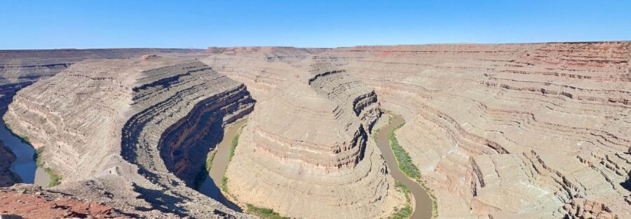
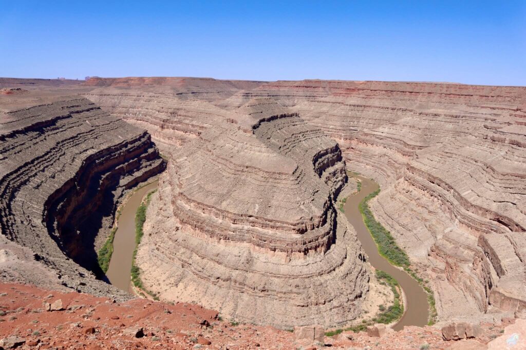
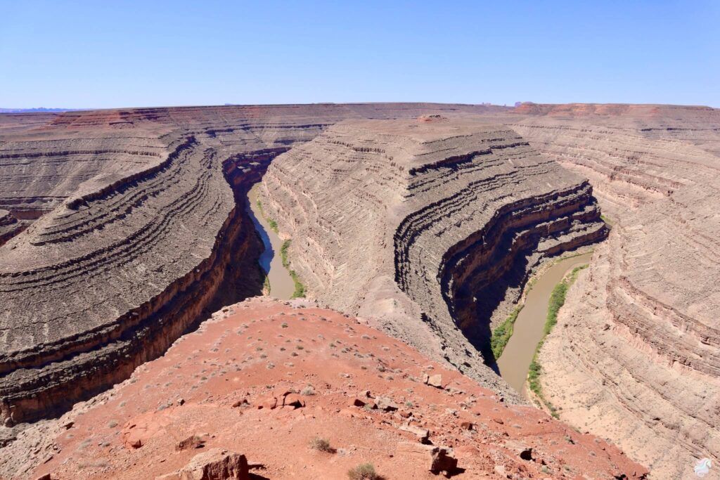
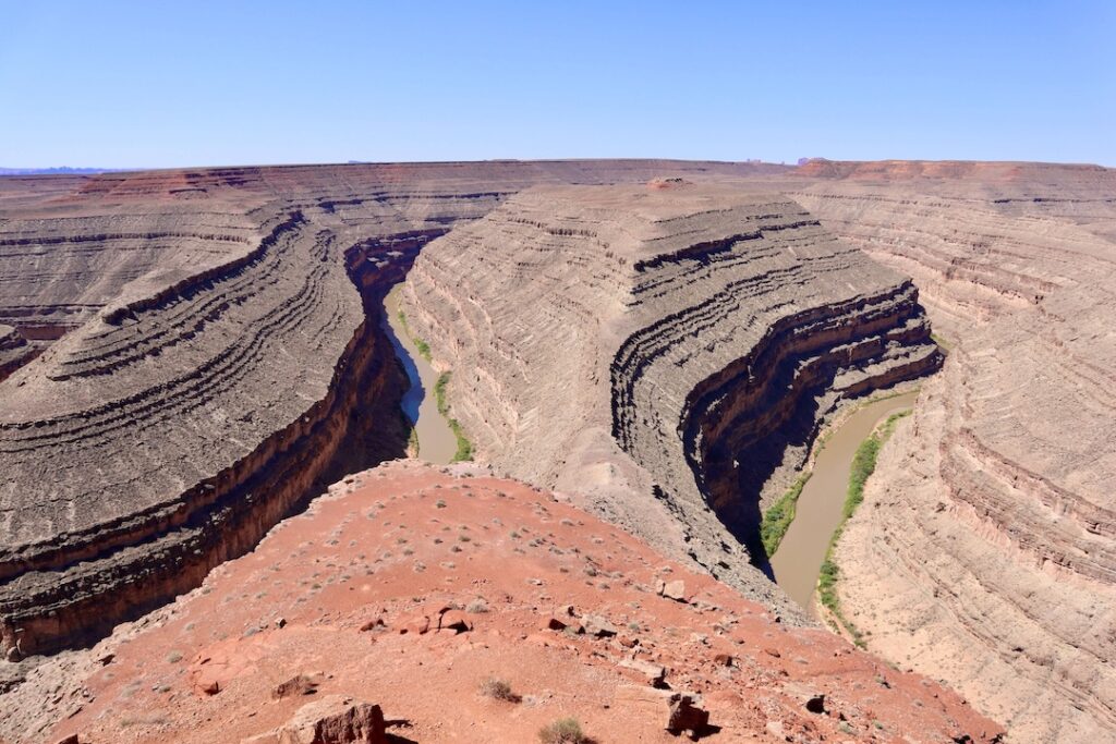
The Goosenecks Viewpoint Trail sits on the edge of one thousand vertical feet of pure exposure. Below, the San Juan River loops back on itself five times, a serpent carved by millions of years of patient stone work. The walk itself is short and easy, but the view stops you cold.
Quick Facts
Trail Name | Goosenecks Viewpoint Trail |
Location | Goosenecks State Park, Mexican Hat, Utah |
Coordinates | |
Distance | 1.8 miles |
Elevation Gain | 95 ft |
Difficulty | Easy |
Time Required | 1 to 2 hours |
Dogs Allowed | Yes (leashed) |
Fee | $5 per vehicle |
AllTrails |
How to Get There
Goosenecks State Park sits about 10 miles north of Mexican Hat, Utah. From Mexican Hat, take US-163 north for about four miles, then hang a left onto UT-261. Follow UT-261 for roughly three miles, then turn left again onto Goosenecks State Park Road. The road is paved and well-maintained, so RVs and trailers can make it in. The drive from Mexican Hat takes about 20 minutes. From Bluff, Utah, it’s around 40 minutes. Pull up at the fee station, pay the $5 vehicle entrance fee, and head in.
Parking Information
The main parking lot sits right next to the viewpoint. There’s space for cars, RVs, and trailers. Picnic tables and shaded pavilions are nearby if you want to sit and soak it in. Restrooms are available near the lot, and the viewpoint is just a short walk from parking. Nothing complicated. Park, walk, stare at the river.
Cell Service and Navigation
Cell service here is spotty. Download your offline maps before you head out. You don’t need GPS for this trail, it’s straightforward from the parking lot to the viewpoint. But if you’re planning the wider area, grab offline versions of Google Maps or Gaia GPS. Make sure someone knows where you’re going and when you’ll be back.
What to Expect on Goosenecks Viewpoint Trail
The Walk
This is a leisurely stroll, not a workout. The trail is less than two miles and mostly flat. The path is sandy and slightly uneven in spots, so good shoes make sense. It’s well-defined, wide, and easy for families and casual hikers. You’ll hit the main viewpoint relatively quickly. The real experience isn’t the walking, it’s the standing.
The Goosenecks
Here’s what you’re looking at. The San Juan River snakes through a canyon in a series of tight hairpin bends that look like a giant serpent from above. The canyon walls rise nearly a thousand feet. The rock is layered in shades of red, orange, and tan. The river below is a thin ribbon of brown from where you stand, but from down there, it’s moving water, carving, doing what rivers do. Sparse vegetation dots the canyon rim. The landscape is stark and beautiful and utterly remote.
Photography and Light
Sunrise and sunset are when this place becomes unreal. The light casts dramatic shadows across the canyon walls and brings out rich warm tones in the rocks. Golden hour here is genuinely golden. If you’re chasing photographs, shoot early or late. Bring a camera that handles contrast well, because the sky is bright and the shadows are deep. The dark skies at night make this a solid spot for stargazing too, if you stay for it.
Trail Difficulty and Length
One point eight miles, 95 feet of elevation gain, and it feels completely manageable. This is an easy hike. Anyone with basic fitness can do it. Kids can do it. Older folks can do it. The trail surface is mostly sandy and slight, not technical. No scrambling. No exposure on the trail itself, though the viewpoint rim requires basic awareness and respect.
Dog Friendly?
Yes. Leash required at all times. This is an open desert with little shade, so bring extra water for your pup, especially in summer. Watch the steep drop-offs around the canyon rim. Keep dogs close. Don’t leave them in a parked car while you hike or explore, the heat builds fast.
What to Bring
Water. Sunscreen. A hat. This place has no shade. Good shoes with grip for sandy terrain. Layers, because desert weather shifts. A camera if you want to capture the light. Binoculars to check out details in the canyon. And if you’re visiting in winter, bring a light jacket or fleece. The sun’s warm, but the shade is cold.
Best Time to Hike Goosenecks Viewpoint Trail
Spring and fall are perfect. March through May and September through early November offer mild temps, clear skies, and incredible light. Summer is scorching. Temps soar above 90, sometimes hitting 100+. If you’re going in summer, hit the trail at sunrise and be off the exposed viewpoint by mid-morning. Winter is cold but quiet, with clear starry nights. Snow is rare but possible. Sunrise and sunset are always the golden hours for photography. If you’re staying nearby, time your visit around these light windows.
Rules and Regulations
Goosenecks State Park is managed by the Utah Division of State Parks. Stay on designated paths. The rock around the canyon rim can be unstable in places, so don’t go poking around beyond the main viewpoint area. Camping is allowed in designated areas only. Fires are permitted in established rings. Drones are prohibited. Pack out everything you pack in. Leave no trace. Respect the park and the view.
Where to Stay Near Mexican Hat and Bluff
Mexican Hat is tiny, so plan to base yourself in Bluff, about 30 minutes away. Bluff has a real small-town feel with local restaurants and character. For something more remote and rugged, you can camp nearby, which we cover below. Monument Valley’s The View Hotel is another option about an hour away if you want something more upscale and closer to the park. For points travelers, check available Marriott Bonvoy properties, IHG Rewards hotels, and Hilton Honors options in the broader Four Corners area.
Camping Nearby
Goosenecks State Park has limited camping options in designated areas near the viewpoint, so check ahead. Muley Point, a few miles west, offers dispersed camping with unreal views. Recapture Reservoir northeast of Bluff has established camping with water and facilities. Valley of the Gods Road has dispersed spots along the drive. BLM land around Cedar Mesa has multiple dispersed options, though water is scarce. Check current regulations before you go, as closures and fire restrictions change seasonally.
Nearby Adventures
Muley Point Overlook is just west, offering sweeping views of Monument Valley, the San Juan River, and Valley of the Gods. The Under the Natural Bridges Loop, about 30 minutes north, is a longer hike that takes you past three distinct natural bridges: Sipapu, Kachina, and Owachomo. Butler Wash Interpretive Trail in Bears Ears is a short drive away and offers easy access to ancient cliff dwellings and petroglyphs. For a scenic drive, head to Moki Dugway or Valley of the Gods, both epic routes through remote country. Visit Bluff Fort in the town of Bluff for a look at restored pioneer cabins. Monument Valley Navajo Tribal Park is about 30 minutes south and worth the time for the iconic red rock landscape and movie history.
Plan This Hike
AllTrails is a solid tool for planning your route and checking recent reviews. You can download offline maps, pin waypoints, and save the trail for later. The community there often flags conditions and seasonal issues. Download the route, offline the map, and you’re set. Use the link below: View on AllTrails.
Chase the Quiet
There’s something about standing on the edge of a thousand-foot drop that simplifies things. The river just flows. The rocks just exist. The canyon just is. And all the noise, all the pressure, all the constant-contact world falls away. You feel small and capable at the same time.
Support the Adventure
To make your walls less boring, check out my photography portfolio and bring a piece of the wild and my story into your home.
If you’d like to fuel future adventures, you can donate a coffee on Ko-Fi. Every cup keeps me chasing sunrises and stories.
When you shop using my affiliate links, every click helps support this blog at no extra cost to you. It’s a small way to keep Unicorn Adventure alive and kicking while I keep exploring.
Subscribe to my mailing list for future updates, new stories, and behind-the-scenes adventures.
Stay connected with me on Instagram and Facebook for more photos and daily inspiration.
Thanks for being part of the journey, Unicorn Squadron!

Theo Maynard is a landscape photographer and adventure blogger based in Salt Lake City. He chases remote desert and mountain light across the American West, documents it all solo, and shares the journey through Unicorn Adventure. He’s on the autism spectrum, and that’s not a footnote, it’s the whole story. He creates to inspire others to get outside, chase what lights them up, and live their best possible life. Unapologetically himself.