Mineral Bottom Road doesn’t ease you in. It starts reasonable enough on the mesa top, a dirt road off UT-313 heading toward the canyon rim, and then the switchbacks begin and the road drops off the edge of the world. Sixteen miles of descent to the Green River on tight, steep turns cut into the sandstone cliff face. The views open up in every direction as you lose elevation. The river appears far below and gets closer. And then you’re at the bottom, in a canyon valley carved by the Green over a time frame that makes the word ancient feel inadequate.
Mesa to canyon rim to canyon wall to canyon floor, with the Green River at the end as the reward for paying attention the whole way down. This guide covers the Mineral Bottom OHV route: what it takes, what to expect on the switchbacks, and how to plan the day around it.
Quick Facts
|
Route Name |
Mineral Bottom OHV Route |
|
Location |
BLM Land, near Moab, Utah |
|
Coordinates |
|
|
Distance |
Approx. 32 miles roundtrip (16 miles each way) |
|
Elevation Gain |
Approx. 2,600 feet |
|
Difficulty |
Moderate (switchbacks require high-clearance 4WD) |
|
Time |
Half-day to full day |
|
Dogs Allowed |
No |
|
Fee |
None (BLM land) |
|
AllTrails |
How to Get There
From Moab, head north on US-191 for about 11 miles, then turn left onto UT-313 toward Canyonlands National Park. Drive UT-313 for approximately 12 miles and watch for the signed Mineral Bottom Road turnoff on the left. The paved road transitions to dirt and begins heading toward the canyon rim. The switchback descent starts after a few miles of mesa-top driving.
From Salt Lake City, plan about 4 hours: I-15 south, US-6 east, US-191 south to Moab, then north to UT-313. From Grand Junction, Colorado, roughly 1.5 hours west. No entry fee, no permit required. BLM land.
Check conditions before committing. Mineral Bottom Road after rain becomes impassable mud on the switchbacks and can strand vehicles with no good recovery options on a narrow cliff-face road. The Moab BLM Field Office can provide current road conditions. This is not a route to guess at after recent precipitation.
Cell Service and Navigation
Cell coverage on UT-313 is marginal and drops to nothing on Mineral Bottom Road and in the canyon. Download AllTrails or a BLM navigation app offline before leaving Moab. Once you’re on the switchbacks, you’re on your own for data.
The route follows Mineral Bottom Road without significant navigation decisions. The switchbacks themselves are clearly defined, there’s nowhere else to go on a cliff-face road. Having GPS active is useful more for tracking your position relative to the bottom than for route-finding. A paper map of the Moab BLM area is worth carrying.
What to Expect on the Mineral Bottom OHV Route
The Mesa Top
The first few miles from UT-313 cross open mesa terrain on a dirt road that’s manageable for most high-clearance vehicles. The views on the mesa top are already solid, with the canyon country visible in the distance and the Green River corridor below on the horizon. This section is where you make your final gear checks before the descent: tire pressure, 4WD engaged, any loose items secured inside the vehicle.
The rim appears with little warning. The road approaches the canyon edge and then the switchbacks begin. From the top, you can see the scale of what you’re about to descend. Take a moment and look. Then go slowly.
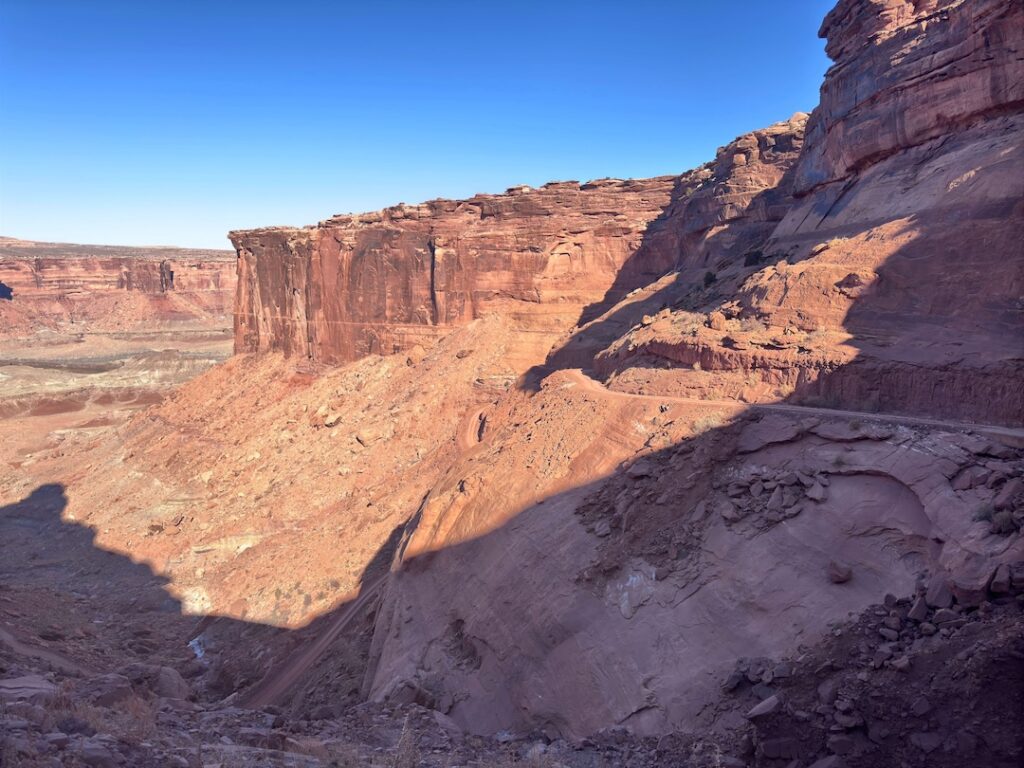
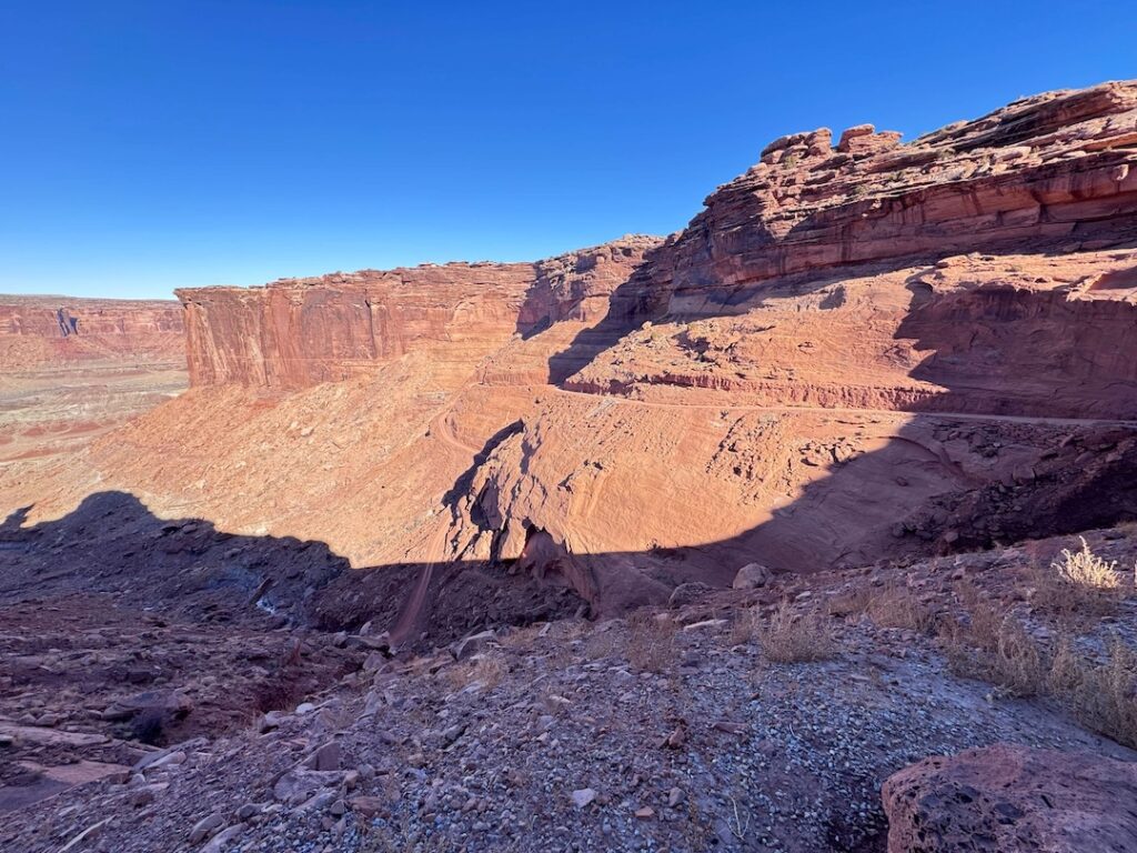
The Switchbacks
The Mineral Bottom switchbacks are the defining feature of this route. They drop roughly 1,400 feet over a series of tight, steep turns cut into the canyon wall. The road is narrow, with the cliff face on one side and a significant drop on the other. In dry conditions with a capable 4WD vehicle and an attentive driver, they are passable. That’s the accurate description.
Go slow. Use low range. Do not attempt to pass oncoming traffic on the switchback sections. If you meet a vehicle coming up while you’re going down, the uphill vehicle typically has the right of way since stopping and reversing on a steep descent is harder. Communicate with other drivers and be prepared to back up to a wider section if needed.
The switchbacks are not appropriate for trailers, RVs, or vehicles with poor brake performance. If your brakes are questionable before you start, this is not the day to find out how questionable. Engine braking in low range is your friend on the descent. Ride the brakes hard on a steep switchback and you will fade them.
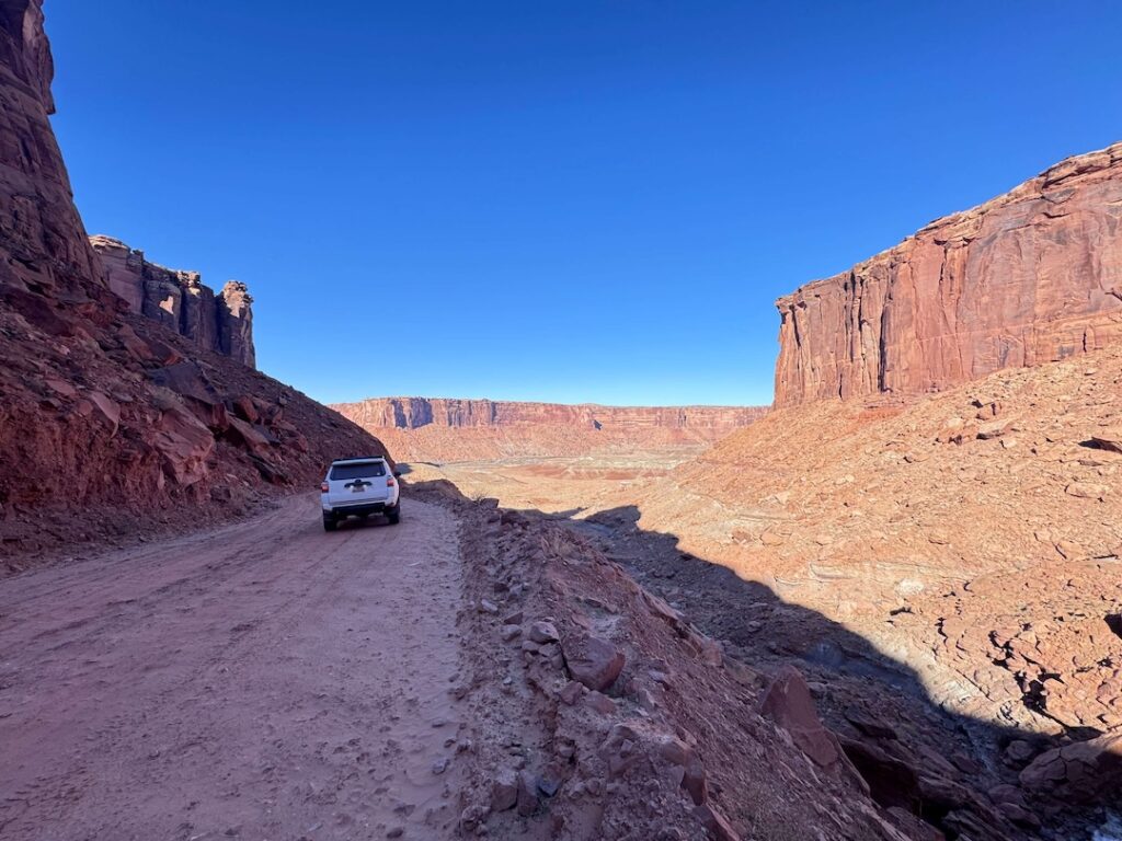
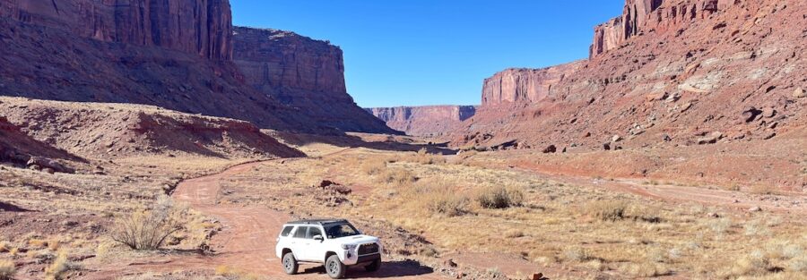
The Valley and the Green River
Past the switchbacks, the road levels into the canyon valley and the character of the drive shifts completely. The terrain opens. The canyon walls frame the valley from both sides. The Green River appears and the road follows it downstream for a stretch before reaching the lower terminus at the boat launch area.
The river at the bottom is quiet, wide, and green in the way the Colorado is not. It carries sediment differently and has a different color in different light. In fall, the canyon walls reflect in the still sections. In spring, the water runs higher and faster. Getting out and standing at the river’s edge after the switchback descent is the earned moment of the route. It’s worth taking.
Drive Difficulty and Length
Moderate is accurate as an overall rating, but the switchbacks specifically are the moderate-plus segment that earns the rating. The full 32-mile roundtrip route covers varied terrain: mesa top, cliff-face switchbacks, and canyon valley floor. Budget a half-day minimum and a full day if you plan to spend time at the river or explore any side features.
The switchbacks require a capable 4WD vehicle with good brakes, low-range capability, and a driver willing to go slowly without rushing. For drivers with off-road experience, this is manageable. For complete beginners, the switchbacks represent a real risk if rushed or attempted in a marginal vehicle. Know your rig and your skill level before committing to the descent.
Wet conditions make the switchbacks significantly more dangerous due to the clay-heavy soil surface. Wait a full day after any rain before attempting.

Dog Friendly?
No. The original post marks this as not dog-friendly, and given the nature of the route, that’s the right call. The switchbacks and the remote canyon environment don’t provide safe conditions for dogs outside the vehicle, and there’s nowhere suitable to stop and let them out on the descent itself. Leave dogs in Moab for this one.
For dog-friendly OHV alternatives out of Moab, Hurrah Pass on Kane Creek Boulevard allows dogs on BLM land and is appropriate for leashed dogs with out-of-vehicle time at the pass. Gemini Bridges is also dog-friendly BLM terrain.
What to Bring
For the vehicle: a full-size spare, a tow strap, a hi-lift jack, and a portable air compressor. A satellite communicator like a Garmin inReach is worth carrying on a remote route of this length with no cell coverage. If something goes wrong on the switchbacks, that device is your connection to help. Know your vehicle’s brake condition before you go.
For you and passengers: water, minimum 3 liters per person for a half-day route in warm weather. Sun protection. Food. The canyon bottom has no services and you’re at least 45 minutes from Moab. Plan like the remote area this is.
For photography: wide-angle for the canyon wall scale from the switchback sections, longer focal length for the river and valley views from the bottom. The switchbacks themselves photograph best from pullout positions looking down the descent, not from inside the vehicle. Stop before the most dramatic sections and get out to shoot.
Best Time to Drive Mineral Bottom
Spring (March through May) and fall (September through November) are the reliable windows. Roads are dry, temperatures are manageable at both rim and river level, and the canyon light has warmth.
Summer is a real consideration here because the canyon valley at the bottom traps heat more than the mesa top. The 1,400-foot descent puts you in a significantly hotter environment at the river. Start early in summer and plan to be ascending the switchbacks before noon. Heat shimmer on the canyon walls mid-afternoon is beautiful to photograph but miserable to experience in a vehicle with no A/C alternative to stopping.
Winter brings the switchback ice risk, which is serious on a cliff-face road. Check conditions carefully. A cold, clear winter day with dry roads can be one of the best times to visit for solitude and low-angle light on the canyon walls. But the margin between clear and icy is thin in canyon country in December and January.
For photography, morning is the better window from the top-down approach. The canyon walls catch eastern light on the descent and the river valley is lit from the east in the early hours. Late afternoon from the bottom looking up is also strong, with the canyon walls going orange before sunset.
Rules and Regulations
Stay on the designated route. The BLM terrain around Mineral Bottom has cryptobiotic soil crust on the mesa top that does not recover from off-route driving. On the switchbacks, there is nowhere to go off route anyway.
Pack out all trash. No camping at the lower terminus boat launch area without a permit. Flash flood risk in canyon country is real, especially in the valley bottom. A storm far upstream on the Green River or its tributaries can send a flood through faster than you can respond. Check the full watershed forecast before descending, not just Moab local conditions.
No fires without a fire pan and current restrictions allowing. Check fire restrictions with the Moab BLM Field Office. The route has no facilities and is genuinely remote. Treat it accordingly.
Where to Stay Near Moab
Moab is the base. The upper trailhead on UT-313 is about 23 miles from downtown Moab, roughly 30-35 minutes. Stay in town and drive out. Red Cliffs Lodge on the Colorado River on Highway 128 and The Caves at Moab are two options with more character than standard chain properties. For points travelers, check available Marriott Bonvoy properties in Moab, IHG Rewards hotels near Moab, and Hilton Honors options in the area. Book well ahead for spring and fall.
Camping Nearby
Dispersed BLM camping is available on the mesa top near the Mineral Bottom Road approach, with open terrain and big views before the switchback descent. Standard BLM rules apply: pack in, pack out, 14-day stay limit, no fires without a fire pan and restrictions allowing.
The Sandflats Recreation Area east of Moab has both dispersed and fee sites with facilities and is the most organized base camp option for Moab OHV trips. Willow Flat Campground inside Canyonlands Island in the Sky is the only developed option near UT-313, first-come first-served, no water, small, and fills quickly in peak season.
Nearby Adventures
The Shafer Trail in Canyonlands National Park is the big-name companion run. It drops off the Island in the Sky mesa via a similarly dramatic switchback descent, longer and more technical than Mineral Bottom, with the White Rim Road at the bottom. The Shafer Trail requires a permit for overnight trips on the White Rim.
Also on UT-313 heading toward Canyonlands, the Island in the Sky district of the park offers several easy-to-moderate hikes that pair well with a Mineral Bottom day. Mesa Arch is a 0.5-mile loop to one of the great sunrise photography locations in Utah. Aztec Butte Trail adds ancestral Puebloan granaries and a slickrock scramble. White Rim Overlook gives you the canyon view from above on a 1.8-mile easy trail.
Plan This Drive
AllTrails has Mineral Bottom OHV Route mapped with offline GPS tracking and recent driver condition reports. The condition reports are worth checking before any descent. Plan your drive on AllTrails and download the offline map in Moab.
Chase the Quiet
The Mineral Bottom switchbacks are the kind of road that gets named after the expression it puts on a driver’s face. Sixteen miles down to the Green River with the canyon walls dropping away on one side and the rock face on the other, low range engaged, slow and steady through every turn. You earn the river at the bottom. The descent is not a check-the-box scenic drive. It’s a piece of road that requires attention and rewards it. The valley below is what the road exists for.
Support the Adventure
To make your walls less boring, check out my photography portfolio and bring a piece of the wild and my story into your home.
If you’d like to fuel future adventures, you can donate a coffee on Ko-Fi. Every cup keeps me chasing sunrises and stories.
When you shop using my affiliate links, every click helps support this blog at no extra cost to you. It’s a small way to keep Unicorn Adventure alive and kicking while I keep exploring.
Subscribe to my mailing list for future updates, new stories, and behind-the-scenes adventures.
Stay connected with me on Instagram and Facebook for more photos and daily inspiration.
Thanks for being part of the journey, Unicorn Squadron!

Theo Maynard is a landscape photographer and adventure blogger based in Salt Lake City. He chases remote desert and mountain light across the American West, documents it all solo, and shares the journey through Unicorn Adventure. He’s on the autism spectrum, and that’s not a footnote, it’s the whole story. He creates to inspire others to get outside, chase what lights them up, and live their best possible life. Unapologetically himself.