Page, Arizona is the convergence point for more accessible desert wonders per square mile than almost anywhere in the American Southwest. Horseshoe Bend, Antelope Canyon, Lake Powell, and the BLM corridor running north through Big Water toward the Grand Staircase-Escalante, it’s all within a half-hour radius. This trip covered five stops over multiple days: Horseshoe Bend again because it earns it every time, Crosby Canyon OHV for an off-road camp, White Pocket for the long-awaited formation experience, The Maze Trail for petroglyphs on the way back, and a winter attempt at the Great Chamber that turned into the right call to turn around. All of it delivered something different. That’s what Page does.
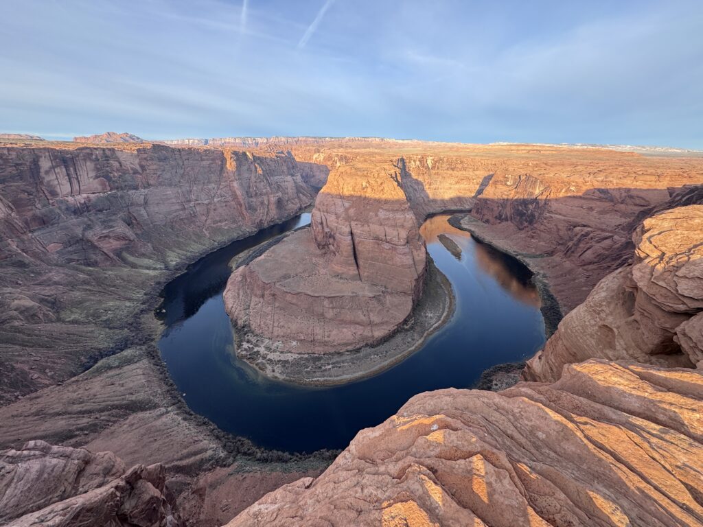
Horseshoe Bend: Still Worth Doing Again
|
Trail |
Horseshoe Bend Trail |
|
Distance |
1.5 miles roundtrip |
|
Elevation Gain |
150 feet |
|
Difficulty |
Easy |
I’ve been here before. The Colorado River making a 270-degree bend around a massive sandstone formation, visible from a 1,000-foot overlook above it, is one of those views that doesn’t diminish with repetition. The walk is 1.5 miles on a paved path. The view is still exactly what it was the first time: the river far below, the canyon walls framing it, and the specific scale of the thing that photographs can’t fully transmit until you’re standing at the edge of it yourself. It warranted the revisit.
Full guide: Horseshoe Bend Trail
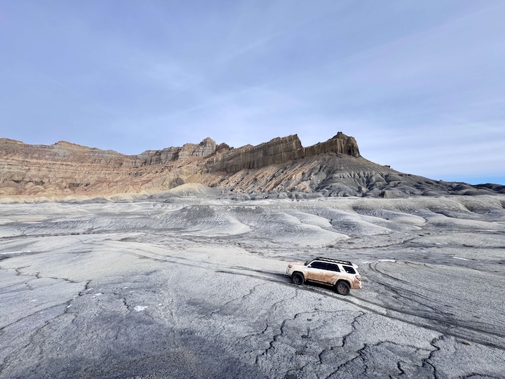
Crosby Canyon OHV: Gravel, Buttes, and a Night Under Desert Sky
|
Trail |
Crosby Canyon OHV |
|
Distance |
~10 miles roundtrip |
|
Elevation Gain |
Minimal |
|
Difficulty |
Moderate (high-clearance 4WD) |
This one is about what the desert feels like from a truck moving through it rather than from a viewpoint above it. Crosby Canyon is gravel, buttes, hills, and the particular freedom of a BLM road with nothing on either side except more desert. I was running it solo, which is the version of off-roading that either delivers exactly the feeling you’re after or reminds you why people don’t do this alone.
The canyon route ends at a Lake Powell beach, and I set up camp there. Desert night under full stars, Lake Powell below the canyon walls, the silence of a place that doesn’t get visitors at that hour. That’s what the BLM access road earns you when you take it seriously: the camp you can’t get to any other way.
Full guide: Crosby Canyon OHV
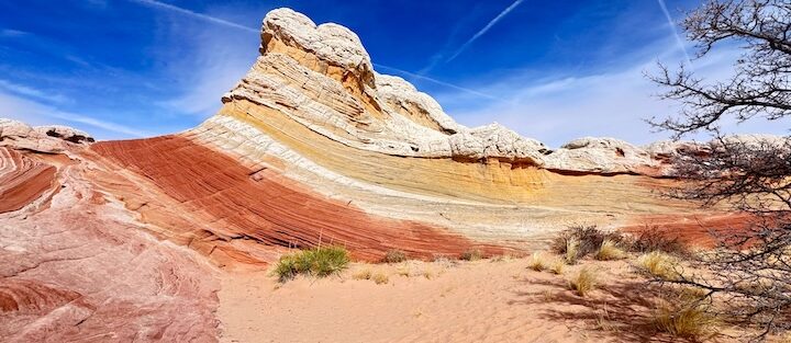
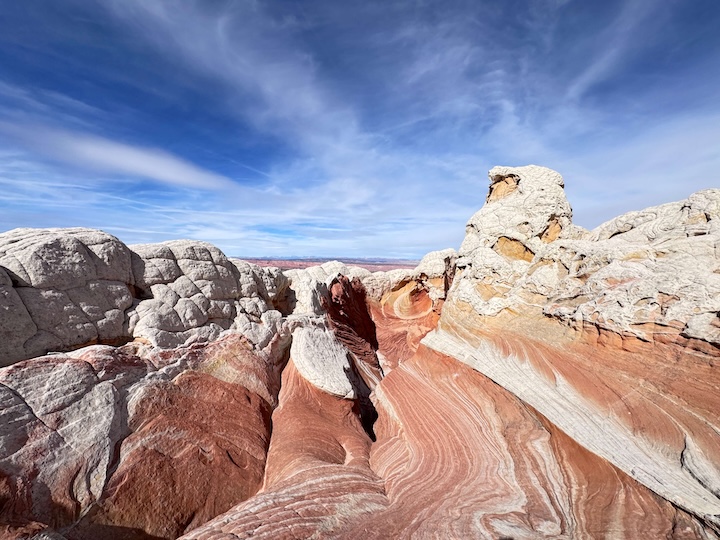
White Pocket: The One That’s Been on the List
|
Trail |
White Pocket Trail |
|
Distance |
1.5 miles (minimum; exploration-based) |
|
Elevation Gain |
160 feet |
|
Difficulty |
Easy to Moderate (high-clearance 4WD to reach trailhead) |
White Pocket had been on the list for a long time. The rough two-hour drive from Page on House Rock Valley Road BLM roads, the tire air-down for the sandy approach, the unmarked pullout that requires having the GPS coordinates loaded before you leave cell coverage. All of it is the access cost for something that doesn’t require a permit when the famous version just a few miles south draws tens of thousands of lottery applications a year.
The formations are white Navajo Sandstone with swirling brain-coral patterns created by differential erosion between layers with different mineral content. The silence out there is complete. Not ‘quiet for a popular trail’ silence. Actually nothing, just wind and the sound of your own breathing and the color of the rock in every direction.
I sat there for a while. The combination of the dead silence, the vibrant whites and reds and yellows of the rock, and the specific feeling of having gotten somewhere that took genuine effort, it hit emotionally in the way that the Colorado Plateau keeps doing if you let it. White Pocket is going to hold a long-term place in the catalog of places I’ll be going back to.
Full guide: White Pocket Trail
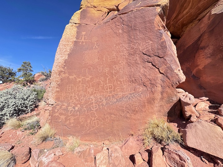
The Maze Trail: Petroglyphs on the Way Back
|
Trail |
The Maze Trail |
|
Distance |
1.3 miles roundtrip |
|
Elevation Gain |
147 feet |
|
Difficulty |
Easy |
On the drive back from White Pocket, I made a stop at The Maze Trail, which leads to petroglyphs that are among the more detailed examples of rock art I’ve seen in southern Utah. It’s 1.3 miles with 147 feet of gain, a short trail from the Kanab area to a rock face with panels that have been there for thousands of years, still readable, still intact. That last part is remarkable: thousands of years of desert sun, wind, and temperature swings haven’t erased them. Whatever medium the people who made them were working in, it was built to last longer than anything most of us will make in our lifetimes.
Stopped for maybe 30 minutes. Worth the detour every time I’m in the area.
The Great Chamber: The Right Call to Turn Back
I tried the Great Chamber in winter. Solo, which in retrospect was the first variable to reckon with. The conditions got icy and snowy a few miles in and the specific combination of ‘alone in the desert, getting colder, miles from pavement’ started to clarify the risk-reward calculation pretty quickly.
I turned back. Not happily, but correctly. The Great Chamber is an extraordinary formation, a massive natural alcove with a sand dune blown into the interior, accessed via BLM trails through Angel Canyon north of Kanab. In dry conditions, with appropriate company or preparation, it’s worth every mile of the approach. In winter ice on an unmarked desert trail, solo, it’s a situation that gets reported as a rescue if you don’t make the right call early.
The plan is a summer return. This isn’t a trail I’m done with. Full guide when I complete it: Great Chamber

Planning a Page, Arizona Trip
A few practical notes that apply across all of this:
The BLM road network north of Big Water off US-89, Smoky Mountain Road and the feeder routes to White Pocket, Crosby Canyon, Wahweap Hoodoos, and Wiregrass Canyon, requires a high-clearance 4WD vehicle and a weather check before every visit. These roads become impassable mud after rain and stay that way for days. Plan for dry weather windows.
AllTrails covers most of the Page area trails and the BLM access routes. Download offline before you leave cell coverage, which happens quickly on all of these approaches. Plan your Page area adventures on AllTrails and pull offline maps while you’ve still got signal.
The Horseshoe Bend lot fills by mid-morning on peak days and charges a $15 parking fee. Everything else in this trip report is free to access. Most things in the Page area still are.
Where to Stay in Page
Page has full chain hotel infrastructure on Lake Powell Boulevard and US-89. For points travelers, check available Marriott Bonvoy properties in Page, IHG Rewards hotels in Page, and Hilton Honors options in Page. Book ahead for spring and fall when Page’s small inventory fills with Grand Canyon and Zion-corridor traffic.
Chase the Quiet
The Great Chamber is still on the list. Unfinished business in the desert is the best kind of unfinished business: it means you have to go back. The Page area has that specific density of things worth doing that makes ‘go back’ feel like planning rather than nostalgia. I’ll be back for the Great Chamber. And probably for White Pocket again. And for whatever is on Smoky Mountain Road that I haven’t found yet. That’s what desert adventure catalogs do: they grow faster than you can hike them.
Support the Adventure
To make your walls less boring, check out my photography portfolio and bring a piece of the wild and my story into your home.
If you’d like to fuel future adventures, you can donate a coffee on Ko-Fi. Every cup keeps me chasing sunrises and stories.
When you shop using my affiliate links, every click helps support this blog at no extra cost to you. It’s a small way to keep Unicorn Adventure alive and kicking while I keep exploring.
Subscribe to my mailing list for future updates, new stories, and behind-the-scenes adventures.
Stay connected with me on Instagram and Facebook for more photos and daily inspiration.
Thanks for being part of the journey, Unicorn Squadron!

Theo Maynard is a landscape photographer and adventure blogger based in Salt Lake City. He chases remote desert and mountain light across the American West, documents it all solo, and shares the journey through Unicorn Adventure. He’s on the autism spectrum, and that’s not a footnote, it’s the whole story. He creates to inspire others to get outside, chase what lights them up, and live their best possible life. Unapologetically himself.