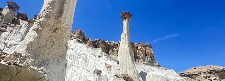
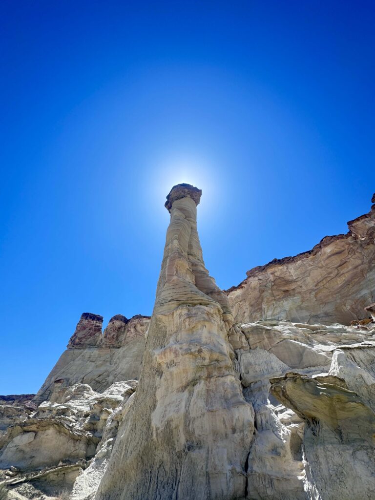
The Wahweap Hoodoos are white Entrada Sandstone columns topped with dark Tropic Shale caps, standing in a remote section of Grand Staircase-Escalante National Monument north of Big Water, Utah. The trail is 8.1 miles with 436 feet of gain. The terrain is mostly flat desert wash with sand that makes the distance feel longer than the elevation change suggests. The hoodoos appear a few miles in and the payoff is one of the more visually unusual formations in the entire monument: pale white columns with dark top hats, dozens of them, in configurations that read as foreign to the typical red-rock palette of southern Utah.
The access to the trailhead requires a 4-mile drive on Ethan Allen Road, a rough dirt road along Wahweap Creek. Flash flood risk is real: the creek bed and the wash sections of the trail collect drainage from miles of plateau above. Check weather for the full upstream drainage before heading out, not just local Big Water conditions.
Quick Facts
|
Trail Name |
The Wahweap Hoodoos Trail |
|
Location |
Grand Staircase-Escalante National Monument, near Big Water, Utah |
|
Coordinates |
|
|
Distance |
8.1 miles roundtrip |
|
Elevation Gain |
436 feet |
|
Difficulty |
Moderate |
|
Time |
4-6 hours |
|
Dogs Allowed |
Yes, on leash |
|
Fee |
None (Grand Staircase-Escalante NM; no entry fee) |
|
AllTrails |
How to Get There
From Big Water, Utah (on US-89 about 15 miles west of Page, Arizona), turn north onto Ethan Allen Road. Follow Ethan Allen Road approximately 4 miles to the trailhead. The road runs along Wahweap Creek and requires a high-clearance vehicle in most conditions; after rain, the road becomes muddy and can be impassable. The trailhead is unmarked; use the GPS coordinates and AllTrails offline map to confirm you’ve reached the right pullout.
From Page, Arizona: US-89 west about 15 miles to Big Water, then north on Ethan Allen Road. From Kanab, Utah: US-89 east about 30 miles to Big Water, then north on Ethan Allen Road. From Salt Lake City: I-15 south to US-89 south through Kanab to Big Water, approximately 5 hours.
Flash flood warning: Wahweap Creek and the wash sections of the trail are real flood risk terrain. Check weather.gov for the entire upstream drainage area before every visit. A storm well upstream can produce a flash flood in the wash without rain at the trailhead. Do not hike if any meaningful storm is forecast for the region.
Parking Information
Small dirt pullout at the trailhead on Ethan Allen Road. No facilities, no fee, no signage. Park off the road surface and ensure you’re not blocking the road as ranchers and service vehicles use the road. No services from Big Water to the trailhead or on the trail.
Cell Service and Navigation
Cell coverage is absent on Ethan Allen Road and throughout the trail. Download AllTrails offline with the GPS track before leaving Big Water. The trail follows Wahweap Creek wash for several miles; the route can be less obvious where the wash braids into multiple channels. Having the GPS track active keeps you on the established route through the branching wash sections.
What to Expect on the Wahweap Hoodoos Trail
The Approach: Wahweap Creek Wash
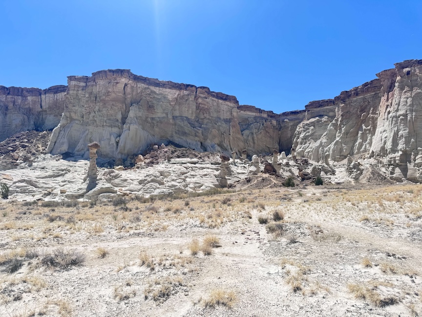
The trail follows Wahweap Creek wash for most of its length to the hoodoo formation area. The landscape starts open and undramatic: broad desert flats, rocky walls in the distance, the standard palette of southern Utah desert. The sandy wash surface is the trail’s defining physical feature: deep sand sucks energy from each step, which makes the 10.4-mile flat trail feel more demanding than the elevation gain suggests. Pace accordingly.
Stay alert to the wash channel. After any recent precipitation, water may be flowing and the creek bed may have soft sections. The farther from the trailhead you go, the more committed you are to the return, plan your turnaround time with the 5+ mile return in mind.
The Hoodoos
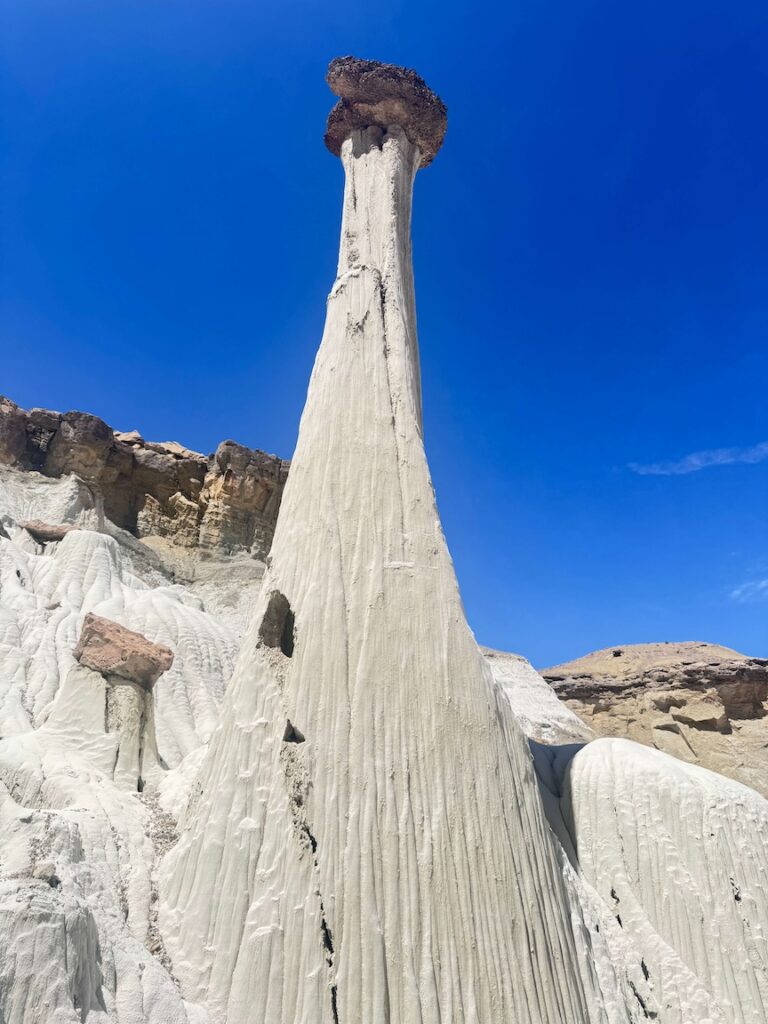
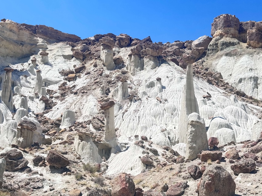
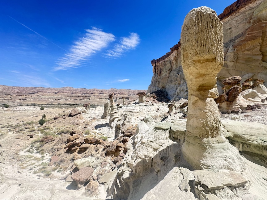
The hoodoo formation area appears a few miles into the hike and the visual transition is immediate. The Wahweap Hoodoos are made of white Entrada Sandstone that erodes more quickly than the darker Tropic Shale cap rock sitting on top. The differential erosion leaves the white columns standing with their darker caps, creating the distinctive two-tone appearance that makes these formations unlike the typical orange-red hoodoos of Bryce Canyon or Cedar Breaks. Dozens of formations at various stages of erosion populate the basin, from tall narrow columns to shorter wider stubs approaching total collapse.
The scale of the hoodoo field rewards slow exploration. The formations continue past the initial cluster and the basin extends in multiple directions from the main trail. Allow real time at the hoodoos rather than a quick glance and return.
For comparison with other hoodoo terrain, Bryce Canyon represents the classic orange-red expression of the same erosion process at a much larger scale.
For photography: sunrise and sunset light softens the white sandstone with warm pink and orange tones. Midday light is harsh and the white rock blows out in direct sun. Morning visits, arriving at the hoodoo field before 9 a.m., give you the best light and the coolest temperatures for the 5+ mile approach. Wide-angle for the hoodoo field context, mid-range for individual formation detail and the cap rock contrast.
Trail Difficulty and Length
The trail is 8.1 miles with 436 feet of elevation gain. Moderate is accurate but deserves the note: 8.1 miles of flat desert sand is more demanding than 8.1 miles on a packed trail with equivalent gain. The sand surface and the lack of shade make the effective difficulty higher than the elevation profile suggests. Budget 4-6 hours for the full roundtrip at a comfortable desert pace with time at the hoodoos.
Dog Friendly?
Yes. Dogs are welcome on leash in Grand Staircase-Escalante NM. The long sandy trail and the desert heat are the primary dog considerations. Bring at least a liter of water for dogs independent of creek access, which requires treatment or filtration. Cactus patches near the trail edges require attention for dog paws. Keep dogs out of the wash channel if water is flowing.
What to Bring
Water: 3-4 liters minimum for an 8-mile desert hike with no shade. The sand and exposed desert terrain dehydrate faster than comparable elevation hiking. Bring more than you think you need. The creek on the approach may provide filterable water but don’t plan your water around it as a primary source.
Sun protection: hat, sunscreen, long sleeves in summer. An early start is mandatory for summer visits; the exposed wash in midday July heat is a serious heat risk. Sturdy trail shoes or boots for the sandy terrain and any rocky sections. Trekking poles help with the sandy walking efficiency.
Best Time to Hike the Wahweap Hoodoos
Spring (March through May) and fall (September through early November) are the reliable windows. Grand Staircase-Escalante summer heat is intense; 10+ miles of exposed desert hiking in 100°F+ temperatures requires extensive preparation and early morning timing. Winter is possible but the access road and wash can have ice in cold snaps, and flash flood risk from snowmelt can be elevated in early spring.
Morning starts are the priority: arriving at the hoodoo field before 9 a.m. delivers the best light and the coolest temperatures before the desert midday heat builds. For a 10.4-mile hike, that means a Big Water departure by 5-6 a.m. in peak season.
Rules and Regulations
Grand Staircase-Escalante National Monument rules apply. Stay on established trails. Do not climb on the hoodoo formations; they are fragile and the cap rocks are unstable. No collecting rocks, fossils, or plants. Pack out all trash. Bury human waste 200 feet from the creek. Dogs on leash. No campfires without checking current restrictions. No fee, no permit required for day hiking.
Where to Stay Near Big Water
Big Water has minimal services (gas, basic supplies). Page, Arizona, 15 miles east on US-89, has full chain hotel infrastructure. Kanab, Utah, about 30 miles west, is the other nearby base. For points travelers, check available Marriott Bonvoy properties in Page, IHG Rewards hotels in Page, and Hilton Honors options near Kanab.
Camping Nearby
Grand Staircase-Escalante NM has dispersed camping throughout the monument with standard BLM rules. No camping in the Wahweap Creek wash itself. The access road and surrounding BLM land have established dispersed camping areas. Page has developed private campgrounds. Wahweap Campground near the Lake Powell marina is about 15 miles east of Big Water.
Nearby Adventures
Toadstool Hoodoos Trail is in the same monument. A shorter and more accessible hoodoo hike in the same monument. Toadstool Hoodoos paired with Wahweap Hoodoos gives you two distinct hoodoo field experiences in the same area on successive days.
The Page, AZ cluster is 15-30 miles east: Horseshoe Bend, Dam Overlook, Glen Canyon Bridge, Beehive/New Wave. A Wahweap Hoodoos morning followed by Page afternoon stops is a natural Big Water area day.
Alstrom Point and Crosby Canyon OHV are the other Big Water area routes, both accessed from Smoky Mountain Road north of Big Water. The Big Water corridor has more to offer than a single day allows.
Plan This Hike
AllTrails has the Wahweap Hoodoos Trail mapped with GPS track and offline capability. Download before leaving Big Water. The GPS track is important for the wash sections where braiding can make the route ambiguous. Plan your hike on AllTrails and pull the offline map while you’ve got signal.
Chase the Quiet
The hoodoos are white in a landscape of red and orange. That’s the whole thing. The Entrada Sandstone erodes faster than the Tropic Shale sitting on top of it, and the result is pale columns with dark hats standing in a remote wash that most people drive past on US-89 without knowing exists. That’s what southern Utah keeps doing: the most unusual formations are not always the most famous ones. The 10-mile walk to see something that doesn’t look like anything else in the monument is the specific version of desert hiking worth showing up for.
Support the Adventure
To make your walls less boring, check out my photography portfolio and bring a piece of the wild and my story into your home.
If you’d like to fuel future adventures, you can donate a coffee on Ko-Fi. Every cup keeps me chasing sunrises and stories.
When you shop using my affiliate links, every click helps support this blog at no extra cost to you. It’s a small way to keep Unicorn Adventure alive and kicking while I keep exploring.
Subscribe to my mailing list for future updates, new stories, and behind-the-scenes adventures.
Stay connected with me on Instagram and Facebook for more photos and daily inspiration.
Thanks for being part of the journey, Unicorn Squadron!

Theo Maynard is a landscape photographer and adventure blogger based in Salt Lake City. He chases remote desert and mountain light across the American West, documents it all solo, and shares the journey through Unicorn Adventure. He’s on the autism spectrum, and that’s not a footnote, it’s the whole story. He creates to inspire others to get outside, chase what lights them up, and live their best possible life. Unapologetically himself.