Calico Tanks Trail is 17 miles from the Las Vegas Strip in Red Rock Canyon National Conservation Area. The 2.3-mile roundtrip leads through red Aztec Sandstone canyons and slickrock scrambling to a hidden water basin, the ‘tank’, and an overlook where the Las Vegas skyline is visible across the desert basin. That combination of red canyon, physical scrambling, and city-in-the-distance view is specific to Red Rock Canyon and not something you can replicate anywhere else in the Southwest.
Quick Facts
|
Trail Name |
Calico Tanks Trail |
|
Location |
Red Rock Canyon National Conservation Area, near Las Vegas, Nevada |
|
Coordinates |
|
|
Distance |
2.3 miles roundtrip |
|
Elevation Gain |
419 feet |
|
Difficulty |
Moderate (rock scrambling required) |
|
Time |
1.5-2.5 hours |
|
Dogs Allowed |
Yes, on leash |
|
Fee |
$15 per vehicle; America the Beautiful Pass accepted. Timed entry reservation required, book at recreation.gov before your visit. |
|
AllTrails |
How to Get There
From the Las Vegas Strip, take West Charleston Boulevard (NV-159) west approximately 17 miles to the Red Rock Canyon Visitor Center. The Calico Tanks Trailhead is at the Sandstone Quarry parking area, about 3 miles into the scenic loop drive.
From downtown Las Vegas, the drive takes about 30-40 minutes. Red Rock Canyon operates on a timed entry reservation system; book your entry slot at recreation.gov before arriving, especially on weekends and peak season. Walk-up entry may not be available on busy days. The reservation system is in place because of the volume of Las Vegas visitors accessing the area.
Parking Information
Small parking lot at the Sandstone Quarry trailhead, 3 miles into the scenic loop. It fills fast on weekends and during the October through April peak hiking season. Arrive before 8 a.m. on busy days or be prepared to wait for a space. If the Sandstone Quarry lot is full, adjacent trailhead lots on the scenic loop may have overflow capacity. The timed entry reservation system helps manage the overall flow but does not guarantee a specific trailhead parking spot.
Cell Service and Navigation
Cell coverage is generally solid near Las Vegas and at the Red Rock Canyon visitor center. It may decrease on the scenic loop and on the trail. Download AllTrails offline before entering the park. The Calico Tanks Trail is well-marked with cairns through the scrambling sections; navigation is manageable but the trail character shifts between washed sand, slickrock, and boulder scrambling that benefit from knowing your route.
What to Expect on the Calico Tanks Trail
The Canyon Approach
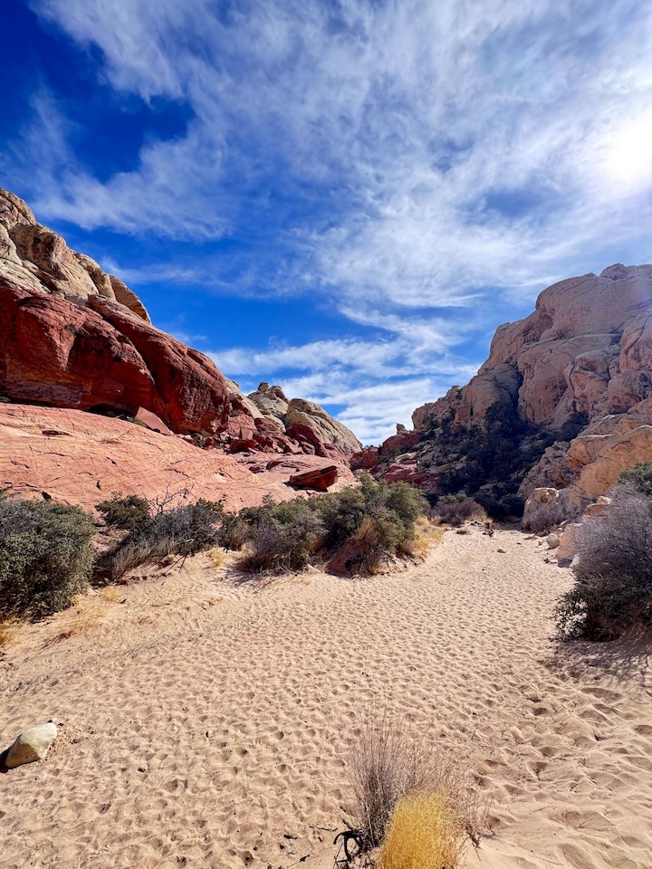
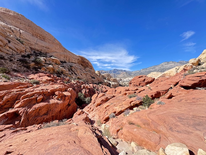
The trail begins in an open wash surrounded by the Calico Hills’ red and orange Aztec Sandstone, the same formation that defines Red Rock Canyon’s distinctive color. The wash leads into narrowing canyons with layered sandstone walls that rise on both sides. The color variation in the rock is dramatic up close: white, pink, orange, and red in distinct bands created by different iron oxide concentrations in each layer. The canyon character shifts throughout the approach, alternating between open wash and enclosed canyon sections.
The Scrambling Sections
Calico Tanks is not a passive trail. Multiple sections require using hands for balance and upward movement over boulders and rock steps. The scrambling is accessible for confident, sure-footed hikers; it’s not technical climbing and doesn’t require special gear. The sections where you use both hands are generally short and have clear routes over the rock. Sturdy shoes with grip are essential, the slickrock sections are specific hazards for smooth-soled footwear.
The Water Tank and Overlook
The ‘Calico Tank’ is a natural sandstone basin that holds water after rainfall. In wet conditions, the pool is a still, clear reflection of the canyon walls above it, a genuine desert surprise. In dry conditions the basin is empty but the smooth sandstone surrounding it is a natural rest spot with canyon views. The pool’s condition is weather-dependent; check AllTrails condition reports for current status before visiting if the water feature is your primary interest.
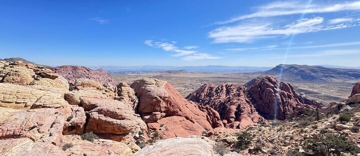
From the overlook above the tank, the Las Vegas skyline is visible to the east. The contrast, red canyon walls and desert silence on one side, the dense urban skyline shimmering across the basin on the other, is the Calico Tanks experience in a single composition. Wide-angle for the skyline-and-canyon combination, mid-range for the tank water detail when present.
For photography: the canyon approach and the slickrock scrambling sections offer rock texture and canyon wall compositions throughout. The tank when holding water is a priority subject: polarizing filter to manage reflection glare, morning light from the east to illuminate the canyon walls above. The overlook skyline view is best in late afternoon when the sun is west of overhead and the city is lit from the side rather than backlit.

Trail Difficulty and Length
Moderate is accurate for a trail with sustained scrambling over uneven terrain. Budget 1.5-2.5 hours for the full out-and-back at a comfortable pace with time at the tank and the overlook.
Dog Friendly?
Yes. Dogs are permitted on leash. The desert heat and the rock scrambling sections are the primary dog considerations. The slickrock and boulder sections require dogs that are comfortable with uneven terrain and some upward scrambling. In summer, rock surface temperatures burn paws quickly; early morning visits are mandatory for dogs in summer months. Bring water for dogs; there’s no water on the trail except seasonally in the tank itself.
What to Bring
Water: 2 liters minimum for a 2.3-mile moderate desert scramble. The exposed red rock radiates heat significantly; water requirements are higher than the distance suggests in warm conditions. Sun protection for the exposed sections. Sturdy hiking shoes or trail runners with grip for the slickrock and boulder scrambling sections. Camera with wide-angle and mid-range capability.
Best Time to Hike Calico Tanks
Summer (May through September): temperatures regularly exceed 100°F and Red Rock Canyon’s rock amplifies the heat. Summer hiking requires departure before 7 a.m. and a strict turnaround time before the canyon heats to dangerous levels. The BLM sometimes closes Red Rock Canyon to entry during extreme heat events.
Golden hour timing is the photography priority: morning from the east illuminates the canyon walls on the approach; afternoon light hits the overlook view and the Calico Hills from the west. A sunrise departure aligns both timing objectives in a single visit.
Rules and Regulations
Timed entry reservation required at recreation.gov before your visit. $15 vehicle fee or America the Beautiful Pass. Stay on designated trails to protect the fragile desert crust. No touching or carving petroglyphs (the Calico Hills area has petroglyphs; follow NPS guidance on location). No removing rocks or plants. Dogs on leash. Leave No Trace throughout.
Where to Stay Near Las Vegas
Las Vegas has comprehensive hotel infrastructure within 17 miles. For points travelers, check available Marriott Bonvoy properties in Las Vegas, IHG Rewards hotels in Las Vegas, and Hilton Honors options in Las Vegas. Properties near the West Charleston / Summerlin area minimize the scenic loop drive time.
Nearby Adventures
Las Vegas area trail options include Ice Box Canyon Trail (2.1 miles / 439 ft, a narrow canyon with seasonal waterfalls), Kraft Mountain Loop (3.6 miles / 620 ft, the higher elevation challenge in Red Rock Canyon), Lost Creek Trail (0.6 miles, petroglyphs and seasonal waterfall), Spooky Canyon (0.8 miles), Valley of Fire entries (Fire Wave / White Domes / Seven Wonders Loop at 3.2 miles / 380 ft, Rainbow Vista Trail at 1.0 mile / 104 ft, Elephant Rock Trail at 0.3 miles / 45 ft), and Lake Mead area (Railroad Tunnel Trail at 8.2 miles / 931 ft, Fortification Hill at 3.5 miles / 1,394 ft, Lake Mead and Hoover Dam Walking Tour at 1.3 miles / 141 ft).
Valley of Fire State Park is about 50 miles northeast of Las Vegas and delivers a completely different desert landscape: bright red and orange Aztec Sandstone with no canyon scrambling, more open, more accessible, more photogenic at a distance. Worth a separate day from the Red Rock Canyon scrambling experience.
Plan This Hike
AllTrails has Calico Tanks Trail mapped with offline capability, current condition reports on the tank water level, and crowd reports that are useful for Las Vegas visitor planning. Download before heading to Red Rock. Plan your hike on AllTrails and book your timed entry at recreation.gov before your visit.
Chase the Quiet
Red Rock Canyon is 17 miles from one of the densest hotel corridors on Earth. From the Calico Tanks overlook, the Las Vegas skyline is visible to the east. You can see the casino towers from the canyon. The canyon is quiet. The trail has rock scrambling and desert silence and the specific stillness of the Mojave. The city is right there on the horizon and it doesn’t touch any of it. That gap between what you can see and where you actually are, that’s what desert proximity to a city delivers when the desert is worth going to. Red Rock Canyon is worth going to.
Support the Adventure
To make your walls less boring, check out my photography portfolio and bring a piece of the wild and my story into your home.
If you’d like to fuel future adventures, you can donate a coffee on Ko-Fi. Every cup keeps me chasing sunrises and stories.
When you shop using my affiliate links, every click helps support this blog at no extra cost to you. It’s a small way to keep Unicorn Adventure alive and kicking while I keep exploring.
Subscribe to my mailing list for future updates, new stories, and behind-the-scenes adventures.
Stay connected with me on Instagram and Facebook for more photos and daily inspiration.
Thanks for being part of the journey, Unicorn Squadron!

Theo Maynard is a landscape photographer and adventure blogger based in Salt Lake City. He chases remote desert and mountain light across the American West, documents it all solo, and shares the journey through Unicorn Adventure. He’s on the autism spectrum, and that’s not a footnote, it’s the whole story. He creates to inspire others to get outside, chase what lights them up, and live their best possible life. Unapologetically himself.