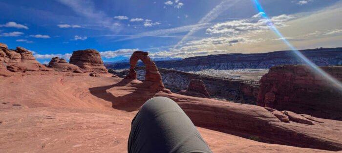
There is a moment on the Delicate Arch trail when the slickrock opens up and the arch just appears, solo against an infinite sky with the La Sal Mountains behind it. No frame. No fence. No interpretation panel telling you how to feel. Just the arch and the wind and the particular silence of a place that has been doing this for 65 million years without your help.
This is the trail that put Utah on the map. It’s on the license plates. It’s in every canyon country coffee table book you’ve ever seen. And it still earns all of it. This guide covers everything you need to hike Delicate Arch without surprises: how to get there, where to park, what the trail actually feels like underfoot, and what to do with the rest of your Moab trip afterward.
Quick Facts
|
Trail Name |
Delicate Arch Trail |
|
Location |
Arches National Park, near Moab, Utah |
|
Coordinates |
|
|
Distance |
3.2 miles roundtrip |
|
Elevation Gain |
480 feet |
|
Difficulty |
Moderate |
|
Time |
2-3 hours |
|
Dogs Allowed |
No |
|
Fee |
$35 per vehicle (America the Beautiful Pass accepted) |
|
AllTrails |
How to Get There
Arches National Park sits 5 miles north of Moab on US-191. From Moab, head north on US-191 and turn right at the park entrance. Follow the main park road for about 12 miles until you see the signed turnoff for Wolfe Ranch. Turn right and drive to the parking area at the end of the road. That’s your trailhead.
From Salt Lake City, expect roughly 4 hours of driving south on I-15, then east on US-6 and US-191. From Grand Junction, Colorado, you’re looking at about an hour west on I-70 and US-191. The approach through the park entrance canyon is worth slowing down for. The rock walls alone justify stopping twice.
Important: Arches requires a timed entry reservation during peak season, typically April through October. Reserve your entry window in advance at recreation.gov. Without a reservation, you’re not getting in during busy periods. Don’t wing it.
Parking Information
Parking at Wolfe Ranch fills fast. On popular spring and fall mornings, the lot can hit capacity before 8 a.m. Your best move is to arrive when the park opens or book a timed entry that aligns with an early window.
If the Wolfe Ranch lot is full, a small overflow area sits nearby, but it fills almost as fast. Rangers do occasionally close the road to the trailhead when both lots are at capacity. The timed entry reservation system helps, but this is still one of the most visited trails in the American Southwest. Plan like it.

Cell Service and Navigation
Cell coverage inside Arches is inconsistent. You’ll have decent signal at the visitor center near the entrance and in Moab proper, but it degrades as you move deeper into the park. At the Wolfe Ranch trailhead, don’t count on reliable data.
Download the AllTrails map or the NPS Arches app offline before you leave Moab. The trail to Delicate Arch is well-marked with cairns and painted lines on slickrock, so navigation isn’t the challenge here, but having a backup map is never a bad idea. Google Maps works fine to get you to the park entrance and trailhead.
What to Expect on the Delicate Arch Trail
The Trail
The first half mile is flat and easy, following a sandy path past the Wolfe Ranch historic cabin, which is worth a 30-second stop. The cabin dates to the late 1800s and gives you a moment to consider that someone actually tried to homestead this desert. Respect.
After the cabin, the trail crosses a footbridge over Salt Wash, then climbs a rocky shelf where a Ute rock art panel is visible. Take a look but stay behind the protective railing. From there, the trail starts ascending slickrock. You’ll follow cairns and painted rock markers across open sandstone domes with big views of the surrounding canyon country. No shade. No shelter. Just you and a whole lot of Entrada Sandstone going orange in the sun.
The final stretch involves traversing a narrow ledge with a sheer drop on the left. It looks more dramatic in photos than it feels in person, but it does require attention. Casual strollers in flip-flops get sketchy here. Don’t be that person.
The Arch
Delicate Arch emerges suddenly at the end of the ledge traverse. You round a corner and there it is, 65 feet tall and freestanding at the edge of a natural bowl, framed by the La Sal Mountains. First time seeing it in person is a hard thing to describe. It’s bigger than the photos suggest. It earns the license plate.
The bowl around the arch can hold a crowd. During peak hours, it does. Give people room. Be patient with groups taking photos. The light is best early morning and late afternoon, and the space feels a little less chaotic at those times too.

Trail Difficulty and Length
Delicate Arch is rated moderate, and that’s fair. The 3.2-mile roundtrip distance isn’t long, but the 480 feet of elevation gain comes mostly in the second half over exposed slickrock. Heat is the real difficulty multiplier here. In summer, the rock absorbs and radiates heat like a furnace.
Sturdy trail shoes or hiking boots are the right call. The slickrock sections don’t require technical footwear, but you want grip. Most reasonably fit hikers will complete the round trip in 2-3 hours. Add time if you plan to linger at the arch for photography, which you should.
Dog Friendly?
No. Dogs are not permitted on the Delicate Arch trail or on any trail within Arches National Park. They’re also banned from the backcountry and any unpaved surface in the park. If you’re traveling with your dog, they’re welcome in parking areas, paved roads, and campgrounds, but leashed at all times. For a dog-friendly alternative in the Moab area, consider the Mill Creek Parkway or Corona Arch Trail on BLM land outside park boundaries.
What to Bring
Water is non-negotiable. Bring at least 2-3 liters per person. There is no water at the trailhead or on the trail. In summer or early fall, go heavier on the water and lighter on everything else.
Sun protection is the next priority: sunscreen, a hat, and sunglasses. The slickrock reflects heat from above and below. Sunburn happens fast. Bring snacks with some salt content if you’re hiking in warmer months, since you’ll sweat out electrolytes on the exposed sections.
For footwear, trail runners or hiking boots. For photography, a wide-angle lens earns its weight here, and the late afternoon light on the arch is genuinely special.

Best Time to Hike Delicate Arch
Spring (March through May) and fall (September through November) are the peak times for good reason. Temperatures sit in a reasonable range and the light has warmth without the brutal summer overhead glare.
Summer hiking is possible but punishing. Start before 7 a.m. or wait until the last two hours of daylight. Midday summer temperatures on exposed slickrock routinely hit 110°F and above. People get into trouble here every year. Don’t be a statistic.
For photography, the arch faces southwest, which means late afternoon into golden hour is the money shot. The inside of the arch catches direct light in the late afternoon, turning the sandstone from orange to copper. Plan your hike to arrive at the arch around 90 minutes before sunset. You’ll share the space with other photographers, but the light makes it worth every one of them.
Winter visits are quiet and cold. The trail can ice up and there’s occasionally snow on the slickrock, which demands microspikes or serious caution. But the solitude is its own reward.
Rules and Regulations
Stay on the designated trail. The cryptobiotic soil crust surrounding the slickrock sections is alive, fragile, and takes decades to regenerate once disturbed. A single bootprint off-trail can undo years of recovery. Walk on rock or sand when off the marked path is unavoidable, but mostly: stay on the trail.
Do not climb on Delicate Arch. The NPS takes this seriously and rangers enforce it. The arch is slowly eroding, and human interaction accelerates that. You’re here to witness it, not test it.
Pack out everything you pack in. No fires anywhere in the park. Drone use requires a special permit that is rarely granted. Timed entry reservations are required during peak season and must be obtained at recreation.gov before arrival. Your America the Beautiful Annual Pass covers the entry fee.
Where to Stay Near Moab
Moab has solid lodging options across every budget. The town sits 5 miles from the park entrance, so you’re never far from an early morning start. For something with character, Red Cliffs Lodge sits on the Colorado River about 14 miles from Moab on Highway 128 and offers rooms with actual canyon views. For points-friendly options, check available Marriott Bonvoy properties in Moab, IHG Rewards hotels near Arches, and Hilton Honors options in the area. Availability in this market during peak season goes fast, so book ahead.
Camping Nearby
Inside Arches, the Devils Garden Campground is the only developed option and it books out months in advance. Reserve at recreation.gov as early as possible if that’s your plan.
BLM land outside the park offers dispersed camping at several spots. Gemini Bridges, Porcupine Rim, and the Sandflats Recreation Area are the go-to spots for Moab-area dispersed camping. Sandflats has both dispersed and fee sites and sits just east of town. The BLM areas generally follow Leave No Trace rules with a 14-day stay limit.
Nearby Adventures
Within Arches, Park Avenue Trail near the entrance, Balanced Rock, and the Windows Loop and Turret Arch Trail make a natural pairing for a full park day. Double O Arch Trail at the end of the park road is the bigger commitment hike that pushes deeper into the Devils Garden corridor.
Canyonlands Island in the Sky is the next-park option, 30 miles from Moab via UT-313. Mesa Arch for sunrise, White Rim Overlook for the canyon view, and Aztec Butte for ancestral granaries and big mesa views.
Corona Arch on BLM land west of Moab is the dog-friendly alternative and one of the best arch hikes outside the parks. Dead Horse Point State Park rounds out the canyon-overlook circuit.
Plan This Hike
AllTrails has Delicate Arch Trail mapped with offline GPS tracking and recent condition reports including timed entry status and parking availability. Plan your hike on AllTrails and pull the offline map in Moab before entering the park.
Chase the Quiet
There’s a version of Delicate Arch that exists between the crowds: sunrise, mid-week in November, when the parking lot has maybe four cars in it and the air is cold enough to see your breath on the slickrock. The arch is the same arch the millions of visitors see. The difference is the silence. That version of the trail is what the alarm clock is for. Set it, drive to Wolfe Ranch in the dark, and walk to the arch as the sky lightens behind it. Worth the lost sleep every time.
Support the Adventure
To make your walls less boring, check out my photography portfolio and bring a piece of the wild and my story into your home.
If you’d like to fuel future adventures, you can donate a coffee on Ko-Fi. Every cup keeps me chasing sunrises and stories.
When you shop using my affiliate links, every click helps support this blog at no extra cost to you. It’s a small way to keep Unicorn Adventure alive and kicking while I keep exploring.
Subscribe to my mailing list for future updates, new stories, and behind-the-scenes adventures.
Stay connected with me on Instagram and Facebook for more photos and daily inspiration.
Thanks for being part of the journey, Unicorn Squadron!

Theo Maynard is a landscape photographer and adventure blogger based in Salt Lake City. He chases remote desert and mountain light across the American West, documents it all solo, and shares the journey through Unicorn Adventure. He’s on the autism spectrum, and that’s not a footnote, it’s the whole story. He creates to inspire others to get outside, chase what lights them up, and live their best possible life. Unapologetically himself.