

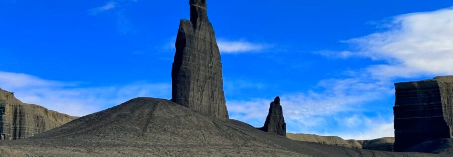
Long Dong Silver might be the most snicker-worthy rock formation in Utah. This slender, fragile sandstone spire rises out of the desert near Hanksville, and yes, it looks exactly like the name suggests. Laugh all you want. Then stand next to it and realize how rare and delicate this thing really is.
I found it after a long day of wandering the Hanksville badlands in Estes, my 4Runner. That’s how I like to explore. No crowds, no schedule, just curiosity and dirt roads. Being autistic, I thrive in places where I can move at my own pace and let my senses settle. This corner of the desert gives you all the space in the world.

Quick Facts
| Trail Name | Long Dong Silver |
| Location | BLM land near Hanksville, Utah |
| Coordinates | Withheld on purpose (see below) |
| Distance | 2 to 4 miles round trip, depending on your starting point |
| Elevation Gain | Minimal, mostly flat |
| Difficulty | Easy |
| Time | 1 to 2 hours |
| Dogs Allowed | Yes, on leash |
| Fee | Free |
How to Get There
I’m keeping the exact location to myself. On purpose. This spire crumbles at the slightest touch, and every extra boot print brings it closer to falling. The information exists out there if you want to dig for it, and if you find it, you’ve earned it. One tip: watch out for the imitation Long Dong Silver nearby. The fake one looks more obvious. The real one is slimmer, and you’ll know it when you look closely. General directions start in Hanksville, the gateway town for this whole region along Highway 24.
Parking Information
There’s no trailhead, no lot, and no signage. You’ll park on the side of a dirt road on BLM land and walk in. Pull fully off the road, park on durable ground, and don’t drive onto the soft desert soil. No restrooms or water anywhere nearby, so fill up in Hanksville.
Cell Service and Navigation
Service in Hanksville runs spotty, and it drops to nothing once you head into the surrounding desert. GPS works, but you won’t get live maps. Download offline maps of the Hanksville area before you leave. With no formal trail, you’ll navigate cross-country over open terrain, so a GPS app with offline maps is essential. Tell someone your plan before you go.
What to Expect on the Hike to Long Dong Silver
The Trail
There’s no official trail here. You’ll walk across open desert, mostly flat, with gentle slopes, loose rock, and soft ground in spots. The route stays simple, but the lack of shade makes it feel harder than it looks, especially in warm months. Stick to washes and rock where you can to avoid crushing fragile desert crust.
The Formation
Long Dong Silver is a tall, slender column of sandstone topped by a slightly wider cap. It stands alone against flat, open terrain, surrounded by mesas, buttes, and eroded badlands. The colors shift from deep red and orange to tan and brown as the sun moves. It looks impossible, like a stiff breeze could knock it over. Honestly, one day it might. Do not touch it, climb it, or lean on it.

The Light
Go at sunrise or sunset. Low sun throws long shadows and lights up the spire against the darker badlands. Midday light flattens everything and bakes you at the same time. For photos, get low and shoot the spire against the sky for the full effect.
Trail Difficulty and Length
Plan on 2 to 4 miles round trip depending on where you park, with minimal elevation gain. The terrain stays mostly flat with some gentle slopes and loose rock. The real challenge comes from exposure. There’s zero shade, and the desert gets brutally hot. Most people finish in 1 to 2 hours, but budget more time if you want to explore the surrounding badlands.
Dog Friendly?
Yes. Dogs are allowed on BLM land. Keep them leashed, especially near the formation, so they don’t bump or dig around its base. There’s no water out here, so carry plenty for your pup. Hot sand burns paws fast in summer. Clean up after them and pack it out.

What to Bring
Bring more water than you think you need, plus salty snacks, a wide-brim hat, sunscreen, and sunglasses. Wear sturdy shoes for loose rock. A GPS app with offline maps is a must since there’s no trail. Carry a first aid kit and a headlamp in case you linger for sunset. My hiking safety gear list covers everything I pack for remote desert hikes.
Best Time to Hike Long Dong Silver
Spring from March to May and fall from September to November bring the most comfortable temps. Summer regularly tops 100°F, so if you go then, start at dawn and be off the desert by mid-morning. Winter stays quiet and cool, but mornings and evenings get cold. For photography, sunrise and sunset deliver the best color and shadow on the spire.
Rules and Regulations
Long Dong Silver sits on public land managed by the Bureau of Land Management. There are no official trails or facilities. Follow Leave No Trace. Walk on durable surfaces, avoid stepping on biological soil crust, and pack out everything. Never touch or climb the formation. It’s fragile, and damage is permanent. Drive only on existing roads. And please don’t post the exact location online. Let it stay a find.

Where to Stay Near Hanksville
Hanksville keeps lodging basic, with a few small motels and a couple of spots to grab food and fuel. For more comfort, head west to Torrey near Capitol Reef. I stayed at the Skyview Hotel there and loved it, and Rim Rock Restaurant serves a great meal with a red rock view. Chain hotels don’t exist out here, so if you’re passing through bigger hubs like Salt Lake City or Green River on your way, check Marriott Bonvoy properties, IHG Rewards hotels, and Hilton Honors options for a points stay.
Camping Nearby
Goblin Valley State Park offers a developed campground with sites and yurts surrounded by wild hoodoos, about 30 minutes north of Hanksville. Reserve ahead in spring and fall. You’ll also find plenty of dispersed camping on BLM land around Hanksville and the San Rafael Swell. Use existing sites, keep fires small and legal, and leave nothing behind.
Nearby Adventures
Hanksville feels like another planet, and there’s a lot to explore. Factory Butte rises out of the badlands like a desert fortress. The Bentonite Hills show off wild, striped clay in every color. Moonscape Overlook lives up to its name. In Goblin Valley, hike the Valley of the Goblins or scramble into Goblin’s Lair. Little Wild Horse Canyon covers 8.0 miles with 787 feet of gain through one of the best slot canyons in Utah. Leprechaun Canyon packs a narrow slot into just 2.2 miles. For more ideas, check out my best hikes in Hanksville and my Hanksville travel guide. Capitol Reef sits just west with classics like Hickman Bridge and Cassidy Arch.
Off the trail, the Mars Desert Research Station adds to the out-of-this-world vibe. It’s not open to the public, but you can see it from the road. Capitol Reef’s Fremont petroglyphs along Highway 24 offer a look at the people who lived here long before us. In Hanksville, grab a burger and fill the tank before heading back out.
Plan This Hike
I’m not linking a map for this one. Finding Long Dong Silver is part of the adventure. For the rest of your Hanksville trip, download offline maps on AllTrails before you lose signal. Its GPS tracking keeps you oriented when there’s no trail and no cell service.
Chase the Quiet
Long Dong Silver made me laugh first and think second. Here’s this ridiculous, fragile spire standing alone in the desert, one bad storm from gone. It felt like a reminder to show up for the weird, temporary wonders while they still exist. Some things don’t wait for you.
That’s what I chase. That’s what Unicorn Adventure is about. Getting out there solo, finding the places that still feel wild, and bringing back stories that remind you the world is bigger than your screen.
To make your walls less boring, check out my photography portfolio and bring a piece of the wild into your home. If you’d like to fuel future adventures, you can donate a coffee on Ko-Fi. Every cup keeps me chasing sunrises and stories.
When you shop using my affiliate links, every click helps support this blog at no extra cost to you. It’s a small way to keep Unicorn Adventure alive and kicking while I keep exploring.
Subscribe to my mailing list for future updates, new stories, and behind-the-scenes adventures. Stay connected with me on Instagram and Facebook for more photos and daily inspiration.
Thanks for being part of the journey, Unicorn Squadron.
Theo Maynard is a landscape photographer and adventure blogger based in Salt Lake City. He chases remote desert and mountain light across America, documents it all solo, and shares the journey through Unicorn Adventure. He’s on the autism spectrum, and that’s not a footnote, it’s the whole story. He creates to inspire others to get outside, chase what lights them up, and live their best possible life. Unapologetically himself.

Theo Maynard is a landscape photographer and adventure blogger based in Salt Lake City. He chases remote desert and mountain light across the American West, documents it all solo, and shares the journey through Unicorn Adventure. He’s on the autism spectrum, and that’s not a footnote, it’s the whole story. He creates to inspire others to get outside, chase what lights them up, and live their best possible life. Unapologetically himself.