Half a mile. Fifty-five feet of elevation gain. Thirty minutes if you take your time. Raven Caves Trail is not trying to impress you with distance. What it has is a short scramble up red rock terrain to a cluster of shallow caves carved into the cliff face, with views back across the desert toward Sedona’s formation corridor and the kind of quiet that larger nearby trails can’t reliably deliver. The trailhead is unmarked, the parking is a dirt pull-off for a handful of cars, and most people driving AZ-89A west of Sedona blow right past it.
Quick Facts
Location | Coconino National Forest, Sedona, Arizona |
Coordinates | |
Distance | 0.5 miles (out and back) |
Elevation Gain | 55 ft |
Difficulty | Easy to Moderate |
Time | 45 minutes |
Dogs Allowed | Yes, on leash |
Fee | No designated parking fee; Red Rock Pass may apply depending on access point |
How to Get There
Raven Caves Trail is accessed from AZ-89A west of Sedona. Drive west on AZ-89A from the main Sedona corridor for about six miles. Watch for a small dirt pull-off on the right side of the road. There is no trailhead sign and no formal marking. The pull-off is easy to miss at highway speed. Slow down once you’ve passed the six-mile mark from Sedona and watch the right shoulder. Loading the GPS coordinates (34.8420, -111.7764) before you leave is the most reliable approach.
Parking Information
Parking is an informal dirt pull-off with space for four to six vehicles. No fee, no kiosk, no facilities. Do not block AZ-89A or encroach on private property. The pull-off is tight and fills quickly on busy weekends. Arrive early in the morning or go on a weekday. If it’s full, there is no nearby overflow option. Come back at a different time rather than parking along the highway shoulder.
Cell Service and Navigation
Cell coverage on AZ-89A west of Sedona is inconsistent depending on your carrier. Verizon holds better than AT&T in this corridor but expect gaps. The trail is short enough that navigation is not a challenge once you’re on it, but finding the unmarked trailhead from the road is where GPS matters most. Download the AllTrails route or drop a pin on the coordinates before leaving Sedona. Having the location loaded before you hit the six-mile mark on AZ-89A is the difference between finding the pull-off on the first pass and overshooting it.
What to Expect on Raven Caves Trail
The Trail
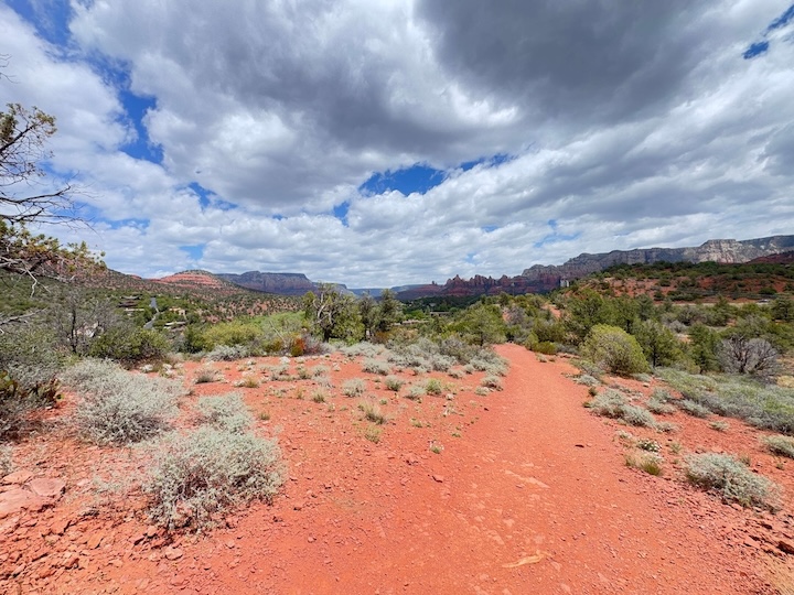
The path moves through open red rock desert from the pull-off, juniper scrub and prickly pear cactus on both sides, with the red cliff face ahead visible almost immediately. The terrain is loose rock and sandy trail for most of the approach, with the grade staying gentle throughout. It is genuinely short. You cover the horizontal distance quickly and the caves appear sooner than expected.
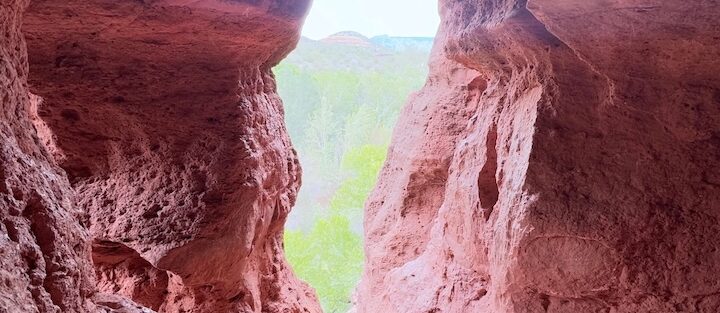
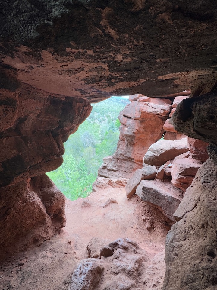
The Caves
The caves are a series of shallow alcoves naturally formed in the red sandstone cliff. They are not deep caves in the spelunking sense. Think wide, low-ceilinged chambers set into the rock face, open at the front with the desert framed in the opening. The final approach involves a brief scramble on rocky terrain to reach the cave entrances. Hands help but it is not technical. Inside the alcoves, the rock walls show the layered geology of the Coconino sandstone up close. The views back across the desert from the cave mouths are the best photography angle on this trail.
The Quiet
Raven Caves Trail’s real offering is the absence of the crowds that define Sedona’s larger trailheads. On a weekday morning, you may have the caves entirely to yourself. The unmarked access and limited parking act as a natural filter. The desert stretches out below the alcoves without anything between you and the horizon. That stillness inside a red rock cave looking out at open Sedona desert is the version of this trail worth finding.
Trail Difficulty and Length
Raven Caves Trail is 0.5 miles out and back with 55 feet of elevation gain. The approach is easy. The final scramble to the cave entrances is moderate in brief bursts, loose rock and a few moves that benefit from solid footwear. Trail shoes or light hikers are appropriate. Nothing here requires technical scrambling skill, but comfortable footwear with grip matters on the final approach. The whole hike takes 30 to 45 minutes at a relaxed pace.
Dog Friendly?
Dogs are allowed on Raven Caves Trail on leash. The short distance makes this manageable for most dogs. The rocky approach and cave scramble are the main paw-concern sections, and prickly pear cactus edges the trail. Bring water for your dog. No sources on trail. Pack out all waste. The informal parking area and lack of trailhead infrastructure means you’re responsible for all your own logistics here.
What to Bring
Half a mile doesn’t require much, but bring water regardless of season. Sunscreen and a hat since the trail has minimal shade on the approach. Grippy trail shoes for the cave scramble. A camera. The cave openings frame the desert view in a way that rewards a horizontal composition, and the layered sandstone interior is worth a close-up shot.
Best Time to Hike Raven Caves Trail
Spring (March through April) and fall (October through November) are the best windows. The trail has minimal shade and heats up quickly in summer. Early morning is the most comfortable time year-round and delivers the best photography light on the cave openings. The caves face generally east-to-southeast, so morning light angles into the alcoves and illuminates the interior walls. Midday light is flat and harsh on the red rock. Sunset from the trail exterior can be good if you position yourself to face west toward the Sedona formations on the return.
Rules and Regulations
Raven Caves Trail sits within Coconino National Forest. Standard forest regulations apply. Stay on the established path. The desert vegetation on both sides of the approach is fragile. No cutting new lines through the scrub to reach the cliff face. No graffiti on the cave walls or surrounding rock. No campfires. No camping at the pull-off or on the trail. Pack out everything you carry in. The unmarked, informal nature of this trailhead makes Leave No Trace practices more important than ever since there is no infrastructure to absorb the impact of careless visitors.
Where to Stay Near Sedona
Raven Caves sits about six miles west of Sedona on AZ-89A, putting you in easy range of all Sedona lodging. For points travelers, Marriott Bonvoy covers Sedona and the Verde Valley. IHG Rewards has properties in the region. Hilton Honors covers Sedona-area properties including options near Uptown and the AZ-89A corridor. The Enchantment Resort near Boynton Canyon puts you closest to the western Sedona trailhead cluster that includes Raven Caves.
Camping Nearby
Dispersed camping along Schnebly Hill Road south of Sedona is the closest established free option. Fox Borough pull-offs, Nolan Tank, and Edge of the World are all free Coconino National Forest dispersed sites within reasonable distance. The Sedona-area dispersed camping coordinates are all accessible with high-clearance vehicles and operate under a 14-day stay limit with no services. No water on site at any of them.
Nearby Adventures
Doe Mountain Loop is a few minutes east on Boynton Pass Road, 2.4 miles and 620 feet of gain with 360-degree mesa views. Fay Canyon Trail is right around the corner at 2.4 miles and 298 feet of gain with a hidden arch and canyon shade that keeps it cooler than most area trails. Boynton Canyon Trail is the full-day option nearby at 6.5 miles and 918 feet of gain with a vortex, the Subway Cave, and ancient ruins. For non-hiking Sedona, the Chapel of the Holy Cross on AZ-179 is the landmark architectural stop. Tlaquepaque Arts and Shopping Village is the best post-trail destination for food and local art. The Amitabha Stupa and Peace Park is a short drive from the Raven Caves area and fits well if you want a quiet, contemplative follow-up to a short morning hike.
Plan This Hike
AllTrails has Raven Caves Trail documented, which is particularly useful here since the trailhead is unmarked and the GPS coordinates are the most reliable way to find the pull-off. Download the offline map and have it running before you reach the six-mile mark on AZ-89A. Plan your hike on AllTrails here.
Chase the Quiet
I sat in the largest alcove at Raven Caves on a Tuesday morning for about fifteen minutes. The cave was cool and quiet, the desert spread out below the opening, a few juniper trees dotting the slope below the cliff face, and the AZ-89A traffic too far back to hear. Half a mile from the highway. That’s how close Sedona keeps something like this. The short trails matter. Not every day calls for eight miles.
Support the Adventure
To make your walls less boring, check out my photography portfolio and bring a piece of the wild and my story into your home.
If you’d like to fuel future adventures, you can donate a coffee on Ko-Fi. Every cup keeps me chasing sunrises and stories.
When you shop using my affiliate links, every click helps support this blog at no extra cost to you. It’s a small way to keep Unicorn Adventure alive and kicking while I keep exploring.
Subscribe to my mailing list for future updates, new stories, and behind-the-scenes adventures.
Stay connected with me on Instagram and Facebook for more photos and daily inspiration.
Thanks for being part of the journey, Unicorn Squadron!

Theo Maynard is a landscape photographer and adventure blogger based in Salt Lake City. He chases remote desert and mountain light across the American West, documents it all solo, and shares the journey through Unicorn Adventure. He’s on the autism spectrum, and that’s not a footnote, it’s the whole story. He creates to inspire others to get outside, chase what lights them up, and live their best possible life. Unapologetically himself.