Moab has a serious density problem. Not a population problem. A too-many-great-hikes-too-little-time problem. Within an hour of downtown you have two national parks, miles of BLM land, and a concentration of natural arches that exists nowhere else on earth. Deciding what to hike requires actual information, not generic superlatives about breathtaking views and must-see destinations.
This list covers 10 hikes worth your Moab days, pulled from Arches National Park, Canyonlands Island in the Sky, and BLM land near town. I’ve hiked all of them. Stats are verified. Difficulty ratings are honest. Dog policies are accurate. No filler.
Quick note on entry: Arches requires a timed entry reservation during peak season (April through October). Book at recreation.gov before you arrive. Canyonlands is expanding its reservation system as well. Check nps.gov before your trip. Both parks cost $35 per vehicle, or free with an America the Beautiful Pass. BLM trails on this list are free with no reservation required.
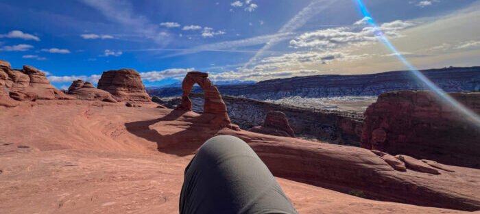
1. Delicate Arch Trail
Arches National Park’s signature hike and Utah’s most recognizable geological feature. The trail starts at Wolfe Ranch, crosses a footbridge, climbs slickrock for most of its length, and ends at a freestanding arch 65 feet tall on the edge of a natural sandstone bowl with the La Sal Mountains behind it. The final ledge traverse has exposure but isn’t technical. The arch earns the license plate every time.
Full guide: Hiking Delicate Arch

2. Double O Arch Trail
The Devils Garden trail system’s deepest reward. The first mile takes you past Landscape Arch, one of the longest natural spans in the world. Past it, the trail shifts onto sandstone fins with real exposure and route-finding that demands attention. Double O Arch, at the end, puts two openings in the same sandstone wall. The loop option adds the primitive route back through even more remote terrain.
Full guide: Hiking Double O Arch Trail
![]()
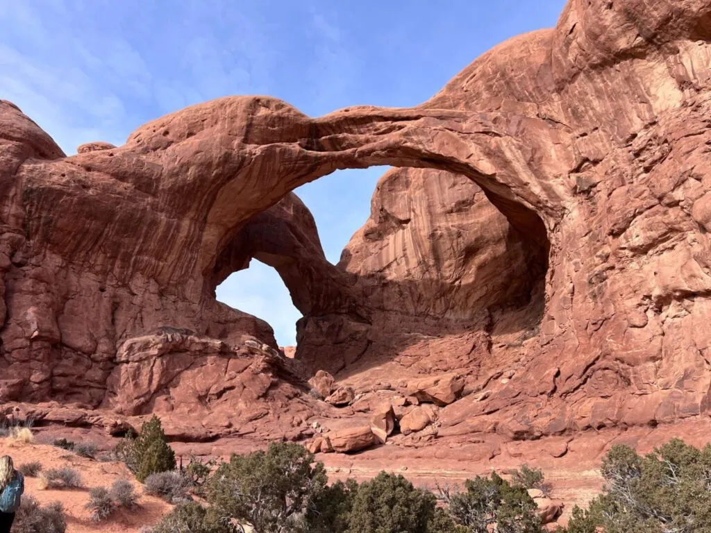
3. Windows Loop and Turret Arch Trail
Three arches, one parking lot, 1.2 miles. The Windows Loop visits North Window and South Window, two massive arches in the same sandstone wall, plus a backside view that most visitors miss by turning around too early. The Turret Arch spur adds 0.3 miles and delivers the best compositional shot in the Windows Section: looking back through Turret Arch toward both Windows simultaneously.
Full guide: Windows Loop and Turret Arch Trail
4. Sand Dune Arch Trail
The shortest hike on this list and one of the most rewarding for the time invested. A corridor between sandstone fins, soft sand underfoot, shade almost the entire way, and a small arch tucked into a quiet pocket at the end. Genuinely beautiful and genuinely easy. The shaded slot makes this one of the few Arches trails that’s tolerable at midday in summer.
Full guide: Sand Dune Arch Trail
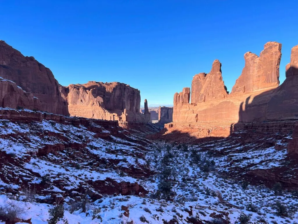
5. Park Avenue Trail
The first major stop after the Arches entrance, Park Avenue runs one mile one-way through a corridor of sandstone fins and monoliths that does resemble, in a very specific geological way, a canyon of buildings. The rock walls tower hundreds of feet above the trail on both sides. Most people do it as a one-way shuttle from the Park Avenue viewpoint to the Courthouse Towers trailhead, with a second vehicle or a ride back. It’s the most dramatic canyon-corridor hike in the park without any significant elevation challenge.
Full guide: Park Avenue Trail
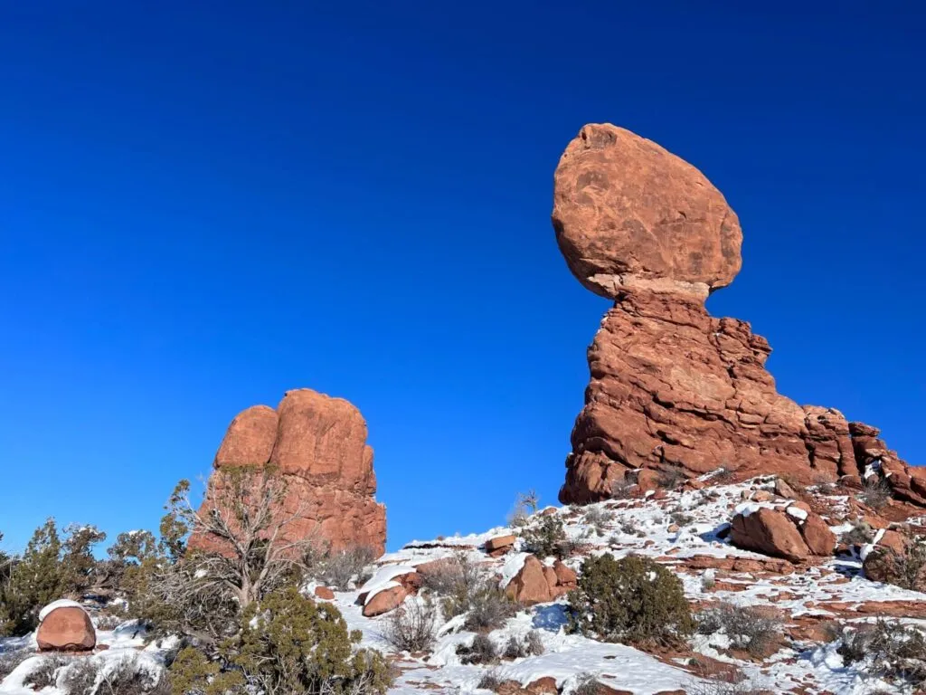
6. Balanced Rock Trail
This is the shortest loop on the list and one of the most satisfying for casual visitors who want a genuine Arches experience without committing to a full hike. The trail circles a formation where a massive boulder sits on an eroding sandstone pedestal in a configuration that looks like it should have fallen sometime in the last century. It hasn’t. The loop takes 15-20 minutes and puts you close enough to the formation to understand the scale of both the boulder and the pedestal holding it.
Full guide: Balanced Rock Trail
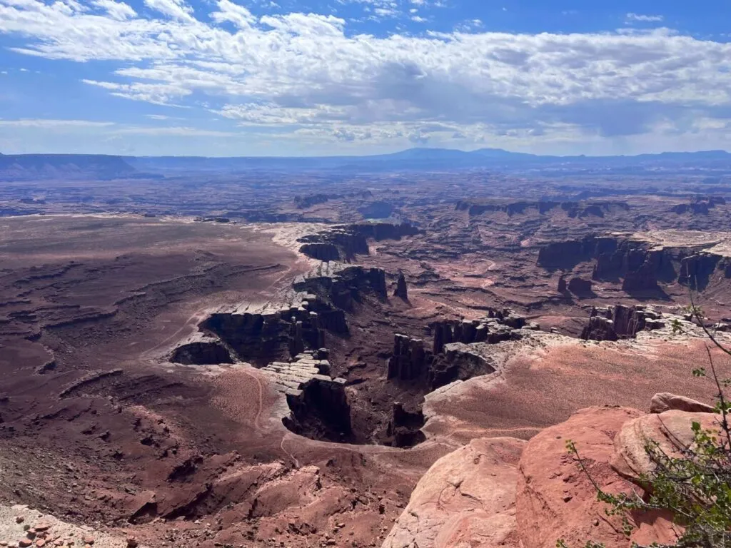
7. White Rim Overlook Trail
The best easy hike in Canyonlands Island in the Sky district for pure view-to-effort ratio. The trail follows the mesa rim south to a viewpoint 1,200 feet above the White Rim Road, with the Colorado River canyon beyond and Monument Basin dropping away to the southeast. The scale is harder to grasp from photos than from the rim itself. Late afternoon light turns the White Rim and canyon walls orange and red.
Full guide: White Rim Overlook Trail
8. Aztec Butte Trail
The most culturally layered hike in Canyonlands. A slickrock scramble to the top of the butte, panoramic views across Island in the Sky, and ancestral Puebloan granaries tucked into the sandstone alcoves at the summit. The granaries are 700-1,000 years old and intact. Don’t touch them. The combination of the scramble, the views, and the history makes this one worth the drive out to the Island in the Sky district even if it’s your only stop.
Full guide: Aztec Butte Trail
![]()
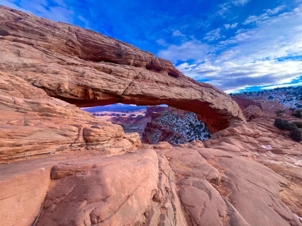
9. Mesa Arch Trail
Canyonlands’ most famous sunrise location. The arch sits at the cliff edge and frames the canyon below in a way that, at first light, glows orange from the reflected canyon walls underneath. It’s a 0.5-mile loop and one of the most photographed spots in Utah. The pre-sunrise parking lot scramble is real: photographers stake positions before first light. If sunrise isn’t your thing, the arch is still worth the 20-minute walk mid-morning for the view of the canyon through and below the opening.
Full guide: Mesa Arch Trail
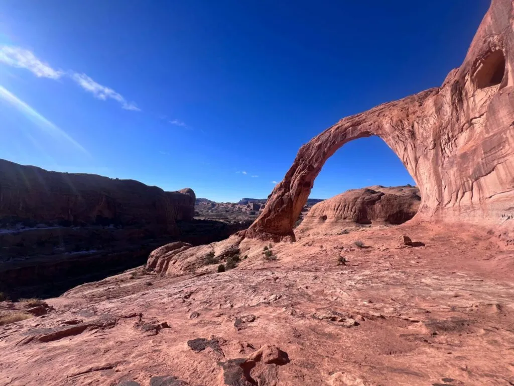
10. Corona Arch Trail
The best hike near Moab that isn’t inside a national park. BLM land, no entry fee, dogs allowed, and a 140-foot-wide freestanding arch at the end of a moderate 3-mile roundtrip. The trail has a short metal ladder and a cable-assist slope that give it some character without making it technical. Corona Arch is massive enough that you can walk under it and look up through the opening. Bowtie Arch is visible from the trail as well. Both arches in one hike, no park pass required.
Full guide: Corona Arch Trail
Planning Your Moab Hike Days
A few practical notes that apply across all 10 of these trails.
Timed entry at Arches is non-negotiable during peak season. Book at recreation.gov before your trip. Without a reservation, you will not get into the park during busy periods. The Windows Section, Devils Garden, and Delicate Arch trailheads all fill fast once the park opens.
Water carrying is not optional. Every trail on this list is desert terrain with no water on route. Bring at least 2 liters per person regardless of trail length. In summer, go heavier.
AllTrails has all 10 of these trails mapped with offline capability. Download maps before you enter the parks since cell coverage drops inside both Arches and Canyonlands. Build your Moab hike list on AllTrails and pull offline maps in Moab before heading out.
The America the Beautiful Annual Pass covers both Arches and Canyonlands entry fees ($35 each per vehicle) and pays for itself in two visits. Worth buying if this is a multi-park trip.
Where to Stay Near Moab
Moab is the base for all 10 of these hikes. The town sits 5 miles from the Arches entrance and 32 miles from the Canyonlands Island in the Sky entrance. Everything on this list is a reasonable day trip from a Moab hotel. Red Cliffs Lodge on the Colorado River (Highway 128) and The Caves at Moab are two options with genuine character. For points travelers: Marriott Bonvoy properties in Moab, IHG Rewards hotels near Moab, and Hilton Honors options in the area. Spring and fall Moab availability disappears fast. Book early.
Chase the Quiet
Ten hikes is a list. What it doesn’t capture is what it feels like to be at the right one at the right time, when the light comes from the angle you drove four hours to find and the people who were there an hour ago have cleared out and it’s just you and the arch or the rim or the canyon or whatever form the desert is taking that morning. That’s the version of Moab worth planning around. These trails get you there. The rest is showing up.
Support the Adventure
To make your walls less boring, check out my photography portfolio and bring a piece of the wild and my story into your home.
If you’d like to fuel future adventures, you can donate a coffee on Ko-Fi. Every cup keeps me chasing sunrises and stories.
When you shop using my affiliate links, every click helps support this blog at no extra cost to you. It’s a small way to keep Unicorn Adventure alive and kicking while I keep exploring.
Subscribe to my mailing list for future updates, new stories, and behind-the-scenes adventures.
Stay connected with me on Instagram and Facebook for more photos and daily inspiration.
Thanks for being part of the journey, Unicorn Squadron!

Theo Maynard is a landscape photographer and adventure blogger based in Salt Lake City. He chases remote desert and mountain light across the American West, documents it all solo, and shares the journey through Unicorn Adventure. He’s on the autism spectrum, and that’s not a footnote, it’s the whole story. He creates to inspire others to get outside, chase what lights them up, and live their best possible life. Unapologetically himself.